博文
击垮美国地震学家信心的2004年Parkfield 6.0级地震
||||
经过20年的苦等,圣安德烈斯断层被重点科学监测的部分,在2004年9月27日发生了6.0级地震。
“这次地震拖延的时间太久了”,Hough 说:“超出窗口16年或12年。”(参见:Lubick N.帕克菲尔德最终还是震了.国际地震动态,2005,No.2.)
想知道预期中的地震为何迟到吗?
可参考俺前几天写的一篇博文:
为何预期中的Parkfield 6.0级地震姗姗来迟?
http://blog.sciencenet.cn/home.php?mod=space&uid=575926&do=blog&id=678547
若想了解有关该地震的详细情况,请接着往下看:
The Parkfield, California, Earthquake Experiment
September 28, 2004—M 6.0 earthquake captured
The Parkfield Experiment is a comprehensive, long-term earthquake research project on the San Andreas fault. Led by the USGS and the State of California, the experiment's purpose is to better understand the physics of earthquakes - what actually happens on the fault and in the surrounding region before, during and after an earthquake. Ultimately, scientists hope to better understand the earthquake process and, if possible, to provide a scientific basis for earthquake prediction. Since its inception in 1985, the experiment has involved more than 100 researchers at the USGS and collaborating universities and government laboratories. Their coordinated efforts have led to a dense network of instruments poised to "capture" the anticipated earthquake and reveal the earthquake process in unprecedented detail.
Hypothesis
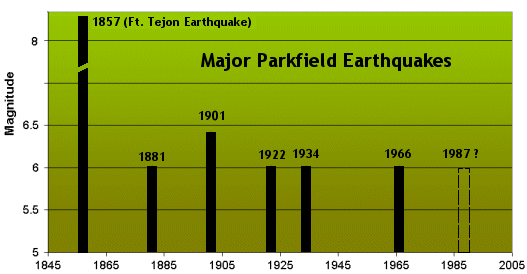
Moderate-size earthquakes of about magnitude 6 have occurred on the Parkfield section of the San Andreas fault at fairly regular intervals - in 1857, 1881, 1901, 1922, 1934, and 1966. The first, in 1857, was a foreshock to the great Fort Tejon earthquake which ruptured the fault from Parkfield to the southeast for over 180 miles. Available data suggest that all six moderate-sized Parkfield earthquakes may have been "characteristic" in the sense that they all ruptured the same area on the fault. If such characteristic ruptures occur regularly, then the next quake would have been due before 1993.
These pages describe the scientific background for the experiment, including the tectonic setting at Parkfield, the historical earthquake activity on this section of the San Andreas fault, the monitoring and data collecting activities currently being carried out, and plans for future research. Data are available to view in real-time and download.
Scientific Advances
While the greatest scientific payoff is expected when the earthquake occurs, our understanding of the earthquake process has already been advanced through research results from Parkfield. Some of the highlights are described.
Data
Real-time data from instrumentation networks running at Parkfield are available for viewing and downloading
Magnitude 6.0 - CENTRAL CALIFORNIA
2004 September 28 17:15:24 UTC
Earthquake Details
This earthquake is the anticipated Parkfield earthquake, Mw 6.0 on the San Andreas fault. It ruptured roughly the same segment of the fault that broke in 1966. The earthquake occurred at 10:15 AM PDT on September 28, 2004. Its hypocenter was located at 35 degrees, 49 minutes north, 120 degrees 22 minutes west, at a depth of 8 km or 5 miles. From this point, about 7 miles SW of the town of Parkfield, it ruptured primarily northwest along the San Andreas fault. Strong shaking during this event lasted for about 10 seconds. This earthquake is the seventh in a series of repeating earthquakes on this stretch of the fault. The previous events were in 1857, 1881, 1901, 1922, 1934, and 1966.
6.0 | |
| |
35.815°N, 120.374°W | |
7.9 km (4.9 miles) | |
CENTRAL CALIFORNIA | |
| |
horizontal +/- 0.4 km (0.2 miles); depth +/- 0.6 km (0.4 miles) | |
NST=248, Nph=248, Dmin=3 km, Rmss=0.11 sec, Gp= 94°, | |
nc51147892 |
This event has been reviewed by a seismologist.
Did you feel it? Report shaking and damage at your location. You can also view a map displaying accumulated data from your report and others.
Still waiting for the 1987 Parkfield earthquake
The San Andreas Fault (SAF) passes through the small town of Parkfield, California, which is situated roughly halfway between Los Angeles and San Francisco. Parkfield has experienced strong (at least M6) earthquakes six times between 1857 and 1966. These quakes, have an average repeat interval of 22 years (24, 20, 21, 12 and 32 years). Excluding the larger and more extensive 1857 earthquake, they have all occurred on almost exactly the same part of the fault. Furthermore, the 1934 and 1966 quakes have very similar-looking seismographs, and each was preceded by a M5 foreshock 17 minutes before the main shock. Another similar earthquake was expected to occur at Parkfield by around 1987, but it still hasn’t happened, and the gap is now 36 years.
(For more information on the history of earthquakes at Parkfield see: http://www.johnmartin.com/earthquakes/eqpapers/00000075.htm)

In the mid 1980s the USGS and several California universities initiated an intensive seismic monitoring program at Parkfield. The program now includes the following instrumentation:
12 creep meters (to measure slow aseismic slip on the fault) |
2 electronic distance measurement instruments (to monitor displacement) |
12 GPS stations (to monitor displacement) |
8 dilatational strain meters (to assess strain build-up in rocks) |
3 tensor strain meters (to assess strain build-up in rocks) |
12 short-period seismometers |
10 bore-hole seismometers |
30 strong motion sensors (to measure the ground motion associated with a large earthquake) |
a 2.2 km deep borehole with various instrumentation |
a proposed 4 km deep borehole with various instrumentation |
Amongst numerous other studies, earth scientists are monitoring water levels in wells and analyzing data from satellites to assess ongoing ground displacement.
(For more information on the research at Parkfield see: http://www.scec.org/instanet/01news/es_abstracts/langbeinES1.pdf)
This unparalleled research effort is being conducted for two main reasons. Firstly, the relatively simple geometry of the SAF at Parkfield allows for a clear understanding of strain accumulation and release on the fault. Secondly, the apparent regularity of the historic earthquakes at Parkfield makes this an ideal site for testing the “time-predictable recurrence model” developed in the 1980s (Shimazaki and Nakata, 1980).
Some of the data gathered at Parkfield over the past few decades have been recently analyzed by geophysicists from Stanford University. Their goal is to understand why there is now a 36-year gap between major earthquakes at Parkfield. Murray and Segall (2002) have estimated the rate of strain accumulation on the Parkfield segment of the SAF, and they conclude that the most of the strain released by the 1966 quake had re-accumulated by 1981, and that there is a 95% probability that another large quake should have occurred by 1987. In carrying out this analysis Murray and Segall recognized that some of the strain at Parkfield could have been relieved by the nearby M6.5 Coalinga quake of 1983, and that this could have delayed Parkfield by about 2 years. On the other hand, they also calculate that two small earthquakes in the Parkfield area in 1992 and 1994 (around M4) actually increased strain on the Parkfield rupture zone, essentially countering the delaying effect of the Coalinga quake.
The only explanation offered by Murray and Segall is that local variations in pore-water pressure may have affected the tendency for failure on the Parkfield segment – although they have no means of measuring this parameter.
Murray and Segall go on to argue that the 36 years worth of strain that has now accumulated at Parkfield is substantially more than that which had accumulated prior to the previous six large earthquakes, and therefore if the segment fails soon (eg. in 2002 or 2003) the resulting quake will likely have a magnitude between 6.6 and 6.9 – which would be significantly more damaging than any of the past five Parkfield earthquakes.
References
Murray J and Segall P, Testing time-predictable recurrence by direct measurement of strain accumulation and release,Nature, V. 419, p. 287-291 (September 2002).
Shimazaki K and Nakata T, Time-predictable recurrence model for large earthquakes, Geophysical Research Letters, Vol. 7, P.279-282 (1980)
附录:地震预测试验场的有关资料
地震预测试验场的概念至少可以追溯到20世纪60年代大规模的地震预测研究刚刚开始的时候。60年代以来,苏联先后在加尔姆—杜尚别、伏龙芝、塔什干、阿什哈巴德、阿拉木图、喀尔巴阡、堪察加等地,美国在加州帕克菲尔德等地,中国在滇西等地, 土耳其与德国合作在北安纳托利亚, 欧洲在冰岛等地实施了地震预测试验场计划,在日本东海地区和中国京津唐张地区,有针对性地加强了观测和地震预测研究,在相当意义上也构成了地震预测试验场。
迄今尽管地震预测试验场在地震观测和研究方面取得大量有价值的成果,但在真正的预测检验方面却成果甚少。美国地球物理学家发现,在帕克菲尔德附近的圣安德烈斯断层上的同一地区,发生过若干次中等地震,这些地震的时间间隔约为22年。据此,研究人员认为1988至1993年,这里还将发生另一次5.5至6级的“特征地震”。1984年起,美国地质调查局(USGS)选定这一地区作为地震预测试验场,布设了大量仪器,以监测地应变、地倾斜、断层蠕动、地震活动和各种地球物理场的变化,并详细地研究当地的地壳上地幔结构和地球动力学模型。为对这次“即将到来”的地震做出试验性的预测,地震学家甚至制定了发布临震预报和地震警报的方案。然而,时至2003年,地震学家“等待”的地震仍没有发生,而距帕克菲尔德不远的1989年洛马普列塔地震、1992年兰德斯地震、1994年北岭地震等一系列地震,都没有发生在地震学家“安排好”的地方。时至1993年,地震学家便开始宣称这一试验“已告失败”。
https://m.sciencenet.cn/blog-575926-680023.html
上一篇:科学研究的误区【3】:熟视无睹
下一篇:科学研究的误区【4】:发现问题比解决问题重要?
全部作者的精选博文
- • 日本西海岸7.5级地震意欲何为?
- • 开始第二次学术创业
- • 我的拟出版博文集《学海泛舟》之引言
- • 科研突破:下慢功夫
- • 深切缅怀王士天教授
- • 科研“避坑”指南