The earthquake, the tsunami and the lowesttemperature YANG Dong-hong 1 �� YANG Xue-xiang 1,2 (1. College of Geo-exploration Science and Technology,Jilin University,Changchun130026; 2. National Astronomical Observatories, Chinese Academyof Science, Beijing 100012) Abstract: ��La Madre�� is a kind of upperatmospheric air current, which occurs as alternation of ��warm phase�� and ��coldphase�� in the sky of Pacific Ocean. Thisphenomenon exists for 20-30 years, and also is called as ��Oscillation Decade inthe Pacific�� (ODP) �� concerned with 60 year cycle of the tides. When ��La Madre�� occurs as ��warm phase��,the temperature of sea surface in the adjacency of North American continentwill be extraordinarily increased, and the temperature of north Pacific Oceanicsurface will unusually decreased, Meanwhile, the Pacific air current moves tothe pacific center from the American and Asian continents. When ��La Madre�� occurs as ��cold phase��,it is just contrary to that mentioned above. We find that when ��La Madre�� occurs as ��warm phase��,the temperature of the global temperature will be extraordinarily increased,meanwhile, the strongest earthquakes will be extraordinarily decreased. When ��La Madre�� occurs as ��cold phase��,it is just contrary to that mentioned above. Guo Zhengjian �� et al believe that the great earthquake inocean and its margin is one of thermostats for adjusting climate. The strongearthquakes in the ocean bottom can bring the cool waters at the deep ocean upto the ocean surface also and make the global climate cooling. Keywords: earthquake, tsunami, low temperature, Pacific Decade Oscillation, strong tides ��OscillationDecade in the Pacific�� (ODP) and earthquake ��La Madre��is a kind of upper atmospheric air current, which occurs as alternation of ��warmphase�� and ��cold phase�� in the sky of Pacific Ocean.This phenomenon exists for 20-30 years, and also is called as ��OscillationDecade in the Pacific�� (ODP) concerned with 60 year cycle of the tides. When ��La Madre��occurs as ��warm phase��, the temperature of sea surface in the adjacency ofNorth American continent will be extraordinarily increased, and the temperatureof north Pacific Oceanic surface will unusually decreased, Meanwhile, thePacific air current moves to the pacific center from the American and Asiancontinents. When ��La Madre��occurs as ��cold phase��, it is just contrary to that mentioned above. When ��La Madre�� enters upon ��coldphase��, central pacific sea level is higher; when ��La Madre�� enters upon ��warmphase��, central Pacific sea level is lower. When the alternation of the coldand warm phases, the change of rising and dropping of the Pacific sea leveldestroys the original crust isostasy, and the later crust gravity isostasycauses the seesaw movement of pacific crust. According to the climate data oftwentieth century, the global weather was distinctly warmer in two stages:1925-1944 and 1973-2000. They correspond to La Madre��s ��warm phases�� of 1925-1946 and 1977-1999. La Madre��s �� cold phase �� was from 1890 to 1924 and from 1947to 1976. La Madre��warm phase�� was from 1925 to 1946 and from 1977 to 1999. According to therecent meteorological satellite cloud photograph, �� La Madre �� had been entering upon �� cold phase �� since 2000, resulting in the intense effect of ��La Nina�� on global climate. Thestrong tides made the cold deep-sea water up whirling, reducing the temperatureof oceanic surface and cooling the global climate, which corresponds to ��coldphase�� of La Madre. Basedon the seesaw movement of oceanic crust, the intense seismic activities wereincreased during the stage of ��cold phase�� of ��La Madre�� �� YANG X X, 2003a,2004a �� . ͼ 1 ������������ƽ��仯�����ؿ����ΰ��˶� Fig. 1 Atmospheric circulation, sea level change andoceanic crust seesaw movement ͼ 2 �й���������ǿ��Ļ��̫ƽ��ʮ���ζ� Fig. 2 Pacific Decadal Oscillation and strongearthquakes in China China��s first strong seismic episode was from 1897 to 1912; the secondwas in1920-1937, the third was in 1946-1957, the forth was in 1966-1980, andfifth was in 1991-2002( Ma Z J,Du P R, 1995) . The two types of alternative boundariesof ��La Madre��s ��warm phase and cold phase were in 1890, 1924, 1946 and 2000, which were nearthe boundaries of four strong earthquakes. It is indicated that this strongearthquake had a close relation with the substances�� motion of atmosphere,hydrosphere and lithosphere, with the change of gravity potential, and with theexchange of angular momentum. According to the beginning and the end of ��coldphase�� of the stronger earthquake in China, the fifth strong seismicepisode will probably extend to the year 2008. According to some relativeprognoses, the E1 Nino will occur in 2004(or 2006), 2008, 2011, 2015, 2018-2019.La Nina andstrong earthquake disasters will occur in 2005 or 2007; China will haveheavy flood disasters in 2007, 2013, 2019-2020, and 2029. The sixth strongseismic episode will occur from the year 2020 to 2040 and will be associatedwith the Earth rotation��s slowing, global cooling, volcanic activities and unusualstronger earthquakes. Around the E1 Nino and La Nino events, the oceanic crust ��seesaw�� movementderived from the change of height of sea level on the Pacific Ocean will result in the strong seismic activities in the wholeworld. The cycles of ��La Madre��s �� warm phase and cold phase may be about 60 years bytides. TheLunar Is a Thermostat of the Earth The American Scientists believe that the lunar is a thermostat whichcan regulate and control the green-house effect. The lunar was able to make theperiodic temperature variation happened on the earth by influencing the tidesof the earth, ever said Mr. Charles of the Oceanographic Research Institutewhich belongs to Sentiago Branch of California University. After years oflook to the Sun to explain the natural cycles of the climate, scientists saythey have found a major new influence--- the Moon. American researchers believethe Earth��s inert satellite not only triggered a little ice age 500 years ago,but is on course to warm the world for several hundred years to come, evenwithout the greenhouse effect. The Moon resetsthe planet��s thermostat through its influence on the tides, says CharlesKeeling of the Scripps Institution of Oceanography at the Universityof California, San Diego. He says lunar oscillations explainan intriguing 1500 to 1800-year cycle in the world��s temperature uncoveredthree years ago by Gerard Bond of the Lamont-Doherty Earth Observatory at Columbia Universityin Palisades, New York. This puts the Earth in the middleof a warming phase that began at the end of the little ice age, and will carryon until the 24 th century. Bond (1993,1997)unearthed this rhythmic fluctuation between warm and cold eras by analysingsediment cores from the Atlantic Ocean. He hasnow traced the cycle back more than 100 000 years to the last major ice age.��It seems to be the pacemaker of rapid climate change,�� he says. But he had noexplanation for this cycle. But Keeling andhis colleague Timothy Whorf think they know what��s going on. They say that thechanging alignment of the Earth, Moon and Sun causes gradual changes in thestrength of tides on the same timescale as Bond��s climate cycle. Strong tides,Keeling says, ��increase the vertical mixing of water in the oceans, drawingcold ocean water from the depths to the surface, where it cools the atmosphereabove��. Weak tides reduce this mixing---keeping the cold water at the bottom ofthe sea out of contact with the atmosphere, allowing the world to warm.��Charles��s idea is very interesting---absolutely a possible explanation,�� saysBond. Keeling��s calculations show that tides reached their maximumstrength around 1425 in thedepths of the little ice age when the River Thames frequently froze over in London. Since then thetides have weakened and will not peak again until around 3100. Although otherforces are at work, he says, the 1800-year-cycle has been ��the principal driverof climate change�� for the past 10 000 years (Fred Pearce, 2000; CharlesKeeling, 2000). The warm period of the earth lasted until the 24th century from theend of the Little Ice Age due to this effect. After that, the earth custom willbe colder and colder follow the tide is strengthened more and more. The lunar tide is 2.17 times as much as the Sun tide. If the lunaris destroyed, the strength of the oceanic tide on the earth will reduce to 1/3.In that case the cold water in the ocean deep will be difficult to be broughtto the surface of the ocean and the global custom will be warmer and warmer.Without doubt, it will make the trend of warming up the custom on a globalscale on aggravation (Yang Xuexiang, 1998, 2001a, 2001b, 2001c, 2002a,2002b, 2002c, 2002d). Theaffect of the tide to volcanic activity and earthquakes Earthquake and volcanic tectonic activities have a relationship with18.6 year period solid tide which is called magma tide (Du Pinren, 1994). Thevolcanic erupting material can reach to the height of 1��40km, last time from several week to over 10years, volcanic eruption at low latitude can diffuse all over the earth, andkeeps its high content at medium and high latitude, finally falls down at polarcaps. The volcanic ash can reduce sun radiation, and can greatly affect thearea of medium and high area, for example, the eruption of Argonne volcano �� 8.5 o S,115.5 o Eat Bali island of Indonesia in March,1963, St. Helen volcano (St. Helens; 46 o N,122 o W )of USA erupted in May, 1980, these eruption resultsin the decrease 15% of the sun direct radiation, and makes the temperature inNorth hemisphere, the temperature decrease is about 18 months behind theeruption. There is an obvious low temperature periods, foe example, there were6 low temperature summers in our northeast China from 1951 to 1985, which wecalled it low temperature disaster years, there were 5 low temperature yearsoccurred after 1-2 years when the 2 grade volcano is erupted, volcanic ashshades the sun light and makes the climate become cold (Guo Zengjian et al,1996). When the ash falls down at polar areas, it greatly affected the sun radiationdose in polar region, this effect is same as the effect when the solar eclipseseffected the El Nino, it is the main factors that controls the delay of El Ninoevent(low latitude eruption) and excitation (high latitude eruption). From1920s to 1950s, it is a weak period for volcanic eruption, it is also a weakperiod for oceanic El Nino event and the strength is also weak, since 1950s,the volcanic activities became more around the world, and in the mean time, thethere were more El Nino events occurred among oceans and their strength wasalso strong. According to the statistics from about 100 years, about 75% of ElNini event occurred after one and half or 2 years when the volcano erupted. At the end of June in 2000, volcanic and seismic events started atIzu islands south of Tokyo.Following the event, extraordinary crustal deformation was observed around theIzue islands. Until the end of August, both the volcanic and seismic activitieswere high. It is suggested that the crustal deformation was caused by a dykeintrusion event at Izu islands and concerned with strong tides. Tidal model onsea-floor spreading is proposed based on the observational data and calculativedata (Yang Xuexiang, 2003b,2003c). Tides and El Nino events make the oceanic water in East PacificOcean and West Pacific Ocean go up and down 1500px oppositely, which make oceanic crustfall or rise 500px. It isthe reason why El Nino events are interrelated with the earthquakes andvolcanoes. This phenomenon is just like ��seesaw��. The same process is not onlyin Pacific Ocean, but also in Indian Ocean.This is the reason for Qinghai-Tibet Plateau Rising up. The denudation andsediment also make the crust move as seesaw. It is shown by calculation thateffect of denudation and sediment for fifty years bring to bear moment M = 4.36 �� 10 14 N �� m on the end of continental andoceanic crust(Yang Xuexiang, 2003a). The earthquake, the tsunami and the lowesttemperature Guo Zhengjian �� et al believe that the great earthquake inocean and its margin is one of thermostats for adjusting climate. The strongearthquakes in the ocean bottom can bring the cool waters at the deep ocean upto the ocean surface also and make the global climate cooling (Guo Zhengjian,2002). In the table 1, we can find the relation of the earthquake, the tsunamiand the lowest temperature. After the strongest earthquake (2004-12-26,Ms 8.7) in Indonesia, theglobal temperature is become cooler and cooler and ��warm winter�� in Chinafor 18 years is over. Table 1 Contrast among low temperature, OscillationDecade in the Pacific (ODP), strongest earthquake and tsunami Time 1889-1924 1925-1946 1947-1976 1977-1999 2000-2030 �� ODP Cold phase Warm phase Cold phase Warm phase Cold phase Global temperature cold warm Cold warm cold �� Time 1903-1918 1919-1953 1954-1986 1987-2004 2005- �� Chinese temperature Cold warm cold warm cold �� Earthquake in deep ocean time place scale 1906-01-31 Columbia Ms 8.6 1960-05-22 Chile Ms 8.9 2004-12-26 Indonesia Ms 8.7 Died in tsunami 500-1500 1061 200000 The strongest earthquakes after 20 century ( �� Ms 8.5) 1900-1924 2 times 1925-1946 1 times 1947-1976 7 times 1077-2003 2004 �C 2005 2 times References: Yang X X. Energyexchange among atmosphere, ocean and lithosphere. Global Geology. 2004, 23(1):28-34 (in Chinese) Yang X X,ChenD Y. �� Smashing the Moon �� Accelerating Global Warming . J. Geosci. Res.NE Asia, 2003a, 6 (2): 175-182 Ma Z J, Du P R. Presentearth crust sport problem. Beijing: Geology publishing house, 1995. 10, 99-102. (in Chinese) Bond G, Broecker W, Johnsen S, et al. Correlations between climaterecord from North Atlantic sediments and Greenlandice. Nature,1993,365:143~147 Bond G, Showers W, Cheseby M, et al. A pervasive millennial-scale cyclein North Atlantic Holocene and glacial climates. Science, 1997,278:1257~1266 Du Pinren. 18.6-years seismic cycles and the preliminary exploration forits cause. Chinese J. Geophys. (in Chinese) , 1994, 37 (3): 362 �� 369. Fred Pearce, Tidal warming: Is the moon turning up the Earth��sthermostat? New Scientist, 2000, 166 �� 2232 �� : 12 CharlesD. Keeling and Timothy P. Whorf. The 1800-year oceanic tidal cycle: A possiblecause of rapid climate change. PNAS, 2000, 97(8): 3814-3819 Guo Zengjian, Qin Baoyan, Guo Anning Soil air coupling and natural disaster forcasting, Beijing , seismic publishinghouse,1996.165-185,123-124 Guo Zengjian. The great earthquake in ocean and its margin is one ofthermostats for adjusting climate . Northwestern Seismological Journal.2002, 24 (3): 287. (in Chinese) Yang Xuexiang, Chen Dianyou. Geodynamics of the Earth��s differentialrotation and revolution. Changchun: Jilin UniversityPress, 1998. (in Chinese) Yang, Xuexiang, Chen Dianyou, Yang Xiaoying, and YangShuchen, et al, Geopulsation, Volcanism and Astronomical Periods. J. Geosci. Res. NE Asia,2000a, 3 (1): 1~12. Yang, Xuexiang, and Chen Dianyou. Tectonic Movement and Global ClimateChange. J. Geosci. Res. NEAsia, 2000b, 3 (2): 121~128. Yang Xuexiang, Chen Dianyou. Relation of earth's orbit to tectonicdeformation and meteorological disaster. Crustal Deformation and Earthquake. 2000c,20(3): 39~48 (in Chinese) Yang Xuexiang. Differential Rotation Caused by Earth��s Deformation betweenSolid (Lithosphere et al) and Fluid (Hydrosphere and Aerosphere et al). ChineseScience Abstracts. 2001a,7(7): 902~904 (in Chinese) Yang Xuexiang, Differential Rotation between Solid and Fluid and Amplifiersof Energy. Chinese Science Abstracts. 2001b, 7(8): 1017~1019 (in Chinese) Yang Xuexiang, The relation between the tectonic movement and globalclimate change. Ziran Zazhi. 2001c,23(3): 135~139 (in Chinese) Yang Xuexiang. Global warming �� tectonic activity anddesertisation . Crustal Deformation and Earthquake. 2001d, 21(1): 15-23. (inChinese) Yang Xuexiang, Differential Rotation between Solid and Fluid of theEarth and Climatic Changes. Ziran Zazhi. 2002a, 24(2): 87 ��91 (in Chinese) Yang Xuexiang. Tectonic Basis andExcitation Condition of El Nino . Northwestern Seismological Journal. 2002b,24 (4): 367~370. (in Chinese) Yang, Xuexiang, Chen Zhen and Chen Dianyou, et al, The Effect of Tideon the Global Climate Change, J. Geosci. Res. NE Asia, 2002c, 5 (1): 23~30. YANG Xue-Xiang. The astronomical condition of El Nino in 2001. ChineseJ. Geophys (Acta Geophysica Sinica) (in Chinese), 2002d, 45 (Supp): 56~61. Yang Xuexiang. A tidal-isostasy model for the uplift of Qinghai-TibetPlateau . Global Geology. 2003a,22(2): 119 �C 123 (in Chinese) Yang Xuexiang, Chen Zhen,Chen Dianyuo, Qiao Qiyuan.TheRelation between Tectonic Movement and Climatic Change. J. Geosci. Res. NE Asia,2003b, 6 (1): 82~88. Yang Xuexiang. Tidal model of sea-floor spreading . Journal ofGeodesy and Geodynamics. 2003c ,23(2): 77-80. (in Chinese)
�봨�����ձ���������ص��𡢺�Х�ͻ�ɽ����ʾ What is the Announcement of the Earthquakes, Tsunamis and Volcanoes in Wenchuan, off the Pacific Coast of Tohoku, around the Pacific Ocean and the World? ������ �봨����������Ѹ��н��������ˣ����ձ�����Х�������ٹ������һ�����ˡ�Ϊ�˼������߁KΪ�˹������ߣ���һֱ�ڲ���Ŭ���ؽ��ҶԵ��𡢺�Х�ͻ�ɽ�ȵ��о����ָ������ˡ� �ҵ��о����־����봨�����ձ�����̫ƽ���������صĵ��� ����Х�ͻ�ɽ������������һ������������в�֪������ʾ�������ʾ����Ϊ��Ҫ�ġ�������Զ�ģ����ܻݼ����ں�δ��ÿ���˵ġ� ������Ҫ�ʣ������������˻���֪������ʾ��ʲô�أ� ��ͨ����ʮ������ѧϰ���о������ֵ������ʾ���ǣ���Щ���𡢺�Х�ͻ�ɽ�ǵؿ����ѹǿ���ܶȵ���Ȼ���ݳ�����ؿ�������ɵģ��ؿǺ͵�����һ��ѹǿ���ܶȵļ�����Ȼ������Ȧ�㡣�Լ���Ϊ������Ȼ���������������ϵ��ڵ�͵غ��γɡ����γɺ���Щ�������������ϵ����ϲ����ơ��ۼ���������ʯ����ؿ��²����ؿ���ʯ�㱾������һ�����غ����ܵ�����ͱ�Ȧ���Ӷ���һ���ѹǿ���ܶȵ���Ȼ�������屡��Ȧ���ڵؿǺ͵��֮���γ��ˡ�����������ʯ�ؿ�ͬ���¸�ѹ���������Ч�ظ��뿪�ˣ����������ڵؿ���ʯȦ�͵ؿDZ�������������ֲ���������ࡣ ��ˣ��������ۣ���������������ṩ�˲��������ġ��ɲɼ��ļ���������Դ��ͬʱ���������ཫ�Ե�����Դ���ݱ��и�����ʵ�ʵ���ʶ�����ۡ�Ԥ��Ϳ��ơ���������δ�������罫�dz������֡����ú���Զ�ġ� ��ƪ������ 2012 �� 3 �� 5 ��д���� ��۴�ѧ �ƿ˾�¥ 602 ��
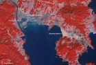
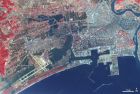
How Do Earthquakes Generate Tsunamis? By far, the most destructive tsunamis are generated from large, shallow earthquakes with an epicenter or fault line near or on the ocean floor. These usually occur in regions of the earth characterized by tectonic subduction along tectonic plate boundaries. The high seismicity of such regions is caused by the collision of tectonic plates. When these plates move past each other, they cause large earthquakes, which tilt, offset, or displace large areas of the ocean floor from a few kilometers to as much as a 1,000 km or more. The sudden vertical displacements over such large areas, disturb the ocean's surface, displace water, and generate destructive tsunami waves. The waves can travel great distances from the source region, spreading destruction along their path. For example, the Great 1960 Chilean tsunami was generated by a magnitude 9.5 earthquake that had a rupture zone of over 1,000 km. Its waves were destructive not only in Chile, but also as far away as Hawaii, Japan and elsewhere in the Pacific. It should be noted that not all earthquakes generate tsunamis. Usually, it takes an earthquake with a Richter magnitude exceeding 7.5 to produce a destructive tsunami. ��Х��һ�־���ǿ���ƻ����ĺ��ˡ�ˮ�µ��𡢻�ɽ������ˮ�����ݺͻ��µȴ�ػ����������Х�� ������ʱ�����ز㷢�����ѣ����ֵز������Ȼ���������³����ɴ���ɴӺ������������ˮ�㷢�����ҡ������������֡���������ƽ���������ĺ��˴�һ��������һ��ֻ�ں��渽��������漰����Ȳ������������ˮ��˥���ܿ졣��������ĺ�ˮ�����������ǴӺ�����������ˮ��IJ����������������������ˡ���Хʱ����Ŀ��κ��ˣ��߶ȿɴ�10��������ʮ�ײ��ȣ��γɡ�ˮǽ�������⣬��Х�����ܴɴ�����ǧ�����������ʧ��С����������ԭ�������Х���ﰶ�ߣ���ˮǽ���ͻ����½�أ������������ͲƲ����������в�� 1.the encyclopedia of earth. 2.�ٶ�֪����
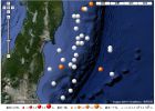
�Ͳ����¼����Ƿ���6.2������ δ������ХԤ�� ��Դ���»��� 2010��03��21��00:46 �����»���Ϥ��3��21�յ�Ͳ����¼����Ǻ���ʱ��21���賿��������6��2������Ŀ ǰ�������йط���û�з�����Х������ �������������ʿ�̽��˵����������λ�ھ�Ͳ����¼����Ƕ����²��еߵ��������Ա�95 ���ﴦ������Դ���Ϊ423��� �������������ĵ�̫ƽ��ХԤ������û�о���ε�����Х������ �����Ͳ����¼����ǵش���½��齻�紦����һ������Ƶ���ش��� http://news.sohu.com/20100321/n270974276.shtml Recent Earthquakes 03/20/2010 M 5.6, Cuba region 03/20/2010 M 5.1, south of the Aleutian Islands 03/20/2010 M 6.2, New Ireland region, Papua New Guinea 03/18/2010 M 5.6, south of the Fiji Islands 03/18/2010 M 5.5, off the west coast of the South Island of New Zealand http://www.iris.edu/hq/audience/public/earthquakes
Terra: Tale of the Earth: Four Events That Changed the World ���� Richard Hamblyn ������ Picador (��װ��2009��10��5�ճ���) ҳ�� 268 ҳ ���� 11.81 ISBN 978-0330490733 �ҿ�ʼ���Ȿ���ʱ����̫�Ӹ۵���ոշ������������һ��ʱ�������ĺ��ձ��ȵ��Ѿ�����������������ĺ�Х��������������Ȼ�ֺ�����ʾ���������ֺ������;����ϵĽ�չ�Ͳ��㣬���������ø�������ʵ���塣 �� Terra: Tales of the Earth һ���У����� Richard Hamblyn ���ù�ϣ���˵��Ĵ�Ԫ��(����������ˮ)���ۣ��ع���������ʷ������Ӱ���ش����Ȼ�ֺ���1755����˹�������1783��ŷ�������������� ����1883��ӡ��Krakatau��ɽ������1946�������ĺ�Х�� ���߰���ʷ�������ѧ���������һ�𣬼��������������������ֺ�����ʱ�ľ����ֻ����൱��ƪ�������ֺ�������ԭ�͵�ʱ�����������ֺ���Ŭ�������������˼���ǣ��������ͨ�����ֺ����о�����ʶ��Ȼ�������Լ��� 1755����˹������𣬼�����֮�����ĺ�Х�ͻ��֣��õ�������Ի͵Ľ�������һ������˹�����ؽ�ʱ���ڷ��ݵػ����ֵ�����϶������ȡ�˽�ѵ�������Ϊ��Ҫ�Ŀ��ǡ�������ѧ�ұ������������ֶ�1783������ŷ�ĸ����������о����� һ�η�����Ȼ�ֺ�(�����Ļ�ɽ����)�Ե���������������ɵij���Ӱ�죬��һ������100����ٴεõ�֤ʵ�� ���𡢻�ɽ����Х����Щ���ǵ����˶��IJ������������ơ�ĿǰҲ����Ԥ�⡣�ȫ��������Զ���ֺ�Ƶ���������������˿ڵ���������һ�취��ò���ʵ���������������ģ�����ƽʱ����Ӧ����ʩ�����������Ԥ���ȷ�ԡ� ���ֺ�Ԥ���ϣ���Х������һ���ܺõ����ӡ��ɺ����������ĺ�Х��������Ҫ�ص㣺��һ�Ǻ�Х���Դ�Խ���ﺣ�������������ֱ������½�أ��Ȿ������ д��1946�������ĺ�Х������̫ƽ����3700������İ����꺣����������ģ��ڶ������ں���Ĺ�������Х�ٶ��ٿ�(����800����ʱ�ٴ�Խ̫ƽ ��)��Ҳ�ܸ�Զ����������Сʱ��ʱ������������̫ƽ��Х����ϵͳ��������1946�������ĺ�Х���������ģ���2004��ӡ�ảХ֮����һϵͳ �Ѿ�������ӡ��������й����� ����ָ�����ڷ�����Х�У����������������ͬ����Ҫ��1960����������������ķ����˺�Х�����������ؾ����16��ǰ�ĺ�Х�����Ѿ���Į���� �����������κ�Х����ɢ����ʱ���ٴ������Ա��������2004��ӡ�ảХ�У���������һ����ѧ�˺�Х֪ʶ�ij������������������ùݵ��˵Ĺ��¡�����Ȼ ���˽⣬���������ұ�������㡣 �Ķ��ʼǣ� What Im Reading: Richard Hamblyns Terra
 ��ǩ: ��Х
![[ת��]������ȡ ���� �ձ�����������ԭ����](http://image.sciencenet.cn/album/201103/20/145756v2p0a9vhabrv2ze2.jpg.thumb.jpg)