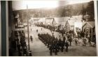
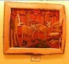
Skagway 的 Museum of Alaskan History 黄安年文 黄安年的博客 /2011 年 10 月 26 日 ( 美东时间 ) 发布 在阿拉斯加的 Skagway ,还有一座面积不大但内容丰富的具有浓厚本土色彩的 Museum of Alaskan History , 我们用半个小时光景在 24 日参观浏览。照片 28 张是即时拍摄的。 *************** Corrington's Museum of Alaskan History The Corrington’s Museum of Alaskan History is a well known tourist destination in Skagway, Alaska. It was founded by Dennis Corrington and features several walrus tusks. The Corrington’s Museum of Alaskan History sticks to its name and delivers its promise. It does tell of the state’s local history, in quite an unusual manner, however. Because unlike other museums, this one tells the tale through the walrus scrimshaw tusks, which, as of the last count amounts up to more than 40. If this is not impressive enough, the access to the Corrington’s Museum of Alaskan History is also for free. There are also other exhibits, a gift show with tons of beautiful items, and a bright flower garden outside. It is closed during the winter season and its hours depend on the cruise ships that dock in the area. http://www.cityprofile.com/alaska/corringtons-museum-of-alaskan-history.html ******************** Corrington's Alaskan Ivory and Museum is an outstanding private collection that spans the long and surprising history of Alaska that charges no admission fee. It is located at Fifth and Broadway at the far end of the "Old Town" tourist area. It would be tempting to walk quickly through this small area at the back of the store but take... http://www.tripadvisor.com/Attraction_Review-g60877-d288270-Reviews-Corrington_s_Museum_of_Alaskan_History-Skagway_Alaska.html
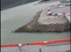
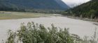
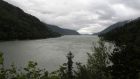
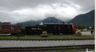
Skagway Taiya River 畔百多年前 淘金热和铁路运输遗址 黄安年文 黄安年的博客 /2011 年 10 月 25( 美东时间 ) 发布 8 月 24 日 , 我们在阿拉斯加边城 Skagway 风景秀丽的 Taiya River 游览 ,走 Taiya Inlet 沿 Taiya River 到 Dyea 一线。 这里在 100 多 年前曾经是淘金热和铁路运输线的繁忙地段,照片 24 张是 即时拍摄的。 ************************** The Taiya Inlet is part of the upper Lynn Canal located in the U.S. state of Alaska . The Taiya Inlet is an estuary which lies in a deep valley, with Skagway, Alaska at its north end and the remainder of the Lynn Canal at its south end. Contents · 1 History · 2 Taiya Inlet Winds · 3 Current status · 4 References History The Taiya Inlet received its name in 1868. Taiya was derived from the Tlingit term tayee , which means beneath or underneath . It was also called Dayday Inlet and Dejah Inlet but the latter two names fell out of favor. The Taiya Inlet was an important waterway during the Klondike Gold Rush offering passage to the deep-water port of Skagway and, by smaller boat (due to sediment from the Taiya River ), the now- ghost town of Dyea . These two boom towns were gateways to the respective White Pass and Chilkoot trails. Taiya Inlet Winds The winds in the Taiya Inlet are frequently diverted from their true courses by the mountains surrounding the valley in which the inlet lies. These diverted winds in the Taiya Inlet are also frequently more turbulent than the winds over the remainder of the Lynn Canal. The Tlingits believed that the turbulent winds in the Taiya Inlet were under the control of an ill-tempered spirit known as “Kanuga.” The spirit “Kanuga” is supposedly embodied as a “rock” near the north end of the Taiya Inlet. (This “rock” is apparently Face Mountain, and the spirit is now apparently called “Kanagoo.”) Generally, the Tlingits had separate names for winds that are diverted from their true courses by mountains and valleys (as the Taiya Inlet winds are). The name Skagway is derived from the Tlingit term shgagwèi , which refers to these turbulent winds in the Taiya inlet, and to the rough seas in the inlet created by these winds. Current status Currently the Taiya Inlet is used for marine transporatation (such as the Alaska Marine Highway ) and recreation such as fishing. The Taiya Inlet Watershed Council is also dedicating to its preservation. References 1. ^ Twitchell, Lance A. (2005). Lingít Dictionary . Troubled Raven Productions. , at pp. 1-43 ( tayee ), 2-6 ( beneath ), 2-62 ( underneath ). 2. ^ Krause, Aurel , and Erna Gunther (translator) (1956). The Tlingit Indians . University of Washington Press. , at pp. 185, 251. 3. ^ Emmons, George Thornton , and Frederica de Laguna (editor) (1991). The Tlingit Indians . University of Washington Press. , at page 427. 4. ^ In the past, it had been postulated that skagway or shgagwèi means home of xóon (the north wind) . However, home of the north wind would be xóonani . Furthermore, Hoonah, Alaska is indirectly named after xóon . Coordinates : 59°22′24″N 135°22′10″W / 59.37333°N 135.36944°W / 59.37333; -135.36944 This article about a location in the Haines Borough, Alaska is a stub . You can help Wikipedia by expanding it . v · d · e This article about a location in the Municipality of Skagway Borough, Alaska is a stub . You can help Wikipedia by expanding it . http://en.wikipedia.org/wiki/Taiya_Inlet ************* Transport corridor From Wikipedia, the free encyclopedia Jump to: navigation , search This article does not cite any references or sources . Please help improve this article by adding citations to reliable sources . Unsourced material may be challenged and removed . (December 2009) The M1 Motorway was built alongside the West Coast Main Line in Northamptonshire . A transportation corridor is a (generally linear) tract of land in which at least one main line for transport, be it road, rail or canal, has been built. Often new transport lines are built alongside existing ones to minimize the area affected by pollution. http://en.wikipedia.org/wiki/Transport_corridor
Skagway Chilkoot Trail 途中 Taiya River 上风光 黄安年文 黄安年的博客 /2011 年 10 月 24 日 ( 美东时间 ) 发布 8 月 24 日 , 我们在阿拉斯加边城 Skagway 逗留期间,因大雾汽车无法抵达加拿大边境而改变计划 , 走 Chilkoot Trail 游览, 途经风景秀丽的 Taiya River , 这里在 100 年前曾经是淘金热和铁路运输线的繁忙地段,我们河湖边在摄影留念。照片 13 张为即时拍摄的, 其中 一张是吕启祥和司机的合影。 ********************** DYEA The southern terminus of the Chilkoot Trail (where 95% of backpackers choose to begin their journey) is nine miles north of Skagway on the Dyea Road. The trailhead is on the right side of the road just before you reach the Taiya River. LAKE BENNETT The White Pass and Yukon Railroad (907) 983-2217 is the best source of transportation to the northern terminus, which is located in the remote town of Bennett (which has no services, and isn ’ t really a functioning town anymore. In fact, the train station and the church are the only buildings in Bennett). One-way tickets are available for around $60 for adults (and about $30 for kids), but make sure you book passage in advance. The train can fill-up quickly during peak backpacking season. Skagway is the closest town to Dyea. It can be reached easily by either air or boat from Juneau. We originally planned on using the Alaskan Marine Highway Ferry System, but they made constant changes to their schedule and we eventually cancelled the reservation and used the Skagway Air Service 907-983-2218 instead (which was about $150 per person, but was very scenic and saved us a ton of time.) Total Hike Distance: 33.00 miles Hike Difficulty: Very Difficult Permit Required: Yes Hike Starts: Dyea Hike Ends: Lake Bennett Trails Used: The Chilkoot Trail Hike Type: One-Way, Shuttle Hike Back Country Campsites: Yes Back Country Water Sources: Streams, Rivers, Lakes, Snow Management: National Park Service Contact Information: Klondike Gold Rush National Park National Forest Service/Parks Canada Park Address/Phone Number: P.O. Box 517, Skagway, AK 99840 (907) 983-2921 Best Season: Summer, Fall Users: Hikers Hike Summary: The Chilkoot Trail is a walk back in time. It follows the trail the stampeders used to reach the Yukon River and float their provisions to the gold fields of the Klondike. Many artifacts from the 1890 ’ s still litter the trail, and there is great diversity along the way: swamps, desert, snowy mountain passes, lush canyons, and alpine lakes. The Chilkoot has it all, and on the 33+ miles of trail you'll cross from Alaska into the Yukon Territory over the Chilkoot Pass and eventually wind your way into British Columbia. The return trip to Skagway is equally impressive, and you'll ride on a historic rail line that is one of the most scenic in the world. If you seek adventure, great scenery, and history, you ’ ll love the Chilkoot. Road Conditions: Primary Paved Roads, Maintained Gravel or Dirt Roads http://www.yourhikes.com/hikepages/HikePage.aspx?HikeID=27
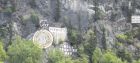
阿拉斯加 Skagway 山坡上石刻 Kirmse Curios 有待厘清 黄安年文 黄安年的博客 /2011 年 10 月 22 日 ( 美动时间 ) 发布 8 月 24 日 , 我们在阿拉斯加 Skagway 市区浏览,看到山坡上的石刻十分醒目,上面刻有 V 的字样,并有罗马时针指向 8 : 17 分钟,右下放还刻有 Moes Frontier Bar 的字样, 问了好多人 , 不解其意, 一种说法是商业广告, 如果真是商业广告也是别出心裁的。 照片 5 张是 24 日拍摄的。 附近网上介绍: *************************** Kirmse was a jeweler who brought his own gold with him to the Klondike. He barged in cantelopes and sold them to scurvey-ridden, but newly wealthy, stampeders for $50 a lope (he got $25 for the rotten ones). We were told to keep in mind this was at a time when a fancy meal in San Francisco ran you about a quarter, so that was a good move on Kirmse's part, wouldn't you say? He used his new wealth to open up shop in Skagway. Pete told us he was actually a very skilled artisan and jeweler, but you won't find any of his award-winning work because he favored a symbol in his art that unfortunately was adopted by the Nazi party in the 1940s. http://www.rvfhu.com/eblog/travel-blog/200905/
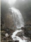
阿拉斯加 Skagway 美加边界途中眺望 Goat Lake 瀑布留影 黄安年文 黄安年的博客 /2011 年 10 月 21 日 ( 美东时间 ) 发布 8 月 24 日抵达 Skagway 后 , 我们决定租用出租汽车由专任司机开车前往在 Skagway 的美加边境,途中经过 Goat Lake 的瀑布前停留片刻,摄影留念。介绍称:“ Goat Lake is a place of kind Lake belonging to the County of Skagway . The closest populated place is that of Skagway that is 10.98 miles far from Goat Lake. Goat Lake is also 11.02 miles far from the closest airport or heliport, the Skagway Airport .” http://usa.indettaglio.it/eng/02/230/1422195.html 附照片 8 张是在抵达 Goat Lake 时拍摄的。另一张是从网上下载的。
 标签: Skagway