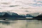
了解今日阿拉斯加 黄安年文 黄安年的博客 /2011 年 9 月 21 日 ( 美东时间 ) 发布 对于美国第 49 州阿拉斯加, 我们过去知之甚少, 而今了解甚微。这个被称为 最后的边疆( The Last Frontier )、午夜阳光之地( The Land of the Midnight Sun )之州,还在 144 年前的 1867 年 3 月 30 日,美国乘俄罗斯准备放弃阿拉斯加的时机,与俄国签订了购买阿拉斯加的条约,该地区共面积 943 713 平方公里 , 支付 720 万美元 , 合一美元购得 0.13 平方公里的土地。 , 全美 第 1 名 , 比中国的新疆维吾尔自治区还大 50000 多平方公里。 这块当年被一些人称为西华德的“大冰山”、“北极熊公园”,指责西华德是“蠢货”的阿拉斯加 位于美国的西北部,是(美国领土范围内靠北极最近的一块陆地,几乎有半年的时间是漫长的黑夜,半年的时间过太阳不落的白昼。冬天冰雪封杀道路,当地居民皆蜷缩在屋,过着类似北极熊冬眠式的生活。一年之中只有短短的三、四个月春暖花开,适合旅游。每当来自 世界各地 的游客蜂拥而至的时候,当地人就必须抓紧这段宝贵的黄金时刻,挣够足以维持他们一年开销的费用。见下介绍 ),今天却成了美国经济增长和可持续发展的战略要地。 就自然资源与环境的保护、全球战略地位而言 , 阿拉斯加的作用是不言而喻的 , 今天谁也不会再谈购买阿拉斯加是什么愚蠢之举,而深感当年的购买实在是前瞻性明智之举。 这次阿拉斯加之行 , 使得我有机会目睹阿拉斯加这块风水宝地 , 《生气蓬勃的阿拉斯加》录像片更把我们引入阿拉斯加的神奇风光中 , 今天像阿拉斯加那么大的自然保护区在世界上是独一无二的。 我们走进的阿拉斯加仅仅是整个阿拉斯加西南临近加拿大的很小很小的一部分 , 并不代表阿拉斯加的整体 , 却是旅游景点的一个缩影。 下面: 我们只要看看几个基本的数据就可以对今日 阿拉斯加在今日美国和世界发展中的地位较为清楚了。 * 占有美国陆地面积的 1/5 ( 586 , 412 平方英里), 东西长 2400 英里 , 南北长 1420 英里。 * 美国 20 座最高山峰中有 17 座在阿拉斯加。有 19 座山峰超高 14000 英尺, 北美最高峰 Mt. McKinley 在阿拉斯加境内。 *Yukon River 长约 2000 英里 ,1/3 在美国境内。阿拉斯加拥有 3000 多条河流, 超过上百万的湖泊, 最大的湖泊 Iliamna Lake 流域面积超过 1000 平方英里。 * 冰川活动超过世界其他的居住地区。 最大冰川 Malaspina 占有 850 平方公英里。 *2010 年人口统计 71 万。 * 阿拉斯加州拥有 70 多座潜在的 活火山 。最近一个世纪以来最剧烈的火山喷发是在 1912 年 NOVARUPTA 火山喷发。 照片 9 张 , 拍地阿拉斯加地图。 *************** Alaska From Wikipedia, the free encyclopedia Jump to: navigation , search This article is about the U.S. state of Alaska. For other uses, see Alaska (disambiguation) . "Alaskan" redirects here. For other uses, see Alaskan (disambiguation) . State of Alaska Flag Seal Nickname(s) : The Last Frontier Motto(s) : North to the Future Official language(s) None Spoken language(s) English 89.7%, Native North American 5.2%, Spanish 2.9% Demonym Alaskan Capital Juneau Largest city Anchorage Area Ranked 1st in the U.S. - Total 663,268 sq mi (1,717,854 km 2 ) - Width 2,261 miles (3,639 km) - Length 1,420 miles (2,285 km) - % water 13.77 - Latitude 51°20'N to 71°50'N - Longitude 130°W to 172°E Population Ranked 47th in the U.S. - Total 710,231 (2010) 626,932 (2000) - Density 1.03/sq mi (0.4/km 2 ) Ranked 50th in the U.S. - Median income US$64,333 (4th) Elevation - Highest point Mount McKinley 20,320 ft (6,193.7 m) - Mean 1900 ft (580 m) - Lowest point Sea level 0 ft (0 m) Before statehood Alaska Territory Admission to Union January 3, 1959 (49th) Governor Sean Parnell (R) Lieutenant Governor Mead Treadwell (R) Legislature Alaska Legislature - Upper house Senate - Lower house House of Representatives U.S. Senators Lisa Murkowski (R) Mark Begich (D) U.S. House delegation Don Young (R) ( at-large ) ( list ) Time zones - east of 169° 30' Alaska : UTC -9/ DST -8 - west of 169° 30' Aleutian : UTC-10/ DST -9 Abbreviations AK US-AK Website alaska.gov Alaska i / ə ˈ l s k ə / is the largest state in the United States by area. It is situated in the northwest extremity of the North American continent, with Canada to the east, the Arctic Ocean to the north, and the Pacific Ocean to the west and south, with Russia further west across the Bering Strait . Approximately half of Alaska's 710,231 residents (as per the 2010 United States Census ) live within the Anchorage metropolitan area . Alaska is the least densely populated state of the U.S. Alaska was purchased from the Russian Empire on March 30, 1867, for $7.2 million ($113 million in today's dollars) at about two cents per acre ($4.74/km²). The land went through several administrative changes before becoming an organized (or incorporated) territory on May 11, 1912, and the 49th state of the U.S. on January 3, 1959. The name "Alaska" (Аляска) was already introduced in the Russian colonial period, when it was used only for the peninsula and is derived from the Aleut alaxsxaq , meaning "the mainland" or more literally, "the object towards which the action of the sea is directed". It is also known as Alyeska , the "great land", an Aleut word derived from the same root. Contents · 1 Geography o 1.1 Regions § 1.1.1 South Central § 1.1.2 Southeast § 1.1.3 Interior § 1.1.4 Southwest § 1.1.5 North Slope § 1.1.6 Aleutian Islands o 1.2 Natural features o 1.3 Land ownership o 1.4 Climate · 2 History o 2.1 Alaska natives o 2.2 Colonization o 2.3 U.S. Territory o 2.4 Statehood · 3 Demographics o 3.1 Race and ancestry o 3.2 Languages o 3.3 Religion · 4 Economy o 4.1 Energy § 4.1.1 Permanent Fund o 4.2 Cost of living o 4.3 Agriculture · 5 Transportation o 5.1 Roads o 5.2 Rail o 5.3 Marine transport o 5.4 Air transport o 5.5 Other transport · 6 Law and government o 6.1 State government o 6.2 State politics o 6.3 Taxes o 6.4 Federal politics · 7 Cities, towns and boroughs · 8 Education · 9 Public health and public safety · 10 Culture o 10.1 Music o 10.2 Movies filmed in Alaska · 11 State symbols · 12 See also · 13 References · 14 External links Geography Main article: Geography of Alaska Wikisource has original text related to this article: Alaska Alaska has a longer coastline than all the other U.S. states combined. It is the only non- contiguous U.S. state on continental North America; about 500 miles (800 km) of British Columbia (Canada) separate Alaska from Washington state . Alaska is thus an exclave of the United States. It is technically part of the continental U.S. , but is often not included in colloquial use; Alaska is not part of the contiguous U.S., often called "the Lower 48 . The capital city, Juneau , is situated on the mainland of the North American continent, but is not connected by road to the rest of the North American highway system. The state is bordered by the Yukon Territory and British Columbia in Canada, to the east, the Gulf of Alaska and the Pacific Ocean to the south, the Bering Sea , Bering Strait , and Chukchi Sea to the west and the Arctic Ocean to the north. Alaska's territorial waters touch Russia's territorial waters in the Bering Strait, as the Russian Big Diomede Island and Alaskan Little Diomede Island are only 3 miles (4.8 km) apart. With the extension of the Aleutian Islands into the eastern hemisphere, it is technically both the westernmost and easternmost state in the United States, as well as also being the northernmost. Alaska's size compared with the 48 contiguous states . Alaska is the largest state in the United States in land area at 586,412 square miles (1,518,800 km 2 ), over twice the size of Texas, the next largest state. Alaska is larger than all but 18 sovereign countries. Counting territorial waters, Alaska is larger than the combined area of the next three largest states: Texas, California, and Montana . It is also larger than the combined area of the 22 smallest U.S. states. Regions There are no officially defined borders demarcating the various regions of Alaska, but there are six generally accepted regions: South Central Main article: South Central Alaska The most populous region of Alaska, containing Anchorage , the Matanuska-Susitna Valley and the Kenai Peninsula . Rural, mostly unpopulated areas south of the Alaska Range and west of the Wrangell Mountains also fall within the definition of Southcentral, as well as the Prince William Sound area and the communities of Cordova and Valdez . Southeast Main article: Southeast Alaska Also known as the Panhandle, this is the region of Alaska closest to the rest of the United States, and hence was where most initial non-Native settlement occurred following the Alaska Purchase . It contains the state capital, Juneau, the former capital, Sitka , and the large town of Ketchikan . The road systems leading from these cities are strictly local; no roads connect these communities to each other or any other communities apart from their own suburbs. The region is dominated by the Alexander Archipelago as well as the Tongass National Forest , the largest national forest in the United States. Interior Main article: Alaska Interior Mount McKinley is both the highest peak in Alaska and in all of North America. The largest region of Alaska, much of it uninhabited wilderness. Fairbanks is the only community of any significant size. Small towns and Native villages are scattered throughout, mostly along the highway and river systems. Denali National Park and Preserve is located here, home to Mount McKinley (also widely known by its local name of Denali), the highest point in North America. Southwest Main article: Southwest Alaska Grizzly bear fishing for salmon at Brooks Falls . A sparsely inhabited region stretching some 500 miles (800 km) inland from the Bering Sea. Most of the population lives along the coast. Kodiak Island is also located in Southwest. The massive Yukon–Kuskokwim Delta , one of the largest river deltas in the world, is here. Portions of the Alaska Peninsula are considered part of Southwest, with the remaining portions included with the Aleutian Islands (see below). North Slope Main article: Alaska North Slope The North Slope is mostly tundra peppered with small villages. The area is known for its massive reserves of crude oil, and contains both the National Petroleum Reserve–Alaska and the Prudhoe Bay Oil Field . Barrow , the northernmost city in the United States, is located here. The Northwest Arctic area , anchored by Kotzebue and also containing the Kobuk River valley, is often regarded as being part of this region. However, the respective Inupiat of the North Slope and of the Northwest Arctic seldom think of themselves as one. Aleutian Islands Main article: Aleutian Islands More than 300 small, volcanic islands make up this chain, which stretches over 1,200 miles (1,900 km) into the Pacific Ocean. The International Date Line was drawn west of 180° to keep the whole state, and thus the entire North American continent, within the same legal day. However, because some of these islands fall in the Eastern Hemisphere, this makes Alaska the northernmost, easternmost and westernmost state in the union, with the southernmost state being Hawaii. Two of the islands, Attu and Kiska , were occupied by Japanese forces during World War II. Natural features Augustine Volcano erupting on January 12, 2006. With its myriad islands, Alaska has nearly 34,000 miles (54,720 km) of tidal shoreline. The Aleutian Islands chain extends west from the southern tip of the Alaska Peninsula . Many active volcanoes are found in the Aleutians and in coastal regions. Unimak Island , for example, is home to Mount Shishaldin , which is an occasionally smoldering volcano that rises to 10,000 feet (3,048 m) above the North Pacific. It is the most perfect volcanic cone on Earth, even more symmetrical than Japan's Mount Fuji . The chain of volcanoes extends to Mount Spurr , west of Anchorage on the mainland. Geologists have identified Alaska as part of Wrangellia , a large region consisting of multiple states and Canadian provinces in the Pacific Northwest which is actively undergoing continent building . One of the world's largest tides occurs in Turnagain Arm , just south of Anchorage – tidal differences can be more than 35 feet (10.7 m). (Many sources say Turnagain has the second-greatest tides in North America, but several areas in Canada have larger tides.) Main article: List of lakes in Alaska Alaska has more than three million lakes. Marshlands and wetland permafrost cover 188,320 square miles (487,747 km 2 ) (mostly in northern, western and southwest flatlands). Glacier ice covers some 16,000 square miles (41,440 km 2 ) of land and 1,200 square miles (3,110 km 2 ) of tidal zone. The Bering Glacier complex near the southeastern border with Yukon covers 2,250 square miles (5,827 km 2 ) alone. With over 100,000, Alaska has half of the world's glaciers. Land ownership Alaska has more public land owned by the federal government than any other state. According to an October 1998 report by the United States Bureau of Land Management , approximately 65% of Alaska is owned and managed by the U.S. federal government as public lands, including a multitude of national forests , national parks, and national wildlife refuges . Of these, the Bureau of Land Management manages 87 million acres (35 million hectares), or 23.8% of the state. The Arctic National Wildlife Refuge is managed by the United States Fish and Wildlife Service . It is the world's largest wildlife refuge, comprising 16 million acres (6.5 million hectares). Of the remaining land area, the state of Alaska owns 101 million acres (41 million hectares); its entitlement under the Alaska Statehood Act . A portion of that acreage is occasionally ceded to organized boroughs, under the statutory provisions pertaining to newly-formed boroughs. Smaller portions are set aside for rural subdivisions and other homesteading-related opportunities, though these are infrequently popular due to the often remote and roadless locations. The University of Alaska , as a land grant university , also owns substantial acreage which it manages independently. Another 44 million acres (18 million hectares) are owned by 12 regional, and scores of local, Native corporations created under the Alaska Native Claims Settlement Act . Regional Native corporation Doyon, Limited often promotes itself as the largest private landowner in Alaska in advertisements and other communications. Provisions of ANCSA allowing the corporations' land holdings to be sold on the open market starting in 1991 were repealed before they could take effect. Effectively, the corporations hold title (including subsurface title in many cases, a privilege denied to individual Alaskans) but cannot sell the land. Individual Native allotments can be and are sold on the open market, however. Various private interests own the remaining land, totaling about one percent of the state. Alaska is, by a large margin, the state with the smallest percentage of private land ownership when Native corporation holdings are excluded. Climate Main article: Climate of Alaska The climate in Juneau and the southeast panhandle is a mid-latitude oceanic climate ( Kppen climate classification Cfb ) in the southern sections and a subarctic oceanic climate (Kppen Cfc ) in the northern parts. On an annual basis, the panhandle is both the wettest and warmest part of Alaska with milder temperatures in the winter and high precipitation throughout the year. Juneau averages over 50 inches (1,270 mm) of precipitation a year, while other areas receive over 275 inches (6,990 mm). This is also the only region in Alaska in which the average daytime high temperature is above freezing during the winter months. The climate of Anchorage and south central Alaska is mild by Alaskan standards due to the region's proximity to the seacoast. While the area gets less rain than southeast Alaska, it gets more snow, and days tend to be clearer. On average, Anchorage receives 16 inches (406 mm) of precipitation a year, with around 75 inches (191 cm) of snow, although there are areas in the south central which receive far more snow. It is a subarctic climate (Kppen Dfc ) due to its brief, cool summers. Barrow , known colloquially for many years by the nickname "Top of the World," is the northernmost city in the United States. The climate of Western Alaska is determined in large part by the Bering Sea and the Gulf of Alaska. It is a subarctic oceanic climate in the southwest and a continental subarctic climate farther north. The temperature is somewhat moderate considering how far north the area is. This region has a tremendous amount of variety in precipitation. An area stretching from the northern side of the Seward Peninsula to the Kobuk River valley is technically a desert, with portions receiving less than 10 inches (254 mm) of precipitation annually. On the other extreme, some locations between Dillingham and Bethel average around 100 inches (2,540 mm) of precipitation. The climate of the interior of Alaska is subarctic. Some of the highest and lowest temperatures in Alaska occur around the area near Fairbanks. The summers may have temperatures reaching into the 90s°F (the low to mid 30s °C), while in the winter, the temperature can fall below −60 °F (−51.1 °C). Precipitation is sparse in the Interior, often less than 10 inches (254 mm) a year, but what precipitation falls in the winter tends to stay the entire winter. The highest and lowest recorded temperatures in Alaska are both in the Interior. The highest is 100 °F (37.8 °C) in Fort Yukon (which is just 8 miles or 13 kilometers inside the arctic circle) on June 27, 1915, making Alaska tied with Hawaii as the state with the lowest high temperature in the United States. The lowest official Alaska temperature is −80 °F (−62.2 °C) in Prospect Creek on January 23, 1971, one degree above the lowest temperature recorded in continental North America (in Snag, Yukon, Canada ). The climate in the extreme north of Alaska is Arctic (Kppen ET ) with long, very cold winters and short, cool summers. Even in July, the average low temperature in Barrow is 34 °F (1.1 °C). Precipitation is light in this part of Alaska, with many places averaging less than 10 inches (254 mm) per year, mostly as snow which stays on the ground almost the entire year. History Main article: History of Alaska Alaska natives See also: Prehistory of Alaska A modern Alutiiq dancer in traditional festival garb Numerous indigenous peoples occupied Alaska for thousands of years before the arrival of European peoples to the area. The Tlingit people developed a matriarchal society in what is today Southeast Alaska, along with parts of British Columbia and the Yukon. Also in Southeast were the Haida , now well known for their unique arts, and the Tsimshian people, whose population were decimated by a smallpox epidemic in the 1860s. The Aleutian Islands are still home to the Aleut people's seafaring society, although they were among the first to be exploited by the Russians. Western and Southwestern Alaska are home to the Yup'ik , while their cousins the Alutiiq lived in what is now Southcentral Alaska. The Gwich’in people of the northern Interior region are primarily known today for their dependence on the caribou within the much-contested Arctic National Wildlife Refuge . The North Slope and Little Diomede Island are occupied by the widespread Inuit people. Colonization Miners and prospectors climb the Chilkoot Trail during the Klondike Gold Rush . Some researchers believe that the first Russian settlement in Alaska was established in 17th century . According to this hypothesis, in 1648 several koches of Semyon Dezhnyov 's expedition were thrown to Alaska by storm and founded this settlement. This hypothesis is based on the message of Chukchi geographer Nikolai Daurkin who had visited Alaska in 1764–1765 and reported about village on the Kheuveren river, populated by "bearded men" who "pray to the icons". Some modern reseachers associate Kheuveren with Koyuk River . It is usually assumed that the first European boat to reach Alaska was St. Gabriel under the authority of the surveyor M. S. Gvozdev and assistant navigator I. Fyodorov on August 21, 1732 during expedition of Siberian cossak A. F. Shestakov adb Belorussian explorer D. I. Pavlutsky (1729—1735) Another European contact with Alaska occurred in 1741, when Vitus Bering led an expedition for the Russian Navy aboard the St. Peter . After his crew returned to Russia with sea otter pelts judged to be the finest fur in the world, small associations of fur traders began to sail from the shores of Siberia towards the Aleutian islands. The first permanent European settlement was founded in 1784. Between 1774 and 1800 Spain sent several expeditions to Alaska in order to assert its claim over the Pacific Northwest. In 1789 a Spanish settlement and fort were built in Nootka Sound . These expeditions gave names to places such as Valdez , Bucareli Sound , and Cordova . Later, the Russian-American Company carried out an expanded colonization program during the early-to-mid-19th century. Sitka , renamed New Archangel from 1804 to 1867, on Baranof Island in the Alexander Archipelago in what is now Southeast Alaska , became the capital of Russian America and remained the capital after the colony was transferred to the United States. The Russians never fully colonized Alaska, and the colony was never very profitable. William H. Seward , the United States Secretary of State , negotiated the Alaska Purchase (also known as Seward's Folly) with the Russians in 1867 for $7.2 million. Alaska was loosely governed by the military initially, and was administered as a district starting in 1884, with a governor appointed by the president of the United States, as well as a district court headquartered in Sitka. For most of Alaska's first decade under the American flag, Sitka was the only community inhabited by American settlers. They organized a "provisional city government," which was Alaska's first city government, but not in a legal sense. Legislation allowing Alaskan communities to legally incorporate as cities did not come about until 1900, and home rule for cities was extremely limited or unavailable until statehood took effect. U.S. Territory Starting in the 1890s and stretching in some places to the early 1910s, gold rushes in Alaska and the nearby Yukon Territory brought thousands of miners and settlers to Alaska. Alaska was officially incorporated as an organized territory in 1912. Alaska's capital, which had been in Sitka until the 1900 legislation mandated its transfer to Juneau (the actual move took place in 1906, after initial questions arose), begun to take shape with the construction of the Alaska Governor's Mansion that same year. U.S. troops negotiate snow and ice during the Battle of Attu in May 1943. During World War II, the Aleutian Islands Campaign focused on the three outer Aleutian Islands – Attu , Agattu and Kiska – that were invaded by Japanese troops and occupied between June 1942 and August 1943. Unalaska /Dutch Harbor became a significant base for the U.S. Army Air Corps and Navy submariners. The U.S. Lend-Lease program involved the flying of American warplanes through Canada to Fairbanks and thence Nome; Soviet pilots took possession of these aircraft, ferrying them to fight the German invasion of the Soviet Union. The construction of military bases contributed to the population growth of some Alaskan cities. Statehood Statehood for Alaska was an important cause of James Wickersham early in his tenure as a congressional delegate. Decades later, the statehood movement gained its first real momentum following a territorial referendum in 1946. The Alaska Statehood Committee and Alaska's Constitutional Convention would soon follow. Statehood supporters also found themselves fighting major battles against political foes, mostly in the U.S. Congress but also within Alaska. Statehood was approved by Congress on July 7, 1958. Alaska was officially proclaimed a state on January 3, 1959. On April 27, 1964, the massive " Good Friday Earthquake " killed 133 people and destroyed several villages and portions of large coastal communities, mainly by the resultant tsunamis and landslides. It was the third most powerful earthquake in the recorded history of the world, with a moment magnitude of 9.2. It was over one thousand times more powerful than the 1989 San Francisco earthquake . The time of day (5:36 pm), time of year and location of the epicenter were all cited as factors in potentially sparing thousands of lives, particularly in Anchorage. The 1968 discovery of oil at Prudhoe Bay and the 1977 completion of the Trans-Alaska Pipeline led to an oil boom. Royalty revenues from oil have funded large state budgets from 1980 onward. That same year, not coincidentally, Alaska repealed its state income tax. In 1989, the Exxon Valdez hit a reef in the Prince William Sound , spilling over 11,000,000 US gallons (42,000 m 3 ) of crude oil over 1,100 miles (1,600 km) of coastline. Today, the battle between philosophies of development and conservation is seen in the contentious debate over oil drilling in the Arctic National Wildlife Refuge . Demographics Main article: Demographics of Alaska Historical populations Census Pop. %± 1880 33,426 — 1890 32,052 −4.1% 1900 63,592 98.4% 1910 64,356 1.2% 1920 55,036 −14.5% 1930 59,278 7.7% 1940 72,524 22.3% 1950 128,643 77.4% 1960 226,167 75.8% 1970 300,382 32.8% 1980 401,851 33.8% 1990 550,043 36.9% 2000 626,932 14.0% 2010 710,231 13.3% 1930 and 1940 censuses taken in preceding autumn Sources: 1910–2010 The United States Census Bureau , as of July 1, 2008, estimated Alaska's population at 686,293, which represents an increase of 59,361, or 9.5%, since the last census in 2000. This includes a natural increase since the last census of 60,994 people (that is 86,062 births minus 25,068 deaths) and a decrease due to net migration of 5,469 people out of the state. Immigration from outside the U.S. resulted in a net increase of 4,418 people, and migration within the country produced a net loss of 9,887 people. In 2000 Alaska ranked the 48th state by population, ahead of Vermont and Wyoming (and Washington D.C.). Alaska is the least densely populated state, and one of the most sparsely populated areas in the world, at 1.0 person per square mile (0.42/km²), with the next state, Wyoming, at 5.1 per square mile (1.97/km²). Alaska is the largest U.S. state by area , and the sixth wealthiest (per capita income). As of January 2010, the state's unemployment rate is 8.5%. Race and ancestry According to the 2010 U.S. Census , Alaska had a population of 710,231. In terms of race and ethnicity, the state was 66.7% White (64.7% Non-Hispanic White Alone), 14.8% American Indian and Alaska Native, 5.4% Asian, 3.3% Black or African American, 1.0% Native Hawaiian and Other Pacific Islander, 1.6% from Some Other Race, and 7.3% from Two or More Races. Hispanics or Latinos of any race made up 5.5% of the population. Languages According to the 2005–2007 American Community Survey, 84.7% of people over the age of five speak only English at home. About 3.5% speak Spanish at home. About 2.2% speak another Indo-European language at home and about 4.3% speak an Asian language at home. And about 5.3% speak other languages at home. A total of 5.2% of Alaskans speak one of the state's 22 indigenous languages , known locally as "native languages". These languages belong to two major language families: Eskimo–Aleut and Na-Dene . As the homeland of these two major language families of North America, Alaska has been described as the crossroads of the continent, providing evidence for the recent settlement of North America by way of the Bering land bridge . Religion St. Michael's Russian Orthodox Cathedral in Sitka . Alaska has been identified, along with Pacific Northwest states Washington and Oregon, as being the least religious in the U.S. According to statistics collected by the Association of Religion Data Archives, about 39% of Alaska residents were members of religious congregations. Evangelical Protestants had 78,070 members, Roman Catholics had 54,359, and mainline Protestants had 37,156. After Catholicism, the largest single denominations are The Church of Jesus Christ of Latter-day Saints with 30,169, and Southern Baptists with 22,959. The large Eastern Orthodox (with 49 parishes and up to 50,000 followers) population is a result of early Russian colonization and missionary work among Alaska Natives. In 1795, the First Russian Orthodox Church was established in Kodiak . Intermarriage with Alaskan Natives helped the Russian immigrants integrate into society. As a result, an increasing number of Russian Orthodox churches gradually became established within Alaska. Alaska also has the largest Quaker population (by percentage) of any state. In 2009 there were 6,000 Jews in Alaska (for whom observance of the mitzvah may pose special problems ). Estimates for the number of Alaskan Muslims range from 2,000 to 5,000. In 2010, the local Muslim community broke ground on the first mosque in the state. Alaskan Hindus often share venues and celebrations with members of other religious communities including Sikhs and Jains . Economy Main article: Economy of Alaska The Trans-Alaska Pipeline transports oil, Alaska's most financially important export, from the North Slope to Valdez . Pertinent are the heat pipes in the column mounts, which disperses heat upwards and prevents melting of permafrost . The 2007 gross state product was $44.9 billion, 45th in the nation. Its per capita personal income for 2007 was $40,042, ranking 15th in the nation. The oil and gas industry dominates the Alaskan economy, with more than 80% of the state's revenues derived from petroleum extraction. Alaska's main export product (excluding oil and natural gas) is seafood, primarily salmon, cod, Pollock and crab. Agriculture represents only a fraction of the Alaskan economy. Agricultural production is primarily for consumption within the state and includes nursery stock, dairy products, vegetables, and livestock. Manufacturing is limited, with most foodstuffs and general goods imported from elsewhere. Employment is primarily in government and industries such as natural resource extraction, shipping, and transportation. Military bases are a significant component of the economy in both Fairbanks and Anchorage. Federal subsidies are also an important part of the economy, allowing the state to keep taxes low. Its industrial outputs are crude petroleum, natural gas, coal, gold, precious metals, zinc and other mining, seafood processing, timber and wood products. There is also a growing service and tourism sector. Tourists have contributed to the economy by supporting local lodging. Energy See also: Natural gas in Alaska and Energy law#Alaska law Alaska oil reserves peaked in 1978 and have declined 60% thereafter. Alaska has vast energy resources. Major oil and gas reserves are found in the Alaska North Slope (ANS) and Cook Inlet basins. According to the Energy Information Administration , Alaska ranks second in the nation in crude oil production. Prudhoe Bay on Alaska's North Slope is the highest yielding oil field in the United States and on North America, typically producing about 400,000 barrels per day (64,000 m 3 /d). The Trans-Alaska Pipeline can transport and pump up to 2.1 million barrels (330,000 m 3 ) of crude oil per day, more than any other crude oil pipeline in the United States. Additionally, substantial coal deposits are found in Alaska's bituminous, sub-bituminous, and lignite coal basins. The United States Geological Survey estimates that there are 85.4 trillion cubic feet (2,420 km 3 ) of undiscovered, technically recoverable gas from natural gas hydrates on the Alaskan North Slope. Alaska also offers some of the highest hydroelectric power potential in the country from its numerous rivers. Large swaths of the Alaskan coastline offer wind and geothermal energy potential as well. Alaska oil production peaked in 1988 and has declined 65% since. Alaska's economy depends heavily on increasingly expensive diesel fuel for heating, transportation, electric power and light. Though wind and hydroelectric power are abundant and underdeveloped, proposals for state-wide energy systems (e.g. with special low-cost electric interties ) were judged uneconomical (at the time of the report, 2001) due to low ($0.50/Gal) fuel prices, long distances and low population. The cost of a US gallon of gas in urban Alaska today is usually $0.30–$0.60 higher than the national average; prices in rural areas are generally significantly higher but vary widely depending on transportation costs, seasonal usage peaks, nearby petroleum development infrastructure and many other factors. Alaska accounts for one-fifth (20 percent) of domestically produced United States oil production. Prudhoe Bay (North America's largest oil field) alone accounts for 8% of the U.S. domestic oil production. Permanent Fund The Alaska Permanent Fund is a constitutionally authorized appropriation of oil revenues, established by voters in 1976 to manage a surplus in state petroleum revenues from oil, largely in anticipation of same from the recently constructed Trans-Alaska Pipeline System . The fund was originally proposed by Governor Keith Miller on the eve of the 1969 Prudhoe Bay lease sale, out of fear that the legislature would spend the entire proceeds of the sale (which amounted to $900 million (US)) at once, and was later championed by Governor Jay Hammond and Kenai state representative Hugh Malone. It has served as an attractive political prospect ever since, diverting revenues which would normally be deposited into the general fund. The Alaska Constitution was written so as to discourage dedicating state funds for a particular purpose. The Permanent Fund has become the rare exception to this, mostly due to the political climate of distrust existing during the time of its creation. From its initial principal of $734,000, the fund has grown to $40 billion as a result of oil royalties and capital investment programs. Most if not all the principal is invested conservatively outside Alaska. This has led to frequent calls by Alaskan politicians for the Fund to make investments within Alaska, though such a stance has never really gained momentum. Starting in 1982, dividends from the fund's annual growth have been paid out each year to eligible Alaskans, ranging from an initial $1,000.00 in 1982 (equal to three years' payout, as the distribution of payments was held up in a lawsuit over the distribution scheme) to $3,269.00 in 2008 (which included a one-time $1,200.00 "Resource Rebate"). Every year, the state legislature takes out 8 percent from the earnings, puts 3 percent back into the principal for inflation proofing, and the remaining 5 percent is distributed to all qualifying Alaskans. To qualify for the Permanent Fund Dividend, one must have lived in the state for a minimum of 12 months, maintain constant residency subject to allowable absences, and not be subject to court judgments or criminal convictions which fall under various disqualifying classifications or may subject the payment amount to civil garnishment. Cost of living The cost of goods in Alaska has long been higher than in the contiguous 48 states. This has changed for the most part in Anchorage and to a lesser extent in Fairbanks, where the cost of living has dropped somewhat in the past five years. Federal government employees, particularly United States Postal Service (USPS) workers and active-duty military members, receive a Cost of Living Allowance usually set at 25% of base pay because, while the cost of living has gone down, it is still one of the highest in the country. The introduction of big-box stores in Anchorage, Fairbanks, and Juneau also did much to lower prices. Wal-Mart opened their first Anchorage store in 1993, and debuted in Fairbanks in 2004. The company currently has locations covering most of the population centers of Alaska, including Juneau, Ketchikan and Kodiak. However, rural Alaska suffers from extremely high prices for food and consumer goods, compared to the rest of the country due to the relatively limited transportation infrastructure. Many rural residents come into these cities and purchase food and goods in bulk from warehouse clubs like Costco and Sam's Club . Some have embraced the free shipping offers of some online retailers to purchase items much more cheaply than they could in their own communities, if they are available at all. Agriculture Due to the northern climate and steep terrain, relatively little farming occurs in Alaska. Most farms are in either the Matanuska Valley , about 40 miles (64 km) northeast of Anchorage , or on the Kenai Peninsula , about 60 miles (97 km) southwest of Anchorage. The short 100-day growing season limits the crops that can be grown, but the long sunny summer days make for productive growing seasons. The primary crops are potatoes, carrots, lettuce, and cabbage. The Delta Junction area, about 100 miles (160 km) southeast of Fairbanks, also has a sizable concentration of farms, which mostly lie north and east of Fort Greely . This area was largely set aside and developed under a state program spearheaded by Hammond during his second term as governor. Delta-area crops consist predominately of barley and hay. Alaska, with no counties, also lacks county fairs. However, a small assortment of state and local fairs (with the Alaska State Fair in Palmer the largest), are held mostly in the late summer. The fairs are mostly located in communities with historic or current agricultural activity, and feature local farmers exhibiting produce in addition to more high-profile commercial activities such as carnival rides, concerts and food. "Alaska Grown" is used as an agricultural slogan. Halibut is important to the state's economy as both a commercial and sport-caught fish. Alaska has an abundance of seafood, with the primary fisheries in the Bering Sea and the North Pacific, and seafood is one of the few food items that is often cheaper within the state than outside it. Many Alaskans take advantage of salmon seasons to harvest portions of their household diet while fishing for subsistence, as well as sport. This includes fish taken by hook, net or wheel. Hunting for subsistence, primarily caribou , moose , and Dall sheep is still common in the state, particularly in remote Bush communities. An example of a traditional native food is Akutaq , the Eskimo ice cream, which can consist of reindeer fat, seal oil, dried fish meat and local berries. Alaska's reindeer herding is concentrated on Seward Peninsula where wild caribou can be prevented from mingling and migrating with the domesticated reindeer. Most food in Alaska is transported into the state from "Outside" , and shipping costs make food in the cities relatively expensive. In rural areas, subsistence hunting and gathering is an essential activity because imported food is prohibitively expensive. The cost of importing food to villages begins at 7 per pound (15/kg) and rises rapidly to 50 per pound ($1.10/kg) or more. The cost of delivering a 1 US gallon (3.8 L) of milk is about $3.50 in many villages where per capita income can be $20,000 or less. Fuel cost can exceed $8.00 per gallon. Transportation Main article: Transportation in Alaska Roads Sterling Highway . See also: List of Alaska Routes Alaska has few road connections compared to the rest of the U.S. The state's road system covers a relatively small area of the state, linking the central population centers and the Alaska Highway , the principal route out of the state through Canada. The state capital, Juneau, is not accessible by road, only a car ferry, which has spurred several debates over the decades about moving the capital to a city on the road system, or building a road connection from Haines . The western part of Alaska has no road system connecting the communities with the rest of Alaska. The Susitna River bridge on the Denali Highway is 1,036 feet (316 m) long. One unique feature of the Alaska Highway system is the Anton Anderson Memorial Tunnel , an active Alaska Railroad tunnel recently upgraded to provide a paved roadway link with the isolated community of Whittier on Prince William Sound to the Seward Highway about 50 miles (80 km) southeast of Anchorage at Portage . At 2.5 miles (4.0 km) the tunnel was the longest road tunnel in North America until 2007. The tunnel is the longest combination road and rail tunnel in North America. Rail Alaska Railroad " Glacier Discovery " train. Built around 1915, the Alaska Railroad (ARR) played a key role in the development of Alaska through the 20th century. It links north Pacific shipping through providing critical infrastructure with tracks that run from Seward to Interior Alaska by way of South Central Alaska , passing through Anchorage, Eklutna , Wasilla, Talkeetna , Denali , and Fairbanks, with spurs to Whittier , Palmer and North Pole . The cities, towns, villages, and region served by ARR tracks are known statewide as "The Railbelt". In recent years, the ever-improving paved highway system began to eclipse the railroad's importance in Alaska's economy. The railroad, though famed for its summertime tour passenger service, played a vital role in Alaska's development, moving freight into Alaska while transporting natural resources southward (i.e., coal from the Usibelli coal mine near Healy to Seward and gravel from the Matanuska Valley to Anchorage). The Alaska Railroad was one of the last railroads in North America to use cabooses in regular service and still uses them on some gravel trains. It continues to offer one of the last flag stop routes in the country. A stretch of about 60 miles (100 km) of track along an area north of Talkeetna remains inaccessible by road; the railroad provides the only transportation to rural homes and cabins in the area; until construction of the Parks Highway in the 1970s, the railroad provided the only land access to most of the region along its entire route. In northern Southeast Alaska, the White Pass and Yukon Route also partly runs through the State from Skagway northwards into Canada (British Columbia and Yukon Territory), crossing the border at White Pass Summit. This line is now mainly used by tourists, often arriving by cruise liner at Skagway. It featured in the 1983 BBC television series Great Little Railways . The Alaska Rail network is not connected to Outside. In 2000, the U.S. Congress authorized $6 million to study the feasibility of a rail link between Alaska, Canada, and the lower 48. Alaska Rail Marine provides car float service between Whittier and Seattle . Marine transport Many cities, towns and villages in the state do not have road or highway access; the only modes of access involve travel by air, river, or the sea. The M/V Tustumena (named after Tustumena Glacier ) is one of the state's many ferries, providing service between the Kenai Peninsula and Kodiak Island . Alaska's well-developed state-owned ferry system (known as the Alaska Marine Highway ) serves the cities of southeast , the Gulf Coast and the Alaska Peninsula. The ferries transport vehicles as well as passengers. The system also operates a ferry service from Bellingham, Washington and Prince Rupert, British Columbia in Canada through the Inside Passage to Skagway . The Inter-Island Ferry Authority also serves as an important marine link for many communities in the Prince of Wales Island region of Southeast and works in concert with the Alaska Marine Highway. In recent years, cruise lines have created a summertime tourism market, mainly connecting the Pacific Northwest to Southeast Alaska and, to a lesser degree, towns along Alaska's gulf coast. The population of Ketchikan may rise by over 10,000 people on many days during the summer, as up to four large cruise ships at a time can dock, debarking thousands passengers. Air transport Cities not served by road, sea, or river can be reached only by air, foot, dogsled, or snowmachine accounting for Alaska's extremely well developed bush air services—an Alaskan novelty. Anchorage itself, and to a lesser extent Fairbanks, are served by many major airlines . Because of limited highway access, air travel remains the most efficient form of transportation in and out of the state. Anchorage recently completed extensive remodeling and construction at Ted Stevens Anchorage International Airport to help accommodate the upsurge in tourism (in 2000–2001, the latest year for which data is available, 2.4 million total arrivals to Alaska were counted, 1.7 million by air travel; 1.4 million were visitors). Alaska Airlines Boeing 737 airliner Regular flights to most villages and towns within the state that are commercially viable are challenging to provide, so they are heavily subsidized by the federal government through the Essential Air Service program. Alaska Airlines is the only major airline offering in-state travel with jet service (sometimes in combination cargo and passenger Boeing 737 -400s) from Anchorage and Fairbanks to regional hubs like Bethel , Nome , Kotzebue , Dillingham , Kodiak , and other larger communities as well as to major Southeast and Alaska Peninsula communities. The bulk of remaining commercial flight offerings come from small regional commuter airlines such as Era Aviation , PenAir , and Frontier Flying Service . The smallest towns and villages must rely on scheduled or chartered bush flying services using general aviation aircraft such as the Cessna Caravan , the most popular aircraft in use in the state. Much of this service can be attributed to the Alaska bypass mail program which subsidizes bulk mail delivery to Alaskan rural communities. The program requires 70% of that subsidy to go to carriers who offer passenger service to the communities. Many communities have small air taxi services. These operations originated from the demand for customized transport to remote areas. Perhaps the most quintessentially Alaskan plane is the bush seaplane. The world's busiest seaplane base is Lake Hood , located next to Ted Stevens Anchorage International Airport, where flights bound for remote villages without an airstrip carry passengers, cargo, and many items from stores and warehouse clubs. Alaska has the highest number of pilots per capita of any U.S. state: out of the estimated 663,661 residents, 8,550 are pilots, or about one in 78. Other transport Another Alaskan transportation method is the dogsled . In modern times (that is, any time after the mid-late 1920s), dog mushing is more of a sport than a true means of transportation. Various races are held around the state, but the best known is the Iditarod Trail Sled Dog Race , a 1150-mile (1850 km) trail from Anchorage to Nome (although the distance varies from year to year, the official distance is set at 1,049 miles (1,688 km)). The race commemorates the famous 1925 serum run to Nome in which mushers and dogs like Togo and Balto took much-needed medicine to the diphtheria -stricken community of Nome when all other means of transportation had failed. Mushers from all over the world come to Anchorage each March to compete for cash, prizes, and prestige. The "Serum Run" is another sled dog race that more accurately follows the route of the famous 1925 relay, leaving from the community of Nenana (southwest of Fairbanks) to Nome. In areas not served by road or rail, primary transportation in summer is by all-terrain vehicle and in winter by snowmobile or "snow machine," as it is commonly referred to in Alaska. Law and government Main article: Government of Alaska State government The center of state government in Juneau . The large buildings in the background are, from left to right: the Court Plaza Building (colloquially known as the "Spam Can" ), the State Office Building (behind), the Alaska Office Building, the John H. Dimond State Courthouse, and the Alaska State Capitol . Many of the smaller buildings in the foreground are also occupied by state government agencies. Like all other U.S. states, Alaska is governed as a republic, with three branches of government : an executive branch consisting of the Governor of Alaska and the other independently elected constitutional officers; a legislative branch consisting of the Alaska House of Representatives and Alaska Senate ; and a judicial branch consisting of the Alaska Supreme Court and lower courts. The state of Alaska employs approximately 15,000 employees statewide. The Alaska Legislature consists of a 40-member House of Representatives and a 20-member Senate . Senators serve four year terms and House members two. The Governor of Alaska serves four-year terms. The lieutenant governor runs separately from the governor in the primaries , but during the general election, the nominee for governor and nominee for lieutenant governor run together on the same ticket. Alaska's court system has four levels: the Alaska Supreme Court , the court of appeals, the superior courts and the district courts. The superior and district courts are trial courts . Superior courts are courts of general jurisdiction, while district courts only hear certain types of cases, including misdemeanor criminal cases and civil cases valued up to $100,000. The Supreme Court and the Court Of Appeals are appellate courts . The Court Of Appeals is required to hear appeals from certain lower-court decisions, including those regarding criminal prosecutions, juvenile delinquency, and habeas corpus . The Supreme Court hears civil appeals and may in its discretion hear criminal appeals. State politics Further information: Political party strength in Alaska Although Alaska entered the union as a Democratic state, since the early 1970s Alaska has been characterized as a Republican -leaning state. Local political communities have often worked on issues related to land use development, fishing, tourism, and individual rights. Alaska Natives , while organized in and around their communities, have been active within the Native corporations . These have been given ownership over large tracts of land, which require stewardship. Alaska is the only state in which possession of one ounce or less of marijuana in one's home is completely legal under state law, though the federal law remains in force. The state has an independence movement favoring a vote on secession from the United States, with the Alaskan Independence Party labeled as one of "the most significant state-level third parties operating in the 20th century". Six Republicans and four Democrats have served as governor of Alaska. In addition, Republican Governor Wally Hickel was elected to the office for a second term in 1990 after leaving the Republican party and briefly joining the Alaskan Independence Party ticket just long enough to be reelected. He subsequently officially rejoined the Republican party in 1994. Taxes To finance state government operations, Alaska depends primarily on petroleum revenues and federal subsidies. This allows it to have the lowest individual tax burden in the United States, and be one of only five states with no state sales tax , one of seven states that do not levy an individual income tax , and one of two states that has neither. The Department of Revenue Tax Division reports regularly on the state's revenue sources. The Department also issues an annual summary of its operations, including new state laws that directly affect the tax division. While Alaska has no state sales tax, 89 municipalities collect a local sales tax, from 1–7.5%, typically 3–5%. Other local taxes levied include raw fish taxes, hotel, motel, and bed-and-breakfast 'bed' taxes, severance taxes , liquor and tobacco taxes, gaming (pull tabs) taxes, tire taxes and fuel transfer taxes. A part of the revenue collected from certain state taxes and license fees (such as petroleum, aviation motor fuel, telephone cooperative) is shared with municipalities in Alaska. Fairbanks has one of the highest property taxes in the state as no sales or income taxes are assessed in the Fairbanks North Star Borough (FNSB). A sales tax for the FNSB has been voted on many times, but has yet to be approved, leading law makers to increase taxes dramatically on other goods such as liquor and tobacco. In 2008 the Tax Foundation ranked Alaska as having the 4th most "business friendly" tax policy. More "friendly" states were Wyoming , Nevada , and South Dakota . Federal politics Presidential elections results Year Republican Democratic 2008 59.49% 192,631 37.83% 122,485 2004 61.07% 190,889 35.52% 111,025 2000 58.62% 167,398 27.67% 79,004 1996 50.80% 122,746 33.27% 80,380 1992 39.46% 102,000 30.29% 78,294 1988 59.59% 119,251 36.27% 72,584 1984 66.65% 138,377 29.87% 62,007 1980 54.35% 86,112 26.41% 41,842 1976 57.90% 71,555 35.65% 44,058 1972 58.13% 55,349 34.62% 32,967 1968 45.28% 37,600 42.65% 35,411 1964 34.09% 22,930 65.91% 44,329 1960 50.94% 30,953 49.06% 29,809 In presidential elections, the state's electoral college votes have been won by the Republican nominee in every election since statehood, except for 1964. No state has voted for a Democratic presidential candidate fewer times. Alaska supported Democratic nominee Lyndon B. Johnson in the landslide year of 1964 , and the 1960 and 1968 elections were close. Since 1972 , however, Republicans have carried the state by large margins. In 2008 , Republican John McCain defeated Democrat Barack Obama in Alaska, 59.49% to 37.83%. McCain's running mate was Sarah Palin , the state's governor and the first Alaskan on a major party ticket. The Alaska Bush , central Juneau, midtown and downtown Anchorage, and the area surrounding the University of Alaska Fairbanks campus have been strongholds of the Democratic Party. Matanuska-Susitna Borough and South Anchorage typically have the strongest Republican showing. As of 2004, well over half of all registered voters have chosen "Non-Partisan" or "Undeclared" as their affiliation, despite recent attempts to close primaries. Because of its population relative to other U.S. states, Alaska has only one member in the U.S. House of Representatives . This seat is currently being held by Republican Don Young , who was re-elected to his 19th consecutive term in 2008. Alaska's At-large congressional district is currently the world's second-largest parliamentary constituency by area, behind only the Canadian territory of Nunavut . In 2008, Governor Sarah Palin became the first Republican woman to run on a national ticket when she became John McCain 's Vice Presidential running mate. She continued to be a prominent national figure even after resigning from the governor's job in July 2009. Alaska's United States Senators belong to Class 2 and Class 3 . In 2008, Democrat Mark Begich , mayor of Anchorage, defeated long-time Republican senator Ted Stevens . Stevens had been convicted on seven felony counts of failing to report gifts on Senate financial discloser forms one week before the election. The conviction was set aside in April 2009 after evidence of prosecutorial misconduct emerged. Republican Frank Murkowski held the state's other senatorial position. After being elected governor in 2002, he resigned from the Senate and appointed his daughter, State Representative Lisa Murkowski as his successor. She won a full six-year term in 2004 and 2010. Cities, towns and boroughs Anchorage , Alaska's largest city. Fairbanks . Alaska's capital city, Juneau . The Homer Spit in Homer. See also: List of cities in Alaska by population and Alaska locations by per capita income Alaska is not divided into counties , as most of the other U.S. states, but it is divided into boroughs . Many of the more densely populated parts of the state are part of Alaska's 16 boroughs, which function somewhat similarly to counties in other states. However, unlike county-equivalents in the other 49 states, the boroughs do not cover the entire land area of the state. The area not part of any borough is referred to as the Unorganized Borough . The Unorganized Borough has no government of its own, but the U.S. Census Bureau in cooperation with the state divided the Unorganized Borough into 11 census areas solely for the purposes of statistical analysis and presentation. A recording district is a mechanism for administration of the public record in Alaska. The state is divided into 34 recording districts which are centrally administered under a State Recorder . All recording districts use the same acceptance criteria, fee schedule, etc., for accepting documents into the public record. Whereas many U.S. states use a three-tiered system of decentralization—state/county/township—most of Alaska uses only two tiers—state/borough. Owing to the low population density, most of the land is located in the Unorganized Borough which, as the name implies, has no intermediate borough government of its own, but is administered directly by the state government. Currently ( 2000 census ) 57.71% of Alaska's area has this status, with 13.05% of the population. For statistical purposes the United States Census Bureau divides this territory into census areas . Anchorage merged the city government with the Greater Anchorage Area Borough in 1975 to form the Municipality of Anchorage, containing the city proper and the communities of Eagle River, Chugiak, Peters Creek, Girdwood, Bird, and Indian. Fairbanks has a separate borough (the Fairbanks North Star Borough ) and municipality (the City of Fairbanks). The state's most populous city is Anchorage , home to 278,700 people in 2006, 225,744 of whom live in the urbanized area. The richest location in Alaska by per capita income is Halibut Cove ($89,895). Yakutat City , Sitka, Juneau, and Anchorage are the four largest cities in the U.S. by area . Cities of 100,000 or more people · Anchorage Cities and census-designated places of 10,000–100,000 people · Fairbanks · Juneau (State Capital) · Badger · Knik-Fairview · College Cities and census-designated places of 1,000–10,000 people · Sitka · Ketchikan · Wasilla · Kenai · Lakes · Tanaina · Kalifornsky · Meadow Lakes · Steele Creek · Kodiak · Bethel · Palmer · Chena Ridge · Sterling · Gateway · Homer · Farmers Loop · Fishhook · Nikiski · Unalaska · Barrow · Soldotna · Valdez · Nome · Goldstream · Big Lake · Butte · Kotzebue · Petersburg · Seward · Eielson AFB · Ester · Wrangell · Dillingham · Deltana · Cordova · Prudhoe Bay · North Pole · Willow · Ridgeway · Bear Creek · Fritz Creek · Anchor Point · Houston · Haines · Lazy Mountain · Sutton-Alpine · Metlakatla · Cohoe · Kodiak Station · Susitna North · Tok · Craig · Diamond Ridge · Salcha · Hooper Bay · Farm Loop · Akutan · Healy Smaller towns Alaska has many smaller towns, especially in the Alaska Bush , which are generally inaccessible by road. Education The Kachemak Bay campus of the University of Alaska Anchorage . The Alaska Department of Education and Early Development administers many school districts in Alaska. In addition, the state operates a boarding school, Mt. Edgecumbe High School in Sitka ; and provides partial funding for other boarding schools, including Nenana Student Living Center in Nenana and The Galena Interior Learning Academy in Galena . There are more than a dozen colleges and universities in Alaska . Accredited universities in Alaska include the University of Alaska Anchorage , University of Alaska Fairbanks , University of Alaska Southeast , and Alaska Pacific University . The Alaska Department of Labor and Workforce Development operates AVTEC, Alaska's Institute of Technology . Campuses in Seward and Anchorage offer 1 week to 11 month training programs in areas as diverse as Information Technology, Welding, Nursing, and Mechanics. Alaska has had a problem with a " brain drain ". Many of its young people, including most of the highest academic achievers, leave the state after high school graduation and do not return. The University of Alaska has attempted to combat this by offering partial four-year scholarships to the top 10% of Alaska high school graduates, via the Alaska Scholars Program. Public health and public safety See also: Dentistry in rural Alaska The Alaska State Troopers are Alaska's statewide police force. They have a long and storied history, but were not an official organization until 1941. Before the force was officially organized, law enforcement in Alaska was handled by various federal agencies. Larger towns usually have their own local police and some villages rely on "Public Safety Officers" who have police training but do not carry firearms. In much of the state, the troopers serve as the only police force available. In addition to enforcing traffic and criminal law, wildlife Troopers enforce hunting and fishing regulations. Due to the varied terrain and wide scope of the Troopers' duties, they employ a wide variety of land, air, and water patrol vehicles. Many rural communities in Alaska are considered "dry," having outlawed the importation of alcoholic beverages . Suicide rates for rural residents are higher than urban. Domestic abuse and other violent crimes are also at high levels in the state; this is in part linked to alcohol abuse. Alaska also has the highest rate of sexual assault in the nation. The average age of sexually assaulted victims is 16 years old. In four out of five cases, the suspects were relatives, friends or acquaintances. Culture See also: List of artists and writers from Alaska A dog team in the Iditarod race, arguably the most popular winter event in Alaska. Some of Alaska's popular annual events are the Iditarod Trail Sled Dog Race that starts in Anchorage and ends in Nome, World Ice Art Championships in Fairbanks, the Alaska Hummingbird Festival in Ketchikan , the Sitka Whale Fest , and the Stikine River Garnet Fest in Wrangell . The Stikine River features the largest springtime concentration of American Bald Eagles in the world. The Alaska Native Heritage Center celebrates the rich heritage of Alaska's 11 cultural groups. Their purpose is to enhance self-esteem among Native people and to encourage cross-cultural exchanges among all people. The Alaska Native Arts Foundation promotes and markets Native art from all regions and cultures in the State, both on the internet; at its gallery in Anchorage, 500 West Sixth Avenue, and at the Alaska House New York , 109 Mercer Street in SoHo. Music Main article: Music of Alaska Influences on music in Alaska include the traditional music of Alaska Natives as well as folk music brought by later immigrants from Russia and Europe. Prominent musicians from Alaska include singer Jewel , traditional Aleut flautist Mary Youngblood , folk singer-songwriter Libby Roderick , Christian music singer/songwriter Lincoln Brewster , metal/post hardcore band 36 Crazyfists and the groups Pamyua and Portugal. The Man . There are many established music festivals in Alaska, including the Alaska Folk Festival , the Fairbanks Summer Arts Festival , the Anchorage Folk Festival , the Athabascan Old-Time Fiddling Festival , the Sitka Jazz Festival, and the Sitka Summer Music Festival . The most prominent symphony in Alaska is the Anchorage Symphony Orchestra , though the Fairbanks Symphony Orchestra and Juneau Symphony are also notable. The Anchorage Opera is currently the state's only professional opera company, though there are several volunteer and semi-professional organizations in the state as well. The official state song of Alaska is " Alaska's Flag ", which was adopted in 1955; it celebrates the flag of Alaska . Movies filmed in Alaska See also: List of films set in Alaska Films featuring Alaskan wolves usually employ domesticated wolf-dog hybrids to stand in for wild wolves. Alaska's first independent picture all made on place was in the silent years. The Chechahcos was produced by Alaskan businessman Austin E. Lathrop and filmed in and around Anchorage. It was released in 1924 by the Alaska Moving Picture Corporation and was the only film the company made. One of the most prominent movies filmed in Alaska is MGM 's Eskimo/Mala The Magnificent , starring Alaska Native Ray Mala . In 1932 an expedition set out from MGM 's studios in Hollywood to Alaska to film what was then billed as "The Biggest Picture Ever Made." Upon arriving in Alaska, they set up "Camp Hollywood" in Northwest Alaska, where they lived during the duration of the filming. Louis B. Mayer spared no expense in spite of the remote location, going so far as to hire the chef from the Hotel Roosevelt in Hollywood to prepare meals. When Eskimo premiered at the Astor Theatre in New York City, the studio received the largest amount of feedback in its history to that point. Eskimo was critically acclaimed and released worldwide; as a result, Mala became an international movie star. Eskimo won the first Oscar for Best Film Editing at the Academy Awards, and was also responsible for showcasing and preserving aspects of Inupiat culture on film. The 1983 Disney movie Never Cry Wolf was at least partially shot in Alaska. The 1991 film White Fang , starring Ethan Hawke , was filmed in and around Haines, Alaska. Steven Seagal 's 1994 On Deadly Ground , starring Michael Caine , was filmed in part at the Worthington Glacier near Valdez . The 1999 John Sayles film Limbo , starring David Strathairn, Mary Elizabeth Mastrantonio, and Kris Kristofferson, was filmed in Juneau. The psychological thriller Insomnia , starring Al Pacino and Robin Williams , was shot in Canada, but was set in Alaska. The 2007 horror feature 30 Days of Night is set in Barrow , Alaska, but was filmed in New Zealand. Most films and television shows set in Alaska are not filmed there; for example, Northern Exposure , set in the fictional town of Cicely, Alaska, was actually filmed in Roslyn, Washington . The 2007 film directed by Sean Penn, Into The Wild , was partially filmed and set in Alaska. The film, which is based on the novel of the same name, follows the adventures of Christopher McCandless , who died in a remote abandoned bus along the Stampede Trail west of Healy in 1992. State symbols · State Motto: North to the Future · Nicknames: "The Last Frontier" or "Land of the Midnight Sun" or "Seward's Icebox" · State bird: Willow Ptarmigan , adopted by the Territorial Legislature in 1955. It is a small (15–17 inches) Arctic grouse that lives among willows and on open tundra and muskeg. Plumage is brown in summer, changing to white in winter. The Willow Ptarmigan is common in much of Alaska. · State fish: King Salmon , adopted 1962. · State flower: wild/native Forget-Me-Not , adopted by the Territorial Legislature in 1917. It is a perennial that is found throughout Alaska, from Hyder to the Arctic Coast, and west to the Aleutians. The Forget-me-not is the state's official flower and bears the same blue and gold as the state flag · State fossil: Woolly Mammoth , adopted 1986. · State gem: Jade , adopted 1968. · State insect: Four-spot skimmer dragonfly , adopted 1995. · State land mammal: Moose , adopted 1998. · State marine mammal: Bowhead Whale , adopted 1983. · State mineral: Gold, adopted 1968. · State song: " Alaska's Flag " · State sport: Dog Mushing , adopted 1972. · State tree: Sitka Spruce , adopted 1962. · State dog: Alaskan Malamute , adopted 2010. · State soil: Tanana , adopted unknown. See also Geography portal North America portal United States portal Alaska portal Arctic portal Additional, more specific, and related topics may be found at: · Outline of Alaska · Index of Alaska-related articles · List of Alaska-related topics · List of National Register of Historic Places in Alaska · List of people from Alaska · List of places in Alaska · US state References 1. ^ CompuServe.com 2. ^ "RCN – Digital Cable TV, High-Speed Internet Service Phone in Boston, Chicago, New York City, Philadelphia, Washington, D.C. and the Lehigh Valley" . Users.rcn.com . http://users.rcn.com/crawj/kritz.htm . Retrieved 2010-06-02 . 3. ^ a b "Resident Population Data – 2010 Census" . United States Census Bureau . http://2010.census.gov/2010census/data/apportionment-pop-text.php . Retrieved 2011-02-27 . 4. ^ "Elevations and Distances in the United States" . U.S Geological Survey. April 29, 2005 . http://erg.usgs.gov/isb/pubs/booklets/elvadist/elvadist.html#Highest . Retrieved 2006-11-03 . 5. ^ "Census Bureau" . Factfinder.census.gov . http://factfinder.census.gov/servlet/DTTable?_bm=y-geo_id=04000US02-ds_name=PEP_2007_EST-mt_name=PEP_2007_EST_G2007_T001 . Retrieved 2010-06-02 . 6. ^ Ransom, J. Ellis. 1940. Derivation of the Word "Alaska"'. American Anthropologist n.s., 42: pp. 550–551 7. ^ Benson, Carl (1998-09-02). "Alaska's Size in Perspective" . Geophysical Institute , University of Alaska Fairbanks . http://www.gi.alaska.edu/ScienceForum/ASF14/1404.html . Retrieved 2007-11-19 . 8. ^ The other three exclaves of the United States are the Northwest Angle of Minnesota , Point Roberts, Washington and Alburgh, Vermont . 9. ^ Alaska.com. "Alaska.com" . Alaska.com . http://www.alaska.com/regions/ . Retrieved 2010-06-02 . 10. ^ Porco, Peter (June 23, 2003). "Long said to be second to Fundy, city tides aren't even close". Anchorage Daily News : A1. 11. ^ "Alaska Hydrology Survey" . Division of Mining, Land, and Water; Alaska Department of Natural Resources . http://www.dnr.state.ak.us/mlw/water/hydro/ . 12. ^ "Alaska Facts" . Knls.org. Archived from the original on February 28, 2008 . http://web.archive.org/web/20080228134807/http%3A//www.knls.org/English/akfact.htm . Retrieved 2010-06-02 . 13. ^ "Western States Data Public Land Acreage" . Wildlandfire.com. 2007-11-13 . http://www.wildlandfire.com/docs/2007/western-states-data-public-land.htm . Retrieved 2010-06-02 . 14. ^ a b Mean Annual Precipitation in Alaska-Yukon . Oregon Climate Service at Oregon State University . Retrieved October 23, 2006. 15. ^ a b "NOAA Weather Radio All Hazards Information — Alaska Weather Interesting Facts and Records" (PDF). National Oceanic and Atmospheric Administration . http://www.arh.noaa.gov/docs/AKWXfacts.pdf . Retrieved 2007-01-03 . 16. ^ a b "State Extremes" . Western Regional Climate Center, Desert Research Institute . http://www.wrcc.dri.edu/htmlfiles/state.extremes.html . Retrieved 2007-01-03 . 17. ^ NOAA – National Oceanic and Atmospheric Administration "SD Weather History and Trivia for May: May 1" . National Oceanic and Atmospheric Administration . http://www.crh.noaa.gov/fsd/?n=fsdtrivia05 NOAA – National Oceanic and Atmospheric Administration . Retrieved 2007-01-03 . 18. ^ "FAQ ALASKA — Frequently Asked Questions About Alaska: Weather" . Statewide Library Electronic Doorway, University of Alaska Fairbanks . 2005-01-17 . http://sled.alaska.edu/akfaq/aksuper.html#wea . Retrieved 2007-01-03 . 19. ^ Ned Rozell (2003-01-23). "The Coldest Place in North America" . Geophysical Institute of the University of Alaska Fairbanks . http://www.gi.alaska.edu/ScienceForum/ASF16/1630.html . Retrieved 2007-01-03 . 20. ^ History for Barrow, Alaska. Monthly Summary for July 2006 . Weather Underground . Retrieved October 23, 2006. 21. ^ Свердлов Л. М. Русское поселение на Аляске в XVII в.? Природа. М., 1992. № 4. С.67–69. 22. ^ 23. ^ Аронов В. Н. Патриарх Камчатского мореходства. // Вопросы истории рыбной промышленности Камчатки: Историко-краеведческий сб. – Вып. 3. – 2000. Вахрин С. Покорители великого океана. Петроп.-Камч.: Камштат, 1993. 24. ^ these three Aleutian outer islands are about 460 miles (740 km) away from continental USSR, 920 miles (1,480 km) from continental Alaska (U.S.), 950 miles (1,530 km) from Japan. 25. ^ "Resident Population Data – 2010 Census" . 2010.census.gov . http://2010.census.gov/2010census/data/apportionment-pop-text.php . Retrieved 2011-05-29 . 26. ^ a b c U.S. Census Bureau (2008-12-15). "Cumulative Estimates of the Components of Population Change for the United States, Regions and States: April 1, 2000 to July 1, 2008 (NST-EST2008-04)" (CSV) . http://www.census.gov/popest/states/tables/NST-EST2008-04.csv . Retrieved 2009-01-16 . 27. ^ "Census Bureau" . census.gov . http://www.census.gov/population/cen2000/phc-t2/tab01.txt . Retrieved 2010-11-07 . 28. ^ Bls.gov ; Local Area Unemployment Statistics 29. ^ "American FactFinder" . Factfinder2.census.gov. 2010-10-05 . http://factfinder2.census.gov/faces/tableservices/jsf/pages/productview.xhtml?pid=DEC_10_PL_QTPLprodType=table . Retrieved 2011-05-29 . 30. ^ American FactFinder, United States Census Bureau. "Census Bureau" . Factfinder.census.gov . http://factfinder.census.gov/servlet/ADPTable?_bm=y-geo_id=04000US02-qr_name=ACS_2007_3YR_G00_DP3YR2-ds_name=ACS_2007_3YR_G00_-_lang=en-redoLog=false-_sse=on . Retrieved 2010-06-02 . 31. ^ "Adherents.com" . Adherents.com . http://www.adherents.com/Na/Na_472.html . Retrieved 2010-06-02 . 32. ^ "Believe it or not, Alaska's one of nation's least religious states" Anchorage Daily News, 2008 July 13. 33. ^ "Religious Affiliations 2000" . Alaska State Membership Report . Association of Religion Data Archives . http://www.thearda.com/mapsReports/reports/state/02_2000.asp . Retrieved 2008-03-31 . 34. ^ "LDS Newsroom Statistical Information" . Newsroom.lds.org. Archived from the original on July 30, 2008 . http://web.archive.org/web/20080730060850/http%3A//newsroom.lds.org/ldsnewsroom/eng/statistical-information . Retrieved 2010-06-02 . 35. ^ Dixon, Martha (2004-09-12). " Religious legacy lives on in Alaska " . BBC News . http://news.bbc.co.uk/2/hi/americas/3531458.stm . Retrieved 2010-06-02 . 36. ^ "Welcome to SLED: FAQ Alaska" . Sled.alaska.edu . http://sled.alaska.edu/akfaq/akchron.html . Retrieved 2010-06-02 . 37. ^ "An early Russian Orthodox Church" . Vilda.alaska.edu . http://vilda.alaska.edu/u?/cdmg11,4904 . Retrieved 2010-06-02 . 38. ^ "Association of Religion Data Archive" . Thearda.com . http://www.thearda.com/mapsReports/maps/map.asp?state=101variable=201 . Retrieved 2010-06-02 . 39. ^ http://www.census.gov/compendia/statab/2011/tables/11s0077.pdf 40. ^ First Muslim cemetery opens in Alaska 41. ^ Engaging Muslim: Religion, Culture, Politics 42. ^ "Alaskan Muslims Avoid Conflict" . Humanitynews.net. 2005-07-07 . http://www.humanitynews.net/index.php/main/more/alaskan_muslims_avoid_conflict/ . Retrieved 2010-06-02 . 43. ^ "Mosque milestone for Alaska Muslims – Americas" . Al Jazeera English. 2010-12-25 . http://english.aljazeera.net/video/americas/2010/12/20101225111741183159.html . Retrieved 2011-05-29 . 44. ^ Shri Ganesha Mandir of Alaska 45. ^ "Hindu Temples in USA – Hindu Mandirs in USA" . Hindumandir.us . http://www.hindumandir.us/west-coast.html#AK . Retrieved 2010-06-02 . 46. ^ Holi Baisakhi celebrated by Alaskan Hindus and Sikhs 47. ^ "Gas Hydrates on Alaska's North Slope" . Usgs.gov . http://www.usgs.gov/corecast/details.asp?ep=74 . Retrieved 2010-06-02 . 48. ^ "EIA State Energy Profiles: Alaska" . Tonto.eia.doe.gov. 2009-08-27 . http://tonto.eia.doe.gov/state/state_energy_profiles.cfm?sid=AK . Retrieved 2010-11-07 . 49. ^ Screening Report for Alaska Rural Energy Plan , April, 2001 50. ^ Alaska Permanent Fund Corporation 51. ^ "State of Alaska Permanent Fund Division" . Pfd.state.ak.us . http://www.pfd.state.ak.us/dividendamounts/index.aspx . Retrieved 2010-06-02 . 52. ^ FreeShipping.org for examples of companies offering free shipping to Alaska 53. ^ "Alaska Department of Fish and Game" . Adfg.alaska.gov . http://www.adfg.alaska.gov/index.cfm?adfg=fishingPersonalUse.main . Retrieved 2011-05-29 . 54. ^ "Reindeer Herding" . Reindeer.salrm.uaf.edu . http://reindeer.salrm.uaf.edu/about_reindeer/seward_peninsula.php . Retrieved 2010-11-07 . 55. ^ completion of the 3.5 mile (5.6 km) Interstate 93 tunnel as part of the " Big Dig " project in Boston, Massachusetts. 56. ^ Barbara Yaffe (2011-01-02). "Alaska Oil / BC Tar sands via rail" . http://communities.canada.com/vancouversun/blogs/powerplay/archive/2010/12/13/transporting-oil-across-b-c.aspx . Retrieved 2011-01-02 . 57. ^ Allan Dowd (2007-06-27). "Economic study touts Alaska-Canada rail link" . Reuters . http://www.reuters.com/article/idUSN2138860820070622 . Retrieved 2011-01-02 . 58. ^ AlaskaCanadaRail.org (2005-01-02). "Alaska Canada Rail Link" . http://alaskacanadarail.com/index.html . Retrieved 2011-01-02 . 59. ^ State of Alaska Office of Economic Development. Alaska Visitor Arrivals and Profile-Summer 2001 . November, 2002. Retrieved September 11, 2006. 60. ^ State of Alaska Office of Economic Development. Alaska Visitor Arrivals and Profile-Fall/Winter 2001 . November, 2002. Retrieved September 11, 2006. 61. ^ Federal Aviation Administration. 2005 U.S. Civil Airman Statistics 62. ^ "Norman Vaughan Serum Run" . United Nations. 2010-04-15 . http://www.serumrun.org/ . Retrieved 2010-06-02 . 63. ^ "State of Alaska" . Dop.state.ak.us . http://dop.state.ak.us/employeeOrientation/introduction . Retrieved 2010-06-02 . 64. ^ a b c d "About the Alaska Court System" . State.ak.us . http://www.state.ak.us/courts/ctinfo.htm . Retrieved 2010-06-02 . 65. ^ "National Journal Alaska State Profile" . Election.nationaljournal.com . http://election.nationaljournal.com/states/ak.htm . Retrieved 2010-06-02 . 66. ^ Volz, Matt (2006-07-11). "Judge rules against Alaska marijuana law" . The Seattle Times (Frank A. Blethen) . http://seattletimes.nwsource.com/html/localnews/2003118645_webpot10.html . Retrieved 2008-05-22 . 67. ^ Doughtery, J. (2001, February 25). Alaska party stumps for independence. World Net Daily. Retrieved from A Free Press for a Free People 68. ^ CNN Money (2005). "How tax friendly is your state?" Retrieved from CNN website . 69. ^ "Department of Revenue Tax Division" . Tax.state.ak.us . http://www.tax.state.ak.us/ . Retrieved 2010-06-02 . 70. ^ "Educating Taxpayers Since 1937" . The Tax Foundation . http://www.taxfoundation.org/research/topic/11.html . Retrieved 2010-06-02 . 71. ^ "State of Alaska" . Gov.state.ak.us. Archived from the original on 2008-02-25 . http://web.archive.org/web/20080225223222/http://www.gov.state.ak.us/ltgov/elections/regbypty.htm . Retrieved 2010-06-02 . 72. ^ "Alaska ICE" . Alaska ICE . http://www.alaskaice.org/material.php?matID=138 . Retrieved 2010-06-02 . 73. ^ These are the only three universities in the state ranked by US News and World Report . 74. ^ "UA Scholars Program – Frequently Asked Questions" . Archived from the original on 2008-03-09 . http://web.archive.org/web/20080309023826/http://www.alaska.edu/scholars/faq.xml . Retrieved 2009-12-28 . 75. ^ "AK Dept. of Public Safety Alcoholic Beverage Control Board" . Dps.state.ak.us . http://www.dps.state.ak.us/abc/restrictions.aspx . Retrieved 2010-06-02 . 76. ^ "State of Alaska" . Hss.state.ak.us . http://www.hss.state.ak.us/suicideprevention/statistics_pages_sspc/AKsuiciderate_rural_urban_90-00.htm . Retrieved 2010-06-02 . 77. ^ "Alaska State Troopers FY 2008 Byrne Grant Application" (PDF) . http://notes5.state.ak.us/pn/pubnotic.nsf/0/8dad412f35cf9ba1892574e30001c413/$FILE/JAG+supplemental+program+narrative.pdf . Retrieved 2010-06-02 . 78. ^ D'oro, Rachel (2008-01-30). "Rural Alaska steeped in sexual violence" . USA Today . http://www.usatoday.com/news/nation/2008-01-29-alaska-sexualassaults_N.htm . Retrieved 2010-12-31 . 79. ^ www.alaskanativearts.org 80. ^ "On Deadly Ground" . Filminamerica.com . http://www.filminamerica.com/Movies/OnDeadlyGround/ . Retrieved 2010-11-07 . 81. ^ Alaska Conservation Foundation – State Symbols 82. ^ "It's official: Malamute now Alaska's state dog – KTUU.com | Alaska's news and information source |" . KTUU.com. 2010-05-12 . http://www.ktuu.com/Global/story.asp?S=12473783 . Retrieved 2010-06-02 . 83. ^ TANANA – ALASKA STATE SOIL U.S. Department of Agriculture External links Find more about Alaska on Wikipedia's sister projects : Definitions from Wiktionary Images and media from Commons Learning resources from Wikiversity News stories from Wikinews Quotations from Wikiquote Source texts from Wikisource Textbooks from Wikibooks OpenStreetMap has geographic data related to: Alaska · Alaska Community Database System · Alaska's Digital Archives · Alaska , project area of the American Land Conservancy · Alaska Inter-Tribal Council · Alaska at the Open Directory Project · Big, Beautiful Alaska – slideshow by Life magazine U.S. Government · Energy Environmental Data for Alaska · USGS real-time, geographic, and other scientific resources of Alaska · US Census Bureau · Alaska State Facts · Documents on Alaskan Statehood at the Dwight D. Eisenhower Presidential Library · Guide to collections containing information on Alaskan statehood at the Eisenhower Presidential Library State government · State of Alaska website · Alaska State Databases – Annotated list of searchable databases produced by Alaska state agencies and compiled by the Government Documents Roundtable of the American Library Association. · Alaska Department of Natural Resources, Recorder's Office http://en.wikipedia.org/wiki/Alaska 拉斯加州( Alaska State )是一个位于美国 西北太平洋 东岸的州,第 49 个加入美利坚合众国的州,其也是美国最大的州、 世界 最大的飞地地区,该州的邮政缩写是 AK 。 “ 阿拉斯加 ” 一名最可能源于 阿留申语 的 “Alyeska” ,意思是 “ 很大的陆地 ” ,阿拉斯加州东接加拿大的 育空 、不列颠哥伦比亚,南邻 阿拉斯加湾 、太平洋,西濒 白令海 、白令海峡、楚科奇海,北临 北冰洋 。原属 俄罗斯 , 1867 年被俄国人以 720 万美元的价格卖给了美国。 中文名称: 阿拉斯加州 外文名称: Alaska State 别名: 最后的边疆 行政区类别: 州 所属地区: 美国北部 下辖地区: 西南区 ,极北区 政府驻地: 朱诺 地理位置: 西北太平洋 东岸 面积: 1,717,855 平方公里 人口: 648,818(2003 年 ) 方言: 北美 英语 气候条件: 终年寒冷 著名景点: 极光 ,雪原 州树: 云杉 州花: 勿忘我 州长: 肖恩 · 帕内尔 目录 简介 介绍 历史 区划 西南区( Southwest ) 极北区( Farnorth ) 内陆区( Interior ) 中南区( South Central ) 东南区( Southeast ) 地理 简介 火山 经济 政治 习俗 殡葬习俗 圣诞习俗 教育 公立大学 私立大学 交通 机场 高速公路 交通工具 法律和政府 简介 介绍 历史 区划 西南区( Southwest ) 极北区( Farnorth ) 内陆区( Interior ) 中南区( South Central ) 东南区( Southeast ) 地理 简介 火山 经济 政治 习俗 殡葬习俗 圣诞习俗 教育 公立大学 私立大学 交通 机场 高速公路 交通工具 法律和政府 展开 bk.view.catalog().start("0"); 编辑本段 简介 州名 阿拉斯加州( Alaska State ) 州旗、州徽、位置图 别称 最后的边疆( The Last Frontier ) 午夜阳光之地( The Land of the Midnight Sun ) 州旗 蓝底代表 天空 及州花勿忘我。 北极星 代表方位最北的阿拉斯加州的未来发展,而 北斗七星 则代表 大熊座 ,象征力量。由 13 岁的 BENNY BENSON 在 1927 年设计。 州花 勿忘我 。一种浅蓝色小花,能适应阿拉斯加境内各种不同的 气候 。 州树 云杉 。云杉雄伟高大,在阿拉斯加州的 东南区 和中部都可以找到这种长青树。 州鱼 王鲑 ( chinnok salmon )。阿拉斯加的水域可捕到超过 100 磅重的王鲑。 州鸟 阿拉斯加州 柳松鸡 ( the willow ptarmigan )。外形与雉鸡相似,羽毛会随着冬雪的来临由浅棕色转为雪白色。 州府 朱诺 ( Juneau )。人口 30,981 ( 2002 年)。只可从水路或空中交通到达,无陆路相通。 最大城市 安克雷奇 ( Anchorage )。人口 269,070 ( 2002 年,其中 10.4% 人口为 原住民 或带有原住民血统)。 安克雷奇历史美术博物馆 (5 张 ) 主要城市 费尔班克斯 ( Fairbanks )人口 29,670 ( 2002 年),位于阿拉斯加州 内陆 。 州长 肖恩 · 帕内尔 参议员 泰德 · 史蒂芬 丽莎 · 穆考斯基 阿拉斯加大学费尔班克斯分校 ( 费尔班克斯 )(4 张 ) 语言 无 官方语言 。 全州 有 85.7% 的人口使用英语、 5.2% 的人口使用 北美 英语, 2.9% 的人口使用 西班牙语 。 面积 1,717,855 平方公里( 全美 第 1 名 , 比中国的新疆维吾尔自治区还大 50000 多平方公里) 阿拉斯加风光 陆地: 1,481,347 平方公里 水域: 236,507 平方公里( 13.77% ) 人口 648,818 ( 2003 年,全美第 48 名)。 人口密度 0.42 人 / 平方公里(全美第 50 名)。其中 白人 占 67.6% ,印第安人和原住民占 15.6% , 拉美 裔人占 4.1% , 亚裔 人占 4% , 黑人 占 3.5% , 混血儿 占 5.4% 。六大族群分别是 德国人 (16.6%) 、阿拉斯加原住民 (15.6%) 、 爱尔兰人 (10.8%) 、 英国人 (9.6%) 、 美国人 (5.7%) 、 挪威人 (4.2%) 。全州人口平均年龄 31 岁。 近半数人口居住在城市中。 节日 阿拉斯加享受美国所有主要的 假日 ,还包括 3 月的最后一个周一的 “Seward's Day” 和 10 月 18 日阿拉斯加加入美国纪念日。 加入联邦顺序 1959 年 1 月 3 日 第 49 个加入 美利坚合众国 时区 阿拉斯加标准时区: UTC-9/-8 夏威夷 - 阿留申标准时区 : UTC-10/-9 ( 经纬度 169° 30' 以西 ) 纬度 54°40'N 至 71°50'N 经度 130°W 至 173°E 宽 1,300 公里 长 2,380 公里 海拔 最高 6,194 公尺;平均 3,060 公尺;最低 0 公尺。 缩写 邮政: AK ISO : US-AK (FIPS Code 02) 昼夜 在 白令 地区,每年 5 月 10 日 太阳 升起后在随后的 3 个月里将不再落下;而每年 11 月 18 日日落之后当地居民将有 2 个多月看不见太阳冉冉升起。 编辑本段 介绍 州名:阿拉斯加 ( ALASKA), 简称 AK 建州日: 1959 年 1 月 3 日 , 为美国第 49 个州 面积: 1,520,000 平方公里 , 占全国面积五分之一 , 美国最大的州 地理 位置 位于北美 大陆 西北端 , 东与加拿大接壤 , 另三面环北极海、 白令海 和北太平洋。按地理区划可划分为 西南区 、极北区、内陆区、中南区和东南区。 最长的白昼与黑夜 在白令地区 , 每年 5 月 10 日太阳升起后在随后的 3 个月里将不再落下;而每年 11 月 18 日日落之后当地居民将有 2 个多月看不见太阳冉冉升起。 山脉 在美国 20 座最高的山脉中 , 有 17 座位于阿拉斯加 , 包括北美最高峰麦金利峰 (6194 米 ) 。 火山 阿拉斯加拥有 70 多座潜在的活火山。最近一个世纪以来最剧烈的火山喷发是在 1912 年 NOVARUPTA 火山喷发 , 形成了著名的万烟谷 (the Valley of Ten Thousand Smokes), 现在它已成为 KATMAI 国家 纪念馆的一部分。 冰川 世界 上大多数活动冰川位于阿拉斯加 , 该州最大的冰川叫 MALASPINA, 流域面积 达 850 平方英里。 气候 东南部与中南部为 温带气候 , 全年气温约 0-15 ℃ ;内陆为大陆型气候 , 夏季 极昼 时可达 26 ℃ , 冬季 极夜 时可达 -15 ℃ ;西部与西南部受海洋影响 , 寒冷风大; 北极圈 内为极地气候 , 气温全年处于零下。 人口及民族 人口 626,932(2000 年统计资料 , 比 1991 年增长 10%), 其中约有 10 万为原住民:爱斯基摩人、阿留申人、印第安人。全州人口平均年龄 31 岁。 近半数人口居住在城市 , 其中超过一半的居民住在中南部的安克雷奇市附近。 首府 朱诺 (JUNEAU),30,981 人口 (2002 年数字 ), 位于阿拉斯加东南区 , 只可从水路或空中交通到达 , 无陆路相通。阿拉斯加政府机构所在。 主要城市 安克雷奇 (ANCHORAGE), 269,070 人口 (2002 年数字 ,% 人口为原住民或带有原住民血统 ), 阿拉斯加州第一大城市 , 位于阿拉斯加 中南区 , 从 西雅图 飞行 3 个小时可到达。全州商业中心 , 交通枢纽 。 费尔班克斯 (FAIRBANKS),29,670 人口 (2002 年数字 ), 位于阿拉斯加州内陆。 主要港口 Dutch Harbor 港 和 Kodiak 港 交通 阿拉斯加公路是本州通往外界的唯一陆路。 在沿岸地区 , 阿拉斯加水上公路 (Marine Highway) 非常重要 , 这个航运系统可运送许多旅客往来州内的 28 个城镇 , 也可以到达本土的 华盛顿州 、加拿大的英属哥伦比亚 (British Columbia) 和 柏林 汗 (Bellingham) 。连接苏华德 (Seward) 和费尔班克斯 (Fairbanks) 的阿拉斯加 铁路 , 全长 470 里。 在北阿拉斯加地区 , 雪上摩托车 (snowmobiles) 与传统的狗橇 , 并列为冬季最普遍的交通工具 , 而在道路稀少、地形崎岖的乡村地区 , 全履带机 动车 (All terrain vehicles) 也是重要的交通工具。 州标志物 州旗:蓝底代表天空及州花勿忘我。 北极星代表方位最北的阿拉斯加州的未来发展 , 而北斗七星则代表大熊星座 , 象征力量。由 13 岁的 BENNY BENSON 在 1927 年设计。 州花:勿忘我 , 一种浅蓝色小花 , 能适应阿拉斯加境内各种不同的气候。 州树:雄伟高大的云杉 , 在阿拉斯加州的东南区和中部都可以找到这种长青树。 州鱼:阿拉斯加的水域可捕到超过 100 磅重的王鲑 (chinnok salmon) 。 州鸟:柳松鸡 (the willow ptarmigan), 外形与雉鸡相似 , 羽毛会随着冬雪的来临 由浅棕色转为雪白色。 运动:狗橇曾是阿拉斯加许多地方的主要交通工具 , 至今仍是某些乡间地区的重 要交通工具 , 今日则成为一种广受欢迎的夏日运动。 出口金额及商品 出口金额: $ billion (2000 年 ) 主要出口产品: 海鲜 产品、石油和 天然气 、矿产品、木材、肥料等 主要出口伙伴:日本 , 韩国 , 加拿大 , 德国 , 比利时 , 中国 , 墨西哥和中国 台湾 主要节假日 阿拉斯加享受美国所有主要的假日 , 还包括 3 月的最后一个周一的 “Seward's Day” 和 10 月 18 日阿拉斯加加入美国纪念日。 地理区划 (Regional Areas) 西南区 (SOUTHWEST) 包括从阿留申群岛的草原到 Katmai 国家 公园 的火山区 , 是最初的俄裔美国人踏上阿拉斯加的落脚点 , 只能通过 航空 和水路进入。全国三大渔港中有两个就在该 ,Kodiak 港为北美第一 大港 。此区的原住民是以篮编手艺闻名的 Yupik 爱斯基摩人和阿留申人。这片水域孕育多种海洋 生物 , 阿留申群岛上也聚集有 230 多种的 鸟类 。 极北区 (FARNORTH) 这里是 Inupiat 爱斯基摩人的家园 , 也是出现 极光 和极昼的地区。传统的爱斯基摩生活、现代的石油科技 , 和大群的野生 驯鹿 交织成独特的景象。 Kotzebu 和 Barrow 是阿拉斯加最大的两个爱斯基摩人社区。区内 Dalton 公路使 Prudhoe 海湾与阿拉斯加公路系统连接 , 是唯一可以进入极北区的道路。 内陆区 (INTERIOR) Yukon 河是地球上最北的河 , 长约 2,000 英里 , 贯穿阿拉斯加内陆区和加拿大 , 从 Klondike 古城流入白令海 , 主要的原住民是 Athabascan 印第安人 , 以编织珠饰品闻名于世。 阿拉斯加第二大城市费尔班克斯位于此区的中部 , 掘起于 淘金热 时期 , 是贸易和交通中心 , 拥有海、 陆军 基地 , 阿拉斯加大学也座落在此。 麦金利山是北美最高峰 , 四周被 Denali 国家保护公园环绕 , 公园内有许多野生动物如驯鹿、扁角鹿、 多尔 大角羊和灰熊等出没。 中南区 (SOUTH CENTRAL) 阿拉斯加山脉将阿拉斯加湾的 曲线 清楚的勾勒出来 , 也形成了阿拉斯加中南区的外观。 阿拉斯加州一半以上的居民都居住在此 , 这里有冰川、峡湾、路旁湖泊、平静的海滩和蕴育 鲑鱼 的河川 , 一年四季 , 美不胜收。这里有大片的农田、钓鱼区、国家公园、滑雪胜地和国际都市安克雷奇 (Anchorage) 。州内重要的公路交通线都通过此区 , 阿拉斯加铁路线和阿拉斯加航运系统也经过此区。安克雷奇是重要的交通枢纽 , 可以便捷地到达麦金利山、 Denali 国家公园、费尔班克斯等。安克雷奇也是太平洋大圆航线的必经之地。 东南区 (SOUTHEAST) 阿拉斯加东南区的内陆走廊是冰河切割地形 , 生长着 铁杉 和云杉 , 有天然的原始水域、雪峰、深峡湾和森林屿岛 , 也是秃鹰、海狮、海豚和鲸鱼的主要栖息地。朱诺是阿拉斯加州的 首都 及第三大城市 , 崛起于淘金热时期; Sitka 是俄裔美人的主要聚居地; Petersburg 则保留了许多 挪威 伐木工人遗迹;在 Skagway 还可以生动再现一百年前的生活情况; Ketchikan 号称拥有世界最多的图腾遗迹;在 Haines 的 Chilkoot 港则设有一个传统文化中心。这里是 Tlingit 、 Haida 和 Tsimshian 印第安人的故乡 , 其文化遗产主要反映在图腾、面具、珠饰品、篮编手艺和雕刻上。 历史 (History) 阿拉斯加的历史是人类发现并适应这个丰富多样化的地理环境的历程。从人类踏上这块土地开始 , 它就一直对生活在此间的人类产生着深刻的影响。 最早的 阿拉斯加人 (THE FIRST ALASKANS) 约在 15,000 年前的冰川期 , 地球表面大多被冰雪覆盖。今天沉没在洋底的大片陆地当时是屹立于海平面以上的 , 其中一块就连接着阿拉斯加和西伯利亚。人类学家相信多数阿拉斯加原住民是从西伯利亚南下北美的游牧猎人。 这些首批登陆阿拉斯加的人主要有三个 种族 :爱斯基摩人、阿留申人和印第安人。 爱斯基摩人分散在阿拉斯加的北部和 西部地区 ;阿留申人主要定居在阿留申群岛;印第安人的两大族 the Tligits 和 the Athabascan 则主要定居在东南部和 中部地区 。 The Tligits( 读音为 KLINK-ITS) 印第安人在森林茂密、鱼群丰富、食物充沛的阿拉斯加东南部繁衍 , 以图腾柱、庆典服饰与精致 地毯 著称。 他们也是凶悍的战士 , 当首批俄国人带着枪炮想进驻 Sitka 时 , 他们奋勇赶走了入侵者。 生活在中部地区的 The Athabascan 印第安人生活环境相对艰苦 , 忍饥挨饿是经常的事。他们是天生的狩猎好手 , 经常长距离追捕驯鹿和大型鹿 , 钓鲑鱼等河鱼 , 还与其他部族交易 毛皮 等物品。 爱斯基摩人住在 The Athabascans 印第安人的北面和西面 , 他们在贫瘠的土地上狩猎、捕鱼并在短暂凉爽的夏季采集莓子和根生植物。勇猛的爱斯基摩人乘坐狭小的兽皮 独木舟 猎捕大鲸鱼、 海象 、海豹和 北极熊 。 他们随着驯鹿群迁移 , 并狩猎海陆鸟类。阿拉斯加人口最少的原住民阿留申人远离海洋居住 , 他们的衣、食、住、取暖乃至工具却都来自海洋及岸边的生物。 他们虽不擅航海 , 但有时也乘兽皮独木舟划行几百英里进行易货贸易、拜访友人或袭击敌人。 新定居者 (NEW SETTLERS) 一直到 17 世纪才有人发现这块阿留申人称作 “Alyeska” 或 “ 大地 ” 的地方。 1741 年 6 月 , 丹麦 探险家 Vitus Bering 率领一批俄国水手从西伯利亚出发向东寻找 新大陆 。 7 月 16 日他们发现了阿拉斯加大陆 , 而在阿拉斯加水域生长的 水獭 成为这次探险最大的发现。 到了 1745 年俄国猎人就在阿留申群岛建立了稳固的狩猎基地 , 从而开始了阿拉斯加的殖民时期。 紧随其后的是 英国 、西班牙和美国的探险家 , 但真正留下来对阿拉斯加有重大影响的还是俄国人。 1784 年他们在科迪亚克岛 (KODIAK) 建立了第一个永久定居点。到 1799 年为止 , 他们的触角一直延伸至东南 海岸 的 Sitka, 俄国对阿拉斯加的 主权 拥有就此确立。 这些俄国 后裔 在阿拉斯加的土地上不断生息繁衍壮大。 19 世纪 20 年代 欧洲 战争爆发后 , 俄国疲于应战 , 无暇旁顾 , 其他国家的捕鲸人和 皮毛 商纷纷迁至这块俄属地域。 随着皮毛 贸易收益 的减弱 , 俄国对阿拉斯加也感到索然无味。 淘金热与政府 (GOLD AND GOVERNMENT) William H. Seward 曾先后担任 林肯 和约翰逊两位 美国总统 的国务卿 , 在 南北战争 后期他以每公亩仅 2 分钱 , 总价 720 万美元的价格向俄国购买阿拉斯加。 这桩买卖当时被许多美国人诟病 , 把阿拉斯加讥讽为 “Seward 的冰盒 ” 、 “Seward 的愚行 ” 。尽管如此 ,1867 年 10 月 18 日美国星条旗第一次在阿拉斯加飘扬起来。 然而在接下来的许多年里 联邦政府 并不太在意这块最新的版图 , 只是 1877 年在 SITKA 设立了一个税收机构 , 掌管阿拉斯加约 50 万平方英里的土地和大约 40,000 的居民。直到发现 黄金 , 情况才有了改变。 阿拉斯加有黄金是早已众所周知的事 , 但淘金热的真正形成是在 Joe Junean 和 Richard Harris 发现黄金之后。成百上千的 淘金者 纷纷涌入这个后来以 JUNEAN( 朱诺 ) 命名的 黄金城 。 1897 年在加拿大 Yukon 地区的 Klondike 河也发现了黄金 , 于是约 10 万淘金者又奔向了那里。 1898 年淘金的热点又转向 Nome 附近的海滩 , 一夜之间 , 这里帐篷林立。截至 1900 年 ,232 艘船总共运来了将近 18,000 名淘金者。 黄金把全世界的注意力都吸引到阿拉斯加。 报纸报道了发生在 SKAGWAY 和 NOME 两地的无政府状态下的混乱状况 , 不管报道夸大与否 , 在阿拉斯加建立法治的必要性凸现出来。 1900 年制定了法律 , 建立了 司法 系统 , 但一直到 1912 年阿拉斯加才真正享有 美国领土 的地位。 在淘金热的光芒掩盖之下 , 另外一个不很引人注意的行业却在悄然兴起 , 它将成为阿拉斯加经济发展的主要支柱 , 这就是鲑鱼捕钓加工业。 到 1900 年 , 在 KETCHIKAN 和 BRISTOL 海湾之间已建有 50 多家鲑鱼罐头厂。 在随后的数十年里 , 遥远的联邦政府一直忙于应付经济大萧条和欧洲战争的内忧外患。但在 1941 年对日宣战后 , 联邦政府突然意识到了阿拉斯加的战略地位。 编辑本段 历史 一般认为阿拉斯加人来自 亚洲 中国北部,从白令海峡过来,发展为不同部落的 印第安人 。爱斯基摩人祖先来自中国北方,大约是在一万年前从亚洲渡过 白令海峡 到达美洲的,或者是通过冰封的海峡陆桥过去的。爱斯基摩人属于东部亚洲民族,与美洲印第安人不同之处在于具有更多的亚洲人的特征,他们与亚洲同时代的人有某些相同的文化特色,例如用火、驯犬及某些特殊仪式与医疗方法分别居住社会以地域集团为单位。爱斯基摩人是 北极 土著居民中分布地域最广的民族,其居住地域从亚洲东海岸一直向东延伸到 拉布拉多半岛 和格陵兰岛,主要集中在北美大陆。通常西方人把爱斯基摩人分为东部爱斯基摩人和西部爱斯基摩人。西部爱斯基摩人指阿留申群岛、阿拉斯加西北部和加拿大西北部 麦肯齐 三角洲地区讲 因纽特语 的居民。这些地区的 爱斯基摩文化 深受相邻地区亚洲和美国印第安人文化的影响。 最早记录的欧洲人来自 俄罗斯 ,到阿拉斯加为其皮毛捕捉海獭。 阿拉斯加雪橇犬 (3 张 ) 阿拉斯加的历史是人类发现并适应这个丰富多样化的地理环境的历程。从人类踏上这块土地开始,它就一直对生活在此间的人类产生着深刻的影响。 最早的阿拉斯加人( The First Alaskans )生活在约 15,000 年前的冰川期,那时的地球表面大多被冰雪覆盖。今天沉没在洋底的大片陆地当时是屹立于海平面以上的,其中一块就连接着阿拉斯加和 西伯利亚 。 人类学家相信阿拉斯加原住民是从西伯利亚南下北美的游牧猎人。 这些首批登陆阿拉斯加的人主要有三个种族: 爱斯基摩人 、 阿留申人 和印第安人。 爱斯基摩 人分散在阿拉斯加的北部和西部地区;阿留申人主要定居在 阿留申群岛 ;印第安人的两大族 the Tligits 和 the Athabascan 则主要定居在东南部和中部地区。 The Tligits 印第安人在森林茂密、鱼群丰富、食物充沛的阿拉斯加东南部繁衍,以图腾柱、庆典服饰与精致地毯著称。 他们也是凶悍的战士,当首批俄国人带着枪炮想进驻 Sitka 时,他们奋勇赶走了入侵者。 生活在中部地区的 The Athabascan 印第安人生活环境相对艰苦,忍饥挨饿是经常的事。他们是天生的狩猎好手,经常长距离追捕驯鹿和大型鹿,钓鲑鱼等河鱼,还与其他部族交易毛皮等物品。 爱斯基摩人住在 The Athabascans 印第安人的北面和西面,他们在贫瘠的土地上狩猎、捕鱼并在短暂凉爽的夏季采集莓子和根生植物。勇猛的爱斯基摩人乘坐狭小的兽皮独木舟猎捕鲸鱼、海象、 海豹 和北极熊。 他们随着驯鹿群迁移,并狩猎海陆鸟类。 阿拉斯加人口最少的原住民阿留申人远离海洋居住,他们的衣、食、住、取暖乃至工具却都来自海洋及岸边的生物。 他们虽不擅航海,但有时也乘兽皮独木舟划行几百英里进行易货贸易、拜访友人或袭击敌人。 新定居者( New Settlers ) 一直到 17 世纪才有人发现这块阿留申人称作 “Alyeska” 或 “ 大地 ” 的地方。 1741 年 6 月,丹麦探险家 Vitus Bering 率领一批俄国水手从西伯利亚出发向东寻找新大陆。 7 月 16 日他们发现了阿拉斯加大陆,而在阿拉斯加水域生长的水獭成为这次探险最大的发现。 到了 1745 年俄国猎人就在阿留申群岛建立了稳固的狩猎基地,从而开始了阿拉斯加的殖民时期。紧随其后的是英国、 西班牙 和美国的探险家,但真正留下来对阿拉斯加有重大影响的还是俄国人。 1784 年他们在 科迪亚克岛 ( Kodiak )建立了第一个永久定居点。到 1799 年为止,他们的触角一直延伸至东南海岸的 Sitka ,俄国对阿拉斯加的主权拥有就此确立。 阿拉斯加风光 到了 1854 年爆发了 克里米亚战争 ,俄国也害怕阿拉斯加 殖民地 被英国夺走,才提议将阿拉斯加卖给美国;最后在 1867 年 3 月 29 日,美俄双方同意以 7,200,000 美元(含手续费 200,000 )成交。而土地合约的生效日期就在 1867 年 10 月 18 日,故一直到今日,阿拉斯加为了庆祝这天,特定为阿拉斯加纪念日 (Alaska Day) 。这笔土地交易成为世界土地交易史上面积最大的一笔交易,且平均单价每英亩才二分钱。 不过负责此购地案的美国国务卿威廉 · 西华德( William Seward )以大量金钱买下冰天雪地的阿拉斯加。使得当时很多美国人觉得这并不值钱,并揶揄这是 “ 西华德的蠢事 ” ( Seward's Folly )或 “ 西华德的冰箱 ” ( Seward's Icebox )。可是他讲了一句话,他说: “ 现在我把它买下来,也许多少年以后,我们的子孙因为买到这块地,而得到好处 ” 。 实际上,由于中间人(一名俄国人)受贿, 俄国 沙皇政府没有实收 720 万美金,美国人也没有按照讲好的及时付金子,而是拖延,付一张支票了事。这个俄奸后来被人离奇的杀害了。美国人付钱的一个理由是之前俄国派出远洋舰队到美国海域解救美国,并牺牲了人力和物力,美国当时分文未付。俄国人从阿拉斯加撤退时候,疯狂捕猎近海动物,据传鲜血染红了峡湾。 随着金矿的发现及 石油 的发现,美国人意识到阿拉斯加的重要性。接着 第二次世界大战 后,由于阿拉斯加战略及 经济 的关系,于 1959 年 将阿拉斯加升格为美国的第 49 个州(隔年夏威夷升格为第 50 个州)。现今,许多航空公司还藉由阿拉斯加的机场从亚洲飞往 美国东岸 ,这比直飞还节省很多飞行时间与 燃料 。 尽管如此, 1867 年 10 月 18 日美国 星条旗 第一次在阿拉斯加飘扬起来。 然而在接下来的许多年里联邦政府并不太在意这块最新的版图,只是 1877 年在 SITKA 设立了一个税收机构,掌管阿拉斯加约 153 万平方英里的土地和大约 40,000 的居民。直到发现黄金,情况才有了改变。 阿拉斯加有黄金是早已众所周知的事,但淘金热的真正形成是在 Joe Junean 和 Richard Harris 发现黄金之后。成百上千的淘金者纷纷涌入这个后来以朱诺命名的黄金城。 1897 年在加拿大 Yukon 地区的 Klondike 河也发现了黄金,于是约 10 万淘金者又奔向了那里。 1898 年淘金的热点又转向 Nome 附近的海滩,一夜之间,这里帐篷林立。截至 1900 年, 232 艘船总共运来了将近 18,000 名淘金者。黄金把全世界的注意力都吸引到阿拉斯加。报纸报道了发生在 SKAGWAY 和 NOME 两地的无政府状态下的混乱状况,不管报道夸大与否,在阿拉斯加建立法治的必要性凸现出来。 1900 年制定了法律,建立了司法系统,但一直到 1912 年阿拉斯加才真正享有美国领土的地位。 在淘金热的光芒掩盖之下,另外一个不很引人注意的行业却在悄然兴起,它将成为阿拉斯加经济发展的主要支柱,这就是鲑鱼捕钓加工业。到 1900 年,在 Ketchikan 和 Bristol 湾之间已建有 50 多家鲑鱼罐头厂。在随后的数十年里,遥远的联邦政府一直忙于应付经济大萧条和欧洲战争的内忧外患。但在 1941 年对日宣战后,联邦政府突然意识到了阿拉斯加的战略地位。 1943 年日本侵略阿留申群岛,当时约有 140,000 军队驻扎阿拉斯加,随即发生的阿留申战役(也称为 “ 千里战争 ” ),成为继 美国南北战争 以来发生在美国本土上的第一场战役。为了给驻扎在阿拉斯加军队提供后勤补给,从加拿大到阿拉斯加的费尔班克斯之间修建了一条 1523 英里长的砂石公路,历时仅八个月。至今这条公路仍是阿拉斯加州与美国其它州联系的唯一陆路。 阿拉斯加是美国的第 49 州,也是全美最大的一个州,是公元 1867 年美国政府花了 720 万美元从 沙皇俄国 手中购买来的。它位于美国的西北部,是美国领土范围内靠北极最近的一块陆地,几乎有半年的时间是漫长的黑夜,半年的时间过太阳不落的白昼。冬天冰雪封杀道路,当地居民皆蜷缩在屋,过着类似北极熊冬眠式的生活。一年之中只有短短的三、四个月春暖花开,适合旅游。每当来自 世界各地 的游客蜂拥而至的时候,当地人就必须抓紧这段宝贵的黄金时刻,挣够足以维持他们一年开销的费用。 以纳城的名字源于一位名叫以纳的淘金者。公元 1880 年,以纳和他的同伴在当地土人的带领下,在这里发现了蚕豆般大的天然金块,后经勘探表明,金矿储量丰富,系世界上最大的三个金矿之一。此后,淘金者接踵而至,遂使这个地方从一片荒凉的不毛之地,变成了繁华的闹市。现在,这里的金矿早已经停产,但当年为淘金者服务的商店、银行、酒吧、戏院、赌场依然风貌犹存,保持着百年老店的模样,只不过服务对象变成了外地游客。美国西部的发展史跟 19 世纪的 淘金潮 密不可分,而淘金潮又跟华侨华人的 移民 史息息相关。先是美国圣弗兰西斯科( SanFrancisco )发现金矿,成百上千的中国闽粤沿海的破产农民被以卖 “ 猪仔 ” 的方式送到美国西部淘金,故使圣弗兰西斯科有了一个中国式的称呼--旧金山。随着美国西部的逐渐开发和西部铁路大动脉的修建,华人劳工又北上进入到加拿大和阿拉斯加地区。 1898 年中国的 戊戌变法 失败后, 梁启超 曾到美洲新大陆作了一番考察。他在《新大陆游记》中写道: “ 英属加拿大凡分七省,其沿太平洋海岸者为布列地士哥伦比亚省(今译 不列颠哥伦比亚 )。计加拿大全属华人约二万,而哥伦比亚省居十之六七焉。哥伦比亚省之首府曰域 多利 (今译维多利亚),其附近大都会曰 温哥华 ,华人俗称咸水埠;曰纽威士绵士打(今译新韦斯特 明斯特 ),华人俗称二埠。一切华商、华工皆集于此。计全加拿大华人人数大略如下:域多利五千馀;温哥华四千馀;纽威士绵士打一千;夭寅米一千;奶么五百;卡拉布一千;噶黎一千;满地罗二千馀;阿图和二百馀;其馀散在各市者约三千馀。十年前 C.P.R. 公司筑大铁路之时,华人来者最众。计全盛时代,殆不下七八万人。 ” 梁启超的足迹仅到现今 维多利亚港 海域,再北上一点儿就是阿拉斯加,可惜他最终没有迈进阿拉斯加,因此没有留下关于阿拉斯加华人移民的文字记录。我们只能根据现存的蛛丝马迹来寻觅阿拉斯加的华人踪迹。 金矿是早期华人移民集之地。最初的金矿皆散布在江河之滨,人们使用简陋的工具从沙里淘金。后来进入地下矿洞的开采。 1913 年以后,阿拉斯加纳的金矿经历了一次技术革命,采用了许多先进的机械设备,使金子产量剧增。现在这个矿洞已经弃置不用,成为游客观光的地方。穿过 360 英尺的隧道,便到 阿拉斯加 达矿脉的开采地。游客可以花不多的钱购买一些矿砂,然后尝试着在水槽里筛选淘金,所得金砂归己所有,并可将这些金砂拿到礼品店里兑换成现金。 当然,早期淘金者的生活并不像现在的游客这么浪漫和陕意,他们的工作十分艰苦,而所得又寥寥无几。为了摆脱精神上的苦闷和孤独,下班后免不了放纵一下:狂饮、滥赌和嫖妓,于是小镇上便出现了酒吧、赌场和妓院。同时,为了维持正常的日常生活,餐厅、商店、理发馆、杂货店、洗衣房、剧场等是必不可少的。操三刀--菜刀、剪刀和剃头刀的职业与华人关系最密切,因为开餐厅、洗衣房(包括裁缝店)和理发馆的多是华人移民。一方面他们用这三把刀为淘金工人服务,一方面又靠这三把刀赚钱谋生。早期的中餐馆俗称杂碎馆,据说起源于 李鸿章 访美的时候曾经用杂碎菜招待美国人。中餐馆之所以能够在美国长期生存发展,就其根本原因还在于它符合华人移民的饮食生活习惯。无论过去或现在,中餐馆的主要消费者毕竟主要是华人,西人无非偶尔来尝尝鲜。华人开的杂货店也主要是为华人服务,许多商品直接从中国大陆、 香港 和台湾进口,因为许多东西在美国本土是从不生产亦不使用的。随着城镇规模的发展,一些公共设施也开始兴建起来。市政府、法院、监狱、教堂、公园、学校、消防队相继出现。我看到城市消防队的门前立着一块木牌,上面写着建立于 1898 年,正是中国 清朝 光绪年间。值得庆幸的是,阿拉斯加的城镇,虽然有很大发展,但很多地方依然保持一百多年前的模样,这里可以重现生灵活现的历史,这正是它能够招徕世界各地游客的魅力所在。 除开金矿之外,铁路是华工又一聚集之处。修建横跨美洲大陆的铁路运输大动脉,无疑是人类建筑史上的一大奇迹,其自然条件的艰难险阻,让我们至今乘坐 火车 通行时都不禁要动容惊叹。在阿拉斯 加的斯 康葳( Skagway )有一条称为白色通道( WhitePass )的铁路,修建于 1898 年,堪称 “ 世界景观铁路 ” ,因为它在 3000 英尺的山顶上蜿蜒曲折地蟠曲 20 英里。地势险峻,风光绮丽。一年之中只有 5 -- 9 月可以通行,其馀时间皆是白雪皑皑,故有白色通道之名。现在,游客花 103 美元购一张车票,就可以乘坐老式的蒸汽火车兜一圈。 泰国 有一条 “ 死亡铁路 ” ,是二战时期 日本人 利用战俘修建的从泰国通往 缅甸 的铁路。因那里气候炎热,瘴疠流行,平均下来,每铺一根枕木,就有一个战俘死亡。如果说 “ 死亡铁路 ” 以炎热著称的话,那么阿拉斯加的 “ 白色通道 ” 则以寒冷令人生畏。可以想见,当初修建这条铁路的时候,不知有多少华工曝尸雪域。 近年来,华人在美国西部开发史上的卓越贡献越来越得到美国朝野的一致肯定,不仅在许多英文著述增添了记录,而且还在一些地方树起了永久的 纪念碑 。反映了时代和社会的进步。 华侨华人对阿拉斯加传统的 渔业 亦做出过重要贡献。阿拉斯加盛产三文鱼。每年 4 -- 7 月,数以千百万计的三文鱼从太平洋中游到阿拉斯加大大小小的港湾河岔中产卵,以完成它生命历程的最后一个阶段。此时,一泓浅水之中常可见到无数的鱼鳞闪耀,鲜活肥鱼,俯拾皆是。它们既是北极熊的过冬食粮,又是渔人采捕的对象。梁启超在《新大陆游记》中说: “ 哥伦比亚省之工人,以做沙文鱼为最多。 …… 日本人在此者,亦以鱼为业。然日人则采鱼也,华人则制鱼也。采渔,每人每日工价,优于制鱼者数倍。然此地西人,限华人非已入英籍者不得采鱼。故虽以此区区之利权,亦不得与他族竟。 ” 其实,三文鱼的最大产地,不在哥伦比亚省,而是在阿拉斯加的凯赤坑( Ketchikan ),这里才是真正的世界三文鱼之都。我们来到这里的时候,首先映入眼帘的是一幅横跨大街的拱形标语牌,上面用英文写到:欢迎来到阿拉斯加第一城--凯赤坑,这里是世界三文鱼之都。街上的店铺,十之八九都跟三文鱼有关。我们进入一间出售三文鱼罐头的商店。店门口用中文写道:欢迎免费品尝。店内的货架上亦有中文:我们有卖鲑鱼籽。显然,这是一家华人开的店。我很想跟老板聊聊,询问他什么时候来到阿拉斯加并开始经营三文鱼生意的。遗憾的是老板不在,而那位墨西哥裔雇员又一问三不知,只知向我推销野生三文鱼罐头。近些年来,由于气候变暖,环境污染,以及过度捕猎,野生三文鱼已越来越少,故价格节节飙升。在阿拉斯加以外的一般商店里,只能买到人工饲养的三文鱼制品,其味道及营养成分,与野生者 不可同日而语 。 现今,究竟有多少华人在阿拉斯加生活?因为缺乏统计数字,故谁也无法说清。不过可以肯定的是,阿拉斯加华人的经济和社会地位已比过去有了很大的提高。最明显的事例是,过去华人开的杂货店,商品单一,规模很小。现在,就连礼品店,也开成大型超市。顾客可以提着篮子,在里面随意挑选。许多印着阿拉斯加字样的 T 衫,以及带有印第安人、爱斯基摩人文化特点的纪念品和日用品,其实都是在中国生产的。只要稍加留意,便可发现 madeinchina 的标识。这都是华人商家充分利用中国人工和原材料便宜的优势,去中国大陆组织的货源。 除开在阿拉斯加定居的华人外,来阿拉斯加旅游的众多游客中,也有不少的华人。有的是来美国留学的 中国学生 ,有的是散居全美各地的华侨华人,有的则直接来自中国大陆、香港和台湾。中国的改革开放无疑为大陆居民出国旅游提供了极大的便利,收入的增加和人民币的升值又使他们的荷包不再羞涩。凡是在旅游 风景名胜 之地,抑或是人声嘈杂之处,甚至人迹罕至的地方,都不难看到黑发黄肤的华人身影。 编辑本段 区划 西南区( Southwest ) 包括从阿留申群岛的草原到 Katmai 国家公园 的火山区,是最初的俄裔美国人踏上阿拉斯加的落脚点,只能通过航空和水路进入。全国三大渔港中有两个就在该区, Kodiak 港为北美第一大港。此区的原住民是以篮编手艺闻名的 Yupik 爱斯基摩人和阿留申人。这片水域孕育多种海洋生物,阿留申群岛上也聚集有 230 多种的鸟类。 极北区( Farnorth ) 这里是 Inupiat 爱斯基摩人的家园,也是出现极光和极昼的地区。传统的爱斯基摩生活、现代的石油科技,和大群的野生驯鹿交织成独特的景象。 Kotzebu 和 Barrow 是阿拉斯加最大的两个爱斯基摩人社区。区内 Dalton 公路使 Prudhoe 海湾 与阿拉斯加公路系统连接,是唯一可以进入 北极地区 的道路。 阿拉斯加州的堡垒火山 内陆区( Interior ) Yukon 河是地球上最北的河,长约 2,000 英里,贯穿阿拉斯加内陆区和 加拿大 ,从 Klondike 古城流入白令海,主要的原住民是 Athabascan 印第安人,以编织珠饰品闻名于世。 阿拉斯加第二大城市费尔班克斯位于此区的中部,掘起于淘金热时期,是贸易和交通中心,拥有海、陆军基地,阿拉斯加大学也坐落在此。 麦金利山 是北美洲最高峰,四周被 Denali 国家保护公园环绕,公园内有许多野生动物如驯鹿、扁角鹿、多尔大角羊、狼和灰熊等出没。 中南区( South Central ) 阿拉斯加山脉 将阿拉斯加湾的曲线清楚的勾勒出来,也形成了阿拉斯加中南区的外观。 阿拉斯加州一半以上的居民都居住在此,这里有冰川、峡湾、路旁湖泊、平静的 海滩 和蕴育鲑鱼的河川,一年四季,美不胜收。这里有大片的农田、钓鱼区、国家公园、滑雪胜地和国际都市安克雷奇( Anchorage )。州内重要的公路交通线都通过此区,阿拉斯加铁路线和阿拉斯加航运系统也经过此区。安克雷奇是重要的交通枢纽,可以便捷地到达麦金利山、 Denali 国家公园、费尔班克斯等。安克雷奇也是太平洋大圆航线的必经之地。 东南区( Southeast ) 阿拉斯加东南区的内陆走廊是冰河切割地形,生长着铁杉和云杉,有天然的原始水域、雪峰、深峡湾和森林屿岛,也是 秃鹰 、海狮、海豚和鲸鱼的主要栖息地。 编辑本段 地理 简介 阿拉斯加 阿拉斯加幅员辽阔,在各州中拥有最长的 海岸线 。美国一句最著名的谚语: “ 如果把阿拉斯加一切两半,那么 德克萨斯 就是第三大州 ” 。 落矶山脉延伸至此处,形成北美最高峰,东西向横亘中南部地区 , 然后再转西南,插入海中形成阿留申群岛。北边地势稍低,濒临北极海。南部因为受到山脉屏障,相对气候较暖。东南部与中南部为温带气候,全年气温约 0-15 ℃ ;内陆为大陆型气候,夏季极昼时可达 26 ℃ ,冬季极夜时可达 -15 ℃ ;西部与西南部受海洋影响,寒冷风大;北极圈内为极地气候,气温全年处于零下。 北美最高峰中文翻译为 麦金利峰 ,实际上并不为很多人接受,因为这是一个人名,按照阿拉斯加当地的习惯,应叫作得纳利峰,意思是最高峰。 阿拉斯加拥有世界最好的狩猎和钓鱼场所。国家公园数量全美第一。 Brooks Range 是阿拉斯加重要的山脉。 山脉 在美国 20 座最高的山脉中,有 17 座位于阿拉斯加州,包括北美最高峰麦金利峰 (6194 米 ) 。 火山 阿拉斯加州拥有 70 多座潜在的 活火山 。最近一个世纪以来最剧烈的火山喷发是在 1912 年 NOVARUPTA 火山喷发,形成了著名的 万烟谷 ( the Valley of Ten Thousand Smokes ),现在它已成为 KATMAI 国家纪念馆的一部分。 万烟谷 (3 张 ) 冰川 世界上大多数活动冰川位于阿拉斯加州,该州最大的冰川叫 MALASPINA ,流域面积达 850 平方英里。 阿拉斯加州最大的冰川 MALASPINA(8 张 ) 编辑本段 经济 1999 年,阿拉斯加的生产总值为 260 亿美元,全美排第 46 。该州的人均收入为 30,064 美元,全美排第 15 。阿拉斯加最主要的农产品是 海产 。 制造业 不发达,大部分食品和日用品依赖入口。人口主要就业于政府机构,以及天然资源开采、造船、运输等工业。该州的主要产品有 原油 、天然气、煤、金、贵金属、锌、海产加工、木材和木制品等。 阿拉斯加永久居民或者公民每人可以得到分红,这是全美独特的,分红来自阿拉斯加永久基金,这笔基金用来反复投资,分红只占收益的一小部分, 2003 年阿拉斯加永久基金达到 250 亿美金。 2000 年每人分红一度达到 2000 美金左右。 阿拉斯加是全美 3 个没有州税的州之一。 阿拉斯加是全美私人飞机拥有量最高的州。 1/3 人口居住在最大城市安克雷奇,其意思是落锚港,安全港。 编辑本段 政治 美国第 49 州( THE 49TH STATE ) 从阿拉斯加刚加入美国领土时起,许多居民就希望在此立州,但美国自 1912 年以来就再未成立新州, 国会 最初也不太愿意理会这块面积广大、人口稀少的领土上居民的要求。但阿拉斯加人从未放弃,终于在 1958 年 6 月 30 日国会通过了阿拉斯加的立州法案。 1959 年 1 月 3 日阿拉斯加正式成为美国的第 49 州。由民选议员起草、选民表决通过的阿拉斯加州宪法同时生效。 阿拉斯加极光 阿拉斯加州长、副州长的选举每四年举行一次。 阿拉斯加州州长有权任命该州 14 个部的部长及其它官员,被公认为全国权力最大的州长之一。 阿拉斯加州 议会 由参议院和众议院组成,包括 40 位任期 2 年的 众议员 和 20 位任期 4 年的参议员。 每年议会都在朱诺开会,通过州预算并制定新的法律。 阿拉斯加的 地方政府 设置主要是 CITY (城市)和 BOROUGH , BOROUGH 类似于其它州的 COUNTY( 郡 ) 。 阿拉斯加比其它州更特殊的地方在于,它尚有多数土地未被列入 行政区划 。目前设立的 13 个郡仅包括了该州三分之一的土地。 阿拉斯加拥有 2 位任期为 6 年的国家参议员和一位任期为 2 年的国家众议员。 编辑本段 习俗 殡葬习俗 在阿拉斯加人们认为人死之后 灵魂 犹存,亡灵与活着的亲人应保持度好的强弱以保证双方生活的安宁。因而他们对丧葬仪式十分重现。人死后;要把房屋所有门都打开,为死者的灵魂升天创造条件。死者安葬在墓穴以后,人们要用土细心掩埋,不留一点缝隙,以免亡灵返回。据说死者如果不满意他的来世生活,就会回到人问溜窃亲人,如果有人见到亡灵,就会在短时间死去。因此,死者家的屋门上要安放一个东正教的圣像, 以防止灵魂从门口进来。爱斯基摩人相信在 复活节 期间,灵魂到处游荡,所以家家户户的门窗上都挂有十字架,以使幽灵远遁。 圣诞习俗 阿拉斯加州,每家房子的门前通常会用 菠萝 型的饰品装饰 , 代表主人的殷勤好客。 编辑本段 教育 公立大学 阿拉斯加大学费尔班克斯分校 ( 费尔班克斯 )(4 张 ) 阿拉斯加大学:阿拉斯加州最大的公立教育机构 阿拉斯加大学安克雷奇分校 Anchorage 阿拉斯加大学费尔班克斯分校 Fairbanks 阿拉斯加大学东南分校 (位于希特卡与凯契肯) 私立大学 阿拉斯加太平洋大学 薛尔顿 · 杰克生学院 阿拉斯加圣经学院 编辑本段 交通 机场 安克雷奇国际机场 (ANC) --阿拉斯加航空转运中心 ANC 是世界上货物吞吐量最大的机场之一,是世界的空中 十字路口 。安克雷奇国际机场位于 美国 阿拉斯加 安克拉治 市中心西南 6 公里的商用 机场 ,机场名字是纪念现任资深参议员泰德 · 史蒂文斯。这机场除了是 阿拉斯加航空公司 的基地外,同时是航班横越 太平洋 的中站,是全球第四大货运机场(仅次于 孟斐斯 、 成田 和 香港国际机场 )。 高速公路 阿拉斯加的高速公路系统编号不同于美国本土。目前已编号的有四条,由 A-1 至 A-4 。 铁路 阿拉斯加铁路沿岸风景优美,是名副其实的观光铁路,同时也担负货物运输重要角色。 交通工具 阿拉斯加公路是本州通往外界的唯一陆路。在沿岸地区,阿拉斯加水上公路 (Marine Highway) 非常重要,这个航运系统可运送许多旅客往来州内的 28 个城镇,也可以到达本土的 华盛顿 州、加拿大的英属 哥伦比亚 (British Columbia) 和柏林汗( Bellingham )。连接苏华德( Seward )和费尔班克斯( Fairbanks )的阿拉斯加铁路,全长 470 里。 在北阿拉斯加地区,雪上摩托车 (snowmobiles) 与传统的狗橇,并列为 冬季 最普遍的交通工具,而在道路稀少、地形崎岖的乡村地区,全履带机 动车 (All terrain vehicles) 也是重要的交通工具。主要港口有 Dutch Harbor 港和 Kodiak 港。 编辑本段 法律和政府 阿拉斯加的州府是朱诺。阿拉斯加有二名 参议院 议员和一名 众议院 议员。现时该州州长为 共和党 人。一名 民主党 参议院议员和一名共和党参议院议员。 阿拉斯加有一座全美最高戒备重刑监狱。 电影名 《 Alaska 》 http://baike.baidu.com/view/107895.htm
阿拉斯加凯奇坎市容掠影(二) 黄安年文 黄安年的博客 /2011 年 9 月 21 日 ( 美东时间 ) 发布 Seattle Cruise Norwegian Star8 月 20-27 日游 , 实际上仅仅沿着美加内海水道经 Ketchikan ( 22 日 7 : 00AM 抵达, 3 : 00PM 离开)、 Juneau ( 23 日 7 : 00AM 抵达, 1 : 30PM 离开)、 Skagway ( 24 日 7 : 00AM 抵达, 5 : 00PM 离开)。紧靠加拿大边境。位于阿拉斯加西南的阿拉斯加湾的内海水道上 , 正是由于实际上大部分时间没有在太平洋面上航行, 所以总体说来是风平浪静的。 20-22 日晨的由 Seattle 到 Ketchikan 这段航行走的是经温哥华内海水道还是外海水道(即太平洋沿岸)不是很清楚, 从感受上有一段是在洋面上航行,避开了温哥华内海。 22 日 7 : 00AM, 我们的游轮正点在 Ketchikan 停泊, 天空下着雨, 对我们的旅游很不利, 不过还是冒雨在不大的 Ketchikan 港散步和观光, 寻找新的感受。 Ketchikan2010 年人口不到 8000 人( it is the fifth most populous city in the state ),旅游业和渔业是主要支柱之一 , Ketchikan 文化则是吸引人的地方,显示文化多样性和延续性。 is known as the " Salmon Capital of the World." 20-21 日航行是时线路属于太平洋时区, 而 22 日凌晨时分航行线路属于阿拉斯加时区,我们的时针需要拨慢一个小时。 照片(一) 27 张 , (二) 13 张 , 是即时拍摄的。 *************** Ketchikan, Alaska From Wikipedia, the free encyclopedia Jump to: navigation , search Ketchikan, Alaska — City — Downtown Ketchikan, with the intersection of Dock and Front Streets at bottom, photographed in May 2002 Nickname(s): Salmon Capital of the World, Rain Capital of Alaska, Alaska's First City Location in Alaska Coordinates: 55°21′00″N 131°40′24″W / 55.35°N 131.67333°W / 55.35; -131.67333 Coordinates : 55°21′00″N 131°40′24″W / 55.35°N 131.67333°W / 55.35; -131.67333 Country United States State Alaska Borough Ketchikan Gateway Government - Mayor Lew Williams III - Governing Body City Council Area - Total 4.1 sq mi (10.7 km 2 ) - Land 3.4 sq mi (8.7 km 2 ) - Water 0.8 sq mi (2.0 km 2 ) Elevation 0 ft (0 m) Population (2007) - Total 8,050 - Density 2,245.5/sq mi (851.7/km 2 ) Time zone AKST ( UTC-9 ) - Summer ( DST ) AKDT ( UTC-8 ) ZIP codes 99901, 99903, 99918, 99919, 99950 Area code 907 FIPS code 02-38970 GNIS feature ID 1423039 Website www.city.ketchikan.ak.us Ketchikan ( / ˈ k ɛ tʃ ɨ k n / ) is a city in Ketchikan Gateway Borough, Alaska , United States, the southeasternmost sizable city in that state. With an estimated population of 7,368 in 2010 within the city limits, it is the fifth most populous city in the state. Ketchikan's economy is based upon tourism and fishing, and the city is known as the " Salmon Capital of the World." The Misty Fjords National Monument is one of the area's major attractions. For most of the latter half of the 20th century, a large portion of Ketchikan's economy and life centered around the Ketchikan Pulp Company pulp mill in nearby Ward Cove . Ketchikan is named after Ketchikan Creek , which flows through the town. Ketchikan comes from the Tlingit name for the creek, Kitschk-hin , the meaning of which is unclear. It may mean "the river belonging to Kitschk"; other accounts claim it means "Thundering Wings of an Eagle." Ketchikan's secondary post office box ZIP code , 99950, is the highest ZIP code ever assigned in the United States, although most residents use the ZIP code 99901. Ketchikan also has the world's largest collection of standing totem poles , found at three major locations: the City of Saxman , Totem Bight State Park, and the Totem Heritage Center. Some totem poles are replicas made during the Roosevelt Administration through the CCC, which employed Natives in replicating their heritage through carving totems. Contents · 1 Geography · 2 Climate · 3 Demographics · 4 Media · 5 Government and infrastructure · 6 Industry o 6.1 Lumber o 6.2 Marine · 7 Transportation · 8 Education o 8.1 Colleges and universities o 8.2 Public education · 9 Sister cities · 10 Notable residents · 11 See also · 12 References · 13 External links Geography A panorama of downtown Ketchikan and surrounding terrain from the peak of Deer Mountain in October 2004. Pennock Island divides the Tongass Narrows on the left, and Gravina Island lies on the distant side of the Narrows. Ketchikan is located on Revillagigedo Island , 90 miles (145 km) north of Prince Rupert, British Columbia and 235 miles (378 km) south of Juneau , Alaska. According to the United States Census Bureau , the city has a total area of 4.1 square miles (10.7 km²). 3.4 square miles (8.7 km²) of it is land and 0.8 square miles (2.0 km²) of it (18.60%) is water. The ½-mile-wide channel called the Tongass Narrows separates Ketchikan from Gravina Island , where Ketchikan International Airport is located. In August 2005 the 2005 Highway Bill provided for $223M to build the Gravina Island Bridge (nicknamed " the Bridge to Nowhere " by its critics) between Ketchikan and Gravina Island. The bridge would have connected the island of Ketchikan to Gravina Island where the airport is located, so that one can drive to the airport rather than taking the ferry across the waters. After years of national and international ridicule over the expense of this project, the Alaska government ultimately chose not to build the bridge, and will spend the appropriated funds elsewhere. Climate Ketchikan has a climate greatly modified and moderated by its maritime location, featuring an oceanic climate ( Kppen Cfb ) which is likened to Scotland or Northern Ireland though with much more rain. Winters are cool but far milder than what its latitude alone may suggest: January's high averages 38.4 °F (3.6 °C). Summers are mild, as August's high averages 64.4 °F (18.0 °C). Another feature of the area's climate is the high amount of rainfall, with an equivalent average of 137 inches (3.48 m) per year, falling more heavily in autumn and winter. The record high temperature in Ketchikan was 89 °F (32 °C) on June 20, 1958, and August 14, 1977. The record low temperature was −1 °F (−18 °C) on December 15, 1964, and January 5, 1965. The wettest year was 2005 with 196.03 inches (4,979 mm) amd the dryest year was 1995 with 88.45 inches (2,247 mm). The most rainfall in one month was 31.53 inches (801 mm) on December 2006 and the most rainfall in 24 hours was 8.71 inches (221 mm) on October 11, 1977. The most snowfall in one month was 45.1 inches (1,150 mm) in January 1971. Climate data for Ketchikan, Alaska Month Jan Feb Mar Apr May Jun Jul Aug Sep Oct Nov Dec Year Average high °F (°C) 38.4 (3.56) 41.3 (5.17) 43.6 (6.44) 49.3 (9.61) 55.1 (12.83) 60.4 (15.78) 64.0 (17.78) 64.5 (18.06) 59.1 (15.06) 50.8 (10.44) 43.5 (6.39) 39.9 (4.39) 50.8 (10.44) Average low °F (°C) 28.8 (-1.78) 31.2 (-0.44) 33.0 (0.56) 36.7 (2.61) 41.8 (5.44) 47.1 (8.39) 51.4 (10.78) 52.1 (11.17) 47.1 (8.39) 40.7 (4.83) 34.1 (1.17) 31.0 (-0.56) 39.6 (4.22) Rainfall inches (mm) 11.94 (303.3) 11.33 (287.8) 11.15 (283.2) 9.85 (250.2) 8.70 (221) 6.95 (176.5) 6.43 (163.3) 9.14 (232.2) 12.18 (309.4) 20.29 (515.4) 15.73 (399.5) 13.71 (348.2) 137.40 (3,490) Source: NOAA Demographics Ketchikan's Newtown neighborhood, between Downtown and the West End, its two largest neighborhoods. First Lutheran Church, at the right edge of this photo, is listed on the National Register of Historic Places . East of the church (beyond view of the photo), three adjoining streets were named Warren, G and Harding following President Harding's visit to Alaska in 1923. Ketchikan's Liquid Sunshine Gauge. The town experienced record annual rainfall in 1949, with 202.55 inches (5,144.77 mm) measured. Historical populations Census Pop. %± 1890 40 — 1900 459 1,047.5% 1910 1,613 251.4% 1920 2,458 52.4% 1930 3,796 54.4% 1940 4,695 23.7% 1950 5,305 13.0% 1960 6,483 22.2% 1970 6,994 7.9% 1980 7,198 2.9% 1990 8,263 14.8% 2000 7,922 −4.1% 2010 8,050 1.6% source: As of 2004, there were 8,044 people, 3,300 households, and 1,997 families residing in the City. The population density was 2,348.6 per square mile (907.6/km²). It is the most densely populated city in Alaska. There were 3,645 housing units at an average density of 1,080.6 per square mile (417.6/km²). The racial makeup of the city was 65.31% White , 0.84% Black or African American , 19.80% Native American , 6.85% Asian , 0.20% Pacific Islander , 0.52% from other races , and 6.68% from two or more races. 3.38% of the population were Hispanic or Latino of any race. There were 3,300 households out of which 52% had children under the age of 18 living with them, 48.6% were married couples living together, 13.0% had a female householder with no husband present, and 38.4% were non-families. 31.7% of all households were made up of individuals and 7.9% had someone living alone who was 65 years of age or older. The average household size was 2.44 and the average family size was 3.09. The population is spread out with 22.7% under the age of 18, 8.6% from 18 to 24, 32.95% from 25 to 44, 22.35% from 45 to 64, and 9.3% who were 65 years of age or older. The median age was 42 years. For every 100 females there were 101.93 males. For every 100 females age 18 and over, there were 102.0 males. The median income for a household in the city was $44,807, and the median income for a family was $52,529. Males had a median income of $41,926 versus $30,411 for females. The per capita income for the city was $22,484. About 4.9% of families and 7.6% of the population were below the poverty line , including 8.3% of those under age 18 and 4.8% of those age 65 or over. In 2007, the population of the city of Ketchikan was reported at 7,685. Media Ketchikan sign, which arches over Mission Street. Front Street is in the immediate foreground. Ketchikan is home to the radio stations KTKN , KGTW , KFMJ , and KRBD . Ketchikan also houses the publishing offices of the Ketchikan Daily News . The region has local television programming provided by Ketchikan Public Utilities CommVision, which boasts 12 local channels of constantly updating entertainment, borough assembly, city council, school board, and planning commission meetings, Southeast Alaska programming, Ketchikan High School sports and events, local history, gardening and scenes, and a calendar of upcoming local events; local television signals are also translations of Seattle and Anchorage stations. Several movies have been shot in Ketchikan including The Silver Horde , Spawn of the North , Timber Tramps and Cry Vengeance plus episodes of the television programs The Love Boat and Baywatch . Government and infrastructure The City of Ketchikan operates under a council-manager form of government. The Alaska Marine Highway System has its headquarters in Ketchikan. Ketchikan has long loomed heavy in Alaska's political landscape, though increasing population in Southcentral Alaska has led to a diminishment of its influence since the 1980s. In territorial days, Norman Ray "Doc" Walker, a Canadian-born pharmacist practicing in Ketchikan, was arguably the first career member of the Alaska Legislature . Walker served in the territorial Senate for 16 years before losing reelection in 1948 following a feud with territorial governor Ernest Gruening . During the first governorship of Walter Hickel in the 1960s, two members of his cabinet ( Frank Murkowski and Robert W. Ward ) held strong ties to Ketchikan. Following Hickel's resignation, Ward ascended to the office of secretary of state when Keith H. Miller became governor. Ketchikan native Walter L. Kubley, deputy commissioner of commerce under Hickel, became commissioner of the department under Miller. Another Ketchikan native, Terry Gardiner, was notable as the youngest person elected to the Alaska House of Representatives (at age 22), as well as the youngest person elected Speaker of the House (at age 28). Industry Lumber Ketchikan Pulp Company (KPC), a subsidiary of Louisiana-Pacific Corp. , was headquartered just outside Ketchikan's city limits on the shores of Ward Cove. The company's pulp mill opened in the cove in 1954. A 1995 joint EPA and FBI investigation of the company revealed it had dumped contaminated wastewater and sludge in the waters around Ward Cove, leaving them classified as "impaired" by the EPA. KPC plead guilty to the charges and agreed to pay a $3 million fine. In 1996, following the Clinton Administration's refusal to reinstate the original terms of KPC's timber contract, Louisiana-Pacific Corp. announced it would be shutting down the timber mill in March 1997. Marine The Ketchikan Shipyard, owned and operated by Alaska Ship Drydock, successfully launched the M/V Susitna in April 2010. A prototype ferry craft for use by Alaska's Matanuska-Susitna Borough , the Susitna is the result of planning by Admiral Jay M. Cohen , former chief of the Office of Naval Research, and former Navy captain Lew Madden, then working as a project manager for Lockheed Martin . Dubbed E-Craft (for Expeditionary use), the Susitna will serve as the engineering and feasibility platform for a Navy vessel of approximately double the size to assist troops in landing at undeveloped beaches around the world. Transportation Top: Looking down Creek Street, immediately outside of Ketchikan's downtown near the mouth of Ketchikan Creek. Creek Street, along with a block of Fourth Avenue in Fairbanks , were Alaska's two significant red-light districts until the passage of the Anti-Crib Laws in the early 1950s. Above: Salmon travel up the creek during spawning season to lay their eggs. Ketchikan serves as both an air and marine transportation hub for southern Southeast Alaska . The Ketchikan International Airport serves as both a gateway for Alaska Airlines jet service to and from Seattle , Juneau and Anchorage , and as a bush carrier and charter aircraft hub for destinations such as Hyder , Metlakatla and Prince of Wales Island communities. Ketchikan receives service to two separate ferry lines. Ketchikan sits on the Alaska Marine Highway 's Inside Passage route and sees a large number of ships northbound (to the rest of Alaska) and southbound (to Prince Rupert, British Columbia — where a six hour connection can be made to the BC Ferries system — and Bellingham, Washington ). Ketchikan also sees regular day service from the Alaska Marine Highway vessel M/V Lituya , a day boat that shuttles between Ketchikan and Metlakatla, its homeport. The Inter-Island Ferry Authority serves Ketchikan daily (and, in the summer, twice daily) with the dayboat M/V Prince of Wales from its homeport in Hollis on Prince of Wales Island. Ketchikan often serves as a connection between the Prince of Wales and mainline Alaska Marine Highway vessels that run to the rest of Southeast Alaska. Education Colleges and universities The former Ketchikan Community College became the Ketchikan campus of the University of Alaska Southeast during the late 1980s restructuring of the University of Alaska System . The campus is located on the uphill side of Ketchikan's West End neighborhood and consists of two buildings, the Paul Building and the Ziegler Building. Both are named for prominent Ketchikan residents of the early and mid 20th century, William Lewis Paul and Adolph Holton Ziegler, respectively. Public education · Ketchikan Gateway Borough School District o Ketchikan High School o Revilla Junior/Senior High School o Schoenbar Middle School Sister cities Like the Mendenhall Valley is to Juneau , the West End (situated near the mouth of Carlanna Creek) is Ketchikan's largest commercial and residential area. Shown are the city's tallest buildings, the Marine View Building and the Tongass Towers. Ketchikan High School is partially visible at upper right. Photo by Larry D. Moore. Further information: List of twin towns and sister cities in the United States · Palm Desert, California · Kanayama , Japan Ketchikan's former sister city of Kanayama , Japan , in Gifu Prefecture , was incorporated along with four other cities into the larger city of Gero on March 1, 2004. An educational exchange program has been active between the two towns since 1986. Every year, Ketchikan and Kanayama exchange one teacher each to instruct middle-school level language classes in their respective tongues. In addition, Kanayama sends a group of students to Ketchikan during the spring, and students from Ketchikan travel to Kanayama the following summer. Ketchikan students travel across Japan, with the majority of their time spent in Kanayama with home-stay families, attending classes and touring the town. Notable residents · Nathan Jackson , a Tlingit artist famous for his carving of totem poles . · Ray Troll , an artist famous for blending art and science in his fish-laden drawings. · Frank Murkowski , former United States Senator and Governor of Alaska . Murkowski grew up in Ketchikan, where his father was vice-president of the First National Bank of Ketchikan, which exists today as a Southeast regional bank called First Bank. · Lisa Murkowski , second daughter of Frank Murkowski and his successor as U.S. Senator, born in Ketchikan. See also · Southeast Alaska · Tlingit people · Haida people · Tsimshian people · Gravina Island Bridge · Grindall Island · National Register of Historic Places listings in Ketchikan Gateway Borough, Alaska References 1. ^ "Annual Estimates of the Population for All Incorporated Places in Alaska" ( CSV ). 2005 Population Estimates . U.S. Census Bureau, Population Division. June 21, 2006 . http://www.census.gov/popest/cities/files/SUB-EST2005-04-02.csv . Retrieved November 9, 2006 . 2. ^ a b "Annual Estimates of the Population for Incorporated Places in Alaska" . United States Census Bureau . 2008-07-10 . http://www.census.gov/popest/cities/tables/SUB-EST2007-04-02.csv . Retrieved 2008-07-14 . 3. ^ a b "ZIP Codes by City" . United States Postal Service . http://zip4.usps.com/zip4/citytown.jsp?city=Ketchikanstate=AK . Retrieved 2008-07-27 . 4. ^ "Ketchikan" . Britannica.com. 2008-05-12 . http://www.britannica.com/eb/article-9045193/Ketchikan . Retrieved 2010-11-21 . 5. ^ "United States Postal Service Facts" . United States Postal Service . http://www.usps.com/communications/newsroom/postalfacts.htm . Retrieved 2008-07-27 . 6. ^ "Find All Cities in a ZIP Code" . United States Postal Service . http://zip4.usps.com/zip4/citytown_zip.jsp?zip5=99950 . Retrieved 2008-07-27 . 7. ^ http://www.wrcc.dri.edu/cgi-bin/cliMAIN.pl?ak4590 8. ^ "Monthly Station Normals of Temperature, Precipitation, and Heating and Cooling Degree Days 1971 − 2000" (PDF). National Oceanic and Atmospheric Administration . May 2011 . http://cdo.ncdc.noaa.gov/climatenormals/clim81/AKnorm.pdf . Retrieved 2011-01-20 . 9. ^ "Census Of Population And Housing" . U.S. Census Bureau . http://www.census.gov/prod/www/abs/decennial/index.htm . Retrieved 2011-05-16 . 10. ^ "2007 Book - Project Pages" (PDF). Archived from the original on 2007-09-30 . http://web.archive.org/web/20070930224741/http://www.borough.ketchikan.ak.us/main/documents/2007Book-ProjectPages.pdf . Retrieved 2010-11-21 . 11. ^ "Totem Land Tinsel Town" . Sitnews.us. 2005-10-03 . http://www.sitnews.us/DaveKiffer/100305_kiffer.html . Retrieved 2010-11-21 . 12. ^ " Contact Us ." Alaska Marine Highway . Retrieved on October 25, 2009. 13. ^ http://www.justice.gov/opa/pr/Pre_96/March95/123.txt.html 14. ^ http://www.highbeam.com/doc/1G1-18740816.html 15. ^ http://www.matsugov.us/docman/doc_view/3205-workboat-magazine?tmpl=componentformat=raw 16. ^ "Alaska sister cities index" . Gov.state.ak.us . http://www.gov.state.ak.us/trade/2005/sister_states.php . Retrieved 2010-11-21 . 17. ^ "Artist Ray Troll's creations are filled to the gills" . Seattle Post-Intelligencer . 1991-10-22 . http://www.seattlepi.com/archives/1991/9110220097.asp . Retrieved 2009-01-17 . 18. ^ Sudermann, Hannelore (Spring 2007). "Ray Troll-A Story of Fish, Fossils and Funky Art" . Washington State Magazine . Washington State University . http://wsm.wsu.edu/stories/2007/February/Troll.html . Retrieved 2009-01-17 . External links Wikimedia Commons has media related to: Ketchikan · Official website · Ketchikan Visitor's Bureau · Ketchikan, Alaska at the Open Directory Project · Ketchikan travel guide from Wikitravel · Catching a Can in Ketchikan, A History of the Canned Salmon Capital of the World , by Dave Kiffer http://en.wikipedia.org/wiki/Ketchikan,_Alaska
阿拉斯加凯奇坎市容掠影(一) 黄安年文 黄安年的博客 /2011 年 9 月 21 日 ( 美东时间 ) 发布 Seattle Cruise Norwegian Star8 月 20-27 日游 , 实际上仅仅沿着美加内海水道经 Ketchikan ( 22 日 7 : 00AM 抵达, 3 : 00PM 离开)、 Juneau ( 23 日 7 : 00AM 抵达, 1 : 30PM 离开)、 Skagway ( 24 日 7 : 00AM 抵达, 5 : 00PM 离开)。紧靠加拿大边境。位于阿拉斯加西南的阿拉斯加湾的内海水道上 , 正是由于实际上大部分时间没有在太平洋面上航行, 所以总体说来是风平浪静的。 20-22 日晨的由 Seattle 到 Ketchikan 这段航行走的是经温哥华内海水道还是外海水道(即太平洋沿岸)不是很清楚, 从感受上有一段是在洋面上航行,避开了温哥华内海。 22 日 7 : 00AM, 我们的游轮正点在 Ketchikan 停泊, 天空下着雨, 对我们的旅游很不利, 不过还是冒雨在不大的 Ketchikan 港散步和观光, 寻找新的感受。 Ketchikan2010 年人口不到 8000 人( it is the fifth most populous city in the state ),旅游业和渔业是主要支柱之一 , Ketchikan 文化则是吸引人的地方,显示文化多样性和延续性。 is known as the " Salmon Capital of the World." 20-21 日航行是时线路属于太平洋时区, 而 22 日凌晨时分航行线路属于阿拉斯加时区,我们的时针需要拨慢一个小时。 照片(一) 27 张 , (二) 13 张 , 是即时拍摄的。 *************** Ketchikan, Alaska From Wikipedia, the free encyclopedia Jump to: navigation , search Ketchikan, Alaska — City — Downtown Ketchikan, with the intersection of Dock and Front Streets at bottom, photographed in May 2002 Nickname(s): Salmon Capital of the World, Rain Capital of Alaska, Alaska's First City Location in Alaska Coordinates: 55°21′00″N 131°40′24″W / 55.35°N 131.67333°W / 55.35; -131.67333 Coordinates : 55°21′00″N 131°40′24″W / 55.35°N 131.67333°W / 55.35; -131.67333 Country United States State Alaska Borough Ketchikan Gateway Government - Mayor Lew Williams III - Governing Body City Council Area - Total 4.1 sq mi (10.7 km 2 ) - Land 3.4 sq mi (8.7 km 2 ) - Water 0.8 sq mi (2.0 km 2 ) Elevation 0 ft (0 m) Population (2007) - Total 8,050 - Density 2,245.5/sq mi (851.7/km 2 ) Time zone AKST ( UTC-9 ) - Summer ( DST ) AKDT ( UTC-8 ) ZIP codes 99901, 99903, 99918, 99919, 99950 Area code 907 FIPS code 02-38970 GNIS feature ID 1423039 Website www.city.ketchikan.ak.us Ketchikan ( / ˈ k ɛ tʃ ɨ k n / ) is a city in Ketchikan Gateway Borough, Alaska , United States, the southeasternmost sizable city in that state. With an estimated population of 7,368 in 2010 within the city limits, it is the fifth most populous city in the state. Ketchikan's economy is based upon tourism and fishing, and the city is known as the " Salmon Capital of the World." The Misty Fjords National Monument is one of the area's major attractions. For most of the latter half of the 20th century, a large portion of Ketchikan's economy and life centered around the Ketchikan Pulp Company pulp mill in nearby Ward Cove . Ketchikan is named after Ketchikan Creek , which flows through the town. Ketchikan comes from the Tlingit name for the creek, Kitschk-hin , the meaning of which is unclear. It may mean "the river belonging to Kitschk"; other accounts claim it means "Thundering Wings of an Eagle." Ketchikan's secondary post office box ZIP code , 99950, is the highest ZIP code ever assigned in the United States, although most residents use the ZIP code 99901. Ketchikan also has the world's largest collection of standing totem poles , found at three major locations: the City of Saxman , Totem Bight State Park, and the Totem Heritage Center. Some totem poles are replicas made during the Roosevelt Administration through the CCC, which employed Natives in replicating their heritage through carving totems. Contents · 1 Geography · 2 Climate · 3 Demographics · 4 Media · 5 Government and infrastructure · 6 Industry o 6.1 Lumber o 6.2 Marine · 7 Transportation · 8 Education o 8.1 Colleges and universities o 8.2 Public education · 9 Sister cities · 10 Notable residents · 11 See also · 12 References · 13 External links Geography A panorama of downtown Ketchikan and surrounding terrain from the peak of Deer Mountain in October 2004. Pennock Island divides the Tongass Narrows on the left, and Gravina Island lies on the distant side of the Narrows. Ketchikan is located on Revillagigedo Island , 90 miles (145 km) north of Prince Rupert, British Columbia and 235 miles (378 km) south of Juneau , Alaska. According to the United States Census Bureau , the city has a total area of 4.1 square miles (10.7 km²). 3.4 square miles (8.7 km²) of it is land and 0.8 square miles (2.0 km²) of it (18.60%) is water. The ½-mile-wide channel called the Tongass Narrows separates Ketchikan from Gravina Island , where Ketchikan International Airport is located. In August 2005 the 2005 Highway Bill provided for $223M to build the Gravina Island Bridge (nicknamed " the Bridge to Nowhere " by its critics) between Ketchikan and Gravina Island. The bridge would have connected the island of Ketchikan to Gravina Island where the airport is located, so that one can drive to the airport rather than taking the ferry across the waters. After years of national and international ridicule over the expense of this project, the Alaska government ultimately chose not to build the bridge, and will spend the appropriated funds elsewhere. Climate Ketchikan has a climate greatly modified and moderated by its maritime location, featuring an oceanic climate ( Kppen Cfb ) which is likened to Scotland or Northern Ireland though with much more rain. Winters are cool but far milder than what its latitude alone may suggest: January's high averages 38.4 °F (3.6 °C). Summers are mild, as August's high averages 64.4 °F (18.0 °C). Another feature of the area's climate is the high amount of rainfall, with an equivalent average of 137 inches (3.48 m) per year, falling more heavily in autumn and winter. The record high temperature in Ketchikan was 89 °F (32 °C) on June 20, 1958, and August 14, 1977. The record low temperature was −1 °F (−18 °C) on December 15, 1964, and January 5, 1965. The wettest year was 2005 with 196.03 inches (4,979 mm) amd the dryest year was 1995 with 88.45 inches (2,247 mm). The most rainfall in one month was 31.53 inches (801 mm) on December 2006 and the most rainfall in 24 hours was 8.71 inches (221 mm) on October 11, 1977. The most snowfall in one month was 45.1 inches (1,150 mm) in January 1971. Climate data for Ketchikan, Alaska Month Jan Feb Mar Apr May Jun Jul Aug Sep Oct Nov Dec Year Average high °F (°C) 38.4 (3.56) 41.3 (5.17) 43.6 (6.44) 49.3 (9.61) 55.1 (12.83) 60.4 (15.78) 64.0 (17.78) 64.5 (18.06) 59.1 (15.06) 50.8 (10.44) 43.5 (6.39) 39.9 (4.39) 50.8 (10.44) Average low °F (°C) 28.8 (-1.78) 31.2 (-0.44) 33.0 (0.56) 36.7 (2.61) 41.8 (5.44) 47.1 (8.39) 51.4 (10.78) 52.1 (11.17) 47.1 (8.39) 40.7 (4.83) 34.1 (1.17) 31.0 (-0.56) 39.6 (4.22) Rainfall inches (mm) 11.94 (303.3) 11.33 (287.8) 11.15 (283.2) 9.85 (250.2) 8.70 (221) 6.95 (176.5) 6.43 (163.3) 9.14 (232.2) 12.18 (309.4) 20.29 (515.4) 15.73 (399.5) 13.71 (348.2) 137.40 (3,490) Source: NOAA Demographics Ketchikan's Newtown neighborhood, between Downtown and the West End, its two largest neighborhoods. First Lutheran Church, at the right edge of this photo, is listed on the National Register of Historic Places . East of the church (beyond view of the photo), three adjoining streets were named Warren, G and Harding following President Harding's visit to Alaska in 1923. Ketchikan's Liquid Sunshine Gauge. The town experienced record annual rainfall in 1949, with 202.55 inches (5,144.77 mm) measured. Historical populations Census Pop. %± 1890 40 — 1900 459 1,047.5% 1910 1,613 251.4% 1920 2,458 52.4% 1930 3,796 54.4% 1940 4,695 23.7% 1950 5,305 13.0% 1960 6,483 22.2% 1970 6,994 7.9% 1980 7,198 2.9% 1990 8,263 14.8% 2000 7,922 −4.1% 2010 8,050 1.6% source: As of 2004, there were 8,044 people, 3,300 households, and 1,997 families residing in the City. The population density was 2,348.6 per square mile (907.6/km²). It is the most densely populated city in Alaska. There were 3,645 housing units at an average density of 1,080.6 per square mile (417.6/km²). The racial makeup of the city was 65.31% White , 0.84% Black or African American , 19.80% Native American , 6.85% Asian , 0.20% Pacific Islander , 0.52% from other races , and 6.68% from two or more races. 3.38% of the population were Hispanic or Latino of any race. There were 3,300 households out of which 52% had children under the age of 18 living with them, 48.6% were married couples living together, 13.0% had a female householder with no husband present, and 38.4% were non-families. 31.7% of all households were made up of individuals and 7.9% had someone living alone who was 65 years of age or older. The average household size was 2.44 and the average family size was 3.09. The population is spread out with 22.7% under the age of 18, 8.6% from 18 to 24, 32.95% from 25 to 44, 22.35% from 45 to 64, and 9.3% who were 65 years of age or older. The median age was 42 years. For every 100 females there were 101.93 males. For every 100 females age 18 and over, there were 102.0 males. The median income for a household in the city was $44,807, and the median income for a family was $52,529. Males had a median income of $41,926 versus $30,411 for females. The per capita income for the city was $22,484. About 4.9% of families and 7.6% of the population were below the poverty line , including 8.3% of those under age 18 and 4.8% of those age 65 or over. In 2007, the population of the city of Ketchikan was reported at 7,685. Media Ketchikan sign, which arches over Mission Street. Front Street is in the immediate foreground. Ketchikan is home to the radio stations KTKN , KGTW , KFMJ , and KRBD . Ketchikan also houses the publishing offices of the Ketchikan Daily News . The region has local television programming provided by Ketchikan Public Utilities CommVision, which boasts 12 local channels of constantly updating entertainment, borough assembly, city council, school board, and planning commission meetings, Southeast Alaska programming, Ketchikan High School sports and events, local history, gardening and scenes, and a calendar of upcoming local events; local television signals are also translations of Seattle and Anchorage stations. Several movies have been shot in Ketchikan including The Silver Horde , Spawn of the North , Timber Tramps and Cry Vengeance plus episodes of the television programs The Love Boat and Baywatch . Government and infrastructure The City of Ketchikan operates under a council-manager form of government. The Alaska Marine Highway System has its headquarters in Ketchikan. Ketchikan has long loomed heavy in Alaska's political landscape, though increasing population in Southcentral Alaska has led to a diminishment of its influence since the 1980s. In territorial days, Norman Ray "Doc" Walker, a Canadian-born pharmacist practicing in Ketchikan, was arguably the first career member of the Alaska Legislature . Walker served in the territorial Senate for 16 years before losing reelection in 1948 following a feud with territorial governor Ernest Gruening . During the first governorship of Walter Hickel in the 1960s, two members of his cabinet ( Frank Murkowski and Robert W. Ward ) held strong ties to Ketchikan. Following Hickel's resignation, Ward ascended to the office of secretary of state when Keith H. Miller became governor. Ketchikan native Walter L. Kubley, deputy commissioner of commerce under Hickel, became commissioner of the department under Miller. Another Ketchikan native, Terry Gardiner, was notable as the youngest person elected to the Alaska House of Representatives (at age 22), as well as the youngest person elected Speaker of the House (at age 28). Industry Lumber Ketchikan Pulp Company (KPC), a subsidiary of Louisiana-Pacific Corp. , was headquartered just outside Ketchikan's city limits on the shores of Ward Cove. The company's pulp mill opened in the cove in 1954. A 1995 joint EPA and FBI investigation of the company revealed it had dumped contaminated wastewater and sludge in the waters around Ward Cove, leaving them classified as "impaired" by the EPA. KPC plead guilty to the charges and agreed to pay a $3 million fine. In 1996, following the Clinton Administration's refusal to reinstate the original terms of KPC's timber contract, Louisiana-Pacific Corp. announced it would be shutting down the timber mill in March 1997. Marine The Ketchikan Shipyard, owned and operated by Alaska Ship Drydock, successfully launched the M/V Susitna in April 2010. A prototype ferry craft for use by Alaska's Matanuska-Susitna Borough , the Susitna is the result of planning by Admiral Jay M. Cohen , former chief of the Office of Naval Research, and former Navy captain Lew Madden, then working as a project manager for Lockheed Martin . Dubbed E-Craft (for Expeditionary use), the Susitna will serve as the engineering and feasibility platform for a Navy vessel of approximately double the size to assist troops in landing at undeveloped beaches around the world. Transportation Top: Looking down Creek Street, immediately outside of Ketchikan's downtown near the mouth of Ketchikan Creek. Creek Street, along with a block of Fourth Avenue in Fairbanks , were Alaska's two significant red-light districts until the passage of the Anti-Crib Laws in the early 1950s. Above: Salmon travel up the creek during spawning season to lay their eggs. Ketchikan serves as both an air and marine transportation hub for southern Southeast Alaska . The Ketchikan International Airport serves as both a gateway for Alaska Airlines jet service to and from Seattle , Juneau and Anchorage , and as a bush carrier and charter aircraft hub for destinations such as Hyder , Metlakatla and Prince of Wales Island communities. Ketchikan receives service to two separate ferry lines. Ketchikan sits on the Alaska Marine Highway 's Inside Passage route and sees a large number of ships northbound (to the rest of Alaska) and southbound (to Prince Rupert, British Columbia — where a six hour connection can be made to the BC Ferries system — and Bellingham, Washington ). Ketchikan also sees regular day service from the Alaska Marine Highway vessel M/V Lituya , a day boat that shuttles between Ketchikan and Metlakatla, its homeport. The Inter-Island Ferry Authority serves Ketchikan daily (and, in the summer, twice daily) with the dayboat M/V Prince of Wales from its homeport in Hollis on Prince of Wales Island. Ketchikan often serves as a connection between the Prince of Wales and mainline Alaska Marine Highway vessels that run to the rest of Southeast Alaska. Education Colleges and universities The former Ketchikan Community College became the Ketchikan campus of the University of Alaska Southeast during the late 1980s restructuring of the University of Alaska System . The campus is located on the uphill side of Ketchikan's West End neighborhood and consists of two buildings, the Paul Building and the Ziegler Building. Both are named for prominent Ketchikan residents of the early and mid 20th century, William Lewis Paul and Adolph Holton Ziegler, respectively. Public education · Ketchikan Gateway Borough School District o Ketchikan High School o Revilla Junior/Senior High School o Schoenbar Middle School Sister cities Like the Mendenhall Valley is to Juneau , the West End (situated near the mouth of Carlanna Creek) is Ketchikan's largest commercial and residential area. Shown are the city's tallest buildings, the Marine View Building and the Tongass Towers. Ketchikan High School is partially visible at upper right. Photo by Larry D. Moore. Further information: List of twin towns and sister cities in the United States · Palm Desert, California · Kanayama , Japan Ketchikan's former sister city of Kanayama , Japan , in Gifu Prefecture , was incorporated along with four other cities into the larger city of Gero on March 1, 2004. An educational exchange program has been active between the two towns since 1986. Every year, Ketchikan and Kanayama exchange one teacher each to instruct middle-school level language classes in their respective tongues. In addition, Kanayama sends a group of students to Ketchikan during the spring, and students from Ketchikan travel to Kanayama the following summer. Ketchikan students travel across Japan, with the majority of their time spent in Kanayama with home-stay families, attending classes and touring the town. Notable residents · Nathan Jackson , a Tlingit artist famous for his carving of totem poles . · Ray Troll , an artist famous for blending art and science in his fish-laden drawings. · Frank Murkowski , former United States Senator and Governor of Alaska . Murkowski grew up in Ketchikan, where his father was vice-president of the First National Bank of Ketchikan, which exists today as a Southeast regional bank called First Bank. · Lisa Murkowski , second daughter of Frank Murkowski and his successor as U.S. Senator, born in Ketchikan. See also · Southeast Alaska · Tlingit people · Haida people · Tsimshian people · Gravina Island Bridge · Grindall Island · National Register of Historic Places listings in Ketchikan Gateway Borough, Alaska References 1. ^ "Annual Estimates of the Population for All Incorporated Places in Alaska" ( CSV ). 2005 Population Estimates . U.S. Census Bureau, Population Division. June 21, 2006 . http://www.census.gov/popest/cities/files/SUB-EST2005-04-02.csv . Retrieved November 9, 2006 . 2. ^ a b "Annual Estimates of the Population for Incorporated Places in Alaska" . United States Census Bureau . 2008-07-10 . http://www.census.gov/popest/cities/tables/SUB-EST2007-04-02.csv . Retrieved 2008-07-14 . 3. ^ a b "ZIP Codes by City" . United States Postal Service . http://zip4.usps.com/zip4/citytown.jsp?city=Ketchikanstate=AK . Retrieved 2008-07-27 . 4. ^ "Ketchikan" . Britannica.com. 2008-05-12 . http://www.britannica.com/eb/article-9045193/Ketchikan . Retrieved 2010-11-21 . 5. ^ "United States Postal Service Facts" . United States Postal Service . http://www.usps.com/communications/newsroom/postalfacts.htm . Retrieved 2008-07-27 . 6. ^ "Find All Cities in a ZIP Code" . United States Postal Service . http://zip4.usps.com/zip4/citytown_zip.jsp?zip5=99950 . Retrieved 2008-07-27 . 7. ^ http://www.wrcc.dri.edu/cgi-bin/cliMAIN.pl?ak4590 8. ^ "Monthly Station Normals of Temperature, Precipitation, and Heating and Cooling Degree Days 1971 − 2000" (PDF). National Oceanic and Atmospheric Administration . May 2011 . http://cdo.ncdc.noaa.gov/climatenormals/clim81/AKnorm.pdf . Retrieved 2011-01-20 . 9. ^ "Census Of Population And Housing" . U.S. Census Bureau . http://www.census.gov/prod/www/abs/decennial/index.htm . Retrieved 2011-05-16 . 10. ^ "2007 Book - Project Pages" (PDF). Archived from the original on 2007-09-30 . http://web.archive.org/web/20070930224741/http://www.borough.ketchikan.ak.us/main/documents/2007Book-ProjectPages.pdf . Retrieved 2010-11-21 . 11. ^ "Totem Land Tinsel Town" . Sitnews.us. 2005-10-03 . http://www.sitnews.us/DaveKiffer/100305_kiffer.html . Retrieved 2010-11-21 . 12. ^ " Contact Us ." Alaska Marine Highway . Retrieved on October 25, 2009. 13. ^ http://www.justice.gov/opa/pr/Pre_96/March95/123.txt.html 14. ^ http://www.highbeam.com/doc/1G1-18740816.html 15. ^ http://www.matsugov.us/docman/doc_view/3205-workboat-magazine?tmpl=componentformat=raw 16. ^ "Alaska sister cities index" . Gov.state.ak.us . http://www.gov.state.ak.us/trade/2005/sister_states.php . Retrieved 2010-11-21 . 17. ^ "Artist Ray Troll's creations are filled to the gills" . Seattle Post-Intelligencer . 1991-10-22 . http://www.seattlepi.com/archives/1991/9110220097.asp . Retrieved 2009-01-17 . 18. ^ Sudermann, Hannelore (Spring 2007). "Ray Troll-A Story of Fish, Fossils and Funky Art" . Washington State Magazine . Washington State University . http://wsm.wsu.edu/stories/2007/February/Troll.html . Retrieved 2009-01-17 . External links Wikimedia Commons has media related to: Ketchikan · Official website · Ketchikan Visitor's Bureau · Ketchikan, Alaska at the Open Directory Project · Ketchikan travel guide from Wikitravel · Catching a Can in Ketchikan, A History of the Canned Salmon Capital of the World , by Dave Kiffer http://en.wikipedia.org/wiki/Ketchikan,_Alaska
是什么决定了一个学者的学术荣誉大小、学术地位高低呢? 相信每一位科研人员或多或少都考虑过这个问题。美国阿拉斯加大学的Kevin Winker教授做了一个有趣的研究,最近在线发表在BioEssays上。Winker教授用论文被引用次数这一客观指标来代表学术荣誉大小(关于此前提是否合适,网络上讨论很多,本文不做讨论)。好的研究工作引用率应该高,为作者带来的学术荣誉大。 但什么是好的研究工作呢?要开展科学研究,首先要把这个难以把握的主观概念“好的研究工作”转换成客观的、可定量的指标,然后才可能进行科学的分析。作者选定了三个主要指标代表研究工作好坏:1)所发表期刊的影响因子;2)作者付出的精力大小;3)合作者人数。第一个指标最容易理解,好的结果一般发表在影响因子高的期刊上(在同一领域的论文此预期更强)。我们很多人也有类似想法,发表在高影响因子期刊上,读者面广,自然引用率会高。第二个指标,作者付出的精力大小,判定起来也有些难。好在Winker教授自己的论文就很多,从1988年到2008年共120篇,时间跨度不太大,作者自己能记得起来每一篇论文付出的精力大概大小。这120篇论文,在统计上,样本也不算太小了。第三个指标,合作者多少,人多力量大吗,人多的论文质量似乎应该高一些。 经过详细统计分析,Winker发现作者付出的精力大小是决定论文引用次数多少的主要因素,其次是合作人数的多少。令人惊讶的是,期刊的影响因子对论文的引用情况影响不大,SCI收录与否稍微有些影响。 此研究给我们的启示:1)踏踏实实做研究,一份辛苦一份收获;2)人多力量大;3)高枝攀上了也没用;4)投稿时,还是要看看期刊是否被SCI收录。 鉴于版权原因,我只能提供此论文的链接 http://onlinelibrary.wiley.com/doi/10.1002/bies.201100020/abstract ,想看全文、但又无法下载的网友可以向作者索取或者给我发邮件 http://cmb.bnu.edu.cn/teachers/niudk.htm 。 In scientific publishing at the article level, effort matters more than journal impact factors Hard work and co-authors overshadow journal venue in acquiring citations BioEssays DOI:10.1002/bies.201100020
 标签: 阿拉斯加