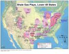
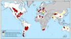
页岩气是富集在页岩地层内的天然气(Shale gas refers to natural gas that is trapped within shale formations)。页岩本生是很好的生油(气)岩之一。几十年来,利用水平井(horizontal drilling)和水利压裂(hydraulic fracturing )相结合开采出了之前无经济开采价值的页岩气。对页岩地层的天然气开采使得美国的天然气工业重新焕发活力。 图1 天然气资源地质概要图 图2 美国48个州页岩气储层分布图 参考资料: http://blog.sciencenet.cn/home.php?mod=spaceuid=339326do=blogid=430099 http://www.eia.doe.gov/energy_in_brief/about_shale_gas.cfm
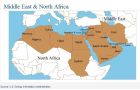
根据最新2009年统计数据表明,中东和北非国家天然气日产量占全球1/5。 In 2009 (the latest year data are available), Middle Eastern and North African (MENA) countries produced about 55 billion cubic feet per day (Bcf/d) of dry natural gas, which is about one-fifth of the estimated total worldwide daily supply and just under the average daily U.S. dry natural gas production of about 56 Bcf/d for the corresponding year. No single MENA country represented more than 5% of 2009 global dry natural gas production. Iran was the leading dry natural gas producer (12.7 Bcf/d) in MENA in 2009, a level about 20% of total 2009 U.S. natural gas consumption. MENA countries hold a much larger share of global liquefied natural gas (LNG) exports. In 2009, MENA accounted over 40% of worldwide LNG exports. Qatar's LNG exports alone reached nearly 1,800 billion cubic feet, about 20% of the global total.
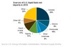
据美国能源署统计,中东和北非国家石油日产量占全球1/3。 Middle Eastern and North African (MENA) countries supplied about 30 million barrels per day (mmb/d) of liquid fuels in 2010, or more than one-third (see chart) of the estimated total worldwide daily supply of 86.3 mmb/d. Three countries: Saudi Arabia (10.07 mmb/d), Iran (4.25 mmb/d), and the United Arab Emirates (2.81 mmb/d), accounted for about 57 percent of total MENA liquid fuels production on average (see map) between January and November 2010 (latest figures available). Together, Algeria and Libya comprised about 5 percent of global liquid fuels production, or nearly 4 mmb/d.
根据美国地球物理学家学会(SEG)安排,韩国地球物理学家将来中国讲学。他在四月上中旬先后会在中国石油大学、中国地质大学、BGP和成都理工大学访问讲学。讲学内容围绕四维地球物理综合解释方面的最新进展,有兴趣朋友可以联系参加。 题目“ Incorporating the Fourth Dimension into Geophysical Data Interpretation” 内容简介 Most geophysical methods aim to obtain spatially varying information concerning subsurface material properties. As a result their measured data and interpreted results are expressed in terms of spatial coordinates. However, in some special geophysical approaches, in addition to the spatial domain, the variations of material properties in non-spatial dimensions are studied. Typical techniques of this kind are time-lapse geophysical monitoring and the Spectral Induced Polarization (SIP). These two different methods can be viewed under the same interpretation angle in the sense that nonspatial dimension (time or frequency) is incorporated into the data measurement and interpretation procedures. This lecture introduces a new interpretation approach in which both the spatial and nonspatial dimensions are jointly considered within the geophysical processing procedure. Common practice was to treat this type of "complex" geophysical data as an assembly of individual spatial datasets. Consequently, individual interpretation of each dataset leads to retrieving individual spatial parameter models which are difficult to correlate along the new axis. In the new approach, both measured data and the subsurface model are considered in a unified coordinate system defined in both spatial and nonspatial domains. Subsequently the sets of the individual structural models and data in the space domain become respectively a single model and a single data set in the new global coordinate system. This allows us to obtain a subsurface structure in both space and nonspace domains using just a single inversion process, and furthermore to introduce á priori information along the nonspatial axis. Overall the new approach provides a more solid tool to interpret this type of data and allows the more realistic representation of the subsurface structure. The lecture will be balanced between presentation of the theoretical development and the demonstration of the practical applicability. This will be achieved mostly by presenting practical application of the approach into resistivity monitoring and SIP data coming from various environmental and engineering case studies such as hydro-geophysical experiments, assessment of ground re-enforcement works, ground condition changes caused by tunnel construction works, landslide, etc. 中国访问和讲学时间安排 12 April Beijing,China China University of Petroleum (Beijing) Geophysical Society 13 April Beijing,China China University of Geosciences, Geophysical Society (Beijing) 14 April Beijing,China BGP 18 April Chengdu,China Chengdu University of Technology 韩国地球物理学家Jung-Ho Kim简介 Jung-Ho Kim received a B.Eng. (1980) in mining engineering, an M.Eng. (1982) and a Ph.D. (1987) in applied geophysics from Seoul National University, South Korea. In 1982 he joined the Korean Institute of Geoscience and Mineral Resources (KIGAM) where he is currently working as a tenured researcher. His research interests were mainly focused in the modeling and inversion of electrical and electromagnetic methods and their applications to engineering and environmental problems. His early research efforts in the 90's on resistivity inversion have contributed to rendering 2D- and 3D- resistivity imaging popular and the most common geophysical method in the Korean geophysical community in 90s. Further, Kim's research in radar methods involved addressing borehole and directional radar techniques. His research interests also extended into addressing geophysical problems in more complicated environments, such as water covered areas, anisotropic environments, etc. His recent research interests lie with multiparametric and multidomain interpretation of electrical and electromagnetic data. As a result of his research achievements, the Ministry of Science and Technology of Korea selected his research group, Geo-electric Imaging Lab., to become a National Research Laboratory. He served the Korean Society of Exploration Geophysicists (KSEG) as the editor-in-chief from 2005 to 2007 and as a special guest editor of the journal jointly published by KSEG, the Society of Exploration Geophysicists of Japan and the Australian Society of Exploration Geophysicists from 2004 to 2007. He has been awarded the distinction of "Researcher of the Year" from three institutions: the Korean Institute of Mineral and Energy Resources Engineering (1998), KIGAM (2007) and KSEG (2009). He is also an adjunct professor at the Korea Advanced Institute of Science and Technology, where he is teaching geophysical imaging techniques.
维基百科列出了一些著名的地震学家,可能不全,欢迎大家补充!我们会及时更新! Notable seismologists(引自维基百科网站) Aki, Keiiti Anderson, John G. Beroza, Gregory Bolt, Bruce Claerbout, Jon Dziewonski, Adam Marian Ewing, Maurice Galitzine, Boris Borisovich Gamburtsev, Grigory A. Gutenberg, Beno Hanks, Thomas, C. Hough, Susan Hutton, Kate Jeffreys, Harold Jones, Lucy Jordan, Thomas Kanamori, Hiroo Keilis-Borok, Vladimir Knopoff, Leon Lehmann, Inge Mallet, Robert Mercalli, Giuseppe Milne, John Mohorovičić, Andrija Oldham, Richard Dixon Sebastio de Melo, Marquis of Pombal Press, Frank Richards, Paul G. Richter, Charles Francis Sekiya, Seikei Sieh, Kerry Paul G. Silver Tucker, Brian Vidale, John Wen, Lianxing Winthrop, John Zhang Heng
 标签: 毛宁波