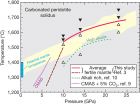
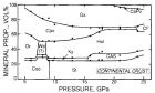
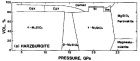
Plate Tectonics: Geological Aspects Prof. J. TARNEY MANTLE PETROLOGY IN RELATION TO PLATE TECTONICS Knowledge of mantle petrology and the constitution of the deeper mantle is important in trying to understand several aspects of plate tectonics. For instance, is there whole-mantle convection or two-layer convection? What are mantle plumes? What are superplumes? Does the subducting slab penetrate into the lower mantle? What happens to the slab at depth? Is the sub-continental mantle different from the oceanic mantle? First, some basic facts. Principal Internal Subdivisions of the Earth Region Depth (km) Mass (1025g) Mass Fraction Crust 0-Moho 2.4 0.004 Upper Mantle Moho-400 62 0.10 Transition Zone 400-1000 1000 0.17 Lower Mantle 1000-2900 245 0.41 Outer Core 2900-5154 177 0.30 Inner Core 5154-6371 12 0.02 Note that the crust makes up quite a small proportion of the total Earth. The main problems that have occupied geologists over the years are: What is the nature of the crust-mantle boundary (the MOHO). What is the nature of the low velocity zone? Is the lithosphere diferent in composition from the asthenosphere? What happens in the transition zone? What is the nature of the deep mantle? Fig. 1. The Earth in proportion. The thickness of crust is exaggerated. Note that the convecting upper mantle is quite shallow; but it is now known that at least some subducting slabs penetrate the 700 km discontinuity, and could well descend to the bottom of the lower mantle. When heated by the hot liquid core they could eventually rise as mantle plumes. The Continental Crust Though we know quite a lot about the upper crust, there is still quite a lot of uncertainty about the lower crust. Is there a real Conrad discontinuity separating the lower from the upper crust? Is the lower crust made up of dry granulite-facies rocks. Is it more mafic than the upper crust, perhaps as a result of intrusion of mafic magmas into the lower crust (called underplating). Or is it more mafic as a result of extraction of silicic granitic magmas from the deep crust? There a number of regions where we think tectonic activity has brought segments of the lower crust up for inspection. Notable examples are Kapuskasing and Pikwitonei in Canada (Precambrian crust), the Lewisian of NW Scotland (also Precambrian), Calabria in S. Italy and the Ivrea Zone in the Alps (both Phanerozoic). Fig. 2. Diagram (based on field and geophysical studies) to show how deep crust can be thrust up to high crustal levels. Kapuskasing structure, Ontario, Canada). The Lewisian of NW Scotland can be interpreted similarly, the high-grade lower crustal granulites being thrust over amphibolites 2.5 Gyr ago. Fig. 3. Estimates as to the extent to which we have sections thru two segments of Archaean crust and one segment of ‘recent’ Alpine crust. There is uncertainty as to whether actually we can directly sample the lowest crust. The Alpine sequence is in a series of thrust slices, but some rocks in region of the Ivrea zone have been down to greater depths and have re-bounded again to the surface. Perhaps the more important question is what causes high-P rocks to exhume? The Moho and the Lower Crust In the early 1960s there was considerable discussion between petrologists and geophysicists as to the nature of the MOHO . The P-wave velocity of most regions of the uppermost mantle beneath both continents and oceans lies in the range 8.2 ±0.2 km/sec. This in itself would restrict the composition of the mantle below the Moho to some combination of the following minerals (which have the appropriate properties): Olivine Pyroxenes Garnet (minor spinel, hornblende, phlogopite) The two principal rock types carrying these minerals are: PERIDOTITE (olivine + pyroxenes) and ECLOGITE (pyroxene + garnet), which are of ultramafic and mafic composition respectively. The nature of the lower crust is less certain. Exhumed Precambrian high-grade granulite-facies rocks (as in Figs. 2 3), which have equilibrated at depths of 25-30 km, have an intermediate (dioritic) bulk composition. But deep crustal xenoliths brought up in volcanic breccia pipes tend to be more mafic (gabbroic) in composition. So has the continental crust in part been underplated subsequently by mafic magma? Also, recent deep seismic investigations have revealed strong horizontal reflections in the deep (mainly post-Archaean) crust - what is the cause of these reflections? Do they represent mafic intercalations, differences in fluid content, crustal viscosity, or the bottoming out of shear zones (cf. Kusznir Matthews, 1988; Meissner Kusznir, 1987; Warner, 1990; Reston, 1990a). Comparison of crustal reflection profiles across the various tectonic zones of Europe (Wever et al., 1987; Sadowiak et al., 1991) has identified several different types of deep crustal structure: (a) abundant lamellae above the Moho as in BIRPS SWAT 4, (b) bands of reflectors as in BIRPS WINCH 3, (c) hyperbola-like diffractions as in BIRPS SWAT 6-9, (d) crocodile diverging reflectors observed in old collision zones, but not so far in the UK, (e) ramp and flat stuctures as in BIRPS SWAT 4 2/3, and (f) fishbone pattern observed across the Brabant massif. These features (cf. Meissner, 1989) are thought to represent different types of crustal structure. However it is felt that lower crustal viscosity (Meissner Kusznir, 1987) is a more important factor controlling development of reflectors than is composition, and the current view is that good lower crust reflectors might characterise mature crust, but that this pattern could be destroyed by either compression/collision (crocodiles, etc.), igneous intrusions or significant extension. Nonetheless it is commonly assumed that the lower crust is gabbroic in composition, either igneous (gabbro), or metamorphic amphibolite (wet) or granulite (dry). The MOHO as a phase transition Fig. 4 shows various suggestions (made at one time or other) for how the MOHO beneath oceans and continents could be a phase transition (change of mineralogy, but not a major change in composition). Serpentine is the hydrated variety of peridotite (with ca 12% water, thus lower density). Eclogite is the high-pressure form of basalt or gabbro. But are these models realistic? The serpentine-peridotite model is now discounted. The MOHO and the gabbro-eclogite transformation: Basalt transforms to eclogite at high pressures according to the equation: Olivine + pyroxene + plagioclase jadeitic pyroxene + garnet For this to be capable of explaining the MOHO it must be a relatively sharp transition, of no more than a few km. Green and Ringwood (1967) studied this experimentally to 30 kilobars (= ca 100 km) using a quartz tholeiite and an alkali basalt (Fig 5a, b). Fig. 5a. Experimental studies of Green Ringwood (1967) on quartz tholeiite basalt showed that transformation to eclogite occurred over a considerable depth interval. Note that eclogite has a lot more quartz than the equivalent basalt. But mantle eclogites have no quartz. Where does the silica go? With both compositions the transformation was found to be gradual. The disappearance of the low density phase (plagioclase) and its replacement by the high density phases (garnet and jadeite) occurred over a pressure range of ca 10 kb (= ca 25 km). Thus the MOHO cannot be a phase transformation and must be a compositional transition. The MOHO as a chemical transition Possible scenarios for the oceans and continents are shown in Fig. 6. In oceanic regions the form of the MOHO is known from dredging at fracture zones where peridotites (often serpentinised) have been recovered by dredging and drilling along with cumulate gabbros and pillow basalts. Actual sections of ocean floor are preserved in ophiolite complexes. The nature of the sub-continental MOHO is less certain, partly due to lack of knowledge of the lower crust. Composition of the Upper Mantle Our petrological knowledge of the upper mantle composition comes from several sources: (1) Nodules brought up in volcanic pipes ; (2) Large sections of mantle found in obducted ophiolites ; (3) Slices of mantle thrust up in mountain belts such as the Alps (Ivrea-Verbano Zone) and the Caledonides (especially Norway); and (4) Modelling backwards from erupted basalt compositions. (1) Olivine rich nodules are quite common in erupted alkali basalts worldwide, and are almost all of spinel lherzolite composition (olivine, orthopyroxene, Cr-diopside, spinel). In kimberlite (diamond) pipes there is a greater diversity in that both garnet peridotite and eclogite xenoliths occur (the former dominant). Some nodules contain diopside-rich, phlogopite-rich or amphibole-rich veins. It is thought that these nodules are representative of the sub- continental mantle. This material seems to be rather refractory (could not yield much basalt on melting), but at the same time can be quite enriched in incompatible trace elements such as Sr, Ba, K, Rb and the light rare- earths. (2) The peridotitic material in ophiolite complexes (obducted ocean floor) is mainly HARZBURGITE (ol+opyx) or DUNITE (ol), often cut by pyroxenite (opyx) veins and sometimes having chromite segregations (podiform chromites). There is a consensus that this mantle is the refractory residue left after basalt extraction at mid-ocean ridges. But are the pyroxenite veins the result of silica-rich fluids coming off the subduction zone? (see in Fig. 5a all the free quartz present in eclogite in subduction zones) - note that many ophiolites are thought to be fragments of back-arc spreading centres. (3) In the Ivrea Zone and the Lanzo-Seisia Zone of the Italian Alps, the peridotite slices are overlain by layered gabbros. They are mainly LHERZOLITE (ol-opyx-cpyx -spinel, or -hornblende or -phlogopite). Most carry veins composed of orthopyroxene, orthopyroxene-spinel, diopside-orthopyroxene, phlogopite-diopside, or hornblende. Different segments different veins, suggesting a complex make-up of the sub-continental mantle. Some of the rock types are similar to those brought up in volcanic breccia pipes. (4) Considerable progress has been made in understanding the compositions of basaltic rocks in recent years, and interpreting them in terms of melting models. So it is possible to model back to the primary mantle from which the basalt was derived, and estimate its composition. We now know that there are several distinct types of mantle, that have been kept separated for many hundreds of millions of years. They have distinct trace element and isotopic characteristics. (You may come across references to them as DMM, HIMU, EM1, EM2 and PREMA ), but there is uncertainty as to where they are located . Upper Mantle Mineralogy The variation in upper mantle mineral assemblages with temperature and pressure can be determined experimentally. But there is uncertainty about composition. Because a lot of observed mantle material is not primary, but has had a liquid (basalt) fraction removed by partial melting, Ringwood coined the term ' PYROLITE' for primitive fertile mantle - in effect dunite with basalt put back in! PYROLITE = 3 parts DUNITE + 1 part BASALT Mantle mineralogy varies mainly on account of the nature of the aluminous phase, which is P-T dependent, i.e. Olivine (MgFe) 2 SiO 4 + Orthopyroxene (MgFe) 2 Si 2 O 6 as major phases, plus: Plagioclase CaAl 2 Si 2 O 8 or Spinel (MgFe)Al 2 O 4 or Clinopyroxene (NaCa) 2 (AlSi) 2 O 6 or Garnet Mg 3 Al 2 Si 3 O 12 or Hornblende or Phlogopite Phase diagram (Fig. 7), though rather complicated, shows that plagioclase peridotite can exist only at very shallow depths where the geothermal gradient is high; spinel- and pyroxene peridotites have a larger stability field in the upper mantle; but garnet peridotite will occur at deeper levels (hence common as nodules in kimberlite pipes). Fig. 7. Summary of phase relations in pyrolite (after Green Ringwood) appropriate to upper mantle conditions. Wet solidus for small amount of hornblende breakdown. Note that only oceanic geotherm intersects this wet solidus. Methods for investigating deep mantle mineralogy Direct sampling of the deeper mantle is obviously impossible. Observed seismic velocity-depth functions however constrain the densities of likely mantle phases. Moreover, possible phase transformations in the transition zone of the mantle are very difficult to verify experimentally. For instance, in the 400-900 km depth region pressures are in the range 130-340 kilobars and temperatures 1500-3000°C ... beyond the range of most experimental equipment until recently. Now with diamond anvil apparatus, laser heating and on-line X-ray determinations it is possible to reach into this range, at least momentarily. Indirect methods have also proved reasonably successful. Fortunately high pressure phases tend to crystallise in structures which are already known (isomorphs). For instance we can compare silicates with germanates because germanates form a series of crystal structures closely parallel to those of silicates, but the transformations occur at lower pressures. Thermodynamics requires that the high pressure polymorph be denser, which limits possible structures. Once structure is known the bond lengths between cations and anions enable densities to be calculated. The Radius Ratio (Rcation/Ranion) determines type of crystal structure. At high pressures effective radii contract differentially, thus altering the radius ratio. Thus a new high pressure phase may appear when radius ratios exceed certain critical values. Large ions (e.g. Oxygen 1.40Å) contract more under pressure than small ions. Oxygen is more polarizable than smaller cations: Element Polarizability Radius (Å) O -- 3.1 × 10⁻²⁴cm 3 1.4 Si 4+ 0.04 × 10⁻²⁴cm 3 0.26 Mg 2+ 0.12 × 10⁻²⁴cm 3 0.72 Pressure thus increases covalent component of chemical bond. Phase transitions in the deeper mantle Refinement of seismic wave data has shown number of discontinuities (Fig. 8): These zones are: (1) LOW VELOCITY ZONE : from below lithosphere to about 200-250 km. Not always present. Asthenosphere has S-wave attenuation . . small amount of liquid, perhaps ca 1% melting? (2) MINOR DISCONTINUITY around 350 km. (3) MAJOR DISCONTINUITY at 400 km. (4) MAJOR DISCONTINUITY at 650 km. (5) Between 900 and 2700 km no major discontinuities, but some smaller ones. In general increase in seismic velocities and density explained by self-compression of homogenous material. The following explanations have been proposed to explain these discontinuities (Fig. 9): 350 km . Pyroxene forms a complex solid solution with pre-existing garnet in which one-quarter of silicon atoms are octahedrally co-ordinated, leading to 10% increase in density of pyroxene component: Mg 3 (MgSi)Si 3 O 12 Ca 3 (CaSi)Si 3 O 12 400 km . Olivine transforms to beta-Mg 2 SiO 4 which has SPINEL structure and is 8% denser than olivine. 500-550 km . Calcium silicate CaSiO 3 component of garnet transforms to extremely dense PEROVSKITE structure. Also beta-Mg 2 SiO 4 transforms to gamma-Mg 2 SiO 4 with 2% increase in density. 650 km . The spinel structure disproportionates to MgSiO 3 with PEROVSKITE structure and MgO with a ROCK SALT structure, i.e. Mg 2 SiO 4 MgSiO 3 + MgO. Additionally the MgSiO 3 .Al 2 O 3 component transforms to an ILMENITE structure and any sodium present will transform to a high pressure form of NaAlSiO 4 having CALCIUM FERRITE structure. Lower Mantle . Below 700 km no more major transformations are possible - the minerals are as close-packed as they can get. There is thus then a slow progressive increase in density to the mantle-core boundary. Fig. 9. Density changes with depth in the mantle, and the changes in mineral structure that have been proposed to explain them A point of interest is whether this sharp increase in density at 650-700 km acts as a barrier to mantle convection. If the slab cannot penetrate this boundary, does it pile up above 700km? Are there two convecting zones in the mantle: one above, one below the 700km discontinuity? Does this also coicide with a chemical boundary? Is there any chemical interchange across the boundary layer? Fate of the subducted slab: Ringwood 1991 Model One of the problems of plate tectonics is the fate of the subducting slab. This can be traced, from seismic evidence, to descend to about 650 km; but the evidence is somewhat conflicting regarding the extent to which it penetrates the dense 650 km discontinuity. (See references by Jordan and Hilst). Because the phase changes with depth are now known in some detail, both for ultramafic mantle material and for subducted basaltic ocean crust, it is possible to calculate their modal compositions with depth. For instance, the modal composition of pyrolite with depth is shown in Fig. 10: Fig. 11 shows the same calculations for basaltic ocean crust. Note that the plate which is subducting is not uniform mantle pyrolite but, because of melting at the ridge axis, it has segregated into a basaltic ocean crust (ca 5 km thick), residual harzburgite (from which the basalts were extracted) underlain by ordinary pyrolite. Knowing the mineral proportions and the densities of the minerals in each of the main rock types, undepleted pyrolite, depleted harzburgite, and basaltic ocean crust, it is then possible to calculate the density changes in each of these rock types with depth. The thermally equilibrated densities for these three rock types with depth are shown in Fig. 12 . Fig. 12. Densities (g/cc) of thermally equilibrated basaltic ocean crust, subducted harzburgite lithosphere compared with undepleted pyrolite mantle to depths of 800 km. Note that the ocean crust is mostly more dense and the harzburgite is less dense than pyrolite down to 650km depth, but then their positions are reversed. Fig. 13. Density differences between basalt - pyrolite and harzburgite - pyrolite as the subducted ocean crust sinks. The basaltic slab becomes less dense than mantle pyrolite in the depth range 650 - 750 km. The important point is that the subducted plate sinks because the basaltic component of the slab (now eclogite) is ca. 0.2 - 0.1 g/cc more dense than the enclosing host pyrolite to depths of 650 km, and exerts a strong 'slab-pull' force at subduction zones. The harzburgite part of the plate may also be slightly more dense initially because it is cold, but is inherently less dense once it has thermally equilibrated with the surrounding mantle pyrolite. However, because of the phase changes in pyrolite at the 670 km discontinuity, the basaltic crust suddenly becomes 0.2 g/cc less dense than the pyrolite in the depth range 650-750 km, whereas the harzburgite component of the slab becomes very slightly more dense. These effects are very clearly shown in Fig. 13. Ringwood (1991) argues that these changes then have the effect of trapping subducted basaltic ocean crust at the 670 km discontinuity, as shown in Fig. 14. Fig. 14. The effect of density differences is that basaltic ocean crust becomes trapped at the 670km discontinuity. Ringwood has suggested that the slab piles up at the base of the upper mantle, as shown in Fig. 14. By the end of the Archaean (2500 my ago) he envisages that the mantle structure around the 650km discontinuity would be as shown in Fig. 15. This layer is source for diamond-bearing kimberlite magmas according to Ringwood et al. (1992). Fig. 15. Likely mantle structure at the end of the Archaean as a result of subducted mafic ocean crust piling up at the 650 km discontinuity (after Ringwood). Fig. 17. Comparison between oceanic and continental lithosphere. Assuming constant spreading rates (present day) it can be calculated that, throughout Earth history, the amount of ocean crust which may have accumulated at the 650 km discontinuity would be at least 100 km thick. However because the harzburgite is inherently less dense and potentially more buoyant than the surrounding mantle, then when it heats up it may begin to ascend as blobs or diapirs, as shown in Fig. 16 (below). Fig. 16. Models of mantle differentiation involving storage of ocean crust at the 650 km discontinuity. This has interesting consequences as a mechanism to generate mantle plumes and 'hotspots'. Most plumes need to be generated at a discontinuity, either the 650 km one or at the core-mantle boundary. The mantle model (Fig. 16) shows that these plumes rise and penetrate the lithosphere to become the source of hotspot ocean islands. If these rising diapirs cannot penetrate the lithosphere, they may just add to the base of the lithsophere, and melts may penetrate it and metasomatise and chemically alter it. The ocean lithosphere is young (almost all less than 200 my) whereas the sub-continental lithosphere is older, cooler, thicker and more complex, as shown in both Figs. 16 17. Because of the different thermal regimes, and the influences of plumes, it is likely that there have been differences in the make-up of the lithosphere during Earth history. Fig. 18 (below) shows the likely structure of the modern mature Phanerozoic ocean lithosphere (left), which is regarded as being less depleted with increasing depth. Ocean plateaus (centre) have a very thick ocean crust, with (implicitly) a much more depleted harzburgitic mantle underlying it. In the Archaean (right) one suggestion is that the high mantle temperatures would have led to very high degrees of melting, to produce high-Mg komatiitic lavas, and leaving an extremely depleted pure-olivine dunitic residue. This oceanic structure is much more like that of modern oceanic plateaus, so was there plate tectonics in the Archaean or plateau tectonics (see later PlateLect-F)? Models of Mantle Differentiation This widely accepted model implies that mantle (or at least the upper mantle) is continually differentiating to form continental crust by a two-stage process. The crust formed is permanent and is not recycled back into the mantle. (1) Primitive pyrolite mantle rises at mid-ocean ridges, melts to form basaltic ocean crust overlying refractory harzburgite plate. (2) Plate sinks back into the mantle at subduction zones. Hydrated altered ocean crust dehydrates and causes melting of the basaltic ocean crust and of the overlying mantle wedge to yield andesitic magmas. (3) Andesitic magmas fractionate en route to the surface to produce more siliceous magmas. Hence sialic crust accretes laterally at continental margins, is of low density and is indestructible. Fig. 19. Simple box model of mantle evolution, showing how melting at spreading ridges produces ocean crust, which is then altered by hydrothermal activity and then subducted. Part of this subducted crust is then melted to form continental crust, and the residues then subducted to become part of the reservoir of the depleted (DMM) mantle. Small degree melts migrate upwards to enrich the sub-continental mantle and provide the source for alkali basalts. Sediment subduction may modify the sub-continental lithosphere. (after Tarney et al. 1980) A consequence of course is that if the continental crust has been extracted from the convecting mantle, the convecting mantle must have become progressively depleted in lithophile elements. This is now known as the ' DM ' mantle reservoir. This is the reservoir that supplies depleted mid-ocean ridge basalt ( MORB ). The real story is a little more complicated, as may be deduced form Fig. 19. Sediments may be subducted and contaminate the lithosphere under continental margins as well as the material stored at the 650 km discontinuity. Small degree melts permeate upwards and vein both the sub-continental and sub-oceanic lithosphere, but because the former is older, we generally observe more complex effects under the continents. Mantle Convection The diagrams below show some conceptual models of how the mantle may be convecting, and possible relationships between the upper and lower mantle (after Allègre et al.). There is still a very intense debate on whether the lower mantle is involved in manconvection. Fig. 20. Box models for crust-mantle evolution. On the left continental growth occurs through igneous contributions from both the upper and lower mantle. On the right the continental crust has mainly been extracted from the upper mantle, which is therefore depleted relative to lower mantle. Slab Penetration into Lower Mantle? Fig. 22. Cartoon showing how subducting slabs may either lay themselves out along the 650 km discontinuity (a), or penetrate the discontinuity to enter the lower mantle as in (b). The latter gives active back-arc spreading (see later lecture). The most recent analysis of the fate of the oceanic crust as it subducts into the mantle beneath the West Pacific island arcs (van der Hilst Seno, 1993), suggests that whereas that subducting beneath the Izo-Bonin arc and Shikoku Basin, south of Japan may be deflected and laid-out along the 650 km discontinuity in the transition zone (Fig. 22(a)), that further south beneath the Mariana Arc may penetrate into the lower mantle (Fig. 22(b)): UPDATES (1994/6) Ringwood's Megalith Model : The essence of the Ringwood megalith model is that while ocean lithosphere subduction is initially thermally driven because the downgoing slab is cold , the compositional buoyancy difference between the two becomes significant at 700km depth, resulting in the mechanical separation of basaltic from harzburgite/dunite components (see Fig. 15). However, recent modelling by Gaherty Hager (1994), using a range of viscosity contrasts for eclogite vs harzburgite, shows that the two are unlikely to separate. The slab buckles and folds as it reaches the 700 km discontinuity, but there is no obvious separation of eclogitic and harzburgitic components. The compositional buoyancy differences are subordinate to the overall thermal buoyancy. Nature of the Lower Mantle : While it is generally known that the convecting Upper Mantle (above the 670km discontinuity) is chemically depleted in lithophile elements because of the progressive growth and extraction of the continental crust from it, it has been commonly thought that the Lower Mantle is largely undepleted. However, Kerr et al. (1995) have proposed that the Lower Mantle is also depeleted, in part because of the return of subducting slab material right through the 670km discontinuity into the lower mantle: see also van der Hilst Seno (1993). This implies that there is much more interchange between Upper and Lower mantle than was first thought. The Lower Mantle feeds into the upper mantle in the form of large hot plumes (see later lecture). Figure 23 below shows how cool subducted material may go right into lower mantle, or get stuck termporarily at the 670km discontinuity and then 'drip' into the lower mantle: Fig. 23 (after Kerr et al. 1995) shows 2-layer convection of the mantle, as subducting plates lodge at the 670km discontinuity, or get convected back into the upper mantle; but with periodic interchange between the two as cold plates avalanche down into the lower mantle, and deep mantle plumes are displaced and rise to form major oceanic plateaus and continental large igneous provinces (LIPs). There may be composition differences between upper mantle and lower mantle as a result of such processes through Earth history. Larson and Kincaid (1996) then go on to argue that the breakup of major continents, as occurred with the Gondwana supercontinent in the Mesozoic (ca. 130Ma), leads to more rapid subduction of old cold ocean crust. These cold slabs then avalanche down and penetrate the 670km thermal boundary layer into the lower mantle. One effect is to raise the 670km TBL; another is to displace material from the deep lower mantle (D) which appears as major mantle plumes during the mid-Cretaceous magnetic superchron (120Ma - 80Ma). See later notes on mantle plumes. REFERENCES: Mantle Mineralogy (These references are probably more than you require at this stage, but as some aspects are followed up in more detail later in your courses, they may be useful to you.) ALLèGRE, C.J. 1982. Chemical geodynamics. Tectonophysics 81 , 109-132. ALLèGRE, C.J. TURCOTTE, D.L. 1986. Implications of a two-component marble-cake mantle. Nature 323 , 123-127. BLUNDELL, D.J. 1990. Seismic images of continental lithosphere. Journal of the Geological Society, London 147 , 895-913. GAHERTY, J.B. HAGER, B.H. 1994. Compositional vs. thermal buoyancy and the evolution of subducted lithosphere. Geophysics Research Letters 21 , 141-144. IRIFUNE, T. RINGWOOD, A.E. 1987. Phase transformations in a harzburgite composition to 26 GPa: implications for dynamical behaviour of the subducting slab. Earth and Planetary Science Letters 86, 365-376. IRIFUNE, T. RINGWOOD, A.E. 1993. Phase transformations in subducted ocean crust and buoyancy relationships at depths of 600-800 km in the mantle. Earth and Planetary Science Letters 117, 101-110. JORDAN, T.H. 1975. The continental tectosphere. Review of Geophysics and Space Physics 13, 1-12. JORDAN, T.H. 1978. Composition and development of the continental tectosphere. Nature 274, 544-548. JORDAN, T.H. 1981. Continents as a chemical boundary layer. Philosophical Transactions of the Royal Society, Lond . A301, 359-373. KEARY, P. VINE, F.J. 1991. Global Tectonics . Blackwell Scientific Publ., 302pp. KERR, A.C., SAUNDERS, A.D., TARNEY, J., BERRY, N.H HARDS, V.L. 1995. Depleted mantle-plume geochemical signatures: no paradox for plume theories. Geology 23, 843-846. KUSZNIR, N. and MATTHEWS, D.H. 1988. Deep seismic reflections and the deformational mechanics of the continental lithosphere. Journal of Petrology Special Lithosphere Issue , pp. 63-87. LARSON, R.L. KINCAID, C. 1996. Onset of mid-Cretaceous volcanism by elevation of the 670km thermal boundary layer. Geology 24, 551-554. MEISSNER, R. 1989. Rupture, creep, lamellae and crocodiles: happenings in the continental crust. Terra Nova 1, 17-28. MEISSNER, R. and KUSZNIR, N. 1987. Crustal viscosity and the reflectivity of the lower crust. Annales Geophysicae 5B, 365-373. MEISSNER, R., MATTHEWS, D.H. and WEVER, T. 1986. The Moho in and around Britain. Annales Geophysicae 4B, 659-666. MENZIES, M.A. 1990. Archaean, Proterozoic, and Phanerozoic lithospheres. In: M.A. Menzies (Editor ) Continental Mantle , Clarendon Press, Oxford, pp.67-86. RINGWOOD, A.E. 1974. The petrological evolution of island arc systems. Journal of the Geological Society, London 130, 183-204. RINGWOOD, A.E. 1975. Composition and Petrology of the Earth's Mantle . McGraw-Hill, New York. RINGWOOD. A.E. 1982. Phase transformations and differentiation in subducted lithosphere: implications for mantle dynamics, basalt petrogenesis, and crustal evolution. Journal of Geology 90, 611-643. RINGWOOD, A.E. 1985. Mantle dynamics and basalt petrogenesis. Tectonophysics 112, 17-34. RINGWOOD, A.E. 1986. Dynamics of subducted lithosphere and implications for basalt petrogenesis. Terra Cognita 6, 67-77. RINGWOOD, A.E. 1991. Phase transitions and their bearing on the constitution and dynamics of the mantle. Geochimica et Cosmochimica Acta 55, 2083-2110. RINGWOOD, A.E. IRIFUNE, T. 1988. Nature of the 650-km seismic discontinuity: implications for mantle dynamics and differentiation. Nature 331, 131- 136. RINGWOOD, A.E., KESSON, S.E., HIBBERSON, W. WARE, N. 1992. Origin of kimberlite and related magmas. Earth and Planetary Science Letters 113, 521-538. SADOWIAK, P., WEVER, T. and MEISSNER, R. 1991. Deep seismic reflectivity patterns in specific tectonic units of Western and Central Europe. Geophysics Journal International 105, 45-54. TARNEY, J., WOOD, D.A., SAUNDERS, A.D., CANN, J.R. VARET, J. 1980. Nature of mantle heterogeneity in the North Atlantic: evidence from deep sea drilling. Phil. Trans. Roy. Soc. London A297, 179-202. van der HILST, R. SENO, T. 1993. Effects of relative plate motion on the deep structure and penetration depth of slabs below the Izu-Bonin and Mariana island arcs. Earth and Planetary Science Letters 120, 395-407. WEVER, T., TRAPPE, H. and MEISSNER, R. 1987. Possible relations between crustal reflectivity, crustal age, heat flow and viscosity of the continents. Annales Geophysicae 5B, 255-266. WARNER, M.R. 1990. Basalts, water or shear zones in the lower continental crust? Tectonophysics 173, 163-173. WYLLIE, P.J. 1971. The Dynamic Earth . Wiley, London APPENDIX Germanates as high pressure models of silicates Trying to elucidate the petrological nature of the deep mantle is not easy because it is difficult to re-create such high-pressure - high-temperature conditions in the laboratory. At least for any length of time: Laser heating and momentary shock treatment can do it for a short time, but as silicate reactions usually take a long time to reach equilibrium condition, this leads to huge uncertainties in P-T parameters. However, in the early years, mineral chemistry principles were used to predict high pressure behaviour. Use of germanates to model high pressure silicates was first suggested by Goldschmidt in 1931. Si and Ge are tetravalent and in same group in the Periodic Table. RADII: Si 4+ 0.26A Ge 4+ 0.40A Silicates and germanates usually isostructural and there is a wide range of germanate structures. So, if it is possible to synthesize a germanate structure at moderate pressures it is likely that an equivalent silicate structure will exist at higher pressures. If a germanate displays a phase transformation at a given pressure, the corresponding silicate often displays the same transformation but at a much higher pressure. This is because the critical radius ratio R Ge /R Oxygen for transformation to a new phase is attained at much lower pressures with Ge. Some germanates (e.g. GeO 2 ) can crystallise at zero pressure while the equivalent silicate needs 100 kb pressure. Many transformations in germanates involve change from 4- to 6-fold co-ordination with oxygen. Compare: NaAlSi 2 O 8 NaAlSi 2 O 6 + SiO 2 28kb (silicate) Albite Jadeiite + Rutile str NaAlGe 2 O 8 NaAlGe 2 O 6 + GeO 2 5kb (germanate) 2CoSiO 3 2Co 2 SiO 4 + SiO 2 100kb (silicate) Pyroxene Spinel + Rutile str 2CoGeO 3 2Co 2 GeO 4 + GeO 2 10kb (germanate) These lines of reasoning allowed predictions to be made as to what types of structure might exist at depth in the Earth. That's All Folks! PLATE TECTONICS: Lecture 2 OCEAN RIDGE MAGMATISM Magma production at the Earth's mid-ocean ridge system far exceeds that in any other tectonic environment, and this has been so since the early Precambrian. It is the dominant way in which internal heat is dissipated. The structure of a mid-ocean ridge is shown below: Note how the lithosphere thickens as it moves away from the ridge. Because the Earth's magnetic field oscillates between north and south at intervals of a few hundred thousand (or the odd million) years the basalts erupted then take on the current magnetisation, and so give rise to the seafloor magnetic lineations (patterns shown above) that can be used to date the ocean floor. Melting of pyrolite mantle extracts basaltic liquids to form the ocean crust, leaving a residue of harzburgite (ol+opyx) forming the underlying lithosphere. The ocean lithosphere suffers extensive hydrothermal alteration at the ridge (see below), but the rocks eventually finish up subducting back into the mantle: It is because these fluids are released in the Benioff Zone as the slab is subducted that magmas are able to be generated in the mantle wedge above the subduction zone. It is fluid, not friction, which is responsible for active margin magmatism. But it is ridge processes which make it all possible. So we need to look at these. Why does melting occur? Melting temperatures of most silicate minerals increase with increasing pressures. So temperatures of solid mantle material at depth may be higher than the melting point of mantle near the earth's surface. As hot deep mantle rises beneath spreading ridges it will, as pressure falls, rise above its solidus, and begin melting. The simplified situation is as follows: As the uprising mantle crosses the geotherm it begins to melt, and as the solidus temperature of mantle falls with decreasing pressure, the temperature of the melt increases relative to this solidus, thus effectively giving higher degress of melting with decompression, as shown. The amount of melt generated will be limited by the latent heat of fusion (which is high for silicates), and as the melting range of mantle peridotite lies between ca. 1100°C and ca. 1700°C, it is likely that most ridge basalts are partial (rather than complete) melts of mantle. The magma may enter a chamber in the ocean crust and begin crystallising, giving the following P-T path: There is the possibility of superheat (i.e. temperature above the liquidus) if the magma can rise quickly, but it is apparent that most magmas are erupted or emplaced without superheat (a possible exception are ultramafic lavas called komatiites ). Because we haven't yet been able to drill very far down into oceanic crust, the only way we can begin to understand what happens to the basaltic magma as it rises up at the ridge is to look at ophiolite complexes. There are many of these in the Alpine belt, although we are not always sure that these mafic slivers represent true ocean basin crust or whether some (or all) may represent marginal basin crust or the roots of island arcs. Nonetheless, by putting together information from a number of ophiolite complexes, particularly Troodos on Cyprus, we come up with the following idealised section: Not every ophiolite has all these components complete, and it is not always for tectonic reasons. Often the gabbro is missing, or the sheeted dykes, and in some cases the dykes may intrude the harzburgite. Of course sheeted dykes can only be formed if there is a continuously extending magma chamber (try doing it without!). So if sheeted dykes are missing it may mean that there has not been such a magma chamber. In fact there is a lot of debate on this issue. Some geophysical studies indicate a possible continuous magma chamber beneath the East Pacific Rise. However, the EPR is a smooth fast-spreading ridge, and maybe there is enough thermal input to keep a continuous magma chamber going. On the other hand in the slow-spreading Atlantic with its central rift valley and irregular topography, there is no direct evidence for a continuous magma chamber. Some workers, including those at Leicester, suggest that with slow-spreading ridges, each eruption may be a distinct event, and that any magma chamber is only short-lived. Some sections of the Atlantic ridge, like the FAMOUS area (south of the Azores) have numerous small volcanic cones, and this is now being recognised all over the Atlantic. A consequence is that that there may be a variety of magma chamber profiles, with those from fast-spreading ridges having fat onion shapes, those from rather slower-spreading ridges having leek shapes. Very slow spreading ridges (e.g. SW Indian Ridge) may just have dykes feeding lavas which directly overly peridotite. There are ophiolites with this profile, where the dykes cut harzburgite tectonite and gabbro is only locally developed. Even with the type Troodos ophiolite, which has a moderatley thick gabbro section, geochemical studies have shown that the gabbros are in fact a compound of a number of small bodies. Transform Fault Effects It has long been known that the ocean crust is much thinner in the vicinity of oceanic transform faults. Also that a greater variety of rock types can be drilled or dredged in the vicinity of transforms, and that there is usually a significant topographic difference between the two sides of a transform fault (esp. the larger ones). The latter effect arises because the ocean crust sinks as much as 3 km over the first 50 m.y. of its existence. So the greater the age difference of adjacent bits of ocean crust across a transform, then the greater the height of the transform wall. Obviously if the wall is 1 km high, then a large amount of rubble will fall down onto the lower plate, and deeper parts will become exposed. Moreover as the transform fault moves, the movement can deform the basalts into hornblende schists. The thinner crust arises from the cold-wall effect, i.e. that the mantle rising up adjacent to the transform fault are actually in contact with older, and therefore cooler, oceanic crust on the other side. Cooler conditions give less melt and therefore thinner crust. Thinner crust also means there is more likelihood of mantle being exposed in the transform wall, again increasing the variety of rock types. METAMORPHISM OF OCEANIC CRUST There has been a very great deal of interest worldwide in the metamorphism and hydrothermal alteration of oceanic crust. After all there are few geological situations where you have a large red-hot magma chamber below and a 3 km column of ocean water on top trying to dowse it. There are a number of important questions that could be asked: (a) how extensive is the metamorphism, and how far distant from the ridge do the metamorphic effects extend? (b) if there is extensive hydrothermal activity, does this lead to equally extensive mineral deposits which could be mined? (c) would the metamorphism affect the magnetic anomaly patterns that are so useful for dating ocean crust? (d) is the ocean crust so hydrated that this represents an important source of fluids at subduction zones? (e) does the hydrothermal interchange influence the chemical budget of the oceans? There is no doubt that ophiolite complexes (obducted bits of ocean crust in mountain belts) are usually 90% altered, and there was debate during the 60's and 70's whether this was a result of metamorphism in the mountain belt during orogensis, or resulted from ocean floor metamorphism. The latter is now the favoured explanation. Many of the samples of ocean crust recovered from the ocean floor by drillling or dredging are altered. Metamorphism Cann (1979) recognises 5 different mineral assemblage facies in oceanic basalts recovered by dredging, drilling etc. The rocks characteristically preserve igneous textures. (1) Brownstone Facies Low temperature ocean floor weathering or cool hydrothermal alteration. Products usually have yellowish brown tint due to oxidising conditions (bluish grey if reducing). Mineral assemblages not in equilibrium; just replace specific primary phases. Olivine replaced by Celadonite (K-rich dioctahedral Fe-illite) under more extreme alteration. This fills vesicles and replaces glass. Under reducing conditions this is a Saponite (Mg-rich trioctahedral smectite). Pyrite common. Thus basalt has clay alteraton products. Plagioclase remains fresh, though under extreme alteration may be partly replaced by K-feldspar (Adularia). Glass: Where basalt glass is common, Palagonite (orange coloured disordered illite) occurs, often associated with a low temperature zeolite (Phillipsite) and Calcite. Fig. 8. Diagram from Cann (1979) tries to indicate how the minerals in a basalt affected by hydrothermal activity contribute to the secondary phases. At low temperatures it is mainly the basalt glass and olivine which are unstable and contribute to brownstone facies minerals, but plagioclase and then augite and iron oxide become progressively involved at higher grades until the whole rock recrystallises. (2) Zeolite facies ( Temperature above 50-100°C.) Here Phillipsite is replaced by higher temperature zeolites - Analcite and Natrolite. Distinct zones of zeolites occur on Iceland. Mafic minerals replaced by Saponite or Saponite-Chlorite mixed layer minerals, coarser grained than in Brownstone Facies. Plagioclase may also be partly replaced by saponite, but augite stays fresh. Upper limit of facies (250-300°C) marked by disappearance of zeolites and saponite and incoming of albite and chlorite. (3) Greenschist Facies Albite ± chlorite ± actinolite ± epidote ± sphene. Degree of alteration variable, primary assemblages may be completely replaced. Augite is commonly a relic, veins are common, often quartz-bearing. Assemblages may or may not be equilibrium ones. Upper limit of facies marked by disappearance of albite, chlorite and actinolite and the appearance of green aluminous hornblende associated with more calcic plagioclase (An 20-30 ). (4) Amphibolite Facies Hornblende+Ca-plagioclase + titanomagnetite±epidote. This assemblage is most commonly developed in coarser grained rocks - dykes and gabbros - obviously of deeper origin. Degree of metamorphism variable. Some primary hornblende occurs in gabbros or diorites, but it is clear that amphibolite facies metamorphic assemblages are superimposed on this. So metamorphism closely follows magmatic activity. The results can be summarised in the following table. Note that it is not just the mafic ocean crust (basalt or dolerite) that is altered. The mantle itself is often brought up along faults, transforms and fracture zones, and this is frequently altered to serpentine (ca. 13% water) at temperatures below 450°C. But other hydrous minerals such as talc, tremolite and chlorite are possible at higher temperatures. There are also 3 different varieties of serpentine: antigorite, chrysotile (the glossy variety) and lizardite. ________________________________________________________________________________ Summary of Mineral Assemblages in Altered Crust Facies BASALT PERIDOTITE Brownstone Celadonite + Phillipsite + Palagonite + Saponite ? Zeolite Saponite + mixed layers + analcite + natrolite ? Greenschist Chlorite + Albite + Actinolite + Epidote + sphene Lizardite Chrysotile Magnetite Amphibolite Hornblende + Plagioclase + Iron Oxide Tremolite + Olivine + Enstatite Gabbro Augite + Plagioclase + Hypersthene + Iron Oxide + Olivine Enstatite + Diopside Chromite ____________________________________________________________________________ General Comments : Greenschist and amphibolite facies metamorphism of the ocean floor differs from these facies in normal regional metamorphism in that: (a) The thermal gradient is very high: can be several-100°C per km compared with 30 - 50°C/km in regional metamorphism. (b) No garnet is developed in mafic rocks (pressures are not high enough). (c) The rocks lack deformation textures (except in samples recovered from transform fracture zones) (d) Very variable degree of recrystallization, because lower grade metamorphic assemblages are superimposed on earlier higher grade ones. This is because hydrothermal activity continues under cooler conditions as crust progressively moves away from ridge. (In regional metamorphism it is more common for the rocks to equilibrate at one set of P-T conditions) Despite ca. 20 years of drilling, the deepest drill holes in the ocean floor (several hundred metres) have still only penetrated brownstone- and zeolite-facies rocks. No greenschist facies or amphibolite facies rocks penetrated. To see what happens deeper down, we really need to examine ophiolite complexes. Ocean floor metamorphism - Sarmiento Ophiolite, Chile The Sarmiento ophiolite (Saunders et al. 1979) is one of a series of discontinuous mafic lenses that represent the mafic floor of an extensional back-arc basin that was closed and uplifted in mid-Cretaceous times in the southern Patagonian Andes. Excellent vertical exposures have enabled the distribution of metamorphic zones resulting from the hydrothermal metamorphism to be established (Stern Elthon, 1982?). Lithological sequence at Sarmiento consists of: 2 km pillow lavas 300 m sheeted dykes 1 km gabbros with plagiogranite Four main metamorphic equilibrium mineral facies can be recognised: (1) Zeolite Facies . Zeolites, palagonitized glass ± smectites ± calcite ± quartz ± pyrite ± sphene ± albite. (2) Greenschist facies . Chlorite, epidote, Na-plagioclase, sphene, ± quartz ± calcite ± biotite ± pyrite. (3) Lower Actinolite Facies . Low-Al (2-5% Al 2 O 3 ) fibrous green amphiboles, Ca-plagioclase, sphene ± biotite ± calcite. (4) Upper Actinolite Facies . Higher-Al (5-8% Al 2 O 3 ) brown-green amphiboles, Ca-plag. (An50), titanomagnetite, ± ilmenite ± biotite. These are arranged vertically in the complex, with metamorphic grade increasing downwards. However, intensity of metamorphism also varies and is at a maximum within the sheeted dyke unit. Moreover, the lower temperature facies may be superimposed on the higher grade ones. The histograms show the intensity of metamorphism in each of the components of the complex for each of the four metamorphic grades. Significant Points : (1) The intensity of metamorphism (recrystallisation) is greatest in the sheeted dykes. This is because the vertical dyke margins permit easy access of circulating fluids, coupled with the fact that higher temperatures speed reaction rates. The high water-rock ratios in the sheeted dyke zone mean that the rocks are strongly leached. Any chemical elements not required by the newly forming minerals (hornblendes and chlorite) are removed upwards by the fluids. This means elements like Rb, U, Th, K, some Sr, Ba and chalcophile elements like Zn, Cu and Pb are removed from the deep dyke rocks. Some of the former group will be re-absorbed by the zeolites and clays in the uppermost 'Brownstone' part of the section, others are dissolved in seawater, whereas the chalcophile elements form valuable mounds of sulphide on the seafloor (black smokers). Overall, the hydrothermal activity achieves a major amount of vertical chemical redistribution within the ocean crust. The mobile elements are moved to the top of the ocean crust. These are the same elements that become mobile when the ocean crust is subducted and arc magmas are generated. (2) As thermal gradients fall (i.e. crust moves away from ridge axis) circulating water permits lower grade assemblages to form - superimposed on high grade ones. But this secondary metamorphism is of lower intensity because circulation channels become blocked with the growth of secondary minerals. The sedimentary cap that progressively builds up on top of the basalts will eventually block circulation. There is a good example of this in the Megaleg Chemical fluxes in oceanic crust - the 'MEGALEG' The Deep Sea Drilling Project Legs 51-53 drilled two deep 200 m holes in Cretaceous (110 m.y.) oceanic crust in the western Atlantic near Bermuda. The holes were only 450m apart, but one hole, Hole 417A, drilled some of the most altered basalts found on the ocean floor, whereas those in Hole 417D were relatively fresh. All alteration was at 'Brownstone' facies. Basalts in both holes petrographically similar. The differences just reflect the relative access by circulating fluids. Compare compositions (water free): 417A hyaloclastite 417A avge 417D avge SiO 2 53.6 49.9 49.4 TiO 2 1.13 1.50 1.50 Al 2 O 3 11.4 10.9 10.5 MgO 5.80 5.44 6.14 CaO 3.68 10.3 13.5 Na 2 O 1.70 2.21 2.40 K 2 O 4.36 1.79 0.12 Note significantly higher K 2 O and lower CaO in altered rocks, particularly the most fragmentary hyaloclastite 417A, which is the most permeable of rock types. Interpretation : Hole 417A is on basement 'high' which remained uncovered by sediment for a considerable time thus permitting long-term circulation of warm (30°C) water. Hole 417D was a located in a topographic depression which became quickly filled with sediment which blocked extensive water circulation. The results were first interpreted to suggest that the ocean crust may be a tremendous 'sink' for K 2 O and Rb transferred from sea water through hydrothermal circulation involving major volumes of seawater. However, how much of the Rb, K 2 O, etc. is derived through leaching from more altered rocks (e.g. in sheeted dyke unit) at deeper levels? To see what other chemical changes occur during alteration of oceanic crust it is best to look at the type ophiolite, the Troodos Complex on Cyprus. This has been intensively studied through field investigations, mining operations and by scientific drilling. Troodos formed at 91 Ma, but hydrothermal activity continued for a further 40 Ma after crust formation (Gallahan Duncan 1994). Chemical Changes in Oceanic Crust - Troodos Ophiolite 1. Strontium Isotopic Composition Studies by Spooner et al. (1977) of zeolite- to amphibolite-facies altered basalts on Cyprus show that 87Sr/86Sr ratios are increased relative to fresh basalts and gabbros. 87 Sr/ 86 Sr Zeolite 0.80760 ± 3 Altered Basalt 0.7069 Fresh Gabbros 0.70338 ± 10 Cretaceous Seawater 0.7076 Similar results have been obtained on altered ocean basalts. High 87 Sr/ 86 Sr in altered mineral products can be leached away in dilute acid so that unaltered minerals yield the original magmatic Sr isotopic ratios. Spooner suggested that interchange of seawater Sr with ocean crust Sr occurs during hydrothermal circulation and may buffer Sr isotope composition of seawater: 87 Sr/ 86 Sr Fresh Ocean Crust Av. 0.703 Seawater Average 0.709 Continental Rocks 0.712 There is a considerable variation in 87Sr/86Sr in seawater with time that can be linked to varying plate activity. This is discussed in more detail below. 2. Oxygen and Hydrogen Isotopic Compositions Spooner et al. (1977) showed that oxygen isotope ratio values in Troodos and other Mediterranean ophiolites were higher ( d18O = ca. 9) than in fresh 'mantle-derived' basalts (d18O = 6) and were consistent with alteration by seawater at high temperatures of ca. 350°C. The interesting point about this is that because oxygen is the most abundant element in any rock, it is necessary to exchange almost all the oxygen in the rock to significantly change the isotopic ratio. In other words, water-rock ratios are high, or large volumes of seawater interact with ocean crust at spreading centres. The implication is that if oxygen can be exchanged on this scale then many other elements can be changed too. Heaton and Sheppard (1977) showed that the isotopic composition of hydrogen in water in equilibrium with chlorite and amphibole from altered dykes from Cyprus was indistinguishable from that of seawater. Comment : Altered oceanic crust (now with higher 87Sr, 18O and 2H contents) which is subducted at Benioff Zones may modify the isotopic composition of island arc magmas from normal mantle values. The hydrous fluids driven off as the subducting slab heats up as it goes down subduction zones will be enriched in the heavy isotope of these elements. So it is not surprising that island arc magmas differ in their isotopic ratios from other mantle-derived igneous rocks. Sulphide Ore Deposits in Oceanic Crust Sulphide deposits have been found on East Pacific Rise. They occur at positions of discharge of hydrothermal systems (black smokers). On Cyprus ore bodies are 500 m x 350 m x 50 m, and consist of pyrite and chalcopyrite with accessory marcasite, sphalerite and galena. Chemical and isotopic data suggest that the sulphide deposits mostly formed on seafloor: (a) Fluid inclusions in ore material have composition of seawater. (b) Ore material has 87 Sr/ 86 Sr = 0.7075. (c) Hydrogen isotope composition same as seawater. Calculations suggest ore bodies may have formed in 100,000 yrs. Fluid inclusion studies suggest that the temperature of the plume of rising hydrothermal fluid was 300 - 350°C. Spooner suggests that contained sulphur has isotopic composition of seawater sulphate. So ocean crust ore sulphide may be largely of reduced seawater sulphate origin. The following diagrams illustrate some of the processes of convective seawater circulation and the respective mineral zones in the formation of hydrothermal mounds on the ocean floor (l.h. side) and other submarine envirnments (r.h. side of 1 st picture): These diagrams illustrate the importance of fault-control on the location of the discharge zones of hydrothermal activity, of permeability in allowing the hydrothermal solutions to circulate, of P-T-pH-Eh in controlling which minerals are stable and thus which elements are leached and which are deposited. Comment: Large amounts of sulphide in adddition to chloride and hydroxyl are added to ocean crust as a result of hydrothermal activity. A lot of pre-concentration of potential ore metals already occurs in the ocean crust. So what happens when ocean crust goes down subduction zones? At subduction zones chlorine- and sulphide-rich fluids are released during dehydration. Could this give us a possible explanation for porphyry copper deposits that occur commonly at continental margins like the Andes? Spooner has stressed that water is needed as transport medium, chloride for metal complexing and sulphur for fixing the metals as solid phases. All these are present in ocean crust as it is subducted. Metal Deposits on Ocean Floor Sulphide ores common in ophiolites. Could we locate them on ocean floor? Many hydrothermal discharge zones have now been found at ocean ridges (mostly in the East Pacific, but also now in the Atlantic) by submersible investigations. These are potentially important ore reserves in terms of total volume, but individual deposits are too small to mine economically, even by remote techniques. Discharge areas may be located by trace element profiles in seawater near the ocean bottom. So we can find them, but to exploit them is another matter. REFERENCES: Oceanic Crust CANN, J.R. 1974. A model for ocean crust structure developed . Geophysical Journal of the Royal Astronomical Society 39 , 169-187. CANN, J.R. 1979. Metamorphism in the ocean crust. In: TALWANI, M. et al. (eds ) Deep Drilling Results in the Atlantic Ocean: Ocean Crust . Maurice Ewing Series 2 , 230-238. American Geophysical Union CARLSON, R.L. JOHNSON, H.P. 1994. On modelling the thermal evolution of the oceanic upper mantle: An assessment of the cooling plate model. Journal of Geophysical Research 99 , 3201-3214. ELTHON, D. STERN, C.R. 1978. Metamorphic petrology of the Sarmiento ophiolite complex, Chile. Geology 6 , 464-468. FLOWER, M.J. 1991. Magmatic processes in oceanic ridge and intraplate settings. In: FLOYD, P.A. (ed ) Oceanic Basalts . Blackie, Glasgow, pp.116-147. GALLAHAN, W.E. DUNCAN, R.A. 1994. Spatial and temporal variability on crystallisation of celladonites within the Troodos ophiolite, Cyprus: Implications for low-temperature alteration of the oceanic crust . Journal of Geophysical Research 99 , 3147-3161. LIN, J. PARMENTIER, E.M. 1989. Mechanisms of lithosphere extension at mid-ocean ridges . Geophysical Journal International 96 , 1-22. MARSH, B.D. 1989. Magma chambers. Annual Reviews of Earth and Planetary Sciences 17 , 439-474. NICOLAS, A. 1989. Structures of ophiolites and dynamics of ocean lithosphere . Kluwer, Amsterdam, 367pp. NICOLAS, A., FREYDIER, Cl., GODARD, M. VAUCHEZ, A. 1993. Magma chambers at oceanic ridges: How large? Geology 21 , 53-56. RONA, P.A. 1985. Hydrothermal mineralization at slow spreading centers: Red Sea, Atlantic Ocean and Indian Ocean. Marine Mining 5 , 117-145. RONA, P.A. 1986. Mineral deposits from sea-floor hot springs. Scientific American XX, 66-74. SAWKINS, F.J. 1976. Metal deposits related to intracontinental hotspot and rifting environments. Journal of Geology 84 , 427-430. SAUNDERS, A.D. TARNEY, J. 1984. Geochemical characteristics of basaltic volcanism within back-arc basins. In KOKELAAR, B.P. HOWELLS, M.F. (eds) Marginal Basin Geology . Special Publication of the Geological Society, London 16 , pp.59-76. SAUNDERS, A.D. TARNEY, J. 1991. Back-arc basins. In: FLOYD, P.A. (ed) Oceanic Basalts . Blackie, Glasgow, pp.219-263. SAUNDERS, A.D., TARNEY, J., STERN, C.R. DALZIEL, I.W.D. 1979. Geochemistry of Mesozoic marginal basin floor igneous rocks from southern Chile. Geological Society of America Bulletin 90 , 237-258. SINTON, J.M. DETRICK, R.S. 1992. Mid-ocean ridge magma chambers. Journal of Geophysical Research 97 , 197-216. SPOONER, E.T.C., CHAPMAN, H.J. SMEWING, J.D. 1977. Strontium isotopic contamination and oxidation during ocean floor hydrothermal metamorphism of the ophiolitic rocks of the Troodos Complex, Cyprus. Geochimica et Cosmochimica Acta 41 , 873-890. THOMPSON, G. 1991. Metamorphic and hydrothermal processes: basalt - seawater interactions. In: FLOYD, P.A. (ed) Oceanic Basalts . Blackie, Glasgow, pp.148-173. WHITE, R.S. 1991. Structure of ocean crust from geophysical measurements. In: FLOYD, P.A. (ed) Oceanic Basalts . Blackie, Glasgow, pp.30-48. VARIATION IN Sr ISOTOPIC COMPOSITION of SEAWATER WITH TIME: the plate tectonics connexion You may wonder what the strontium isotopic composition of seawater has to do with plate tectonics? Surprisingly the variation in the Sr isotopic composition of ocean seawater with time it is turning out to be an excellent monitor of past plate tectonic activity. But we are only just beginning to understand why. For instance the present day seawater Sr isotopic composition (expressed as 87 Sr/ 86 Sr) is 0.709, and because ocean water is globally well mixed, all modern shells and limestones that incorporate seawater Sr have this ratio. By measuring the Sr isotopic ratios in limestones or shells from older geological formations it is possible to log the Sr isotopic variations in seawater with time. The early work by Peterman et al. (1970) and others produced the following curve: It can be seen that there is a progressive increase from the late Jurassic to the present day. However there is also a decrease from the early Carboniferous to the late Jurassic. So there must be some geological process or processes which produce a decrease in 87 Sr/ 86 Sr as well as those which produce an increase. So what are these processes? Rubidium-87 ( 87 Rb) is radioactive and decays to 87 Sr , so that the ratio 87 Sr/ 86 Sr must increase in the Earth with time ( 86 Sr is unradiogenic so stays constant). However the rate at which the 87 Sr/ 86 Sr ratio will increase depends on the elemental Rb/Sr ratio of the rock. The Earth's mantle is low in Rb relative to Sr, so mantle derived rocks, which have a very low Rb/Sr ratio, tend to have low 87 Sr/ 86 Sr (the ratio has increased from only 0.699 to 0.703 over the last 4500 m.y.!). However, crustal rocks such as granites and shales are rich in Rb and have a high Rb/Sr ratio so, given time, become enriched in 87 Sr and have a high 87 Sr/ 86 Sr. So if seawater interchanges chemically with crustal rocks its ratio of 87 Sr/ 86 Sr will increase, wheareas if it interchanges with mantle rocks this ratio will be pulled down again. Clearly to change the ratios in a reservoir the size of an ocean must indicate (at least) two very big process, one pushing the ratio up and the other dragging it down. What are they? Significance of Increasing Sr Isotope Ratios Clearly, enhanced erosion of high 87 Sr/ 86 Sr continental material will drive the ratio up. As feldspars and micas weather and breakdown to clays their radiogenic Sr is released. This is very soluble in river water and finishes up in the sea. But enhancement can only come if the proportion of mountain belts is increased. And this will be brought about by continental collision at the end of the Wilson Cycle. So does the sharply increasing curve since the late Jurassic then monitor the development of our recent mountain belts such as the Alps, Himalayas and Andes? There have been a number of attempts to model this most recent 100 m.y. growth, since the seawater variation curve for this period is very well known (after Richter et al . 1992): The Sr flux into the oceans can be estimated from the large rivers, e.g., River Sr Flux (mol/yr) 87 Sr/ 86 Sr Amazon 2.2 × 10⁹ 0.7109 Orinoco 0.2 × 10⁹ 0.7183 Himalayan-Rivers total 7.7 × 10⁹ 0.7127 Global Total 3.3 × 10¹⁰ 0.711 The growth is most rapid between 40 m.y. to the present, and particularly in the period 20 - 15 m.y. Richter et al. (1992) find that they can model this rapid growth mainly as a consequence of uplift of the Himalayan-Tibetan plateau, following the collision of India with Asia. See the high values for the Sr flux in the Himalayan Rivers (Indus, Ganges, Irrawady, Yangtze, Mekong, etc.). So can we detect mountain belt formation in the geological record by rapid increases in the Sr isotopic ratio of seawater? This poses an interesting problem as to why, if mountain belts are repeatedly formed throughout history, the Sr ratio does not just go on up and up. After all, if the seawater ratio can rise by 0.002 in the last 40 m.y., why has it risen by only 0.010 in the last 4500 m.y. Some equally powerful process must be bringing it down again. The curve for the whole of the Phanerozoic (Cambrian to present) was established by Burke et al. (1982) by very careful work on limestones of various ages, taking care to avoid rocks that experienced later diagenetic effects: It can be seen that we actually have to go back to the Cambrian before the seawater Sr ratio was as high as it is at the present day. In fact there has been a general decline for a period of almost 400 m.y. between the Cambrian and the late Jurassic, and superimposed on this is at least five sharp falls. Significance of Decreasing Sr Isotope Ratios The main reason for the decrease must be hydrothermal exchange of seawater with hot basalt at mid-ocean spreading centres. As we have seen from ophiolites, the breakdown of feldspars with low mantle Sr ratios releases Sr into the seawater. At the same time, zeolites and clays growing in the low-temperature altered basalts take Sr out of seawater with a high continental component. Because ocean crust is eventually subducted at trenches, the net effect is to remove some of this continental Sr component located in the hyrothermally-altered ocean crust deep into the Earth's mantle. So can we correlate these periods of rapidly falling Sr isotope composition with periods of faster spreading? Or with the breakup of major continents like Gondwanaland? Note that if there is enhanced ridge activity, this probably means that the uprising mantle is hotter and less dense, and that most likely it will displace ocean water volume, like Iceland, and flood the continental shelves. Of course the more the continents are flooded, the less active will be the rivers, and the lower their content of continental Sr. But, in contrast, once there is a major continental collision, like that following the closure of Tethys and the formation of the Alps and the Himalayas, then ridge activity must stop, or slow, for a while until new plate configurations are established. So is this why the curve oscillates around. It is advisable to try to model it. This is what Richter et al. (1992) have tried to do. Modelling the Phanerozoic Curve Richter et al. (1992) used the following numbers: Total Sr in Oceans: 1.25 × 10¹⁷ (mol) 0.7092 River flux: 3.3 × 10¹⁰ (mol/yr) 0.711 Hydrothermal flux: 0.82 × 10¹⁰(mol/yr) 0.7030 Diagenetic flux: 0.3 × 10¹⁰ (mol/yr) 0.7084 The latter flux is that due to carbonate diagenesis, but is not an important controlling factor. They then tried to model the Sr isotopic variation throughout the Phanerozoic by making various assumptions about plate motions, collisions, spreading rates, etc. Obviously things get more uncertain the further back in time, and because there are parts of the Earth where the geology is not very well known. The result is shown below: The model accounts reasonably well for the large-scale structure of the sewater Sr isotopic curve, but fails to reproduce several of the local maxima and minima, especially in the period 300 - 100 m.y. However the highs in the Cambrian, Devonian and present day do correlate with extensive mountain building. The interesting point about such graphs is that they tell us that there may be something missing from our current plate tectonic models. For instance, Richter et al. assume that all mountain building is due to continent collision. But there was no major continent collision as such involved in the uprise of the Andes, which is also a major contributor to seawater Sr. The Andean uplift may have resulted in part from the docking and attempted subduction of major ocean plateaus. This would add a new dimension to the story because the formation of hot ocean plateaus would substantially enhance the ridge hydrothermal Sr flux, to be followed later by an enhanced continental flux as mountain belts were formed as these hot thick plateaus tried to subduct. For further discussion of long-term changes in geological features, and possible implications, see Moores (1993). References BURKE, W.H., DENISON, R.E., HETHERINGTON, E.A., KOEPNICK, R.B., NELSON, H.F. OTTO, J.B. 1982. Variation of seawater 87 Sr/ 86 Sr throughout Phanerozoic time. Geology 10 , 516-519. HESS, J., BENDER, J.L. SCHILLING, J.-G. 1986. Evolution of the ratio of strontium 87 to strontium 86 in seawater from the Cretaceous to the Present . Science 231 , 979-984. MOORES, E.M. 1993. Neoproterozoic oceanic crustal thinning, emergence of continents, and origin of the Phanerozoic ecosystem: A model. Geology 21 , 5-8. PALMER, M.R. EDMOND, J.M. 1989. The strontium isotope budget of the modern ocean. Earth and Planetary Science Letters 92 , 11-26. PETERMAN, Z.E., HEDGE, C.E. TOURTELOT, H.A. 1970. isotopic composition of strontium in seawater throughout Phanerozoic time. Geochimica et Cosmochimica Acta 34 , 104-120. RICHTER, F.M., ROWLEY, D.B. DePAOLO, D.J. 1992. Sr isotope evolution of seawater: the role of tectonics. Earth and Planetary Science Letters 109 , 11-23. VEIZER, J. 1985. Strontium isotopes in seawater through time. Annual Reviews of Earth and Planetary Sciences 17 , 141-156. PLATE TECTONICS: Lecture 3 THE WILSON CYCLE: RIFTING AND THE DEVELOPMENT OF OCEAN BASINS As the concept of sea floor spreading gained acceptance in the late 60's, the consequences for geology gradually began to dawn. One of the first to recognise how plate tectonics could be applied to the geological record was J. Tuzo Wilson. If continents rift apart to form ocean basins, other oceans must close. This may be repeated throughout Earth history. Example: the IAPETUS ocean between England Scotland in the Lower Palaeozoic, closed in the Caledonian; later opening of the Atlantic, almost in the same place. The cycle is known as the Wilson Cycle: (1) Rifting of continents by mantle diapirism (2) Continental drift, seafloor spreading formation of ocean basins (3) Progressive closure of ocean basins by subduction of ocean lithosphere (4) Continental collision and final closure of ocean basin The two diagrams below (Figs 1 2) illustrate some simple (if old) concepts of continental rifting (e.g. the Gondwana continent) at the start of the Wilson Cycle. Uprising plume causes doming of crust with magma chamber developing underneath. As extension continues, an ocean basin forms, and thick sedimentary sequences develop at continental margins as rivers dump sediments in deep water. However in reality may be a bit more complex . . . CONTINENTAL RIFTING: rrr and RRR triple junctions Four main stages can be recognised in the tectonic development of a typical rifted passive margin: (1) The RIFT VALLEY stage involves early graben formation prior to continental splitting. This stage may be associated with domal uplift caused by uprise of hot upper mantle material - but this uplift is not ubiquitous and may be connected with underlying mantle hotspots. Example: African Rift Valley. (2) The YOUTHFUL stage, lasting about 50 my after the onsett of seafloor spreading, while the thermal effects are still dominant. This stage is characterised by rapid regional subsidence of the outer shelf and slope, but some graben formation may persist. Example: Red Sea. (3) The MATURE stage during which more subdued regional subsidence may continue. Example: most of the present Atlantic continental margins. (4) The FRACTURE stage when subduction starts and terminates the history of the continental margin. Fig. 3. The continent of Africa is thought to have been split by a series of rift valleys in various states of development. Those in East Africa are still in thick crust. Those in West Africa are associated with thick oil-bearing sediments. In the Red Sea area the rifting has gone so far as to form a narrow ocean. In the south-east Madagascar has been completely separated from Africa by rifting. There are many examples of Stage 1. East African Rift Valley is the classic example. But also the Midland Valley of Scotland, the Rhine Graben, the Oslo Graben. These rifts have never got beyond stage 1. Commonly the volcanism associated with these rifts is highly alkaline and undersaturated in silica. What initiates rifting? There has been considerable discussion on this over the years. Some have ascribed rifting to up-doming of the crust over a hot-spot; certainly parts of the E African rift system are very elevated, compared with other sectors, suggesting that the doming reflects an underlying hot low-density mantle plume. In other cases, geophysical models suggest the asthenospheric mantle is rising to high levels beneath the rift. However it is also apparent that rifting can take place without extensive uplift; in such cases it may be the convective processes in the underlying asthenosphere which are causing the extension. To rift a continent apart it needs the rifts associated with various possible thermal domes to link together. Morgan (1981, 1983) has suggested that as continents drift slowly over hotspots the hotspots weaken the plate - like a blowtorch impinging on the base - and these weakened zones become the sites of continental rifting. Burke Whiteman (1973), following the doming hypothesis, suggested that in these domal regions, three rifts would develop, forming an 'rrr' triple junction. Although it is possible that all three rifts might develop into an ocean ('RRR'), it is more likely that two of these rifts would develop into an ocean ('RRr'), leaving the third rift as a 'failed arm'. They demonstrated / speculated that on many continents it was possible to recognise these RRr junctions. The 'failed arm' rift would eventually subside as the thermal anomaly decayed and become the site of a major depositional basin, or a major river channel and delta. The Benue Trough in Nigeria is regarded as an example of such a failed arm following the opening of the S. Atlantic. When oceans eventually close it is possible to recognise these failed arms as depositional basins oriented perpendicular to the collision mountain belt (most basins tend to be aligned parallel to mountain belts). These are termed 'aulacogens'. Fig. 4. A. Doming by a mantle plume associated with volcanicity. B. Rifting (rrr junction) is initiated. C. Further development results in two of the rifts developing into an ocean, the third is a failed arm (aulacogen). D. Less likely is that all three arms develop into oceans. E. A common situation is that the failed arm develops into a major river system feeding the continental margin. F. Expansion of oceans on a finite earth is not possible: there must be plate subduction, somewhere, sometime. G. Closure of oceans results in island arc development above the subduction zone. H. Continued closure results in collision with major fold and thrust belts. But often the failed arm (aulocogen) is still preserved. Development of Continental Rifts Early ideas on the development of rifts are conceptualised in the diagram shown in Fig. 5. This is based on the African rift system, where there is significant rift magmatism. There is notable extension, shown by the widening of the diagram block by at least 50 km. At the same time there is uplift or ascent of the more ductile mantle, especially the asthenosphere. The crust, and particularly the upper crust, is assumed to act in a brittle fashion. Fig. 5a. Progressive formation of a rift valley through extension of the lithosphere and continental crust (by about 50 km). Note that uprise and decompression of the underlying asthenosphere results in magma formation. The crust responds by brittle fracture. Early rift sediments are downfaulted into the developing rift (graben). Erosion takes place on the sides of the rift valley. The first stage assumes that graben-like faults begin to form in the brittle crust. The second stage shows simultaneous necking of the lithosphere with uprise of an asthenosphere diapir. The decompression associated with the latter causes melting of the mantle to give alkaline basaltic magmas. Pre-existing sediments are downfaulted into the graben. The third stage is accompanied by significant extension and by more uprise of the asthenosphere. The latter causes doming of the crust (which is evident along the E. African rift system, but is variably devloped. New sediments are deposited within the graben as a result of erosion of the uplifting sides of the graben. So there are both pre-rift and syn-rift sediments within the developing rift valley, but sediments on the flanks are progressively erodied away. Note the complex normal-faulting within the rift valley itself. The fourth stage (Fig. 5b – below) shows the actually rifting-apart of the continent, so the asthenosphere rises towards the surface, causing decompression and extensice melting. New basaltic oceanic crust is formed. Finally, sea-floor spreading takes over as the ocean basin widens. The rift sedimentary sequence is buried beneath younger marine sediments. Note : on this diagram the sediments at the continental margin are shown as not very thick. This is because the model is based on the East African Rift System, which does not have a great deal of subsidence associated with rifting. However, other rifted continental margin sequences are very different, with thick sedimentary sequences. Continental Shelf Sediments The real situation at passive continental margins is shown in Fig. 6 (below). This is typical of a number of crustal cross-sections across the continental shelf of the eastern Atlantic seaboard of North America, projected down to 30 km -- based largely on gravity and magnetic evidence, plus some seismic profiles -- and some extrapolation from land geology based on deep drill holes. The critical point is the huge thicknesses of Mesozoic and Tertiary sediments, here shown as almost 15 km, but in other cross-sections this can be even thicker. Note that at the bottom of this pile are volcanics and volcanogenic sediments, and evaporites, which most likely are shallow water. Also, massive carbonate reef structures, which must also be shallow water, but also must indicate progressive subsidence .. .. slow enough that shallow water sedimentation can keep pace with it. In many sections of the continental shelf off this eastern seaboard of the USA there is a major coast-parallel magnetic structure, possibly a major intrusion. But its age is unknown. Fig. 6. Profile of deep structure of continental shelf off Atlantic coast of eastern North America -- ?typical of passive continental margins. (Based on gravity, magnetics and seismic data) Critical points regarding this profile are (a) the large thickness of post-rift sediments of Mesozoic-Tertiary age, up to 15 km, and (b) that most of these sediments are shallow-water type. Note: volcanics and evaporites and reef (or carbonate banks) Rift Terminology Continental Rift: elongate tectonic depression with which the entire lithosphere has been modified in extension Rift System: Tectonically interconnected series of rifts Modern Rift: A rift that is teconically or magmatically active Paleorift: A dead or dormant rift Failed Arm: Branch of a triple junction not developed into an ocean basin Aulacogen: Paleorift in ancient platform that has been reactivated by compressional deformation Active Rifting: Rifting in response to thermal upwelling of the asthenosphere Passive Rifting: Rifting in response to remote stress field Rifts and Mineralisation Rifting structures are often good sites for mineralisation. This arises for three reasons: (1) They can be the sites of thick clastic sedimentation . These sediments hold vast amounts of inter-granular salt water (brines). The brines may be in contact with reducing sediments, such as carbonaceous shales, also a ready supply of sulphur/sulphate. As the sediments compact, these brines are expelled and can move laterally for large distances until they move up the rift faults. Having been buried deep the brines get hot, and can be very corrosive. So en route they can dissolve considerable amounts of metals. However, when they rise up the rift faults and cool, these metals will be precipitated out. This can be enhanced because oxidising meteoric water (groundwater) may also penetrate down these faults, so metals wil be precipitated out when the two meet. (2) Rift structures are also thermally anomalous hot zones . This is because they are frequently underlain by igneous intrusions -- granite (or perhaps in some cases gabbro) plutons. This magmatic heat drives the hydrothermal systems. Importantly, these hydrothermal systems can last for many millions of years, so the hot fluids in these hydrothermal systems can leach away at the rocks within the rift system and precipitate the leached metals nearer the surface. Because the rift structures remain topographically low structures for many tens of millions of years, these metals concentrations can be preserved, without being eroded, for long periods. (3) The rift zones may be the sites of diverse rocks, particularly basaltic lavas, which can release their metals on hydrothermal alteration . However, because the rift faults can extend very deep (well into the upper mantle in some cases), there may also be a component of deep fluids and metals in the hydrothermal system. References The references below will lead you to some of the discussion on rifting and the Wilson Cycle: BAKER, B.H., MOHR, P. WILLIAMS, L.A.J. 1972. Geology of the eastern rift system of Africa . Geological Society of America Special Paper 136 , 1-67. BOSWORTH, W. 1985. Geometry of propagating continental rifts. Nature 316 , 625-627. BOSWORTH, W. 1987. Off-axis volcanism in the Gregory rift, East Africa: implications for models of continental rifting. Geology 15 , 397-400. BOTT, M.H.P 1995. Mechanisms ofrifting: Geodynamic modeling of continental rift systems. In: K.H. Olsen (ed.) Continental rifts: evolution, structure, tectonics. Developments in Geotectonics , 25 , 27-43. Elsevier, Amsterdam BRAILE, L.W., KELLER, G.R., WENDLANDT, R.F., MORGAN, P. KHAN, M.A. 1995. The East African Rift system. In: K.H. Olsen (ed.) Continental rifts: evolution, structure, tectonics . Developments in Geotectonics, 25 , Elsevier, Amsterdam BURKE, K. DEWEY, J.F. 1973. Plume generated triple junctions: key indicators in applying plate tectonics to old rock. Journal of Geology 81 , 406-433. BURKE, K. WHITEMAN, A.J. 1973. Uplift, rifting and break-up of Africa. In TARLING, D.H. RUNCORN, S.K. (eds) Implications of continental drift to the earth sciences . Academic Press, London. 735-755. DEWEY, J.F. BURKE, K. 1974. Hotspots and continental break-up: implications for collisional orogeny. Geology 2 , 57-60. DUNCAN, C.C. TURCOTTE, D.L. 1994. On the breakup and coalescence of continents. Geology 22 , 103-106. GURNIS, M. 1988. Large-scale mantle convection and the aggregation and dispersal of continents. Nature 332 , 695-699. MORGAN, W.J. 1981. Hotspot tracks and the opening of the Atlantic and Indian Oceans. In Emiliani, C. (ed ) The Sea. Volume 7 , 443-487. Wiley, New York. MORGAN, W.J. 1983. Hotspot tracks and the early rifting of the Atlantic . Tectonophysics 94 , 123-139. MURPHY, J.B. NANCE, R.D. 1992. Mountain belts and the supercontinent cycle. Scientific American 266 , 84-91. OLSEN, K.H. MORGAN, P. 1995. Introduction: Progress in understanding continental rifts. In: K.H. Olsen (ed.) Continental rifts: evolution, structure, tectonics . Developments in Geotectonics, 25 , 3-26. Elsevier, Amsterdam SPOHN, T. SCHUBERT, G. 1982. Convective thinning of the lithosphere: a mechanism for the initiation of continental rifting. Journal of Geophysical Research 87 , 4669-4681. WHITE, R.S. McKENZIE, D.P. 1989. Magmatism at rift zones: the generation of volcanic continental margins and flood basalts. Journal of Geophysical Research 94 , 7685-7730. WILSON, J.T. 1966. Did the Atlantic close and then re-open? Nature 211 , 676-681. PLATE TECTONICS: Lecture 4 CONTINENTAL MARGIN SUBSIDENCE Fig. 1. Simplified relationships at a continental margin. There can be more than 10 km of shallow-water sediments at the margin – implying slow subsidence. How? Passive continental margins are those associated with continental rifting and the subsequent formation of ocean basins. They differ from active continental margins which are associated with subduction. The continental shelves around the Atlantic are typical passive margins: however there are some quite large differences in the morphology of continental margins around the Atlantic: the reasons for which are not fully understood (but see White et al. 1987; White McKenzie 1989). There is of course considerable interest in continental margins because of their potential as major oil reservoirs. Hence much has been learned in the last few years. One aspect of continental margins that has always been puzzling is the existence of very thick – but relatively shallow-water – sedimentary sequences. There can be as much as 15 km of Mesozoic and later sediments at some continental margins bordering the N. Atlantic. How can these very thick sequences be reconciled with gradual but progressive subsidence? Over the years various ideas (summarised in Bott 1979, 1982) have been put forward: Gravity Loading Hypothesis : This attributes subsidence to sediment load (effectively replacing seawater with denser sediment), and is based on isostacy. The amount of subsidence depends on relative densities of seawater (1.03), sediment (2.15 – 2.55) and the underlying mantle (3.3). If the sea is filled with sediment then in theory a sediment thickness of over twice the initial depth can develop. In fact a total thickness of 14 km can form near the base of the initial slope. If the lithosphere is treated as elastic the downwarping can extend about 150 km beyond the local sediment load. See Fig. 2 below. Problem : This mechanism is not easily reconciled with substantial sequences of shallow water sediment. It can only work if the sediments were deposited in deep water initially. If initial water depth is less than 200 m, then sediment loading effect is negligible. Fig. 2. Gravity loading hypothesis. This depends on replacing low density water by higher density sediment . . . Thermal hypothesis : This assumes that continental lithosphere near the embryo margin is heated at time of continental rifting - this reduces density of lithosphere permitting isostatic uplift. Subsequently, as the ocean widens, lithosphere cools with time-scale of ca. 50 my and will subside to original position. However if erosion occurred during uplift stage, real subsidence can occur, enhanced by sediment loading. Fig. 3. Thermal hypothesis of Sleep. This was the first to recognise that heating up the mantle (by a plume or whatever) could produce substantial crustal uplift (and erosion), followed by thermal subsidence. Compare the models by McKenzie and Wernicke later . . Problem : Even with an extreme initial elevation of about 2 km, the amount of subsidence, even with sediment loading, is not much more than 2 km. So not able to explain thick sequences of over 5 km. A modification of this thermal model assumes that the thermal event transforms the base of the crust to denser granulite facies mineral assemblages, which may also be invaded by basic magma. If this causes an increase in density of 0.2, it can be calculated that the maximum depth of sediment permitted would only be about 3 or 4 km. Thus insufficient to account for large sediment thicknesses. Fig. 4. Modification of thermal hypothesis according to Falvey (who argues that heating will cause dense granulite to form). Problem : such models predict a gap of many m.y. between onset of spreading and the first marine sedimentation - which is not observed. Crustal Thinning hypothesis : The continental crust and the lithosphere have an upper brittle zone, 20 km thick, overlying a much weaker layer which deforms by ductile flow. Thus crust may thin by progressive creep of middle and lower crustal material towards the sub-oceanic upper mantle. It is argued that this may give rise to jerky subsidence. Fig. 5. After the initial rifting the lower crust deforms by plastic flow. Could the lower continental crust flow UNDER oceanic crust in the manner shown? An alternative hypothesis suggests that extreme thinning of the continental crust can occur in a rift valley setting by plastic necking. Then, as the ocean basin forms the passive continental margin will gradually subside. Fig. 6. Necking of continental crust? Problem : a typical rift zone is about 50 km wide, thus transition zone at a continental margin would be only 25 km wide. Observed continental margin sequences are however much wider than this. Normal-fault based mechanisms : Early hypotheses assumed that graben formation required a wedge of crust about 60 km wide to sink isostatically between inward-dipping normal faults. As the upper crust forms graben by wedge subsidence the ductile lower crust compensates by plastic flow. Fig. 7. Can normal faulting lead to displacement of ductile mantle by flow? Problem : Calculations suggested that a subsidence of ca 5 km could occur for an initial 20 km wide trough. Not really enough. But getting nearer. Faulting near continent-ocean contact : This mechanism permits limited subsidence as normal faulting accompanies downdrag of the cooling ocean lithosphere. The oceanic lithosphere subsides on a time scale of about 50 my, so consistent with shallow water sediments. However note that the zone of subsidence is too narrow. Fig. 8. Does normal faulting occur at continental margins in the manner shown in B ? Conclusions None of the above mechanisms, either alone or together, seem capable of explaining the observed thick sedimentary sequences at continental margins that are formed at the start of the Wilson Cycle. New ideas were clearly required. These began to develop in the late 1970's as we began to understand more about the thermal behaviour of the lithosphere and about the nature of listric faults. Continental Lithosphere : The mantle forming the plates is more rigid than the underlying asthenosphere. But this rigid mechanical boundary layer ( MBL ) varies in thickness. It is thin at the ridges, but thickens to 60 or even 100+ km in old oceanic lithosphere. It may be much thicker under the continents, but it is also older - in fact the lithosphere under the continents is usually as old as the continent above. So it may be cool, and may have experienced enrichment by small degree mantle melts, the components of which may be stored in hydrous minerals. REFERENCES : BOTT, M.H.P. 1979. Subsidence mechanisms at passive continental margins. American Association of Petroleum Geologists Memoir 29, 8-19? BOTT, M.H.P. 1982. The mechanism of continental splitting. Tectonophysics 81, 301-309. KUSZNIR, N.J. ZIEGLER, P.A. 1992. The mechanics of continental extension and sedimentary basin formation: a simple-shear/pure-shear flexural cantilever model. Tectonophysics 215, 117-131. WHITE, R.S., SPENCE, G.D., FOWLER, S.R., McKENZIE, D.P., WESTBROOK, G.K. BOWEN, A.N. 1987. Magmatism at rifted continental margins. Nature 330, 439-444. WHITE, R.S. McKENZIE, D.P. 1989. Magmatism at rift zones: the generation of volcanic continental margins and flood basalts. Journal of Geophysical Research 94, 7685-7729. CONTINENTAL EXTENSION AND FORMATION OF SEDIMENTARY BASINS There is no doubt that when ocean basins open there is considerable subsidence of the continental shelves over a wide area, and not just over the immediate rifted margin. This is well exempified by the South Atlantic at ca. 127 Ma, just as the first oceanic crust formed: Fig. 9. A very large area in the south Atlantic was submerged following break-up at 127m.y. Why? Both Chile and Argentina have modest on-land oil reserves in Patagonia to the west of the Falkland Plateau. DSDP site 330 drilled oily sediments in 1974. Why did Argentina go to war over the Falklands? Drilling at the eastern spur of the submerged Falkland Plateau revealed that it was continental (granite gneisses) and that there was a dry caliche surface (Mediterranean climate) just before opening of the Atlantic, but that there had been at least 2 km subsidence since then. Initial sediments very oily, deposited under anoxic conditions in a basin with restricted circulation. So the initial rift stage was the one that favoured oil accumulation. Why? It is important to understand the mechanism of development of these basins. Modern Ideas It became apparent from COCORP-type deep reflection seismic profiling that many (if not the majority) of steeply dipping normal faults are actually curved (concave-upward) and become shallow-dipping and sub-horizontal at depth. These are now known as listric faults. As the lithosphere is stretched during continental extension, the ductile deeper crust thins by pure shear, while the upper crust is broken up and pulled apart by listric faults which 'bottom out' in the ductile layer. At the surface of course these have the appearance of graben. This is the essence of McKenzie-type and other recent models of basin formation. As the sub-continental (i.e. mantle) lithosphere is thinned by stretching it is of course partly replaced by hotter asthenosphere. This will gradually cool on a time scale of the order of 50 - 100 m.y., and as it cools it becomes denser and the shallow basin above gradually subsides and is progressively filled with shallow-water sediment. The amount of subsidence will depend on the initial amount of stretching. This can usually be estimated and is known as the stretching factor, or beta factor . The parameter b is defined quite simpy as b / a where a was the initial width and b is the stretched width. A b factor of 1.2 will give ca. 3 km subsidence. With complete rifting (to form ocean crust and an ocean basin) then b approaches infinity. Note that during the development of sedimentary basins, subsidence occurs in two stages: (1) as a result of tectonic stretching – on a short time scale, ca. 10 my, and (2) as a result of thermal subsidence – long time scale, ca. 50 – 100+ my. Considerable information is now available on North Sea basins as a result of drilling operations and syntheses of the large amount of seismic data (see, e.g. Badley et al. 1988; Gibbs 1984; Sclater Christie 1980) so their subsidence history is well known. The northern Viking Graben suffered two episodes of rifting – in the Permo-Triassic and in the Middle Jurassic – during which the basin was progressively widened. Stretching factors in the Permo-Triassic were quite small (b = 1.1 – 1.3), whereas in the Late Jurassic were much larger in the northern N. Sea (b = 1.6). Each rifting episode was followed by more substantial thermal subsidence. In the central part of the Viking Graben almost 10 km of sediment has accumulated since the onset of the first rifting episode. As the second rifting phase ended 140 my ago at least 90% of the subsidence resulting from thermal relaxation must have occurred by now. Note that whereas normal faults during the rifting phase tend to be listric, those accompanying thermal subsidence are planar. An important secondary factor in such models is that the sediments initially deposited in such basins will be 'cooked' slightly as a consequence of the increased heat from the underlying asthenosphere – vital in maturation and migration of petroleum. But sedimentary basins are not only important as oil reservoirs: the expulsion of heated fluids from such basins can leach metals too, thus if suitable host rocks exist valuable mineral deposits can be formed. A number of important mineral deposits are attributed to this mechanism. Further development of lithosphere stretching models have been proposed by Wernicke, by Lister et al., Coward and others (see references below). The important difference is in the recognition of low-angle detachments (superficially like thrusts, but with movement sense as in normal fault), first proposed for the Basin Range province in the western USA. These may bottom out in the lower crust or the upper mantle. The main effect is to introduce asymmetry compared with the pure shear uniform-stretching McKenzie-type model, so that basins associated with the thermal subsidence phase may be offset from the thin-skinned basins associated with the initial rifting. Magmatic effects (melting resulting from the uprising asthenosphere) may be offset from the main sedimentary basins. Because of the asymmetry, the continental margins on the two sides of an opening ocean may have very different profiles. Many other complications may ensue. Consult the references below if you want the full story! At least 3 types of continental margin have now been recognised: (1) volcanic , (2) non-volcanic and (3) rift-transform . (1) Volcanic margins tend to be narrow and have a thick igneous crust between continental and normal ocean crust. A thick zone (3 – 5 km) of seaward-dipping volcanic reflectors is typical. Suggestions of convective circulation in uprising asthenosphere to explain volcanism, or that the underlying asthenosphere was hotter than usual. Examples: Voring Plateau, western Rockall Bank, East Greenland. See White et al. (1987 1988). White McKenzie (1989) have developed these models further to quantitatively relate the volume of volcanics produced at continental margins to the temperature of the underlying mantle. If the temperature is 100°C above normal the volume of magma will be doubled. Also they have developed a relationship between the degree of stretching and the temperature of the mantle to predict whether the rifted margin will rise above sealevel or subside below it. When rifting occurs above hotspot plumes there is usually an accompanying large volume of magma. (2) Lithospheric deformation on non-volcanic margins is dominated by block faulting and many listric faults. Stretching over a broad zone (100–300 km). May be sediment starved (Red Sea, Galicia Bank, Goban Spur– Irish Sea) or heavily sedimented (e.g. eastern USA margin). (3) Rift-transform margins evolve in environments where there was a significant component of strike-slip shear as well as extensional strain deformation during opening (e.g. region between W. Africa and Brazil; Falklands Plateau; also Gulf of California). These different types of margin may have very different petroleum potential. Need to know more about them to aid in locating future supplies. Note that the important petroleum reservoirs in the North Sea are in 'failed-rifts' – where the North Atlantic tried (unsuccessfully) to open quite a long time before it eventually succeeded! There is a rapidly growing literature on models for continental rifting and basin formation: try to read some of those below, and especially note the diagrams. In any case they may prove useful to you next year. Another problem of concern is why do we get basaltic magmatism associated with some basins and not with others. Latin and White (1990) have tried to argue that magmatism is more likely with uniform pure shear stretching (McKenzie model) than the asymmetric simple stretching model of Wernicke. This is because asthenosphere uprise is more focussed in pure shear model: Fig. 13. Comparison of thermal conseqences of McKenzie’s pure shear model and Wernicke’s pure shear model of extensional sedimentary basins. It is argued with the simple shear model it is very difficult to produce sufficient decompression to allow magma formation. This then has very different thermal consequences: Fig. 14. With pure shear the temperature of the uprising asthenosphere an exceed the solidus of the mantle and allow melting. Fig. 15. With simple shear the temperature of the uprising asthenosphere never reaches the solidus - so no melting occurs. Basin Inversion Basins that have formed by rifting and thermal subsidence don't always remain basins. and may suffer later uplift and erosion. This is known as basin inversion. This happened to many of the Permo-Triassic basins in Western Europe (see Ziegler 1982) and is particularly evident in the NW part of the British Isles and adjacent continental margin. Could this be due to tectonic compression before all the thermal subsidence took place, with the excess sediment being removed by erosion? It is apparent that most of NW Britain was blanketed by Mesozoic sediment that has been removed (viz. Chalk in calderas on Arran) since the early Tertiary, and deposited in basins to the east. Some offshore basins with b factors near 2.0 have a short fall in the expected sediment thickness of ca. 4 km. So something has caused epeirogenic uplift in the early Tertiary over most of NW Britain. Unfortunately, there is no evidence of enough tectonic compression (Roberts 1989) to account for this uplift by crustal thickening. So what else? Brodie White (1994) have suggested instead that it may result from magmatic underplating by basalt. They calculate that 5 km of basalt (density 2.8) underplated into the lower crust above the Moho would initially cause 600m uplift. Additionally, with the amplification effect of erosion this may increase to ca. 2.5 km. Of course in this general region we know that the Iceland plume was initiated ca. 60 Ma ago (early Tertiary), and one 'rrr' arm extended down through Western Scotland to Lundy. A lot of basalt lavas were erupted. But was much more magma underplated? We know from their geochemistry that many of these basalt magmas have suffered crustal contamination. Are they just a small representative of much more that was ponded in the lower crust? See later lecture on plumes. The interesting point is that many sedimentation features – basin development, basin inversion, epeirogenic uplift enhancing erosion – may all have their origin in mantle thermal processes. Hence it is important to understand the mantle! REFERENCES: Sedimentary Basins Continental Margins BADLEY, M.E., PRICE, J.D., RAMBECH DAHL, C. AGDESTEIN, T. 1988. The structural evolution of the northern Viking Graben and its bearing upon extensional modes of basin formation . Journal of the Geological Society, London 145 , 455-472. BARR, D. 1987. Lithospheric stretching, detached normal faulting and footwall uplift. In COWARD, M.P., DEWEY, J.F. HANCOCK, P.L. (eds) Continental Extensional Tectonics . Geological Society of London, Special Publication 28 , 75-94. BARTON, P. WOOD, R. 1984. Tectonic evolution of the North Sea Basin: crustal stretching and subsidence. Geophysical Journal of the Royal Astronomical Society 79 987-1022. BRODIE, J. WHITE, N. 1994. Sedimentary basin inversion caused by igneous underplating: Northwest European continental shelf. Geology 22 , 147-150. BUCK, W.R. 1991. Mode of continental lithospheric extension. Journal of Geophysical Research 96 , 20161-20178. BUCK, W.R., MARTINEZ, F. STECKLER, M.S. COCHRAN, J.R. 1988. Thermal consequences of lithospheric extension: Pure and simple. Tectonics 7 , 213-234. COCHRAN, J.R. 1983. Effects of finite rifting times on the development of sedimentary basins. Earth and Planetary Science Letters 66 , 289-302. COOPER, M.A. WILLIAMS, G.D. 1989. Inversion Tectonics. Geological Society of London, Special Publication 44 , 000pp. COWARD, M.P. 1986. Heterogeneous stretching, simple shear and basin development . Earth and Planetary Science Letters 80 , 325-336. GIBBS, A.D. 1984. Structural evolution of extensional basin margins. Journal of the Geological Society, London 141 , 609-620. HELLINGER, S.J. SCLATER, J.G. 1983. Some comments on two-layer extensional models for the evolution of sedimentary basins. Journal of Geophysical Research 88 , 8251-8269. HOUSEMAN, G. ENGLAND, P. 1986. A dynamical model of lithosphere stretching and sedimentary basin formation. Journal of Geophysical Research 91 , 719-729. KENT, P., BOTT, M.H.P., MCKENZIE, D.P. WILLIAMS, C.A. (eds) 1982. Evolution of sedimentary basins. Philosophical Transactions of the Royal Society, London A305 , . JARVIS, G.T. 1984. An extensional model of graben subsidence - the first stage of basin evolution. Sedimentary Geology 40 , 13-31. KLEMPERER, S. 1988. Crustal thinning and the nature of extension in the northern North Sea from deep seismic reflection profiling. Tectonics 7 , 803-821. LATIN, D. WHITE, N. 1990. Generating melt during lithospheric extension: Pure shear vs. simple shear. Geology 18 , 327-331. LE PICHON, X., ANGELIER, J. SIBUET, J.C. 1982. Plate boundaries and extensional tectonics. Tectonophysics 81 , 239-256. LEEDER, M.R. 1983. Lithospheric stretching and North Sea Jurassic clastic source areas. Nature 304 , 510-514. LISTER, G.S., ETHERIDGE, M.A. SYMONDS, P.A. 1986. Detachment faulting and the evolution of passive continental margins. Geology 14 , 246-250. LISTER, G.S., ETHERIDGE, M.A. SYMONDS, P.A. 1989. Detachment models for the formation of passive continental margins . Tectonics 10 , 1038-1064. McKENZIE, D.P. 1978. Some remarks on the development of sedimentary basins. Earth and Planetary Science Letters 40 , 25-32. MUTTER, J.C., BUCK, W.R. ZEHNDER, G.M. 1988. Convective partial melting I: a model for the formation of thick basaltic sequences during the initiation of spreading. Journal of Geophysical Research 93 , 1031-1048. RESTON, T.J. 1990. Mantle shear zones and the evolution of the northern North Sea Basin. Geology 18 , 272-275. ROBERTS, D.G. 1989. Basin inversion in and around the British Isles. Geological Society of London, Special Publication 44 , 131-150. ROWLEY, D.B. SAHAGIAN, D. 1986. Depth-dependent stretching: a different approach. Geology 14 , 32-35. SAWYER, D.S., SWIFT, B.A., SCLATER, J.G. TOKSOZ, M.N. 1982. Extensional model for the subsidence of the northern US Atlantic continental margin. Geology 10 , 134-140. SCLATER, J.G. CHRISTIE, P.A.F. 1980. Continental stretching and explanation of the post mid-Cretaceous subsidence of the central North Sea Basin. Journal of Geophysical Research 85 , 3711-3739. VOORHOEVE, H. HOUSEMAN, G. 1988. The thermal evolution of lithosphere extending on a low-angle detachment zone. Basin Research 1 , 1-9. WERNICKE, B. 1981. Low-angle normal faults in the Basin and Range province: nappe tectonics in an extending orogen. Nature 291 , 645-648. WERNICKE, B. 1985. Uniform-sense normal simple shear of the continental lithosphere . Canadian Journal of Earth Sciences 22 , 108-125. WERNICKE, B. BURCHFIEL, B.C. 1982. Modes of extensional tectonics. Journal of Structural Geology 4 , 105-115. WHITE, N. 1989. Nature of lithospheric extension in he North Sea. Geology 17 , 111-114. WHITE, N. McKENZIE, D. 1988. Formation of steer's head geometry of sedimentary basins by differential stretching of the crust and mantle. Geology 16 , 250-253. WHITE, R.S. 1987. When continents rift. Nature 327 , 191. WHITE, R.S., SPENCE, G.D., FOWLER, S.R., McKENZIE, D.P., WESTBROOK, G.K. BOWEN, A.N. 1987. Magmatism at rifted continental margins . Nature 330 , 439-444. WHITE, R.S. 1988. A hot-spot model for early Tertiary volcanism in the N. Atlantic. In MORTON, A.C. PARSON, L.M. (eds) Early Tertiary Volcanism and the Opening of the NE Atlantic . Geological Society of London, Special Publication 39 , 3-13. WHITE, R.S. McKENZIE, D.P. 1989. Magmatism at rift zones: the generation of volcanic continental margins and flood basalts. Journal of Geophysical Research 94 , 7685-7729. WOOD, R. BARTON, P. 1983. Crustal thinning and subsidence in the North Sea . Nature 304 , 561. ZIEGLER, P.A. 1982. Geological atlas of Western and Central Europe . Shell International, The Hague, 130pp. PLATE TECTONICS: Lecture 5 SUBDUCTION ZONES and ISLAND ARCS Subduction Zones are where cool lithospheric plates sink back into the mantle. It takes about 50 my for the ocean lithosphere that formed in the hot (1000°C) environment at mid-ocean ridges to cool to an equilibrium state and sink to its maximum depth below sea-level. Although there is no universal agreement on the balance of forces that drives plate tectonics, the slab-pull force is thought to be an important one. For instance the Pacific Plate is the fastest moving plate (ca. 10 cm/yr), and this is the plate that supplies most of the Earth's subducting lithosphere, and thus where the overall slab-pull force will be the larger. The normal argument is that the cool ocean crust will more easily convert to dense eclogite which, as we have seen in Lecture 1, is much more dense than pyrolite. What is most surprising is the great variation in geological features associated with subduction. There is a huge difference between the East Pacific and the West Pacific. Not only that, but there are differences along the Andean margin, and also quite major differences as we go back in time. But it is important to understand subduction because this is where the continental crust grew progressively with time. Subduction is where tectonics, structural geology, sedimentation, igneous petrology, metamorphism, geochemistry, geophysics and applied geology all interact. Typical textbook features of a mature continental margin subduction zone are shown below. The cartoon shows sediment being scraped off the downgoing plate to form an accretionary wedge, and that a forearc basin is forming on top of the wedge as it is dragged down (and is presumably fed by volcanic debris from the arc). However, the cartoon avoids the issue of how and where the volcanic magmas come from. To what extent does the basaltic subducted slab contribute to arc magmas? Is it just the fluids carried down in altered oceanic crust that migrate into the mantle wedge overlying the subduction zone and cause melting? Ot what extent do sediments carried down the subduction zone then contribute to arc magmas? Why are arc volcanoes nearly always situated about 110 km above the Benioff Zone? What happens to material taken down the subduction zone? MARGINAL BASINS BACK ARC SPREADING Marginal basins are a common feature of the Western Pacific. Examples (north to south) are the Sea of Japan, the West Philippine Basin, the Parace Vela Shikoku Basins, the Mariana Trough, the Woodlark Basin, the Fiji and Lau Basins. By contrast marginal basins are rarer in the Eastern Pacific. The two examples in the Atlantic are the Caribbean and the Scotia Sea. Marginal basins are small oceanic basins, usually adjacent or marginal to a continent, which are separated from larger oceans by an island arc. Some marginal basins at continental margins may be imperfectly developed and represented by thinned crust, often associated with basic volcanism. Karig (1971, 1974) divided marginal basins into: (1) Active marginal basins with high heat flow . (2) Inactive marginal basins with high heat flow . (3) Inactive marginal basins with normal heat flow . The first two are thought to have formed by back-arc spreading, either still active (1), or recently active (2). The third may represent basins formed by even older back-arc spreading, or normal ocean crust that has been trapped behind a recently developed oceanic island arc. FRAMEWORK OF AN ISLAND ARC SYSTEM The commonly held model of an arc - back-arc system has the following components: (1) Subduction Zone (2) Fore-arc region with accretionary sedimentary prism (3) Frontal Arc (4) Active Arc (5) Marginal Basin with spreading centre (6) Remnant Arc (7) Inactive Marginal Basin Although the extensive fore-arc region of many island arcs was thought to be composed of off-scraped sediments, drilling has not substantiated this. It appears that - at least at intraoceanic arcs - abyssal sediments on the downgoing plate are largely subducted. That the back-arc region is a zone of asthenospheric upwelling is supported by seismic evidence which suggests a low-Q (seismic attenuation) zone behind the arc, compatible with a small amount of melt in the back-arc region: Magnetic anomalies in back-arc basins are not so well developed, nor have such symmetrical linear patterns, as those in the normal ocean basins. There have been difficulties in identifying the anomalies. It has been suggested by Lawver Hawkins (1978) that spreading may be more diffuse and not constrained to one central well-defined spreading centre. Good dateable magnetic anomaly patterns were first described from the Scotia Sea back-arc basin (IA Hill). Spreading in some basins may be asymmetric, with accretion favoured on the active arc side. Models for Back-arc Spreading ( see Karig, 1974 ) Active Diapirism : One of the earliest models, based on the Mariana Arc System, is that of an uprising diapir splitting the arc. The diapir is initiated either as a result of frictional heating at the subduction zone, or more likely through fluids released from the dehydrating subducting slab. The rising diapir then splits the arc in two and the two halves are progressively separated by seafloor spreading: Passive Diapirism : This results from regional extensional stresses in the the lithosphere across the arc system. In effect the downgoing slab, although acting like a conveyor belt, also has a vertical component that causes roll-back. The arc and forearc then stays with the subduction zone, as a result of a supposed trench suction force: Stepwise Migration : Here it is assumed that the subducting slab is snapped off near the hinge, presumably because something on the downgoing slab is too light to go down, and so a new subduction is initiated oceanwards. The arc stays near the hinge and the asthenosphere wells up behind it: Convection-driven : This model proposed by Toksoz Bird (1978), and requires that subsidiary convection cells are driven by the downward drag of the downgoing slab. Calculations suggest that spreading would occur about 10 my after the start of subduction. This might explain why back-arc spreading is more common in oceanic regions ™ the lithosphere is thinner and thus more easily disrupted than under continents: Uprising Harzburgite Diapir : This model (Oxburgh Parmentier 1978) depends on the fact that refractory lithosphere (which has lost its basalt component at mid-ocean ridges) is less dense and inherently more buoyant than normal fertile mantle. Thus it would rise if heated to same temperature as surrounding mantle. Such diapirs could in theory be derived from subducting lithosphere, although it is doubtful that subducting lithosphere could be heated within 10 my; more likely it takes 1000 - 2000 my according to megalith concepts of Ringwood (1982): Old and Young Lithosphere : Molnar Atwater (1978) have argued that it depends on the dip of the subducting slab whether extension occurs in the back arc region. In the W. Pacific it is old (Jurassic), cold and dense lithosphere that is subducting - with very steep dip and strong vertical component. Thus extensional conditions in back-arc region. In the E. Pacific, on the other hand, the lithosphere subducting beneath the Andes is young (Tertiary), warm and less dense, and subducts at a shallow angle. Thus convergence is more compressive than extensional. Uyeda Kanamori (1979) have characterised these two extreme types of subduction as Mariana and Chilean type respectively. See also Dewey (1981) Other models : Various researchers have since commented on the possible causes of back-arc spreading, including assessments of dependence on absolute and relative plate motions. Consult some of references listed below. Experimental laboratory studies have been carried out by Kincaid Olsen (1987), observing the effects of continued subduction where the subducting slab 'hits' the 650 km discontinuity. The results show that steep subduction does produce a significant roll-back effect on the hinge, which will generate extensional conditions in the back-arc region. Note that with subduction rates of about 7 cm/yr it would take about 10 my before newly subducted ocean lithosphere would 'hit' the 650 km discontinuity and begin to initiate 'roll-back' of the hinge, and thus extensional conditions. EVOLUTION OF MARIANA ARC SYSTEM The Mariana Arc is perhaps the type intra-oceanic arc system, and the most extensively studied through marine geophysical studies, dredging and drilling (particularly Legs 58, 59 and 60 of DSDP in late 1970's). From west to east it consists of the following features: (1) West Philippine Basin (2) Kyushu-Palau Ridge (a remnant arc) (3) Shikoku Parece-Vela Basins (4) West Mariana Ridge (a remnant arc) (5) Mariana Trough (6) Active Mariana Arc (7) Mariana Fore-arc (made of old arc) (8) Mariana Trench (up to 11 km deep ) (9) The subducting Pacific Plate (Jurassic age) West Philippine Basin : This may be 'trapped' in origin and not strictly formed by back-arc spreading. It appears to pre-date the Kyushu-Palau Ridge. Magnetic anomalies suggest active spreading in the early Tertiary (62-40 Ma) with the NW-SE trending Central Basin Fault as the spreading centre. The Oki-Daito Ridge in the northern West Philippine Sea is aligned parallel to this feature and has been regarded as an old remnant arc: however drilled samples from the Oki-Daito Ridge are alkaline basalts, not island arc basalts. Drilled samples from the W. Philippine Basin are fairly typical MORB. The Philippine Basin is slowly subducting to the west beneath Taiwan, etc. The subduction rate is much less than that of the Pacific Plate beneath the Marianas. Kyushu-Palau Ridge : This is over 2000 km long and rises 2 km above the adjacent basin floors. Consists of vesicular lava flows, dykes and sills, interbedded with volcaniclastic breccias lying below Middle Oligocene oozes. Lavas all belong to Island Arc Tholeiite (IAT) Series, typical of the most primitive island arcs. Now an inactive Remnant Arc that was active between about 42 and 32 my ago. Parece-Vela and Shikoku Basins : Magnetic anomaly patterns indicate back-arc spreading between 30 and 17 my in Parece-Vela and between 26 and 15 my in the Shikoku Basin in north. Basaltic sills common in sediments near basement, indicating high rates of sedimentation near near ridge axis. Basalts are vesicular. Similar to MORB. West Mariana Ridge : Shallower and younger than the Kyushu-Palau Ridge. Drilling penetrated about 1000 m of volcaniclastic material composed of basalts, basaltic andesites, rare andesites and plagioclase phenocrysts. Their character is calc-alkaline, with much higher contents of Ba and Sr than those of K-P Ridge. Arc was active 17-8 my ago. So now a Remnant Arc. Arc built up when spreading in P-V / Shikoku Basins ceased. Mariana Trough : This is 1500 km long, 250 km wide. Rough topography, high heat flow. Magnetic lineations poorly developed, but suggest back arc spreading from about 6 my ago - i.e. when activity on West Mariana Ridge ceased. Near the West Mariana Ridge metabasalts, gabbros and anorthositic cumulates were drilled - deeper part of a rifted-apart arc? Basalts in Mariana Trough are MORB-like, but have some arc characteristics. Vesicular. Spreading still in progress. Further north, on Iwo-Jima Ridge, there is an incipient back-arc basin just beginning to form - the Bonin Trough. Mariana Active Arc : This consists of numerous small islands and seamounts, on the eastern edge of the extensive Fore-arc region. Lavas are mainly basalts, basaltic andesites and andesites. Mariana Fore-arc : The forearc region shows a history of continual subsidence. The basement is Eocene in age (similar to Kyushu-Palau Ridge) and consists of two distinct lava types: (1) Island Arc Tholeiites (very similar in character to those of Kyushu-Palau Ridge). These magmas can normally be easily distinguished from calc-alkaline basalts from more mature arc systems. (2) Boninites , or high-magnesian andesites. These are unusual lavas, combining high Si with high Mg, Ni and Cr. They are thought to have formed by wet-melting of rather refractory lithosphere. (3) Dacites also occur on Guam. Drilling and dredging in the trench area of the fore-arc has recovered mainly volcanic materials. No scraped-off sediments from the oceanic plate - with the implication that all sediment is being subducted, and that the fore-arc itself is suffering tectonic erosion as a result of the rasping action of the downgoing slab. TECTONIC EVOLUTION OF MARIANA ARC SYSTEM Combining evidence from magnetic anomalies, drilling, dredging and geochronology, the geologic history of the arc system can be pieced together. In the period immediately preceding the development of the arc, the plate configuration in the eastern Indian Ocean and western Pacific was dominated by the rapid movement of India northward. There were some major N - S oriented transform faults at this time, so about 60 Ma ago the plate tectonic configuration probably looked like this: India was just about to collide into Asia to form the Himalayas, Australia had just begun to separate from Antarctica, and note the very large ridge offsets on the N-S transforms. The critical point at this time was that slab-pull associated with the rapidly-moving Indian Plate will stop as soon as India collides. Similarly, the spreading ridge in the NE Pacific is going to push itself under the Aleutians, when upon the slab-pull will also stop. This leaves the northerly pull forces on the Pacific plate very weak, and very vulnerable to change in plate motion direction. So about 40 my ago the Pacific Plate changed motion from northwards to westward (c.f. kink in Hawaiian-Emperor seamount chain). The sequence of events can be tracked as follows: (1) The Kyushu-Palau Ridge is thought to mark the position of one of these major transform faults, with younger, warmer and thinner ocean ocean lithosphere to the west, and older, cooler and denser lithosphere to east. Drawn to scale, the position immediately before the change in plate motion probably looked like this: It can easily be envisaged how the eastern side would easily subduct under the new young warm lithosphere to the west that had recently formed at a spreading ridge. After the change in plate motion direction, the map then looked like: A new volcanic arc forms at the site of the easternmost transform, and many complications develop in SE Asia (Philippines, etc.) because of transforms turning into arcs, and various subduction-flips as thick (plateau-type) ocean crust refuses to subduct. A new subduction zone develops north of Australia. (2) Rapid build-up of Kyushu-Palau Arc in late Eocene – Oligocene through voluminous eruption of island arc tholeiites and high-Mg boninites. Activity continued for ca 10 my. So what happened to bring about such a rapid rate of magma production. It is possible that the earliest stages of subduction looked as follows: Note that the downgoing plate not only has conveyor-belt motion, but also a strong vertical component so that it is sinking into the mantle. At this point hot asthenosphere mantle rushes in to replace it. So in a rather unique rapidly extensional tectonic environment, wet altered ocean crust is juxtaposed next to very hot asthenospheric mantle. With an abundance of heat and water, it is not surprising that huge amounts of magma are generated. This tectonic situation is actually even more extensional than at a mid-ocean ridge, so it may be expected that all the features of a type mid-ocean ridge are reproduced: pillow lavas, sheeted dykes, gabbros, etc. This is shown below: (to come) (3) Splitting of K-P Arc in half about 30 my ago with formation of Parece-Vela Shikoku Basins by back-arc spreading. Spreading stopped about 16 my ago. (4) Formation of West Mariana Arc between about 17 and 8 my ago through eruption of calc-alkaline basalts and basaltic andesites. (5) Splitting of West Mariana Arc abut 6 my ago to form Mariana Trough by back-arc spreading, and leaving West Mariana Ridge as remnant arc. (6) Formation of new Mariana Arc 5 my ago to present. Now erupting lavas with mixed calc-alkaline - island arc tholeiite characteristics. Presumably the Mariana Arc will continue migrating eastwards into the Pacific. Magma Compositions Arc Magmatism The magmas erupted at the Mariana Arc show a gradual evolution in composition with time. Note that the whole arc system has evolved entirely within the oceanic regime (no continental crust or sub-continental lithosphere involved). The earliest lavas erupted (now seen on Kyushu-Palau Ridge and Mariana Fore-arc) are island arc tholeiites ( IAT ) and boninites. These are characteristic of very primitive oceanic island arcs, and are not usually erupted on continents or in the later stages of arc development. IAT have similarities with mid-ocean ridge basalts ( MORB ), in having depleted rare-earth element ( REE ) patterns, but are usually more Fe-rich and with low Cr and Ni contents, very low Nb and Ta, higher K contents and high K/Rb ratios. Boninites are high-Mg lavas, but have high silica contents more typical of andesites; they have high Cr and Ni contents, but have lower Ti contents and higher K, Rb, Ba and Sr contents than would normally be expected of high-Mg rocks. Boninites are thought to result from wet melting of the rather refractory Mg-rich mantle wedge beneath the developing arc - with the wedge being contaminated with elements such as K, Rb, Ba, Sr transported from the subduction zone during dehydration of the hydrous ocean crust. IAT could be melts of the more fertile asthenosphere, the magmas then undergoing extensive crystal fractionation en route to the surface. Or they could represent melts of subducted ocean basalt crust (only possible at the very start of subduction when the ocean lithosphere is pushed down into hot mantle). After opening of the Parece Vela basin by back-arc spreading, arc volcanic activity was transferred 17 my ago to the what is now the West Mariana Ridge, and continued building up that arc for ca. 9 my. The lavas erupted however were mainly calc-alkaline basalts ( CAB ) and basaltic andesites, with higher Al contents, much higher Sr and Ba contents and light rare-earth enriched rather than depleted REE patterns. These lavas are more similar to calc-alkaline lavas erupted at continental margins (though the latter are usually dominated by andesite rather than basaltic andesites). These CAB magmas may have been derived from the mantle wedge. But if so there is an implication that the wedge may have been enriched in Ba, Sr, light REE, etc., perhaps as a result of continued fluid transport of these elements into the wedge from the dehydrating subducting slab. Modern lavas erupted at the active Mariana Arc tend to be mainly andesites and basaltic andesites having characteristics in between those of IAT and CAB. There is some evidence that a small component (ca. 0.5%) of subducted abyssal sediment is involved in their source regions. Perhaps the most interesting aspect of the Mariana arc is that at least three distinct magma types appear to have been generated from the one subduction zone. Yet the whole arc system evolved entirely within the oceanic environment. Back-arc Basalts In many respects marginal basin basalts ( MBB ) are similar to normal mid-ocean ridge basalts ( N-type MORB ). However during the early stages of back-arc spreading, when the uprising mantle diapir splits the volcanic arc, the basalt magmas are derived from the sub-arc mantle. These basalts tend to have an arc-like geochemical signature. Thus their REE patterns may be slightly light REE enriched, they have higher Ba, Sr, K and Rb, but low Nb and Ta. Moreover they tend to have higher water contents and be vesicular - a consequence of fluids distilled from the subducting slab. These features are useful discriminants in trying to characterise ophiolites as being derived from either obducted ocean floor or marginal basin crust. See Saunders Tarney (1984; 1991) for summary. Addition : Schematic cross-section across the Mariana Arc showing the components involved in magma generation. Fluids are released from the sub-ducting slab as wet amphibolite recrystallises at ca. 100km depth to dry dense eclogite. These fluids migrate upwards into the mantle wedge and induce melting of the sub-arc lithosphere. (The more water, the more melting, and higher the magma production?). However, this mantle varies in it's fertility because of previous metasomatic events affecting the deeper lithosphere. More active mantle diapirism occurs in the back-arc region, and this results in much more melting and active spreading. Hydrous fluids are still involved in these mamgas, but to a lesser extent than in the arc rocks. WHAT CAUSED THE CHANGE IN PACIFIC PLATE MOTION THAT PRODUCED THE MARIANA ARC? If we bear in mind that plate motions are dominantly controlled by 'slab pull', then anything which reduces the slab-pull force will encourage changes in the direction and speed of plate motion. It is notable that in the southeastern Pacific the Aluk Ridge (spreading centre) began to progressively subduct along the Antarctic Peninsula; at the same time, the northwestern Pacific the Kula Ridge began to subduct beneath the Aleutians - Kamchatka. A result was a marked reduction in the N™S slab-pull, because recently formed hot lithosphere is not very dense and not keen to subduct. In combination with other plate re-configuring events worldwide, this may have been enough to cause switch in Pacific Plate motion from N – S to E – W. But see Richards et al. (1996) REFERENCES: Arcs and Marginal Basins The references below lead to most aspects of interest to island arcs, even if you just look at the abstracts diagrams! BLOOMER, S.H. 1987. Geochemical characteristics of boninite- and tholeiite-series volcanic rocks from the Mariana forearc and the role of an incompatible element-enriched fluid in arc petrogenesis. Geological Society of America, Special Paper 215 , 151-164. CARLSON, R.L., HILDE, T.W.C. UYEDA, S. 1983. The driving mechanism of plate tectonics: relation to age of the lithosphere at trenches. Geophysics Research Letters 10 , 297-300. CHASE, C.G. 1978. Extension behind island arcs and motions relative to hot spots. Journal of Geophysical Research 83 , 5385-5387. CHASE. C.G. 1979. Asthenospheric counterflow: a kinematic model. Geophysical Journal of the Royal Astronomical Society 56 , 1-18. CRAWFORD, A.J., BECCALUVA, L. SERRI, G. 1981. Tectono-magmatic evolution of the West Philippine-Mariana region and the origin of boninites . Earth and Planetary Science Letters 54 , 346-356. DAVIES, J.H. STEVENSON, D.J. 1992. Physical model of source region of subduction zone magmatism. Journal of Geophysical Research 97 , 2037-2070. GARFUNKEL, Z., ANDERSON, C.A. SCHUBERT, G. 1986. Mantle circulation and the lateral migration of subducted slabs. Journal of Geophysical Research 91 , 7205-7223. HAMILTON, W.B. 1988. Plate tectonics and island arcs. Geological Society of America Bulletin 100 , 1503-1527. HASTON, R. FULLER, M. 1991. Palaeomagnetic data from the Philippine Sea plate and their significance. Journal of Geophysical Research 96 , 6073-6098. HAWKINS, J.W., BLOOMER, S.H., EVANS, C.A. MELCHIOR, J.T. 1984. Evolution of intra-oceanic arc-trench systems. Tectonophysics 102 , 174-205. HICKEY, R.L. FREY, F.A. 1982. Geochemical characteristics of boninite series volcanics: implications for their source. Geochimica et Cosmochimica Acta 46 , 2099-2115. HILDE, T.W., UYEDA, S. KROENKE, L. 1977. Evolution of the western Pacific and its margin. Tectonophysics 38 , 145-167. HOLE, M. J., SAUNDERS, A. D., MARRINER, G. F. TARNEY, J. 1984. Subduction of pelagic sediment: implications for the origin of Ce-anomalous basalts from the Mariana Islands . Journal of the Geological Society, London 141 , 453-472. HSUI, A.T., MARSH, B.D. TOKSOZ, M.N. 1983. On melting of the subducted ocean crust: effects of subduction induced mantle flow. Tectonophysics 99 , 207-220. IDA, Y. 1983. Convection in the mantle wedge above the slab and tectonic processes in subduction zones. Journal of Geophysical Research 88 , 7449-7456. JURDY, D.M. 1979. Relative plate motions and the formation of marginal basins. Journal of Geophysical Research 84 , 6796-6802. JURDY, D.M. STEFANICK, M. 1983. Flow models for back-arc spreading. Tectonophysics 99 , 191-200. KARIG, D.E. 1974. Evolution of arc systems in the Western Pacific . Annual Reviews of Earth and Planetary Sciences 2 , 51-78. KARIG, D.E. 1971. Structural history of the Mariana island arc system. Geological Society of America Bulletin 82 , 323-344. KARIG, D.E. 1971. Origin and development of marginal basins in the Western Pacific. Journal of Geophysical Research 76 , 2542-2561. KARIG, D.E. 1982. Initiation of subduction zones - Implications for arc evolution and ophiolite development. Geological Society of London, Special Publication 10 , 563-576. KINCAID, C. OLSON, P. 1987. An experimental study of subduction and slab migration. Journal of Geophysical Research 92 , 13832-13840. KUSHIRO, I. 1990. Partial melting of mantle wedge and evolution of island arc crust. Journal of Geophysical Research 95 , 15929-15939. LAWVER, L.A. HAWKINS, J.W. 1978. Diffuse magnetic anomalies in marginal basins: their possible tectonic and petrologic significance. Tectonophysics 45 , 323-339. MARSH, B.D. 1979. Island arc development: some observations, experiments and speculations. Journal of Geology 87 , 687-713. MOLNAR, P. ATWATER, T. 1978. Interarc spreading and cordilleran tectonics as alternates related to the age of subducted ocean lithosphere. Earth and Planetary Science Letters 41 , 330-340. MUELLER, S. PHILLIPS, R.J. 1991. On the initiation of subduction. Journal of Geophysical Research 96 , 651-665. NATLAND, J.H. TARNEY, J. 1982. Petrological evolution of the Mariana Arc and Back-arc Basin System: a synthesis of drilling results in the South Philippine Sea. Initial Reports of the Deep Sea Drilling Project 60 , 877-908 (Washington: U.S. Government Printing Office). PEACOCK, S. M. 1990. Fluid processes in subduction zones. Science 248 , 329-337. RICHARDS, M.A. LITHGOW-BERTELLONI, C. 1996. Plate motion changes, the Hawaiian™Emperor bend, and the apparent success and failure of geodynamic models. Earth and Planetary Science Letters 137 , 19-27. RINGWOOD, A.E. 1974. The petrological evolution of island arc systems. Journal of the Geological Society, London 130 , 183-204. SAUNDERS, A.D. TARNEY, J. 1984. Geochemical characteristics of basaltic volcanism within back-arc basins. In KOKELAAR, B.P. HOWELLS, M.F. (eds) Marginal Basin Geology . Geological Society of London, Special Publication 16 , 59-76. SAUNDERS, A.D. TARNEY, J. 1991. Back-arc basalts. In FLOYD, P.A. (ed) Oceanic Basalts . Blackie, Glasgow, pp. 219-263. SHEMENDA, A.I. 1993. Subduction of the lithosphere and back arc dynamics: insights from physical modeling. Journal of Geophysical Research 98 , 16167-16185. SPENCE, W. 1987. Slab pull and the seismotectonics of subducting lithosphere. Reviews of Geophysics 25 , 55-69. STERN, R.J. BLOOMER, S.H. 1992. Subduction-zone infancy - Examples from the Eocene Izu-Bonin-Mariana and Jurassic California arcs. Geological Society of America Bulletin 104 , 1621-1636. STERN, R.J., BLOOMER, S.H., LIN, P.-N. SMOOT, N.C. 1989. Submarine arc volcanism in the southern Mariana arc as an ophiolite analogue. Tectonophysics 168 , 151-170. TARNEY, J., SAUNDERS, A.D. WEAVER, S.D. 1977. Geochemistry of volcanic rocks from the island arcs and marginal basins of the Scotia Arc region. In: TALWANI, M. PITMAN, W.C. (eds) Island Arcs, Deep Sea Trenches and Back-arc Basins . American Geophysical Union, Maurice Ewing Series 1 , 367-378. TARNEY, J., SAUNDERS, A. D., MATTEY, D. P., WOOD, D. A. MARSH, N. G. 1981. Geochemical aspects of back-arc spreading in the Scotia Sea and Western Pacific . Philosophical Transactions of the Royal Society of London A300 , 263-285. TARNEY, J., PICKERING, K.T., KNIPE, R.J. DEWEY, J.F. 1991. Fluids and subduction zone processes. In TARNEY, J., PICKERING, K.T., KNIPE, R.J. DEWEY, J.F. (eds ) Behaviour and Influence of Fluids in Subduction Zones . The Royal Society, London. (i-vi) TATSUMI, Y., MURASAKI, M. NOHDA, S. 1992. Across-arc variation of lava chemistry in the Izu-Bonin Arc: identification of subduction components. Journal of Volcanology and Geothermal Research 49 , 179-190. TAYLOR, B. KARNER, G.D. 1983. On the evolution of marginal basins. Reviews of Geophysics 21 , 1721-1741. TOKSOZ, N. BIRD, P. 1977. Formation and evolution of marginal basins and continental plateaus.In TALWANI, M. PITMAN, W.C. (eds) Island Arcs, Deep Sea Trenches and Back-arc Basins . American Geophysical Union, Maurice Ewing Series 1 , 379-393. UYEDA, S. KANAMORI, H. 1979. Back-arc opening and mode of subduction. Journal of Geophysical Research 84 , 1049-1061. WYLLIE, P.J. 1988. Magma genesis, plate tectonics and chemical differentiation of the earth. Reviews of Geophysics 26 , 370-404. ZHAO, D., HASEGAWA, A. HORIUCHI, S. 1992. Tomographic imaging of P and S wave velocity structure beneath northeastern Japan. Journal of Geophysical Research 97 , 19909-19928. TECTONICS OF SUBDUCTION ZONES Contrasts between West East Pacific Uyeda Kanamori (1979) emphasised that there were two contrasting types of subduction zone: Mariana Type and Chilean Type - with of course many intermediate types. The Mariana Type is characterised by a very steeply dipping slab; the Chilean Type by a shallow-dipping slab. These differences were further amplified by Dewey (1981). Mariana Type has: 1. Deep open trench (up to 11 km deep) that subducts old cold Jurassic crust. 2. A very steep Benioff Zone 3. Extensive faulting, subsidence and tectonic erosion of the outer trench wall. 4. Widespread intra-arc extension and back-arc spreading. 5. More earthquakes in the under-riding than in the over-riding plate. 6. A rather thin mafic-intermediate composition volcanic-plutonic crust. 7. Extensive volcanism; mainly basaltic with only minor andesites. 8. Little or no sedimentary accretion at the trench. 9. Subdued morphological expression. 10 Lavas have quiet eruptive style. 11 Volcanoes are mainly submerged cones with fringing reefs. 12 Poorly developed volcaniclastic dispersal fans. Chilean Type has: 1. Shallower trench (up to 6 km) that subducts younger, warmer, Eocene age oceanic crust. 2. Thrust faulting common on outer trench wall. 3. Major thrust faulting in the under-riding Nazca Plate up to 200 km west of the trench. 4. A Benioff Zone with a very shallow dip down to about 200 km, and then a steeper deeper portion below a seismic gap. 5. Widespread intra-arc compression and back-arc thrusting over a foreland trough. 6. More, and higher energy, earthquakes in the over-riding than in the under-riding plate. 7. Plutonism is dominant over volcanism. 8. Volcanism is dominantly of andesite-dacite-rhyolite type; basalts being much rarer. 9. Thick (ca 70km) continental crust gradually tapering trenchward to less than 10 km. 10 Because of dominant compression, continental arc has high uplift rates. 11 Violent eruptive style. High viscosity lavas. Extensive volcaniclastic dispersal fans. 12 Spectacular geomorphological expression. Difference in seismic characteristics: The steep dip of the Benioff Zone in the Mariana type means that the contact interface between the subducting slab and the mantle wedge lithosphere is less than 100 km, hence not much frictional drag . In any case tectonic conditions are extensional. In Chilean type however, the shallow slab dip and greater thickness of continental lithosphere means that the contact interface can be as much as 400 km. Hence considerable resistance and friction and much greater seismic activity . Tectonic Erosion and Accretion : In the Mariana Arc there is no accretion of abyssal sediments at the trench. Yet considerable volumes of sediment are entering the trench: sediments are 0.5km thick on Pacific Plate entering the trench, subduction rate 10 cm/yr for ca. 40 m.y. (work out how many cubic km per unit length of arc!). Instead forearc is undergoing tectonic erosion ( subcretion ). Most of the sediment is being subducted - only a small proportion of it is re-cycled into arc volcanics. Along Chilean margin the sediment supply varies: very little in north where desert conditions, but much more in south where rainfall is high. It has been suggested that the continental basement may be eroding by subcretion in Northern Chile, but growing by sediment accretion in Southern Chile. Where sediment supply is high, sediments may fill the trench and flood over on to the oceanic plate; thus depressing it so that it approaches subduction zone at a shallow angle. Explanation for differences between East and West Pacific Margins Contrast cannot be explained simply by differences in convergence rate, since Chilean, Mariana, Japanese and Tonga arcs all have head-on convergence rate of about 10 cm/yr. Contrast must be related to balance between roll-back of hinge and convergence rate. If roll-back is faster than convergence rate then back-arc extension results; if slower, then back-arc compression. Roll-back may be determined by age of subducting lithosphere (Molnar Atwater 1978). Old cold lithosphere is denser and subducts at steeper angle . . presumably takes less time to reach 650 km discontinuity. If it cannot penetrate discontinuity then splays back (see experiments of Kinkaid Olsen (1987)) and induces roll-back of hinge at subduction zone, giving extensional tectonics. However, with shallower angle subduction of younger warmer lithosphere the slab will take longer to reach 650km discontinuity, and will warm up more and become less coherent and less able to induce roll-back effect. So no extension. An additional factor is that in the Eastern Pacific the American Plate is over-riding the Pacific (Nazca) Plate due to the opening of the Atlantic . . although the rate is quite small. Wider implications : If the balance between compression and extension at convergent plate margins is related to dip of slab (and hence age of lithosphere subducting), then it may explain why intraoceanic island arcs are essentially a Phanerozoic phenomenon, and become rare or absent in the middle to early Precambrian. Higher thermal gradients in Precambrian would mean greater ridge length and smaller plates (see Hargraves 1986), so subducting plates would be younger and warmer, and less likely to subduct at steep angle. Hence much less likely to induce extensional conditions at convergent plate boundaries. Is it only when there is extension that island arcs are produced? References DEWEY, J.F. 1981. Episodicity, sequence and style at convergent plate boundaries. In: The Continental Crust and its Mineral Deposits . Geological Association of Canada, Special Paper 20 , 553-572. PLATE TECTONICS: Lecture 6 THERMAL ASPECTS OF SUBDUCTION ZONES For the last 2 decades, geologists, geophysicists and geochemists have argued about the physical and chemical conditions which allow melting to occur in subduction zones. Whereas it is easy to explain magmatism at ocean ridges where hot mantle is rising, it is not at first easy to explain why magmas appear in abundance when a cold slab is pushed into the mantle at subduction zones. It used to be thought that friction between the overriding and under-riding plates was responsible, but calculations have showed that friction is most unlikely: there is probably too much hydrous fluid and soft oozy subducted sediment that act as a lubricant. It is important to try to understand the thermal structure of subduction zones. In a classic review paper, Ringwood (1974) suggested that the most primitive island arc lavas (IAT), which are basaltic, could be related to dehydration of the hydrated ocean crust (amphibolite) as it transforms to dense eclogite at depths of ca. 100km. The hydrous fluids rise up into the peridotite mantle wedge, promoting melting (magmas form at much lower temperatures in the presence of water). These magmas then rise slowly up to the arc volcanoes above, and crystallise Mg-rich olivines and pyroxenes as they ascend, so the magmas become more iron-rich. The eruption of basalt (tholeiite) is non-violent. This is shown in cartoon form: For the calc-alkaline, more silicic andesitic and dacitic magmas or more mature arcs, Ringwood suggested a slightly different mechanism based on his experimental work on eclogite. Hydrous melting of eclogite (if Si-poor garnet stays in the residue produces silica-rich dacitic magmas. These then react with the mantle wedge and rise up as diapirs and erupt as much more violent hydrous magmas, of which Mt. St. Helens is a good example. However, there are a number of problems with these simple models, and it is now accepted that they only acount for a minor number of features of subduction zone magmas. For instance, the primitive Mariana arc tholeiites are really a result of fore-arc diapirism connected with the initiation of a new subduction zone, following a change in plate motion, as outlined in the last lecture. How can subduction zones give rise to the following range of magmas? Surely this must imply a range of P-T conditions that involve both slab and wedge melting? Boninites ( High-Mg andesites ): usually formed at early stage of island arcs Island Arc Tholeiites ( IAT ): normally restricted to primitive island arcs Calc-alkaline basalts andesites : found in mature island arcs and continental margins Bajaites (Adakites) : High-Mg andesites (but different from boninites) where ridge subduction occurs or mafic rocks have been underplated. Shoshonites : Often late-subduction or post-subduction: high-Ba, Sr magmas Archaean TTG suite : Distinctive, and thought to be derived from subducted ocean crust (they resemble adakites). The critical points of issue are: (a) under what conditions does the slab melt? (b) what is the difference between subducting old ocean crust and young ocean crust? (c) do magmas originate instead in the mantle wedge? (d) what is the mineralogy of the wedge. Are minerals like hornblende, phlogopite K-richterite stable in subduction zones? (e) how can the difference between primitive island arcs (e.g. Marianas) that tend to erupt basalts, and mature arcs (e.g. Andean margin) that tend to erupt andesite, be explained? Anderson et al. (1978; 1980) were the first to consider the thermal structure of subduction zones seriously. Wyllie co-workers, in a series of papers (e.g. Wyllie, 1988), used experimental petrology to try to constrain what will melt under hydrous conditions, and what the magma compositions would be. He produced some useful cartoon models, one of which is shown below: The important points to note are that the ocean crust reaching a subduction zone will be relatively cold and wet. Just how cold it will be will depend on just how many hundreds or thousands of km it has travelled from the spreading ridge. It will be wet as a result of hydrothermal alteration near the ridge axis. As the plate subducts the basaltic crust will undergo a progressive increase in metamorphic grade – Greenshist Amphibolite Eclogite facies – which is also a series of dehydration reactions to about 100km depth. More recently, Peacock (1991) and Bickle Davies (1991) have produced much better thermal models. For instance, Peacock (1991) has produced useful thermal numerical models. He explores the thermal effect of: (a) Age of the oceanic crust being subducted. Clearly young warm ocean crust will be more likely to melt if subducted than old cold lithosphere. The diagram below shows the increase in temperature at 1 my intervals (dots) as ocean crust ranging in age from 5 my to 200 my is subducted to 200 km. The surprising result is that only when quite young crust is being subducted is there a possibility of melting (i.e. temperatures reach 900°C beneath the arc). So as subduction continues and older and older crust begins to be subducted, it is less easily melted: The blocks labelled eclogite and blueschist show the P-T conditions found in exhumed subduction complexes (e.g. the Franciscan of California) which are consistent with an average age of 50 Ma old for subucted ocean crust. (b) Amount of previously subducted lithosphere. Clearly the more you stuff cool oceanic lithosphere into the upper mantle, the more it will cool it (the iced drink analogy!). With subduction rates of 10 cm/yr it is possible to subduct 100 km of ocean crust per m.y. The implication from the diagram below is that the cooling effect of continued subduction is quite severe, So after less than 600 km (=6 m.y.) of ocean crust subduction, temperatures are below those at which the slab melts. But what about the mantle wedge? The diagram also shows how the top and base of oceanic crust heats up. The base is initially hotter, but the top eventually gets hotter because of heat conducted from the mantle wedge. (c) Magmas from the mantle wedge? Curves E and F show the temperatures of the mantle wedge (straddling the depths at which magmas are generated below arc volcanoes) at 10m.y. and 20m.y. after the start of subduction, but without allowing any convection in the mantle wedge. The cooling effect of the slab is very important, quickly taking the wedge below temperatures at which magmas would be generated. However, Curve G shows the effect of allowing induced convection in the mantle wedge (a similar curve linked with E would be even higher temperature . . . ). In this case the temperatures stay above 950°C as the wedge material is dragged down, and so hydrous melting would be possible . An important implication from this diagram is that it is much more likely that arc magmas are derived from the mantle wedge: conditions for slab melting are very restricted. (d) Effect of induced convection on slab. Briefly, the modelling shows that induced convection can enhance the meltability of older slab, but the effect on young ocean crust is not important: (e) Temperature or pressure control on magma generation? The diagram above shows effect of water on the melting behaviour of basaltic oceanic crust. Under dry conditions melting increases with pressure (red dashed line). However, under water-saturated conditions (red full line) melting temperatures plummet by almost 400°C at depths of 50 km. Importantly, the blue curve shows how hornblende becomes an important mineral under hydrous conditions; however, note that the curve turns over at ~70-80km to become pressure-sensitive – hornblende in mantle breaks down at ~100+ km. This means that a lot of fluid will be released from hornblende at these depths, which could promote melting. Is this why most arc volcanoes lie ~100 km above the Benioff Zone? (f) Upward and Downward flow in mantle wedge There is increasng interest in subduction-induced flow in the mantle wedge. At shallow levels (25-50km) the massive amounts of water entering the subduction zone may hydrate the mantle wedge to give serpentinite: this rock contains 12% water and is significantly less dense than normal mantle, and so can rise diapirically and intrude (solid state flow) the fore-arc regions, whether formed of arc volcanics or accreted sediment. Further down, cooling of the wedge by the subduction zone itself may make it negatively buoyant (i.e. denser) and help drag the wedge down, promoting hornblende breakdown and fluid release. This will enhance induced convection effects. The amount of coupling between slab and mantle wedge would however be reduced by soft sediment at the interfact between the two. Upward flow further back in the mantle wedge would compensate these effects, particularly if enhanced by low-density fluid and magmas. (to be continued . . . ) REFERENCES ANDERSON, R.N., DELONG, S.E. SCHWARTZ, W.M. 1978. Thermal model for subduction with dehydration in the downgoing slab. Journal of Geology 86 , 731-739. ANDERSON, R.N., DELONG, S.E. SCHWARTZ, W.M. 1980. Dehydration, asthenospheric convection and seismicity in subduction zones. Journal of Geology 88 , 445-451. CARLSON, R.L., HILDE, T.W.C. UYEDA, S. 1983. The driving mechanism of plate tectonics: relation to age of the lithosphere at trenches. Geophysics Research Letters 10 , 297-300. DAVIES, J.H. BICKLE, M.J. 1991. A physical model for the volume and composition of melt produced by hydrous fluxing above subduction zones. Philosophical Transactions of the Royal Society, London A335 , 355-364. DAVIES, J.H. STEVENSON, D.J. 1992. Physical model of source region of subduction zone magmatism. Journal of Geophysical Research 97 , 2037-2070. DEFANT, M.J. DRUMMOND, M.S. 1990. Derivation of some modern arc magmas by melting of young subducted lithosphere. Nature 347 , 662-665. DEWEY, J.F. 1981. Episodicity, sequence and style at convergent plate boundaries. In The Continental Crust and its Mineral Deposits . Geological Association of Canada, Special Paper 20 , 553-572. GARFUNKEL, Z., ANDERSON, C.A. SCHUBERT, G. 1986. Mantle circulation and the lateral migration of subducted slabs. Journal of Geophysical Research 91 , 7205-7223. HARGRAVES, R.B. 1986. Faster spreading or greater ridge length in the Archean? Geology 14 , 750-752. KINCAID, C. OLSON, P. 1987. An experimental study of subduction and slab migration . Journal of Geophysical Research 92 , 13832-13840. MOLNAR, P. ATWATER, T. 1978. Interarc spreading and cordilleran tectonics as alternates related to the age of subducted ocean lithosphere. Earth and Planetary Science Letters 41 , 330-340. PEACOCK, S.M. 1987. Thermal effects of metamorphic fluids in subduction zones. Geology 15 , 1057-1060. PEACOCK, S.M. 1991. Numerical simulations of subduction zone pressure-temperature-time paths: constraints on fluid production and arc magmatism. Philosophical Transactions of the Royal Society, London A335 , 341-353. RINGWOOD, A.E. 1974. The petrological evolution of island arc systems. Journal of the Geological Society, London 130 , 183-204. STERN, R.J. BLOOMER, S.H. 1992. Subduction-zone infancy - Examples from the Eocene Izu-Bonin-Mariana and Jurassic California arcs. Geological Society of America Bulletin 104 , 1621-1636. SUDO, A. TATSUMI, Y. 1990. Phlogopite and K-amphibole in the upper mantle: implications for magma genesis in subduction zones. Geophysics Research Letters 17 , 29-32. UYEDA, S. KANAMORI, H. 1979. Back-arc opening and mode of subduction. Journal of Geophysical Research 84 , 1049-1061. WYLLIE, P.J. 1988. Magma genesis, plate tectonics and chemical differentiation of the earth. Reviews of Geophysics 26 , 370-404. THE FATE OF SEDIMENTS AT SUBDUCTION ZONES The floors of the world's oceans are covered by sediment up to 1 km thick (age dependent) as a result of slow accumulation of calcareous and siliceous biogenic oozes capped by fine clays that have been carried in suspension to the middle of oceans. Additionally, nearer continents there may be much thicker accumulations of clastic sediments brought in by deltas and turbidity currents, and further re-distributed by strong bottom water currents. Sooner or later this sedimenty must finish up at a subduction zone. What happens to it? Does it get scraped-off, or does it get dragged down the subduction zone? If the latter, does it just disappear into the deep mantle, or does it get recycled into island arc magmas? The balance is shown as follows: Effectively, subduction at active margins can be likened to a conveyor belt carrying a lot of loose rubbish moving against a buttress: some material is going to get scraped-off: There are many variables in the whole process. So it is important to look at a number at different tectonic situations. (1) Primitive Island Arcs: no sediment accretion At intraoceanic island arcs, such as the Marianas, there is no sediment supply from the continent (this is trapped by the back-arc basin), and the arc itself produces only a minor amount of volcanic ash (the eruptions are basaltic and not violent). Most of the sediment arriving at the subduction zone is abyssal ooze and clay carried on the subducting plate (on old ocean crust, at least 0.5km thick). It used to be thought that this abyssal sediment was scraped off to form an accretionary wedge in the fore-arc. However, dredging and drilling in the Mariana forearc and trench has shown that there is little on no sediment in the Mariana trench. Yet during the 40 my since the arc system has been in existence, up to 40km3 of sedimen/kmlength of arc should have been scraped off the subducting plate (which is subducting at 10 cm/year). The sediment must be subducted - but how? The answer seems to be that, as the subducting plate bends over to become vertical, the flexure causes horsts and graben to develop. Sediments are scraped off from the horsts into the graben and thus encased as the ocean lithosphere deforms (for this reason it was thought this would be a good place to dispose of nuclear waste!) In fact the ocean crust acts as a gigantic rasp on the arc too - the forearc is gradually, but slowly, eroded: However geochemical studies have shown that very little of the sediment is actually incorporated into the arc volcanics, so most of it must be cycled into the deeper mantle. Presumably, as the slab at the Marianas is avalanching into the lower mantle, the sediments may be taken down also. (2) Northern Chile: no sediment to subduct Here the sediment supply is also very limited because of the arid climate. Many of the rivers from the high Andes never quite make it to the ocean, and in any case there few floods (which produce the turbidity currents that carry the sediment out into the ocean proper). Also, major faults parallel to the coast tend to obstruct the rivers, forming saline lakes (were common in N. Chile). So the situation is similar to that in the Marianas, although the dip of the subducting slab is not so great. Some geologists have suggested that the rasping action of the subducting slab has actually eroded back the continental margin of N. Chile and Peru. Is this why the locus of volcanic activity continually moves eastwards with time in the N. Andes? And why Palaeozoic batholiths are exposed right at the coast, close to the trench? (Although difficult to prove it was there when it has gone!). Where sediment supply is a little higher, trench gets partly filled with sediment. Some of this sediment may get scraped off. But drilling in the Middle America Trench suggests that the abyssal ocean floor sediments are still subducted (soft oozes act as a lubricant) (3) S. Chile and Alaska: high sediment input Here the climate is temperate and wet. Abundant rivers, some deriving from glaciers. Floods common. High rate of sediment supply to the ocean. Sediment supply was even higher during the Pleistocene (and there has not been time yet to subduct them). Result is that large amount of sediment is carried into the trench. Trench quickly gets filled, and sediment then carried out onto subducting plate. As this continues the weight of sediment actually depresses the plate as it approaches the trench so that angle of dip is smaller (dip increases under the continental margin proper). With a shallower dip, no horsts graben form, and sediment is scraped off. This can readily be seen from reflection profiles. Layering of sediments disappears as continent is approached. Low angle thrusts appear. Younger sediments are progressively underplated. If sedimentation rates are high (as they are in high northern/southern latitudes) this can give rise to lateral growth of continents. The process is called subduction-accretion and the structures are called Accretionary Prisms. The general features are shown below: (4) Characteristics of Accretionary Wedges/Prisms Lateral continental growth by subduction-accretion is dependent on (a) the supply of material from the ocean, and (b) the sediment supply from the continent. These two might vary over a large range. (a) Material accreted from oceans The ocean floor is not smooth. Study of the Pacific map shows that the pre-Tertiary ocean floor is considerably rougher than that generated in the Tertiary. There are more oceanic plateaus, aseismic ridges, ocean island chains and arcs – in large part this results from the spate of mantle plumes which punched through the Pacific ocean plate in the late Cretaceous (120 - 80 Ma).. Many of these upstanding structures are capped by carbonate banks, because they stayed above the carbonate compensation depth (CCD) much longer than normal ocean floor. Ocean floor that is rough and upstanding is more likely to be scraped off when it reaches subduction zones at active margins. So this sceaped-off material will be a mixture of mafic rocks (metamorphosed to amphibolite) associated with thick limestone (marble) sequences, as well as sileceous and carbonate oozes (= cypoline schists) and lithified cherts. Large oceanic structures such as plateaus and arcs may choke the subduction zone, causing back-stepping of the subduction zone, the arcs being left as an ophiolite (e.g. the classic Troodos complex on Cyprus). However, normal ocean floor, which is smooth and cold, may not be scraped off at all (it is th is that converts to eclogite to provide the slab-pull force), so the soft carbonate-siliceous oozes and cloay may not be scraped off quite so readily. (b) Material supplied from the continents This is largely material supplied by river systems feeding active continental margins. Of course at the present day there are not many rivers feeding active continental margins -- they are mostly still feeding the passive margins of the Atlantic, the Indian ocean and around Antarctica/Australia. It is important to note that in the Upper Palaeozoic and early Mesozoic, the southern continents formed part of Gondwanaland - a very large continental landmass. Moreover much of Gondwanaland was rimmed by active margins. The margin had low relief (the present high Andes is not typical, and results from Miocene deformation and uplift). So it is probable that very large rivers were dumping sediment onto the subducting plate, and the sediment was then accreted back on to the continental margin . . . now exhumed and exposed, particularly in southern Chile, where they are of late Palaeozoic age (before the Andean magmatic cycle), and South Island, New Zealand. But they can also be seen in Alaska, and of course occur in older mountain belts (commonly termed Flysch). Compared with the partly-lithified material scraped off from the oceanic plate, the material coming from the continent is unlithified clastic sediment. The two get tectonically intermixed and intensely deformed (the subduction interface allows thousands of km of relative movement in just a few tens of Ma ™ far more than with continental collision), so most rocks from this environment have strong penetrative foliations and linear fabrics (see New Harbour Group on Anglesey) and finish up as teconic melanges -- lenses of oceanic rocks in deformed soft sediment. As soft wet sediment (greywacke-shale) is continually underplated beneath the accretionary wedge, it heats up slowly. Water is progressively driven off. Hot water dissolves silica from sandy beds, and deposits it at higher levels as abundant cross-cutting quartz veins. However, because underplating is continuous process, sediments and quartz veins become progressively and very strongly deformed. Can be almost mylonite-like fabric. No bedding remains. Cross-cutting quartz veins are stretched out to become sub-parallel to foliation. Very characteristic rock type. Many tens or even hundreds of km of 'new' crust can accrete laterally onto continental margins in this way. Erosion of upper part of accretionary wedge may occur, and younger sediments deposited on top in fore-arc basins. These may also become deformed, but less so (could the South Stack Series on Anglesey may represent such fore-arc basin rocks?). References DAVIES, J.H. von BLANCKENBURG, F. 1995. Slab breakoff: A model of lithosphere detachment and its test in the magmatism and deformation of collisional orogens. Earth and Planetary Science Letters 129, 85-102. von HUENE, R. SCHOLL, D.W. 1993. The return of sialic material to the mantle indicated by terrigenous material subducted at convergent margins. Tectonophysics 219, 163-175. TERRANES Terrane concepts are now quite widely used in interpreting geological relationships in many parts of the world, and in rocks of many ages. Basically plate tectonics can move segments of continental crust or oceanic crust (e.g. ocean plateaus) many thousands of km in just a few tens of m.y., and as plates can change their direction of motion (c.f. kinik in Hawaiian chain), this can lead to the juxtaposition of segments of crust that have a completely different geological histories. So it is not just collision of major continents (e.g. India and Asia to form Himalayas) but also on a much smaller scale. In particular, major transform faults can transport differnt crustal segments laterally for many 1000s of km (e.g. San Andreas Fault). Of course terranes are usually fault- or thrust-bounded. Terrane Terminology (Jargon) A fault-bounded package of strata that has a geological history distinct from the adjoining geologic units Howell (1989) divided terranes as follows: Stratigraphic (1) representing fragments of continents (2) fragments ofcontinental margin (3) fragments of volcanic arc (4) fragments of ocean basins Disruptive Metamorphic However, a genetic terminology is also prevalent: Exotic, Suspect, Displaced or Accreted terranes: this implies that the terrane has been transported some distance to its current position. Pericratonic : Contains cratonal detritus and formed on attenuated continental crust. Terranes are sometimes described in terms of tectonic assemblages, which are rock-stratigraphic units formed in actualistic tectonic settings, such as island arcs or ocean floors. A terrane may consist of one or more tectonic assemblages Domain : A volume of rock, bounded by compositionalor structural discontinuities, within which there is structural homogeneity; these may contain minor stratigraphic distinctions as well andcan be viewed as subterranes. Superterranes : A composite terrane, consisting of two or more compound terranes, that were amalgamated prior to subsequent orogenesis. REFERENCES ( General) CONEY, P., JONES, D.L. MONGER, J.W. 1980. Cordilleran suspect terranes. Nature 288 , 329-333. BEN-AVRAHAM, Z., NUR, A., JONES, D. COX, A. 1981. Continental accretion: from oceanic plateaus to allochthonous terranes. Science 213 , 47-54. HOWELL, D.G. 1989. Tectonics of Suspect Terranes . Chapman Hall, NewYork, 232pp. BEBOUT, G.E. BARTON, M.D. 1989. Fluid flow and metasomatism in a subduction zone hydrothermal system: Catalina Schist terrane, California. Geology 17 , 976-980. References On Alaskan Terranes VROLIJK, P., MYERS, G. MOORE, J.C. 1987. Warm fluid migration along tectonic melanges in the Kodiak accretionary complex, Alaska. Journal of Geophysical Research 93 , 10313-10324. BARKER, F., JONES, D.L., BUDAHN, J.R. CONEY, P.J. 1988. Oceanic plateau-seamount origin of basaltic rocks, Angayuchan Terrane, Central Alaska. Journal of Geology 96 , 368-374 . References On Caledonian Terranes DEWEY, J.F. SHACKLETON, R.M. 1984. A model for the evolution of the Grampian tract in the Caledonides and Appalachians. Nature 312 , 115-121 MURPHY, F.C. HUTTON, D.H.W. 1986. Is the Southern Uplands of Scotland really an accretionary prism? Geology 14 , 54-57. HUTTON, D.H.W. 1987, Strike-slip terranes and a model for the evolution of the British and Irish Caledonides. Geological Magazine 124 , 405-425. BENTLEY, M.R., MALTMAN, A.J. FITCHES, W.R. 1988. Colonsay and Islay: a suspect terrane within the Scottish Caledonides. Geology 16 , 26-28. HAUGHTON, P.D.W. 1988. A cryptic Caledonian flysch terrane in Scotland . Journal of the Geological Society, London 145 , 685-703. MARCANTONIO, F., DICKIN, A.P., McNUTT, R.H., HEAMAN, L.M. 1988. A 1800 million year old Proterozoic gneiss terrane in Islay with implications for the crustal structure evolution of Britain. Nature 335 , 62-64. SOPER, N.J., GIBBONS, W. McKERROW, W.S. 1989. Displaced terranes in Britain and Ireland. Journal of the Geological Society, London 146 , 365-367. THIRLWALL, M.F. 1989. Movement on proposed terrane boundaries in northern Britain: constraints from Ordovician-Devonian igneous rocks. Journal of the Geological Society, London 146 , 373-376. BLUCK, B.J. DEMPSTER, T.J. 1991. Exotic metamorphic terranes in the Caledonides: Tectonic history of the Dalradian block, Scotland. Geology 19 , 1133-1136. RYAN, P.D. DEWEY, J.F. 1991. A geological and tectonic cross-section of the Caledonides of western Ireland. Journal of the Geological Society, London 148 , 173-180. MURPHY, F.C., ANDERSON, T.B., DALY, J.S. 16 others, 1991 An appraisal of Caledonian suspect terrains in Ireland. Irish Journal of Earth Sciences 11 , 11-41. SOPER, N.J., ENGLAND, R.W., SNYDER, D.B. RYAN, P.D. 1992. The Iapetus suture zone in England, Scotland and eastern Ireland: a reconciliation of geological and deep seismic data. Journal of the Geological Society, London 149 , 697-700. BROWN, C. WHELAN, J.P. 1995. Terrane boundaries in Ireland inferred from the Irish Magnetotelluric Profile and other geophysical data. Journal of the Geological Society, London 152 , 523-534. References On Appalachian Terranes WILLIAMS, H. HATCHER, R.D. 1982. Suspect terranes and accretionary history of the Appalachian region. Geology 10 , 530-536. References On Andean Terranes ASPDEN, J.A. McCOURT, W.J. 1986. Mesozoic oceanic terrane in the central Andes of Colombia. Geology 14 , 415-418. Baltic Shield Proterozoic Terranes PARK, A.F. 1991. Continental growth by accretion: a tectonostratigraphic terrane analysis of the evolution of the western and central Baltic Shield, 2.50 to 1.75 Ga. Bulletin of the Geological Society of America 103 , 522-537. References On Archaean Terranes (to be continued) PLATE TECTONICS: Lecture 7 MANTLE PLUMES: from PLATE TECTONICS to PLATEAU TECTONICS The important question arises: how far back in time did plate tectonic processes operate? Is it just a modern phenomena? Or can we interpret global geology in terms of plate tectonic concepts right back to the early Archaean? The common markers of plate tectonics are: (1) Ophiolite complexes , that textbooks usually argue represent obducted fragments of ocean floor (though most are probably back-arc basin or young forearc). But these appear to be absent before the latest Proterozoic (ca. 700 Ma) (2) Blueschists (with the Na-amphibole glaucophane) are indicative of a high-P, low-T hydrous environment that is only achieved in a subduction zone. Again, these appear to be absent before the latest Proterozoic (ca. 700 Ma). (3) Island Arcs (like the Marianas), formed where oceanic plates subduct beneath one another. They are common at the present day, but are much less easy to recognise back in time, particularly in the Precambrian. So for a majority of geological time (4.0 b.y. to 0.6 b.y.) some of the common markers of plate teconics are absent. Was the mantle regime too hot to allow preservation of blueschists? Because arcs and back-arcs require a subduction-flip or major change of plate direction to initiate them, perhaps these flips or plate direction changes did not occur, and there was a more regular, small scale pattern of mantle convection in the Precambrian? It has been suggested quite a long time ago (e.g. Fyfe, 1978) that hot-spot teconics may have been more important in the past than plate tectonics. However this does not mean than one excludes the other, because hotspots (e.g. Iceland, Hawaii) occur at the present day, and it may just mean than one was dominant over the other.Plume That low-density solid bodies can rise up through other solid material as large diapirs has been long known from observing salt domes. Ramberg did laboratory experiments to simulate this and showed that these would have one of the following forms (of which the mushroom shape is generally regarded as the most probable): If the low density is due to excess heat, as in the mantle, they are usually referred to as plumes. Note that as plumes rise, a spout or balloon will eventually turn into a mushroom as it entrains the surrounding mantle material: An important feature is that plumes must be initiated at some thermo-mechanical boundary layer within the Earth, for instance at the core – lower-mantle boundary or at the shallower 700km discontinuity: It is at these boundaries where either compositional differences (core-mantle) or phase differences (700km discontinuity) permit denser but hotter material to exist beneath lighter cooler rock, so that any instabilities in the convective patterns across the boundary layer may spawn a hot plume. At initiation, such plumes can be several hundred degrees hotter than the surrounding mantle, and will rise, the excess heat then causing a lowering of the viscosity of the surrounding mantle (or even melting it slightly) so allowing it to be entrained into the mushroom head of the plume. in this way the plume head gradually enlarges itself and becomes cooler (relatively), whereas the tail of the plume is narrower, but hotter, the hot material continually rising up into the head. These features have been described by Campbell, Griffiths, Hill Co., and in simplified form can be summarised as follows: These plume heads can become quite large as the ascend to the surface, and diameters of 500 - 1000 km have been suggested. The question arises: how often are these plumes released? And which discontinuity do they come from? Larson (1991a) showed that there was correlation between the rate of ocean crust production and the magnetic reversal time scale: This shows that the mafic crust production rate was at a maximum during the Cretaceous magnetic quiet period, between 125 – 80Ma. This leads to 2 important conclusions. First, correlation can only occur if in fact the plume originated at the core-mantle boundary (D layer), because it is convection in the Earth's core that is responsible for the magnetic field, and hence release of a major plume may have upset core convection (see Larson Olsen, 1991 for details). Second, this excess crust production could be accounted for almost entirely by that represented by ocean plateaus. These ocean plateaus are regions where the ocean crust is anomalously thick. This reflects the fact that if the energetic mantle plumes rise up beneath the mid-ocean ridges, then all the excess heat is converted into basic magma, and so the ocean crust may be over 15 km thick, compared with ca. 6 km of normal ocean crust. This has two further effects. One is that the plateau may become land, like Iceland, instead of being submerged 2 to 6 km beneath the oceans. A consequence is that the ocean water displaced (sea level rise) then floods the low-lying continental margins, so that chalk is deposited in abundance in the shallow warm seas (see Larson, 1991b). The main body of ocean plateaus are in the Western Pacific (Ontong Java; Manihiki Rise; Hess Rise, etc.) are all about 120 my old, which corresponds with the start of the Cretaceous magnetic quiet period. Note that these are only one half of the plateaus – the other half (that formed over the other side of the mid-ocean ridge) may have been subducted beneath South America. A second phase of plume activity occurred at ca. 87 Ma, and corresponds with the end of the magnetic quiet period. Ths biggest plume here came through at the Galapagos hotspot in the eastern Pacific, and bits of it are found scattered around the Caribbean (see below). Note that the Iceland plume started at 60 Ma. Now this may indicate that large plumes are perhaps more frequent than had been thought. Could they occur far back in time? Is their release periodic or cyclic, or infrequent? Do they get more common as we go back in time? How could we recognise them? They do represent a big pulse of energy transferred from the outer core to the Earth's surface, so they should have associated features. For instance, the large phase of diamond-bearing kimberlite pipes occurs around 120Ma, and the phase of global warming occurred then (see Larson, 1991b). Large Igneous Provinces What happens when plumes – after ascending almost 2900 kms vertically – approach the surface? Whether they can break through will depend on the thickness of the mechanical boundary layer (MBL), or lithosphere. The MBL is thin at ocean ridges, so plumes can easily break through, and the energy converted to extensive melting and formation of an ocean plateau. Note that the ridge and plume-hostspot cannot stay together for long because ridges are always moving and hotspots are fixed. So eventually plateaus must end up as ocean island chains (e.g. Hawaiian chain), as the hotspot keeps burning through the plate. However, if the plume rises beneath thick lithosphere, then it cannot easily break through, and must spread out beneath the lithosphere in the manner shown (after ADS): It may incubate here for some time, perhaps causing extensive melting of the base of the lithosphere, and interactions between plume and lithosphere. If there is enough extension during this time, then the magmas may be poured out as continental flood basalts (examples: Deccan - India, Karoo - S. Africa; Ferrar - Antarctica; and many more. Most of these large igneous provinces erupt vast amounts of basalt, apparently in quite a short time (ca. 1 or 2 m.y.), so it may only be the more vigorous plumes that get through in this way. The diagram below shows how lithsophere is domed as the plume spreads out to a diameter of over 1000 km, and then as the plume melts away at the base of the lithosphere, the magmas get through: In other cases, the plume may search out weak zones or thin spots. A good example of this may be the British Tertiary Volcanic Province, which was initiated 60Ma ago when the Iceland plume started, but was over within a few m.y. In this case the thin spot extended all the way from Iceland, through NW Scotland, to Lundy in the Bristol Channel. The diagram below shows how uprising plumes may be channeled along thinspots and eventually break through: Note that the British Tertiary Province is characterised by some quite high-Mg magma compositions (perhaps as high as 22%MgO), particularly on Rhum and on Skye. Such high-Mg composition usually mean high degrees of mantle melting, which in turn requires a lot of thermal energy that can really only be attained by rapid uprise of vigorous plumes from depth. These high temperature magmas have the excess thermal energy that can initiate melting of upper crustal rocks, or lower crustal rocks, or lithosphere. So maybe that is why quite a lot of granite magma (e.g. Red Hills, Skye; Northern Granite, Arran) appears within a m.y. or two of the emplacement of the high-temperature mafic magmas. Now not all hot-spots have high temperature Mg-rich magmas. Some have very different trace element compositions from Iceland or Hawaiin lavas. One possibility for this is that deep mantle plumes don't always rise straight up to the surface at a ridge system. If instead they rise up beneath a down-going convection cell in the upper mantle, then they may be directed sideways and interact with material stored at the 700km discontinuity (the Ringwood megalith layer in Lecture 1), and much of their energy may be consumed in mobilising this material, which would then rise up to form a less energetic plume under an ocean island rather than a plateau: Komatiites and Precambrian Greenstone Belts Komatiites are very high temperature lavas with MgO contents up to 33%. Uprise from great depths is the easiest way to achieve such high liquid temperatures. Now it used to be thought that such high temperatures (1600°C) could only be achieved in the mantle of the early Earth (Archaean). However, the discovery of komatiitic lavas on the small island of Gorgona, off Colombia, at Romeral in the Coca belt of Colombia, and equivalent picrites on Curaçao in the Caribbean (see below), all in a Cretaceous lava pile, shows that it is not Precambrian mantle that was especially hot, but that the explanation lies in vigorous ascending deep mantle plumes. So instead it may be that Precambrian greenstone belts actually represent the uprise of Precambrian plumes. Now the Colombian/Caribbean occurrences actually illustrate another aspect of plumes very well. First there is a lot of mafic material scattered around the Caribbean (shown in black): All of this mafic material seems to have an age of 87Ma and formed at the Galapagos hotspot at this time. Now whereas most ocean crust of this age has subducted beneath the Andes, it is clear that this plateau was too hot to subduct, and instead was obducted onto the continental margin of Colombia, etc. Could this mean that Precambrian greenstone belts are just obducted ocean plateaus? For those interested, the most recent (1992) mantle phase diagram illustrating the P-T conditions for uprising deep mantle plumes is shown below: The blue dashed lines show the paths of uprising diapirs. Once they cross the solidus curve, melting will occur. As melting mantle minerals (with a high latent heat of fusion) absorbs energy, the melting curves for 30% and 20% melting follows the red line paths, to lower temperatures. To some extent the chemistry of the komatiitic liquids is governed by the nature of the residual mantle minerals (olivine or majorite) - hence the two paths shown. In any case it can be seen that even higher degrees of melting than 30% would generate even higher temperature liquids by the time they reached the surface. Precambrian Plate Tectonics? Because komatiites are common in Archaean (2.5 Ga) or early Proterozoic (ca. 2.1 Ga) greenstone belts, it could be argued either that the mantle was hotter in the Precambrian (Burke Kidd, 1978), or that deep mantle plumes (forming plateaus that are now greenstone belts) were more important in Precambrian tectonics than was plate tectonics (Storey et al. 1991). Arndt (1983) wanted there to be a hot thin komatiitic ocean crust in the Archaean (which would not necessarily have produced much slab-pull). Hargreaves (1986) argued that more heat would mean more ridges in the Archaean, and therefore smaller plates; this also would not mean so much slab-pull. See also Nisbet Fowler (1983) and Fyfe (1978). So there is a general consensus that without the slab-pull that is so important in modern plate tectonics, there may not have been plate tectonics as such (although there may have been subduction). Another important argument is that if plateaus are hot and difficult to subduct to depths of 700km, they may just underplate the continents. In which case there is more opportunity for them to heat up later and melt, possibly giving rise to voluminous tonalitic granitoids that are common in the early Precambrian. It is possible that this is the explanation for the 70 km thick crustal keel under the Andes: was this just Pacific ocean plateau? References (these cover many different aspects of plumes) AITKEN, B.G. ECHEVERRIA, L.M. 1984. Petrology and geochemistry of komatiites and tholeiites from Gorgana Island, Colombia. Contributions to Mineralogy and Petrology 86 , 94-105. ANDERSON, D.L., TANIMOTO, T. ZHANG, Y-S. 1992. Plate tectonics and hotspots: the third dimension. Science 256 , 1645-1651. ARNDT, N.T. 1977. Ultrabasic magma and high-degree melting of the mantle . Contributions to Mineralogy and Petrology 64 , 205-221. ARNDT, N.T. 1983. Role of a thin, komatiite-rich oceanic crust in the Archean plate-tectonic process. Geology 11 , 372-375. BERCOVICI, D. MAHONEY, J. 1994. Double flood basalts and plume head separation at the 660-kilometer discontinuity. Science 266 , 1367-1369. BURKE, K. KIDD, W.S.F. 1978. Were Archean continental geothermal gradients much steeper than those of today? Nature 272 , 240-241. CAMPBELL, I.H. GRIFFITHS, R.W. 1990. Implications of mantle plume structure for the evolution of flood basalts. Earth and Planetary Science Letters 99 , 79-93. CAMPBELL, I.H., GRIFFITHS, R.W. HILL, R.I. 1989. Melting in an Archaean mantle plume: heads it's basalts, tails it's komatiites. Nature 339 , 697-699. COFFIN, M.F. ELDHOLM, O. 1993. Scratching the surface: Estimating dimensions of large igneous provinces. Geology 21 , 515-518. DAVIES, G.F. 1992. On the emergence of plate tectonics. Geology 20 , 963-966. DAVIES, G.F. RICHARDS, M.A. 1992. Mantle convection. Journal of Geology 100 , 151-206. DUNCAN, R.A. RICHARDS, M.A. 1991. Hotspots, mantle plumes, flood basalts and true polar wander . Reviews of Geophysics 29 , 31-50. FYFE, W.S. 1978. Evolution of the Earth's crust: modern plate tectonics to ancient hot-spot tectonics? Chemical G eology 23 , 89-114. GRIFFITHS, R.W. CAMPBELL, I.H. 1990. Stirring and structure in mantle starting plumes . Earth and Planetary Science Letters 99 , 66-78. GRIFFITHS, R.W. CAMPBELL, I.H. 1991. Interaction of mantle plume heads with the Earth's surface, and onset of small-scale convection. Journal of Geophysical Research 96 , 18295-18310. HARGRAVES, R.B. 1986. Faster spreading or greater ridge length in the Archean? Geology 14 , 750-752. HILL, R.I. 1991. Starting plumes and continental break-up. Earth and Planetary Science Letters 104 , 398-416 HILL, R.I., CAMPBELL, I.H., DAVIES, G.F. GRIFFITHS, R.W. 1992. Mantle plumes and continental tectonics. Science 256 , 186-193. KENT, R.W. 1991. Lithospheric uplift in eastern Gondwana: Evidence for a long-lived mantle plume system? Geology 19 , 19-23. KERR, A.C., SAUNDERS, A.D., TARNEY, J., BERRY, N.H HARDS, V.L. 1995. Depleted mantle-plume geochemical signatures: no paradox for plume theories. Geology 23 , 843-846. KUSKY, T.M. KIDD, W.S.F. 1990. Remnants of an Archean oceanic plateau, Belingwe greenstone belt, Zimbabwe. Geology 43 , 43-46. LARSON, R.L. 1991. Latest pulse of Earth: Evidence for a mid-Cretaceous superplume. Geology 19 , 547-550. LARSON, R.L. 1991. Geological consequences of superplumes. Geology 19 , 963-966. LARSON, R.L. OLSON, P. 1991. Mantle plumes control magnetic reversal frequency. Earth and Planetary Science Letters 107 , 437-447. LARSON, R.L. KINCAID, C. 1996. Onset of mid-Cretaceous volcanism by elevation of the 670km thermal boundary layer. Geology 24 , 551-554. NISBET, E.G. FOWLER, C.M.R. 1983. Model for Archean plate tectonics. Geology 11 , 376-379. SAUNDERS, A.D., TARNEY, J., KERR, A.C. KENT, R.W. 1996. The formation and fate of large oceanic igneous provinces. Lithos 37 , 81-95. STOREY, M., MAHONEY, J.J., KROENKE, L.W. SAUNDERS, A.D. 1991. Are oceanic plateaus sites of komatiite formation? Geology 19 , 376-379. THOMPSON, R.N. GIBSON, S.A. 1991. Sub-continental mantle plumes, hotspots, and pre-existing thinspots. Journal of the Geological Society, London 148 , 973-977. WHITE, R. McKENZIE, D. 1989. Magmatism at rift zones: the generation of volcanic continental margins and flood basalts. Journal of Geophysical Research 94 , 7685-7729. YAMAJI, A. 1992. Periodic hotspot distribution and small-scale convection in the upper mantle. Earth and Planetary Science Letters 109 , 107-116. 来源: http://www.medellin.unal.edu.co/~rrodriguez/PlateTectonics/plate_tectonics.htm
——加拿大科学家在Nature上首发之后,美国科学家在Science上所见略同 ——举一反三:加拿大科学家称相当于全部海洋,美国科学家则称达三倍 ——加美科学家发现的矿物是否澳州林伍德心目中超高温、超高压奇石? http://news.ifeng.com/a/20140616/40749800_0.shtml 美科学家发现地下660公里水源 水量为全球海洋3倍 2014年06月16日 09:25,来源:凤凰卫视 美国科学家在北美地壳约660公里下发现隐藏水源,为迄今发现的最大地下水源,含水量足以填满海洋3次。专家指出,今次发现或改写地球海洋的构成理论。 美国西北大学的地球物理学家雅各布·森(Steve Jacobsen)及新墨西哥大学的地震学家施曼特(Brandon Schmandt)合作研究地球的水来自何方。研究人员利用全美约2000个地震仪分析逾500次地震的地震波。地震波能穿透地球内部,借由观察穿透速度的变化,可分析地壳及地幔的结构。 含水量填满海洋3次 研究人员发现,美国地表660公里下方的地幔过渡带有岩浆存在,估计是由于尖晶橄榄石(Ringwoodite)等存在于地壳深处的岩石内含有水分子。当板块运动时,这些岩石因高温高压而释出水分,并融化形成岩浆,向上冒升。研究人员以尖晶橄榄石模拟在高温高压下的状态,证实其对地震波的影响与现有地震数据吻合。 雅各布森指出,此前科学界普遍认为地球上的水是由撞击地球的冰彗星或其他外物带来,但最新研究说明,地球上的水或本身存在于地球内部,因地壳活动而冒出地表,形成海洋。假设地幔过渡带中岩石重量的1%为水分,其含水量便相当于全球海水容量的3倍。不过由于这些水分位置极深且非以液态存在,相信难以抽取应用。他希望未来可透过收集其他地区的地震数据,进一步了解地下构造。研究报告刊于《科学》期刊。 “隐藏的海洋”位于地幔过渡带 美国科学家12日说,地球内部可能存在着一个水量相当于地表海洋总水量3倍的“隐藏的海洋”。这一发现也许有助于解释地球上海洋的水从何而来。 美国新墨西哥大学和西北大学的研究人员在 《科学》杂志 上报告说,这一“隐藏的海洋”位于地球内部410公里至660公里深处的上下地幔过渡带,其水分并不是我们熟悉的液态、气态或固态,而是以水分子的形式存在于一种名为林伍德石的蓝色岩石中。 研究人员利用遍布全美的2000多个地震仪分析了500多次地震的地震波。这些地震波会穿透包括地核在内的地球内部,由于水会降低地震波传播的速度,研究人员可以据此分析地震波穿透的是什么类型的岩石。结果表明,就在美国地下660公里深处,岩石发生部分熔融,且从地震波传播速度减缓来看,这是可能有水存在的信号。与此同时,研究人员在实验室中合成上下地幔过渡带中存在的林伍德石,当模拟地下660公里深处的高温高压环境时,林伍德石发生部分熔融,就像出汗一样释放出水分子。 “我想我们最终找到了整个地球水循环的证据,这或许有助于解释地球地表大量液态水的存在,”西北大学地球物理学家史蒂文·雅各布森说,“几十年来,科学家一直在寻找这一缺失的深层水。” 地球上水的来源有多种说法,一些人认为是彗星或陨石撞击地球带来的,也有人认为是从早期地球的内部慢慢渗透出来的。新发现为后一种说法提供了新的证据。 今年3月,加拿大艾伯塔大学研究人员在 英国《自然》杂志 上报告说,他们首次发现了来自上下地幔过渡带的一块林伍德石,其含水量为1.5%,从而证明有关过渡区含有大量水的理论是正确的。 http://kepu.sciencenet.cn/index.php?s=/Index/datail/id/275 地球深部藏有“隐形海洋”? 来源:中国科学报 作者:赵广立 2014年06月27日 近日,美国新墨西哥大学和西北大学的研究人员在《科学》杂志上报告称,地球内部可能存在着一个3倍于地表海洋总水量的“隐形海洋”。这一“隐形海洋”位于地球内部410~660公里深处的上下地幔过渡带,其水分并不是我们熟悉的液态、气态或固态,而是以水分子的形式存在于一种名为林伍德石的蓝色岩石中。 林伍德石是一种于高温高压环境下(约介于525公里至660公里间的地幔)产生的矿物,能将水合物包含于其结构中。这种矿石首次在1969年于Temham陨石中被发现,且被认为很有可能大量地存在于地球的地幔中。 “我想我们最终找到了整个地球水循环的证据,这或许有助于解释地球地表大量液态水的存在。”在西北大学地球物理学家史蒂文·雅各布森看来,他们的发现提供了地表水来源一个合理的解释。 地下有“水”的猜想 据报道,研究人员利用遍布美国的2000多个地震仪分析了500多次地震的地震波。这些地震波会穿透包括地核在内的地球内部,研究人员据此分析地震波穿透的是什么类型的岩石。由于水的存在,地震波传播的速度会降低。结果表明,在美国地下660公里深处,岩石发生部分熔融,且从地震波传播速度减缓来看,这是可能有水存在的信号。 美国的研究人员还在实验室中合成上下地幔过渡带中存在的林伍德石,当模拟地下660公里深处的高温高压环境时,林伍德石发生部分熔融,就像“出汗”一样释放出水分子。 “研究推论的逻辑是,如果地下有水的形式存在——哪怕只有很少一部分,就会降低部分物质的熔点,它们在地幔过渡带高温高压的环境中会产生部分熔融。溶液的波速要比固体矿物的波速低很多,加上水的存在,所以能够强烈降低地震波的波速。当观测到这种情况,首先就会推测是不是有部分熔融的发生。”中科院地质与地球物理研究所“地球深部结构与过程研究室”副研究员张志刚在接受《中国科学报》记者采访时表示,该研究结论是一项逻辑上比较合理的推断。 也就是说,如果在美国的地震仪分析到的地震波穿过地下660公里深处,恰经过发生部分熔融的林伍德石的话,那么地震波传播速度降低的现象就容易理解了——也因此推测:正是由于水的存在,导致了林伍德石的部分熔融。 关于地表水的来源,科学家提出过几种可能的模式,一些人认为是彗星或陨石撞击地球时带来的,也有人认为是从早期地球的内部慢慢渗透出来的。新发现为后一种说法提供了新的证据。 难以定论有“海洋” 然而,尽管此推论在逻辑上能够讲得通,但这种“从现象分析物质成分”的结论是否成立,还难以定论。 同样来自中科院地质与地球物理研究所地球深部结构与过程研究室的研究员林杨挺在接受《中国科学报》记者采访时认为,美国科学家这一发现用地下有水的可能性去解释有其合理性,但其结论还不宜“外延太多”,毕竟局部的现象不能代表整个地幔过渡带圈层均如此。 “地球物理的很多问题是有多解性的。”林杨挺认为,地震仪测到的地震波速的变化,也许有别的解释。他举例说,俯冲板块(通常情况下俯冲板块是指由洋壳组成的大洋板块)相对于地幔是一个“冷而干硬”的东西,它到底能冲到多深?有人认为它穿过了过渡带(地幔转换带),有人认为停留在转换带上面。“如果它穿过了过渡带,洋壳中有很多含水矿物。就像文章中说的,林伍德石含水1.5%。这就有可能说是一个局部的特例。” 是不是特例?判据是什么?林杨挺指出,林伍德石的代表性也许可以说明一些问题。 林杨挺与他的博士研究生曾经在开展南极陨石冲击变质研究中,发现了大量林伍德石。他们通过进一步研究发现林伍德石颗粒的Fa值(FeO的摩尔占比)与拉曼谱峰有很好的线性相关。从而建立了林伍德石Fa值与拉曼谱峰的关系式,从而得到利用拉曼光谱测定林伍德石的化学成分的新方法。 美国矿物学报中有研究曾利用拉曼光谱的方法测出林伍德石FeO的摩尔含量在25%左右。林杨挺认为,这一数据意味着该地区的林伍德石中铁橄榄石占25%左右,这比地幔平均高出8%左右。“这就给了一个信号,这个林伍德石代表性不强。” “地震波速变化,是不是一定因为水,并非只有一种解释,也许有别的解释;如果是,是不是全球性的,我认为都值得继续考究。”林杨挺总结说。 地球物理学与比较行星学 在采访中,记者发现,科学家对林伍德石的猜想始于地幔转换带,而对其着手研究则始于来自陨石中的此类矿石。这其中又是怎样的联系呢? 张志刚解答了记者的疑惑。原来,限于人们难于拿到地下如此深度的矿石样本,对于地球深部结构和成分的研究,科学家们选择了一种间接的途径——比较行星学。 通俗地说,比较形星学即经由比较行星间特质的差异性来研究行星的学问。地球作为太阳系中一颗行星,对其他类地行星物质成分的研究,可以为地球内部的物理构成提供借鉴。正所谓“它山之石可以攻玉”,随着行星星际探测技术的发展和探测范围的扩大,比较行星学得到了快速发展。 “地球深部研究是一个多学科交叉的点。就好像‘瞎子摸象’一样。比如我们做实验和模拟计算的,摸到的是一条腿,做比较行星学摸到的是另外一条腿,不同学科有不同的角度和推测,但是大家都希望到最后能够得出大象的图景。”张志刚说,“地球物理学与比较行星学可以相互佐证。” 而对于“地球深部是否存在隐形的海洋”这一问题,张志刚认为,找到地表水源头的研究意义重大,美国科学家的发现值得重视,不过对其结果的检验、可靠性及真实性仍需要假以时日。 延伸阅读 林伍德石:固水的石头 橄榄石因颜色如橄榄而得名,宝石级的橄榄石又称翠绿橄榄石或贵橄榄石。橄榄石是镁橄榄石—铁橄榄石类质同象系列中最常见的一个成员,也是这两种端元组分形成的固溶体。橄榄石的成分经常由镁橄榄石(Fo)和铁橄榄石(Fa)这两种端元组分的摩尔百分比表示,例如Fo70 Fa30表示镁橄榄石端元组分占70%的橄榄石。 在常压下,镁橄榄石有非常高的熔点(接近1900℃),铁橄榄石的熔点只有约1200℃。熔点以及其他物理量随橄榄石的成分在镁橄榄石与铁橄榄石这两种端元组分之间连续变化。除氧、硅、镁和铁之外,橄榄石只含有很少量的其他元素。 在地球内部的高温高压条件下,橄榄石的晶体结构不再稳定。在地表下410公里深处,橄榄石会经由相变变成一种孤立双岛状硅酸盐,名为瓦兹利石。在大约520公里深处,瓦兹利石会进一步相变变成具有尖晶石结构的尖晶橄榄石(又称林伍德石)。这些相变导致地幔密度在约410公里和520公里深处具有跃变式增大,因而可以被地震学(地震波波速)手段观测到。 林伍德石以著名的澳洲地球内部学家泰德·林伍德(1930~1993)命名,他建立起一个理论,认为由于超高的压力和温度,过渡带必然产生一种特殊矿物。在地球深部找到一块这样的矿物一直以来都是科学家寻找的目标。 2014年3月,加拿大研究人员在英国《自然》杂志上报告,他们首次发现了来自上下地幔过渡带的一块尖晶橄榄石,其含水量为1.5%。科学家对过渡带是否有水争论了几十年。如果真的有水,这些宝贵资源究竟有多少呢? http://news.sciencenet.cn/htmlpaper/201461413593912333490.shtm?id=33490 作者:Brandon Schmandt Steven D. Jacobsen 来源:《科学》 发布时间:2014-6-14 13:59:39 科学家发现地球内部有“隐藏的海洋” 美国科学家12日说,地球内部可能存在着一个水量相当于地表海洋总水量3倍的“隐藏的海洋”。这一发现也许有助于解释地球上海洋的水从何而来。 美国新墨西哥大学和西北大学的研究人员在 《科学》杂志 上报告说,这一“隐藏的海洋”位于地球内部410公里至660公里深处的上下地幔过渡带,其水分并不是我们熟悉的液态、气态或固态,而是以水分子的形式存在于一种名为林伍德石的蓝色岩石中。 研究人员利用遍布全美的2000多个地震仪分析了500多次地震的地震波。这些地震波会穿透包括地核在内的地球内部,由于水会降低地震波传播的速度,研究人员可以据此分析地震波穿透的是什么类型的岩石。结果表明,就在美国地下660公里深处,岩石发生部分熔融,且从地震波传播速度减缓来看,这是可能有水存在的信号。 与此同时,研究人员在实验室中合成上下地幔过渡带中存在的林伍德石,当模拟地下660公里深处的高温高压环境时,林伍德石发生部分熔融,就像出汗一样释放出水分子。 “我想我们最终找到了整个地球水循环的证据,这或许有助于解释地球地表大量液态水的存在,”西北大学地球物理学家史蒂文·雅各布森说,“几十年来,科学家一直在寻找这一缺失的深层水。” 地球上水的来源有多种说法,一些人认为是彗星或陨石撞击地球带来的,也有人认为是从早期地球的内部慢慢渗透出来的。新发现为后一种说法提供了新的证据。 今年3月,加拿大艾伯塔大学研究人员在 英国《自然》杂志 上报告说,他们首次发现了来自上下地幔过渡带的一块林伍德石,其含水量为1.5%,从而证明有关过渡区含有大量水的理论是正确的。(来源:新华网 林小春) 以下评论只代表网友个人观点,不代表科学网观点。 2014-6-16 12:56:19 ifeng512 楼上错怪翻译者了,ringwoodite确实是译作林伍德石。不过,文中“而是以水分子的形式存在于一种名为林伍德石的蓝色岩石中”,这句话确实是乱讲。林伍德石是一种矿物,而不是岩石。 2014-6-15 20:26:03 Ethzliyang 一点科学的态度都没有,就算不知道ringwoodite是什么,也不要随便音译,直接照抄就是了。“林伍德石”是要闹哪样? http://www.sciencemag.org/content/344/6189/1265.short (《Science》的报道) Science 13 June 2014: Vol. 344 no. 6189 pp. 1265-1268 DOI: 10.1126/science.1253358 REPORT Dehydration melting at the top of the lower mantle Brandon Schmandt 1 , * , Steven D. Jacobsen 2 , * , Thorsten W. Becker 3 , Zhenxian Liu 4 , Kenneth G. Dueker 5 1 Department of Earth and Planetary Science, University of New Mexico, Albuquerque, NM, USA. 2 Department of Earth and Planetary Sciences, Northwestern University, Evanston, IL, USA. 3 Department of Earth Sciences, University of Southern California, Los Angeles, CA, USA. 4 Geophysical Laboratory, Carnegie Institution of Washington, Washington DC, USA. 5 Department of Geology and Geophysics, University of Wyoming, Laramie, WY, USA. ↵ * Corresponding author. E-mail: bschmandt@unm.edu (B.S.); steven@earth.northwestern.edu (S.D.J.) ABSTRACT EDITOR'S SUMMARY The high water storage capacity of minerals in Earth’s mantle transition zone (410- to 660-kilometer depth) implies the possibility of a deep H 2 O reservoir, which could cause dehydration melting of vertically flowing mantle. We examined the effects of downwelling from the transition zone into the lower mantle with high-pressure laboratory experiments, numerical modeling, and seismic P -to- S conversions recorded by a dense seismic array in North America. In experiments, the transition of hydrous ringwoodite to perovskite and (Mg,Fe)O produces intergranular melt. Detections of abrupt decreases in seismic velocity where downwelling mantle is inferred are consistent with partial melt below 660 kilometers. These results suggest hydration of a large region of the transition zone and that dehydration melting may act to trap H 2 O in the transition zone. http://www.northwestern.edu/newscenter/stories/2014/06/new-evidence-for-oceans-of-water-deep-in-the-earth.html NEW EVIDENCE FOR OCEANS OF WATER DEEP IN THE EARTH Water bound in mantle rock alters our view of the Earth’s composition June 12, 2014 | by Megan Fellman Schematic cross section of the Earth’s interior. The study by Steve Jacobsen and Brandon Schmandt used seismic waves to find magma generated at the base of the transition zone, around 410 miles deep. Dehydration melting at those conditions, also observed in the study’s high-pressure experiments, suggests the transition zone may contain oceans worth of H 2 O dissolved in high-pressure rock. The findings alter previous assumptions about the Earth’s composition. EVANSTON, Ill. - Researchers from Northwestern University and the University of New Mexico report evidence for potentially oceans worth of water deep beneath the United States. Though not in the familiar liquid form -- the ingredients for water are bound up in rock deep in the Earth’s mantle -- the discovery may represent the planet’s largest water reservoir. The presence of liquid water on the surface is what makes our “blue planet” habitable, and scientists have long been trying to figure out just how much water may be cycling between Earth’s surface and interior reservoirs through plate tectonics. Northwestern geophysicist Steve Jacobsen and University of New Mexico seismologist Brandon Schmandt have found deep pockets of magma located about 400 miles beneath North America, a likely signature of the presence of water at these depths. The discovery suggests water from the Earth’s surface can be driven to such great depths by plate tectonics, eventually causing partial melting of the rocks found deep in the mantle. The findings, to be published June 13 in the journal Science , will aid scientists in understanding how the Earth formed, what its current composition and inner workings are and how much water is trapped in mantle rock. “Geological processes on the Earth’s surface, such as earthquakes or erupting volcanoes, are an expression of what is going on inside the Earth, out of our sight,” said Jacobsen, a co-author of the paper. “ I think we are finally seeing evidence for a whole-Earth water cycle, which may help explain the vast amount of liquid water on the surface of our habitable planet. Scientists have been looking for this missing deep water for decades.” Scientists have long speculated that water is trapped in a rocky layer of the Earth’s mantle located between the lower mantle and upper mantle, at depths between 250 miles and 410 miles. Jacobsen and Schmandt are the first to provide direct evidence that there may be water in this area of the mantle, known as the “transition zone,” on a regional scale. The region extends across most of the interior of the United States. Schmandt, an assistant professor of geophysics at the University of New Mexico, uses seismic waves from earthquakes to investigate the structure of the deep crust and mantle. Jacobsen, an associate professor of Earth and planetary sciences at Northwestern’s Weinberg College of Arts and Sciences, uses observations in the laboratory to make predictions about geophysical processes occurring far beyond our direct observation. The study combined Jacobsen’s lab experiments in which he studies mantle rock under the simulated high pressures of 400 miles below the Earth’s surface with Schmandt’s observations using vast amounts of seismic data from the USArray , a dense network of more than 2,000 seismometers across the United States. Jacobsen’s and Schmandt’s findings converged to produce evidence that melting may occur about 400 miles deep in the Earth. H 2 O stored in mantle rocks, such as those containing the mineral ringwoodite, likely is the key to the process, the researchers said. “Melting of rock at this depth is remarkable because most melting in the mantle occurs much shallower, in the upper 50 miles,” said Schmandt, a co-author of the paper. “If there is a substantial amount of H 2 O in the transition zone, then some melting should take place in areas where there is flow into the lower mantle, and that is consistent with what we found.” If just one percent of the weight of mantle rock located in the transition zone is H 2 O, that would be equivalent to nearly three times the amount of water in our oceans, the researchers said. This water is not in a form familiar to us -- it is not liquid, ice or vapor. This fourth form is water trapped inside the molecular structure of the minerals in the mantle rock. The weight of 250 miles of solid rock creates such high pressure, along with temperatures above 2,000 degrees Fahrenheit, that a water molecule splits to form a hydroxyl radical (OH), which can be bound into a mineral’s crystal structure. Schmandt and Jacobsen’s findings build on a discovery reported in March in the journal Nature in which scientists discovered a piece of the mineral ringwoodite inside a diamond brought up from a depth of 400 miles by a volcano in Brazil. That tiny piece of ringwoodite -- the only sample in existence from within the Earth -- contained a surprising amount of water bound in solid form in the mineral. “Whether or not this unique sample is representative of the Earth’s interior composition is not known, however,” Jacobsen said. “Now we have found evidence for extensive melting beneath North America at the same depths corresponding to the dehydration of ringwoodite, which is exactly what has been happening in my experiments.” For years, Jacobsen has been synthesizing ringwoodite, colored sapphire-like blue, in his Northwestern lab by reacting the green mineral olivine with water at high-pressure conditions. (The Earth’s upper mantle is rich in olivine.) He found that more than one percent of the weight of the ringwoodite’s crystal structure can consist of water -- roughly the same amount of water as was found in the sample reported in the Nature paper. “The ringwoodite is like a sponge, soaking up water,” Jacobsen said. “There is something very special about the crystal structure of ringwoodite that allows it to attract hydrogen and trap water. This mineral can contain a lot of water under conditions of the deep mantle.” For the study reported in Science, Jacobsen subjected his synthesized ringwoodite to conditions around 400 miles below the Earth’s surface and found it forms small amounts of partial melt when pushed to these conditions. He detected the melt in experiments conducted at the Advanced Photon Source of Argonne National Laboratory and at the National Synchrotron Light Source of Brookhaven National Laboratory. Jacobsen uses small gem diamonds as hard anvils to compress minerals to deep-Earth conditions. “Because the diamond windows are transparent, we can look into the high-pressure device and watch reactions occurring at conditions of the deep mantle,” he said. “We used intense beams of X-rays, electrons and infrared light to study the chemical reactions taking place in the diamond cell.” Jacobsen’s findings produced the same evidence of partial melt, or magma, that Schmandt detected beneath North America using seismic waves. Because the deep mantle is beyond the direct observation of scientists, they use seismic waves -- sound waves at different speeds -- to image the interior of the Earth. “Seismic data from the USArray are giving us a clearer picture than ever before of the Earth's internal structure beneath North America,” Schmandt said. “The melting we see appears to be driven by subduction -- the downwelling of mantle material from the surface.” The melting the researchers have detected is called dehydration melting. Rocks in the transition zone can hold a lot of H 2 O, but rocks in the top of the lower mantle can hold almost none. The water contained within ringwoodite in the transition zone is forced out when it goes deeper (into the lower mantle) and forms a higher-pressure mineral called silicate perovskite, which cannot absorb the water. This causes the rock at the boundary between the transition zone and lower mantle to partially melt. “When a rock with a lot of H 2 O moves from the transition zone to the lower mantle it needs to get rid of the H 2 O somehow, so it melts a little bit,” Schmandt said. “This is called dehydration melting.” “Once the water is released, much of it may become trapped there in the transition zone,” Jacobsen added. Just a little bit of melt, about one percent, is detectible with the new array of seismometers aimed at this region of the mantle because the melt slows the speed of seismic waves, Schmandt said. The USArray is part of EarthScope , a program of the National Science Foundation that deploys thousands of seismic, GPS and other geophysical instruments to study the structure and evolution of the North American continent and the processes the cause earthquakes and volcanic eruptions. The National Science Foundation (grants EAR-0748797 and EAR-1215720) and the David and Lucile Packard Foundation supported the research. The paper is titled “ Dehydration melting at the top of the lower mantle .” In addition to Jacobsen and Schmandt, other authors of the paper are Thorsten W. Becker, University of California, Los Angeles; Zhenxian Liu, Carnegie Institution of Washington; and Kenneth G. Dueker, the University of Wyoming. - See more at: http://www.northwestern.edu/newscenter/stories/2014/06/new-evidence-for-oceans-of-water-deep-in-the-earth.html#sthash.yU9n9bVI.dpuf https://za.news.yahoo.com/found-hidden-ocean-locked-deep-earths-mantle-181204475.html Found! Hidden Ocean Locked Up Deep in Earth's Mantle By By Joseph Castro, Live Science Contributor | LiveScience.com – Thu, Jun 12, 2014 View Photo Deep within the Earth's rocky mantle lies oceans' worth of water locked up in a type of mineral called … View Photo Fragments of the blue-colored mineral ringwoodite synthesized in the laboratory. Deep within the Earth's rocky mantle lies oceans' worth of water locked up in a type of mineral called ringwoodite, new research shows. The results of the study will help scientists understand Earth's water cycle, and how plate tectonics moves water between the surface of the planet and interior reservoirs, researchers say. The Earth's mantle is the hot, rocky layer between the planet's core and crust. Scientists have long suspected that the mantle's so-called transition zone, which sits between the upper and lower mantle layers 255 to 410 miles (410 to 660 kilometers) below Earth's surface, could contain water trapped in rare minerals. However, direct evidence for this water has been lacking, until now. To see if the transition zone really is a deep reservoir for water , researchers conducted experiments on water-rich ringwoodite, analyzed seismic waves travelling through the mantle beneath the United States, and studied numerical models. They discovered that downward-flowing mantle material is melting as it crosses the boundary between the transition zone and the lower mantle layer. If we are seeing this melting, then there has to be this water in the transition zone, said Brandon Schmandt, a seismologist at the University of New Mexico and co-author of the new study published today (June 12) in the journal Science. The transition zone can hold a lot of water, and could potentially have the same amount of H2O as all the world's oceans . (Melting is a way of getting rid of water, which is unstable under conditions in Earth's lower mantle, the researchers said.) A water-rich mineral Ringwoodite is a rare type of mineral that forms from olivine under very high pressures and temperatures, such as those present in the mantle's transition zone. Laboratory studies have shown that the mineral can contain water, which isn't present as liquid, ice or vapor; instead, it is trapped in the ringwoodite's molecular structure as hydroxide ions (bonded oxygen and hydrogen atoms). In March, another research group discovered an unusual diamond from the mantle that encased hydrous ringwoodite. Though the find suggested the transition zone could contain a lot of water, it was the first and only ringwoodite specimen from the mantle scientists have ever analyzed (all other samples were produced in the lab or found in meteorites), and may not be representative of other mantle ringwoodite. Right now, we're one-for-one, because that ringwoodite had some H2O in it, but we didn't know if it was normal, Schmandt told Live Science. So Schmandt and geophysicist Steven Jacobsen of Northwestern University in Illinois set out to observationally test if other mantle ringwoodite also contains water. The researchers knew the crystal structure of ringwoodite allows the transition zone to hold water, but that structure changes if the material moves across the boundary to the lower mantle (due to increasing pressures and temperatures). Because the structure of minerals in the lower mantle can't trap water the way ringwoodite can, Schmandt and Jacobsen reasoned the rocks would melt as they flowed from the transition zone to the lower mantle. Melting is just a mechanism of getting rid of the water, Schmandt said. To test this hypothesis, Jacobsen and his colleagues conducted lab experiments to simulate what would happen to transition zone ringwoodite as it travels deeper into the Earth. They synthesized hydrous ringwoodite and recreated the temperatures and pressures it would experience in the transition zone by heating it with lasers and compressing it between hard, anvil-like diamonds. Using their setup, they then slowly increased the temperature and pressure to mimic the conditions in the lower mantle. The ringwoodite transformed into another mineral called silicate perovskite, and transmission electron microscopy showed that the mineral contained silicate melt around single crystals of perovskite. What that tells us is if there is similarly hydrated ringwoodite in the transition zone that's dragged down, we would expect it to produce melt, Schmandt said. Because melt changes how seismic waves propagate, that's a target I can hunt for . Finding the melt Using the Earthscope USArray , a network of portable seismometers across the United States, Schmandt analyzed seismic waves as they passed from the transition zone to the lower mantle. He found the waves slowed as they crossed into the lower mantle, suggesting that melt was present in the boundary. Importantly, the decrease in seismic velocity didn't happen everywhere — models showed the wave velocity decreased only where material was flowing downward from the transition zone to the lower mantle, as the researchers predicted. The melt produced in the boundary likely then flows back upward, returning to minerals that can hold the water, Schmandt said, adding that this mechanism allows the transition zone to be a stable water reservoir. The study] provides critical experimental support for the important role that the transition zone plays in controlling the melting behavior and flux of hydrogen in the deep Earth, Graham Pearson, a mantle geochemist at the University of Alberta, who wasn't involved in the work, told Live Science in an email. Anna Kelbert, a geophysicist at Oregon State University who also wasn’t involved in the study, notes that scientists have previously used numerous approaches to look for evidence of Earth's interior water reservoir, but this is the first time researchers have searched for clues of the reservoir by focusing on the potential water-induced melting at the bottom of the transition zone. It provides an important multidisciplinary perspective on this problem, Kelbert said. It has important implications on our understanding of the behavior of subducting slabs deep in the mantle, and on our understanding of overall water budget/distribution in the Earth. Schmandt hopes to now analyze seismic data from other areas across the globe and see how common mantle melting is. This would allow researchers to see if there's something special about the subduction history of the mantle beneath North America, or how the Earth's plates have shifted beneath one another over time. The new findings will also help scientists better understand Earth's water cycle. The surface water we have now came from degassing of molten rock. It came from the original rock ingredients of Earth, Schmandt said. How much water is still inside the Earth today relative to the surface? Follow Joseph Castro on Twitter . Follow us @livescience , Facebook Google+ . Originally published on Live Science . Images: One-of-a-Kind Places on Earth The World's Biggest Oceans and Seas Earth from Above: 101 Stunning Images from Orbit Copyright 2014 LiveScience , a TechMediaNetwork company. All rights reserved. This material may not be published, broadcast, rewritten or redistributed. 加拿大艾伯塔大学研究人员发表于英国《自然》的论文摘要 http://www.natureasia.com/zh-cn/nature/highlights/52510/ 尖晶橄榄石证明地幔过渡带含水 Nature 507 (7491) 发表日期:2014年3月13日 目前尚不清楚固体地球内还残留有多少水以及这些残留的水到底在哪里,其中很多间接测量工作都产生了冲突的结果。在这篇论文中,Graham Pearson等人提供了来自巴西Juína一个金刚石包裹体、关于尖晶橄榄石在陆地上已知首次出现的证据。尖晶橄榄石是橄榄石的一种高压多晶型,首次是在陨石中发现的,被认为是地幔过渡带的一个主要组成成分。这种包裹体富含水的性质提供了直接证据,证明这个过渡带至少是局部含水的,含量大约为1% (重量比)。 http://www.nature.com/nature/journal/v507/n7491/full/nature13080.html 加拿大艾伯塔大学研究人员发表于英国《自然》的原文摘要 Hydrous mantle transition zone indicated by ringwoodite included within diamond D. G. Pearson , F. E. Brenker , F. Nestola , J. McNeill , L. Nasdala , M. T. Hutchison , S. Matveev , K. Mather , G. Silversmit , S. Schmitz , B. Vekemans L. Vincze (13 March 2014) The ultimate origin of water in the Earth’s hydrosphere is in the deep Earth—the mantle. Theory 1 and experiments 2 , 3 , 4 have shown that although the water storage capacity of olivine-dominated shallow mantle is limited, the Earth’s transition zone, at depths between 410 and 660 kilometres, could be a major repository for water, owing to the ability of the higher-pressure polymorphs of olivine—wadsleyite and ringwoodite—to host enough water to comprise up to around 2.5 per cent of their weight. A hydrous transition zone may have a key role in terrestrial magmatism and plate tectonics 5 , 6 , 7 , yet despite experimental demonstration of the water-bearing capacity of these phases, geophysical probes such as electrical conductivity have provided conflicting results 8 , 9 , 10 , and the issue of whether the transition zone contains abundant water remains highly controversial 11 . Here we report X-ray diffraction, Raman and infrared spectroscopic data that provide, to our knowledge, the first evidence for the terrestrial occurrence of any higher-pressure polymorph of olivine: we find ringwoodite included in a diamond from Juína, Brazil. The water-rich nature of this inclusion, indicated by infrared absorption, along with the preservation of the ringwoodite, is direct evidence that, at least locally, the transition zone is hydrous, to about 1 weight per cent. The finding also indicates that some kimberlites must have their primary sources in this deep mantle region. 一篇基于加拿大研究人员发表于英国《自然》论文的访谈性科普文章 http://www.news.com.au/technology/environment/ringwoodite-discovery-vast-ocean-hiding-beneath-earths-surface/story-fnjwvztl-1226853417746 http://www.heraldsun.com.au/technology/ringwoodite-discovery-vast-ocean-hiding-beneath-earths-surface/story-fnjww4q9-1226853417746?nk=23bcdaf54d99183d5822d2af808e00fe http://www.perthnow.com.au/technology/ringwoodite-discovery-vast-ocean-hiding-beneath-earths-surface/story-fnjww4qc-1226853417746?nk=23bcdaf54d99183d5822d2af808e00fe Ringwoodite discovery: Vast ocean hiding beneath Earth's surface MARCH 13, 2014 11:04AM The discovery of the rare mineral Ringwoodite points towards the possibility of hidden oceans buried beneath the Earth's surface. Source: University of Alberta Source: Supplied THE discovery of an elusive mineral, named after an Australian geologist, has led scientists to surmise there is a vast reservoir of water deep in Earth's mantle - as visualised by Jules Verne. Writing in the journal Nature , scientists said they had found ringwoodite , pointing to the existence of water deep in Earth's mantle, 400km to 600km beneath our feet. Ringwoodite is named after Australian geologist Ted Ringwood, who theorised that a special mineral was bound to be created in the so-called transition zone sandwiched between the upper and lower layers of Earth's mantle because of the ultra-high pressures and temperatures there. The find backs once-contested theories that the transition zone, or at least significant parts of it, was water-rich, the investigators said. This sample really provides extremely strong confirmation that there are local wet spots deep in the Earth in this area, said Graham Pearson of Canada's University of Alberta , who led the research. That particular zone in the Earth, the transition zone, might have as much water as all the world's oceans put together. A piece of ringwoodite has been a long-sought goal. It would resolve a long-running debate about whether the poorly understood transition zone is dry or water-rich. But until now, it has only ever been found in meteorites. Geologists had simply been unable to delve deep enough to find any sample on Earth. All this changed in 2008 when amateur gem hunters digging in shallow river gravel in the Juina area of Mato Grosso, Brazil, found a tiny, grubby stone called a brown diamond. Measuring just three millimetres across and commercially worthless, the stone was acquired by the scientists when they were on a quest for other minerals. But this turned out to be a bonanza. In its interior, they found a microscopic trace of ringwoodite - the first terrestrial evidence of the ultra-rare rock. It's so small, this inclusion, it's extremely difficult to find, never mind work on, Pearson said in a press release, paying tribute to the diligent work of grad student John McNeill. The team theorise the brown diamond rocketed to the surface during a volcanic eruption, hitchhiking in a stream of kimberlite, the deepest of all volcanic rocks. Years of analysis, using spectroscopy and X-ray diffraction, were needed in specialised labs to confirm the find officially as ringwoodite. Hans Keppler, a geologist at the University of Bayreuth in Germany, cautioned against extrapolating the size of the subterranean water find from a single sample of ringwoodite. In some ways it is an ocean in Earth's interior, as visualised by Jules Verne ... although not in the form of liquid water, Keppler said in a commentary also published by Nature. Originally published as Vast ocean hiding beneath Earth's surface http://www.bioon.com/biology/Ecology/592712.shtml Nature:研究发现地幔蕴含水量相当于全部海洋 作者:悠悠 来源:腾讯科学 2014-3-14 20:46:03 最新研究表明,来自地幔过渡层的亲水矿物质尖晶橄榄石含有水分子,科学家猜测地幔有巨型蓄水池,相当于海洋总和。 据英国每日邮报报道,目前,科学家发现地幔含有一个巨大的蓄水层,其蓄水量大于地球海洋总和。 加拿大研究人员称,通过分析一种罕见矿石,证实地幔深层含有大量水资源,深度为地下400-600公里。这项最新研究让人们联想到150年前法国科幻小说家儒勒-凡尔纳著名小说《地心历险记》,小说中描绘地面之下存在着巨大的海洋。 目前最新证据表明一种叫做尖晶橄榄石(ringwoodite)的亲水矿物质来源于地幔上层和下层之间的过渡层。这项研究报告发表在近期出版的《自然》杂志上。 分析结果显示,尖晶橄榄石1.5%成份是水分子,地幔过渡层具有重要研究价值,该区域含有大量水资源。 研究报告负责人加拿大阿尔伯塔大学格雷厄姆-皮尔森(Graham Pearson)说:“尖晶橄榄石样本表明地幔存在潮湿的蓄水层,这里的含水量相当于地球所有海洋的总和。” 尖晶橄榄石的命名源自澳大利亚地质学家特德-林伍德(Ted Ringwood),他认为一种特殊矿物质形成于地幔过渡层,因为该区域具有超高压力和温度。 这将解释长期以来科学家们的置疑——缺乏理解的地幔过渡层究竟是极度干燥,还是充满水分。但此前科学家仅在陨石中发现尖晶橄榄石,地球学家尚不能钻探至地幔过渡层采集任何样本。 幸运的是,2008年宝石钻探爱好者在巴西马托格拉索地区一处浅河砾石中进行挖掘,偶然发现一种叫做“褐色钻石”的微型石粒。 褐色钻石直径仅3毫米,没有商业价值,是科学家探寻其它矿物质时偶然发现的。但在这种石粒内部发现微观尖晶橄榄石,首次证实这种超级罕见矿石存在于地球,正是基于这项研究发现才获得后续重要的研究成果。(生物谷Bioon.com) http://www.igg.cas.cn/xwzx/kyjz/200506/t20050624_2067625.html 黄晓葛等用新方法模拟计算了地幔转换带中的水含量 2005-06-24 | 作者: 水的存在将极大地影响和改变岩石矿物的电导率、塑性变形以及扩散特征,在地幔物质的运动过程中扮演着重要的角色。但地幔中到底含有多少水,地球物理学家们一直并不十分清楚。我所年轻学者黄晓葛助理研究员及其合作者近期在国际著名刊物《 Nature 》 (2005 年 4 月第 434 卷 ) 上发表了她们的研究实验结果。 在Kawai-1000型多顶砧压机上,利用橄榄石相变人工合成含水地幔转换带矿物wadsleyite 和ringwoodite ,其 水含量( C H ) 从0.03wt%到2.0wt% 变化不等。 在压力14-16GPa、温度873K-1273K、通过Mo:MoO 固体反应控制氧逸度 的实验条件下,利用电阻抗谱分析方法,测量获得了样品在不同物理、化学条件下的电导率值,实验结果显示:wadsleyite和ringwoodite 的电导率与水含量的幂指数( C X H )呈正比,其幂指数值 X 分别为 0.66 和0.69 ,表明 水极大地增强了 样品的电导率;同时也表明 在该实验条件下,含水 wadsleyite 和ringwoodite 样品的主要电荷载体是自由质子。另外,结合大地电磁反演获得的电导率结果和实验数据,黄晓葛等首次推断出太平洋地区 地幔转换带中的水含量约为 0.1wt% -0.2wt%((1.5-3.0)x10 4 ppm H/Si)左右,远远高于上地幔的水含量(100-500ppm H/Si),这或许表明发生在410km 处的地幔转换带的物理过程远比想象的复杂,岩石在这里可能已经发生了部分熔融,另外大量水的介入对于地幔矿物的相变和力学强度都产生了很大的影响 。该实验研究结果对地幔对流、板块俯冲和幔内高导成因等地球深部问题的深入研究具有十分重要而深远的意义。 黄晓葛是继我所叶凯(2000)、朱日祥(2001、2004)和郭正堂(2002)之后第四位在该国际著名刊物上发表研究论文的青年科研人员。 注:因GOOGLE失联多日,科学文献检索的便利性与准确性明显下降。 又:对于此文的归类,我不知标为原创还是转载,说原创吧,是剪辑而成;说转载吧,我搜索并组合了多篇文献,并且穿插了我的一些点评。好在博文正文已经标得很清楚,标题就姑且写成“原创”吧。副标题中的“举一反三”之一为“Nature:研究发现地幔蕴含水量相当于全部海洋” (That particular zone in the Earth, the transition zone, might have as much water as all the world's oceans put together.,摘自《 Vast ocean hiding beneath Earth's surface 》一文)。
C an Hydrocarbons Form in the Mantle Without Organic Matter? Could Deep Source Hydrocarbons Migrate Up Into Oil and Gas Reservoirs? Republished from a Carnegie Institution press release, July 2009. This artistic view of the Earth's interior shows hydrocarbons forming in the upper mantle and transported through deep faults to shallower depths in the Earth's crust. The inset shows a snapshot of the methane dissociation reaction studied in this work. Image courtesy A. Kolesnikov and V. Kutcherov. Enlarge Image Deep Earth Hydrocarbons? The oil and gas that fuels our homes and cars started out as living organisms that died, were compressed, and heated under heavy layers of sediments in the Earth's crust. Scientists have debated for years whether some of these hydrocarbons could also have been created deeper in the Earth and formed without organic matter. Now for the first time, scientists have found that ethane and heavier hydrocarbons can be synthesized under the pressure-temperature conditions of the upper mantle -the layer of Earth under the crust and on top of the core. The research was conducted by scientists at the Carnegie Institution's Geophysical Laboratory, with colleagues from Russia and Sweden, and is published in the July 26, advanced on-line issue of Nature Geoscience . Methane (CH 4 ) is the main constituent of natural gas, while ethane (C 2 H 6 ) is used as a petrochemical feedstock. Both of these hydrocarbons, and others associated with fuel, are called saturated hydrocarbons because they have simple, single bonds and are saturated with hydrogen. High Temperatures and Pressures in a Lab Using a diamond anvil cell and a laser heat source, the scientists first subjected methane to pressures exceeding 20 thousand times the atmospheric pressure at sea level and temperatures ranging from 1,300 F° to over 2,240 F°. These conditions mimic those found 40 to 95 miles deep inside the Earth. The methane reacted and formed ethane, propane, butane, molecular hydrogen, and graphite. The scientists then subjected ethane to the same conditions and it produced methane. The transformations suggest heavier hydrocarbons could exist deep down. The reversibility implies that the synthesis of saturated hydrocarbons is thermodynamically controlled and does not require organic matter. The scientists ruled out the possibility that catalysts used as part of the experimental apparatus were at work, but they acknowledge that catalysts could be involved in the deep Earth with its mix of compounds. Historical Experiments and Predictions "We were intrigued by previous experiments and theoretical predictions," remarked Carnegie's Alexander Goncharov a coauthor. "Experiments reported some years ago subjected methane to high pressures and temperatures and found that heavier hydrocarbons formed from methane under very similar pressure and temperature conditions. However, the molecules could not be identified and a distribution was likely. We overcame this problem with our improved laser-heating technique where we could cook larger volumes more uniformly. And we found that methane can be produced from ethane." The hydrocarbon products did not change for many hours, but the tell-tale chemical signatures began to fade after a few days. Professor Kutcherov, a coauthor, put the finding into context: "The notion that hydrocarbons generated in the mantle migrate into the Earth's crust and contribute to oil-and-gas reservoirs was promoted in Russia and Ukraine many years ago. Opportunities for Research The synthesis and stability of the compounds studied here as well as heavier hydrocarbons over the full range of conditions within the Earth's mantle now need to be explored. In addition, the extent to which this 'reduced' carbon survives migration into the crust needs to be established (e.g., without being oxidized to CO 2 ). These and related questions demonstrate the need for a new experimental and theoretical program to study the fate of carbon in the deep Earth." This research was supported by the U.S. Department of Energy, the National Nuclear Security Agency through the Carnegie/DOE Alliance Center, the National Science Foundation, the W.M. Keck Foundation, and the Carnegie Institution. The Carnegie Institution for Science (www.CIW.edu) has been a pioneering force in basic scientific research since 1902. It is a private, nonprofit organization with six research departments throughout the U.S. Carnegie scientists are leaders in plant biology, developmental biology, astronomy, materials science, global ecology, and Earth and planetary science. http://geology.com/press-release/mantle-hydrocarbons/
通向地幔之旅 Journey to the mantle of the Earth (本文介绍了地球科学史上人类向地球深部钻探的努力尝试以及大洋钻探计划的相关情况,对超深钻的科学意义进行了讨论。本文为原文翻译,原文发表在2011年3月24日《Nature》评论文章“Journey to the mantle of the Earth”,作者Damon Teagle 和Benot Ildefonse,详见 http://www.nature.com/nature/journal/v471/n7339/full/471437a.html ) 扩展阅读:“50th anniversary of recovery of the first basalt core by means of scientific ocean drilling” http://www.mantleplumes.org/50-YrAnniversary.html 在首个地幔钻探计划实施50周年之际,Damon Teagle 和Benot Ildefonse表示,曾经的科幻小说即将成为现实。 一个多世纪以来获取地幔样品始终是地学界的重要目标。在1909年,克罗地亚气象学家Andrija Mohorovičić就注意到,地震波在30km以下深度比在该深度以上传播速度更快,表明岩石的成分和物性发生了根本变化。他发现了地幔的上边界,即我们所熟知的莫霍维奇不连续面(Mohorovičić discontinuity),或简称莫霍面(Moho)。该边界标志着地球内部主体的开始,它从地壳的底部(大陆下30-60km,大洋薄地壳近~6km)一直到2890km处的地核。 图注1:1961年钻穿地壳的计划未获成功。半个世纪以来,地质学家准备再次挑战。 向深部钻探获取直接来自地幔的样品,为科学家们提供了可以与阿波罗月岩相媲美的地下宝藏,为地球的起源和演化提供了重要信息。但事实证明这是非常困难的,可能甚至比登月还要困难。到目前为止,洋壳的钻探深度不超过2km,或者说在到地幔的1/3路上(作者注:上文提到洋壳厚度为~6km,所以这里说1/3)。首个地幔钻探计划——莫霍面计划(Project Mohole),失败于地缘政治的泥潭中,并没有完成既定目标。 图注2:板块构造理论创始人之一哈利·赫斯(Harry Hess)正在讲解莫霍超深钻计划。 一场新的超深钻运动正在进行中,由于技术的提高,对我们脚下深处的岩石有了更好的认识,对超深钻的挑战有了更深层的认识。在接下来的几年里,地球物理勘查将会在3个太平洋地点所展开,它们将争夺成为到达地幔的第一个超深钻孔(见‘Drilling sites’)。地幔钻探需要巨量的船时(ship time),而且花费极其昂贵——比目前一个单独的钻探计划昂贵得多,即使比一个月球探测器仍然便宜得多。但是如果有资金资助和科学保证,钻探计划可以在十年内启动并在15年内完成。同时在下月,我们将带领一支远征队赴太平洋向从未到达过的洋壳深度进一步钻探。 灵感 第一个正式的地幔钻探计划是由一部分战后美国地学界贵族(American geoscience grandees)以美国杂艺协会(American Miscellaneous Society,见后注1)的名义在上世纪50年代后期提出的,该组织是美国国家科学院成员中的一个非正式组织,有时也被称为“醉酒俱乐部”(‘drinking club’)。这一想法主要来自于板块构造理论创始人之一哈利·赫斯和沃尔特·蒙克(Walter Munk),他是风驱动洋流研究的先驱,并解释了月球总有一面背向地球的原因。他们为该领域里那些成堆的所谓的有价值的但缺乏想象力的研究计划而感到沮丧,于是他们试图开展一些更具雄心和创意的工作。 1957年4月一个星期六的早上,在加州拉荷亚蒙克家里一次早餐中,他们提出了莫霍面计划,这是首个钻穿地壳直到上地幔的计划。在那时早期的近海石油工业并没有开始考虑深水钻探。莫霍面计划需要新技术的开发,例如动力学定位(dynamic positioning)技术,它可以保证钻探船位置的稳定。研究组从美国自然科学基金获得了资助并使用了适合该工作的最好的船只:钻探船CUSS 1号(the drilling barge CUSS 1),取名于开发它的石油公司:Continental、Union、Shell(壳牌)和Superior。在计划中的四年里,CUSS 1号周围安装了推进器以保证船只的位置固定。 1961年3-4月间在东太平洋瓜达洛普岛(Guadalupe Island)外海,科学家获得了来自洋壳(或称‘地下室’(basement))最上部坚硬岩石的第一个结核(core)样品,这归功于维拉德·巴斯科姆(Willard Bascom)及其同事在工程学上勇敢革新的努力工作。在3800m的水下和170m的沉积物中,他们拉上来几米玄武岩,以当时150万美元代价(根据美国总体经济平均,相当于2009年大约4千万美元)。这一伟大成就由小说家和业余海洋研究者约翰·斯坦贝克(John Steinbeck)报道在“生活”(Life)杂志上(1961年4月14日),他曾经参加了CUSS 1号的开钻剪彩。 这是莫霍面计划成功钻取得仅有的大洋结核样品。在这次探险以后,该计划的决策也出现了变化,在有关采取何种钻探技术的问题上做出了糟糕的决定,导致成本螺旋升高而失控。1966年,美国国会投票取消了资助致使莫霍面计划流产。 然而,该计划和板块构造理论的不断得到承认是一致的。对洋壳的认识和演化方面的兴趣不断深化。莫霍面计划证明洋底科学钻是可行的。它对于大洋科学钻的国际合作的建立以及长达40多年的坚持不懈和运行做出了贡献。综合大洋钻探计划(Integrated Ocean Drilling Program, IODP: www.iodp.com)及其前身深海钻探计划(Deep Sea Drilling Project, DSDP)和大洋钻探计划(Ocean Drilling Program, ODP),无疑是所有领域当中最成功的长期国际科学合作。 深部前缘 地幔占有地球大约68%的质量。它的绝对体积建立起了对其成分和变化的准确认识,这对于认识地球的形成和演化具有重要意义。几乎所有的地球表壳——组成海底和大陆的物质,起初都来自于地幔。 地幔的某些块体在构造造山运动中被逆冲推覆到地表,这些地方可以研究。另外一些地幔块体则被岩浆包裹由火山喷出;海底扩张也会携带一些到洋底。这些块体显示,地幔主要是由橄榄岩组成,他们是由富镁贫硅矿物如橄榄石和辉石构成。结合远程地震观测,他们也表明,地幔的成分随地区不同而变化,但是这种变化的幅度仍然不清楚。获取的样品在化学成分上,均在被携带到地表的过程中或者暴露在水中时被改造过。许多主要元素的富集和同位素示踪(包括水,U、Th、Li、C、S、Si、K,惰性气体元素和Fe的氧化状态)这些可以用来重现地球演化过程的方法具有极高的不确定性。地壳下几公里的新鲜橄榄岩将提供大量的新信息。 到达地幔需要钻穿整个洋壳,而洋壳也算是地质学家的福地。地壳信息是板块构造循环的基础。它是将热量和物质从地球深部带上来的主要机制,每2亿年使大约60%的地球表层重铺。目前对洋壳深部中的热交换,化学交换以及可能的生物交换作用均缺乏了解认识,因为缺乏直接的原位(in situ)观测。 钻取一个穿过6km厚地壳、直径达几英寸钻孔的技术现在已经具有了或者正在进行可行性开发(1,2)。一个非常具有潜力的候选技术已经安装在日本钻探船“地球号”(Chikyu, 即“地球”的日语读法,作者注)上,于2002年投入使用。该船拥有一个竖管系统(riser system):在钻杆周围有一个外管,通过该钢管可以获取结核样品。钻井泥浆和钻屑返回至钻探船两个外管之间的空处。这有助于回收钻井泥浆,控制钻孔内地物理性质和压力,并帮助稳定钻孔壁。这意味着钻屑也可以根据科学目的来评估。“地球号”是一艘能够携带10km钻样的大船,装备了可以在水下2.5km深度钻探的设备。 在未来数十年里,研究人员和工程人员不得不设计和开发新的钻头、润滑剂和电缆设备,以在水下大约4km压力高达2千巴(1 kbar=0.1 GPa,相当于1000个大气压,作者注)温度高达300C的条件下钻取地幔样品。尤其是,这需要一个超过目前“地球号”所能到达的深度的新竖管系统,或者一个不同的泥浆循环系统,以及部分安装在海底的设备。 为了给新莫霍面计划挑选最好的位置,需要考虑众多因素。理想的选址应该洋壳之上水位最浅的地方,这意味着要尽可能靠近产生新地壳的大洋中脊。同样也应该在远离大洋中脊的最冷的地壳位置。这些限制条件使得仅剩下三处候选地点——分别是夏威夷外海、下加利福尼亚州和哥斯达尼加。三者皆具有利有弊。例如靠近夏威夷的位置是最冷的但也是最深的,并且很靠近现在的火山活动,而这将有可能使地幔经历化学改造并扰动上覆地壳。所有的选址都在太平洋中,因为那里洋壳形成的速度比其他大洋都快,这使得基地构造最简单均一。地震学和地质学研究暗示着快速扩张的洋壳是相对非常均一的,而且和教科书模型极其相似。我们希望能找到与简单地壳模型相一致的物质:一个由熔岩、岩墙和辉长岩岩石类型所构成的层状“蛋糕”。 同时,大洋钻探小组将继续在地壳深部采样,利用钻探船“JOIDES Resolution”号上传统的非竖管技术,它刚刚在IODP中重装服役。 下地壳 在约翰·斯坦贝克跟随洋壳钻探先驱者们一道在CUSS 1号上航行之50年后,我们成为一个钻探计划的联合首席科学家,首次获得了一条下洋壳剖面——地幔稍上的物质。IODP 335计划将在4月13日至6月3日航行(3)。 这次任务的选址位于哥斯达尼加外海科克斯板块(Cocos plate)上(ODP 1256点位)。该处洋壳的形成超快——每年超过20cm,比目前任何地壳形成速度都快。这使得那里上地壳厚度比其他地方薄得多,因此或许不需要钻太深就可能到达下地壳。1256D钻孔曾经有三次任务钻到了海底下1.5km深度,到达了岩墙和辉长岩的过渡带(4,5)。 今年春,我们计划将钻孔至少扩深400m,并首次采集来自下地壳的辉长岩样品,这将是从海底以下有史以来获取的最深的岩石类型。(该钻孔本身不是钻入海底最深的钻孔,最深的钻孔是504B钻孔,曾在哥伦比亚外的东太平洋底到达2111m。) 该任务将有助于解决许多争议,如地壳在大洋中脊是如何形成的,地幔岩浆是如何侵入到下地壳的,海水是如何将下洋壳热量携带上来的,以及下地壳对海洋磁异常的作用。我们仍然离莫霍面相差3.5km,但是该计划将会为并将肯定会为深部大洋地壳钻探注入新的活力,为计划钻穿莫霍面到达上地幔提供重要的信息。 地幔钻探是地球科学史上最具挑战性的杰作。它将为基础科学知识留下重要遗产,启发和培养下几代的地球科学家、工程师和技术人员。它吸引了世界范围的令人惊讶的兴趣,以及在该前沿领域中公众的参与。而这有可能只是一个更大计划的序幕而已。由于地壳和地幔都随地点不同而变化,我们最终希望能有大量的这样的钻孔。那或许是遥远的梦想,但是超深钻随时间和经验积累将只会变得更普遍更经济。 正如哈利·赫斯在1958年4月在美国国家科学院会议上所说的,当面临众多批评者而维护第一个莫霍面计划时,“事实上也许我们并没有如愿地从一个钻孔中发现有关地球内部足够多的信息。对那些高唱反调的人我要说的是,如果没有第一个钻孔,那么也就没有第二个、第十个、第一百个钻孔。万事开头难。” 参考文献: 1.Ildefonse, B. et al. Sci. Drill. No. 10, 56–62 (2010). 2.Workshop Report Writing Group Sci. Drill. No. 11, 53–57 (in the press). 3.Teagle, D. A. H., Ildefonse, B. Blum, P. IODP Exp 335 Scientific Prospectus doi:10.2204/iodp.sp.335.2010 (2010). 4.Wilson D. S. et al. Science 312, 1016–1020 (2006). 5.Teagle D. A. H. et al. Proc. Integrated Ocean Drilling Program 309/312 Expedition Reports (IODP Management International, 2006). 后注: (1)有关“American Miscellaneous Society”组织的信息,请参考wikipedia上的简介: http://en.wikipedia.org/wiki/American_Miscellaneous_Society The American Miscellaneous Society (AMSOC - 1952 to 1964) was formed by Gordon Lill, of the Office of Naval Research, as an organization designed to collect various Earth science research ideas that were submitted by scientists to the U.S. Navy and didn't fit into any particular category. Membership in AMSOC was open to everyone and so there was no official membership list. Prospective members could join whenever two or more members were together. The most famous project to come out of AMSOC was the Project Mohole, whose goal was to drill into the Earth's mantle. The society dissolved itself in 1964.
地幔中碳酸岩的氧化还原熔融作用【Nature最新文章介绍】 地幔中的低波速异常( 1 , 2 ),可能反映了橄榄岩基质中少量熔体的存在,而上地幔中的熔融作用很有可能是少量碳酸盐的存在引起的( 3 )。这些来源于俯冲大洋岩石圈的碳酸盐部分沉入到 660-km 不连续面以下的深度并混入地幔中。本文报道了碳酸盐引起的熔融作用可能会发生在地幔转换带和下地幔近绝热条件下的深俯冲岩石圈内。我们的实验表明,当渗入到周围地幔中时这些碳酸岩熔体是不稳定的,而当到达比 ~250km 更深的深度时就会被还原为稳定的金刚石,在这样的环境下地幔的氧化还原条件是由 (Fe,Ni) 合金相所控制的( 4-6 )。这一氧化还原冻结( redox freezing )过程将会形成一个富金刚石的地幔域,其中,钙钛矿和石榴石中 Fe2+ 歧化作用所形成的 Fe0 会被消耗,但是 Fe3+ 会被保留。当这样的富碳地幔不均一部位成为上升地幔流的一部分时,金刚石将必然会和 Fe3+ 反应,从而导致在 ~660 和 ~250km 深度真正的碳酸岩氧化还原熔融作用,形成地幔中的深层熔体。 (注:本文是对 2011 年 3 月 23 日最新的 Nature 文章 “ Redox freezing and melting in the Earth’s deep mantle resulting from carbon–iron redox coupling ” 的全文翻译,作者 Arno Rohrbach Max W. Schmidt ,原文地址: http://www.nature.com/nature/journal/vaop/ncurrent/full/nature09899.html 。 如果是您感兴趣的文章,谢谢您的浏览。由于角标问题,相关符号请参考原文,图注也请参考原文献, “Method” 请参考原文。 PDF 文档下载: nature09899.pdf ) 地幔是一个不均匀的、由原始亏损的以辉石质或者榴辉质成分所组成的大理岩蛋糕似的混合物( 7 , 8 ),并进一步由古熔体通道(例如,纯橄岩,堆晶辉石岩,由氧化还原冻结作用所形成的富碳域)遗留的不均一性而复杂化。这些不均一性与平均地幔在总体成分( 7 )不同,或者由 H2O/CO2 不同的挥发组分流形成。深部地幔中的熔融过程正是由这些不均一性所导致的,当富集 / 亏损橄榄岩的固相线温度比在大于 120km 深度处的绝热温度明显更高时。通过高压试验,我们研究了在深俯冲岩石圈附近富碳地幔域的形成(根据再循环碳酸盐和周围含金属的地幔之间的氧化还原反应),以及进入对流地幔中时该地幔域的再熔融作用。 碳酸盐化的橄榄岩体系是认识深俯冲碳酸盐化岩石圈再循环进入地幔过程的中心。实验表明在大于 ~2.5 GPa 条件下,碳酸盐化的地幔比不含碳酸盐的地幔熔融温度低( 3 , 9-12 )。但是,这些实验研究中碳是以氧化形式存在的。为了认识还原性的深部地球中的情况,有必要考虑本身就是氧化的碳酸盐矿物 / 熔体与还原的含金属的深部地幔之间的氧化还原平衡(由氧逸度控制, fO2 )。 地幔的氧化还原状态,决定着碳是以氧化形式即活动性的碳酸盐 / 碳酸岩形式而存在(这将使地幔固相线温度下降好几百度( 3 , 9-12 )),还是以还原形式即非活动性的石墨 / 金刚石形式而存在(这不会影响熔融温度)。从最上部地幔至 ~250km 深度, fO2 是由硅酸盐矿物中 Fe2+/Fe3+ 而控制的。天然橄榄岩包体研究表明,地幔氧逸度随压力升高而降低( 13 ),即碳酸盐 / 碳酸岩在克拉通和软流圈地幔中大于 ~120km 的深度是不稳定的( 14 , 15 )。在这样一个以镁主导的地幔中 Fe2+/Fe3+ 平衡调节氧逸度是低效的,因为 Fe2+/Fe3+ 比稍有变化就会对地幔氧逸度影响极大( 16 )。上地幔的氧逸度因此会被如部分熔融、地幔交代和俯冲作用中氧化物质的再循环等过程所影响。掺入少量的氧化物质将会升高一定地幔域中的氧逸度,即碳酸盐会稳定下来,氧逸度则由平衡所控制,如顽火辉石 + 菱镁矿 = 橄榄石 + 石墨 / 金刚石( EMOG/EMOD )( 17 )。那么碳酸盐的熔融则仅仅与碳酸盐化的橄榄岩的固相线有关。 这种情形在更高压条件下会发生改变,热动力学计算( 4 )和实验研究( 5 , 6 , 18 )表明,氧逸度所压力升高而降低,即 (Fe,Ni) 合金在 ~250km 深度( 6 , 14 )以及以下深度所有地幔区域内( 5 )会变得稳定。在金属相饱和深度,地幔氧逸度可以严格约束。 Mg/(Mg+Fe2+)( 即 XMg) ≈0.90 的地幔相与 (Fe,Ni) 合金之间 在给定的平衡条件下,氧逸度仅沿着铁 - 方铁矿( IW )平衡线的值而变化,该处合金相是富 Ni 的,到 IW 以下 1.5 对数单位处合金相几乎是纯铁。因为这些平衡具有相当强的缓冲能力,并且地幔代表着一个几乎算是无穷大的储库,所以地幔可以将其氧逸度的影响施加在任何其他的对氧化还原敏感的成分上,如碳酸盐、碳酸岩或者碳 - 氢 - 氧流体。当流体种类从还原的富甲烷的转变为氧化的富水的时,这些流体与周围橄榄岩之间的氧化还原态的差异,可能会引起浅部地幔中局部的含水氧化还原熔融作用。 在更深的地幔,少量的 H2O 能够进入到名义无水矿物中( 20 , 21 ), CO2 将通过挥发分( 22 )控制熔融温度的降低。为了探究有再循环碳酸盐参与的氧化还原平衡是否会引起地幔中最深的熔融作用,我们利用高压多顶砧设备在相当于上地幔中部至下地幔环境的高温高压( 10-23 GPa , 1400-1900 C )和氧化还原条件下,对一种碳酸盐化的富集地幔成分进行了研究。 第一个系列的实验研究了在 10 、 14 、 23 GPa 和 1535 、 1600 、 1675 C 条件下,碳酸盐化的富集橄榄岩的固相线( Fig.1 )。前人研究中熔融温度变化极大,主要是因为总体碱性成分的差异以及合成类似物的使用( 3 , 9-12 )。我们 10 GPa 条件下固相线温度,与先前一个天然碳酸盐化的橄榄岩研究( 3 )报道的 10 GPa 条件下的结果 1500 C 非常吻合,因此将我们的数据与低压数据之间链接起来。 10-23 GPa 条件下的固相线与 10-20 GPa 条件下富碱性橄榄岩的结果( 10 )具有良好的平行性,尽管我们这一成分所得到的绝对温度值要高 100-150 C ( Fig.1 )。这一差异是由于我们的成分具有非常低的(类似橄榄岩的)碱性成分,因而具有非常低的碱性 /CO2 比例(本研究中 0.06 ,参考文献 10 中 0.18 ),这有可能是控制固相线温度的关键( 3 )。在 P-T 轨迹图中固相线较陡的正斜率( 55 C/GPa ,至 10 GPa ( 3 ))在 10-15 GPa 区间内转变为相对较平缓(即温度相关性降低, 15 GPa 时为 12 C/GPa )。我们将这一转变归因于随压力增加由于单斜辉石含量不断降低引起的以 Na2O 为主同样包括 CaO 的活性的升高。在 15 GPa 以上,辉石将完全溶入超硅石榴石( majorite-garnet )固熔体中( 23 )。 Na 在石榴石结构中是相对不相容的,因此会主要分配到碳酸岩流体中,从而导致相对较低的熔融温度( Fig.1 )。碳酸盐化的橄榄岩的固相线在大约 10 GPa 时与地幔地温曲线非常接近,随后与绝热地幔温度曲线保持相近( Fig.1 )。深部地幔中碳酸岩的熔融作用因此并不需要异常的高温条件,而且碳酸岩可以在相当大的深度范围内产生。 Figure 1: The solidus of carbonated peridotite. 在接下来的两个系列实验中,我们研究了碳种类在亚绝热地幔温度条件下随氧逸度而变化的情况。对此,我们首先利用 Fe–FeO, Ni–NiO, (Ni,Au)–NiO and Re–ReO2 固体金属 - 金属氧化物缓冲剂在 14GPa 、 1450C 和 23GPa 、 1600C 条件下是碳酸盐化的橄榄岩达到平衡。 Fe 、 Ni 、 Ni–Au 和 Re 金属用作样品套,各个氧化物要么包含在起始材料中,要么(对于 ReO2 )加到电极 (charge) 中。由这些缓冲剂所控制的氧逸度的范围相对于 IW 从 -1 到 +5 个对数单位。使用 Re 和 Au-Ni 样品套的氧化条件( IW +4 到 +5 )下的实验生成的几乎是纯菱镁矿 (XMg=0.96) ,但是在氧逸度 IW +1.2 、 14 或者 23 GPa 条件下使用 Fe 和 Ni 作样品套的样品显示碳酸盐是不稳定的( Fig.2 )。相反,碳酸盐被还原成微米级的金刚石,这是用电子背散射图像和能散光谱仪所测量确认的。提高的 FeO 和 NiO 含量以及矿物比例为碳酸盐还原作用提供了进一步的证据 : MgCO3 + 2(Fe,Ni)0 = 3(Fe,Ni,Mg)O+ C (1) 这里 (Fe,Ni,Mg)O 是橄榄石、石榴石和钙钛矿的混合物或者是铁方镁石 (ferropericlase) 。 Figure 2: Carbon speciation in natural mantle as a function of pressure, temperature and fO2. 另外,在 10-23 GPa 金刚石和碳酸盐均饱和的实验中我们通过加入 5 wt% 的金属铱作为氧化还原传感器( 24 )来检测氧逸度。 Ir 中 Fe 含量以及硅酸盐或氧化物中 FeO 含量,可以用来计算实验中的氧逸度条件。碳酸盐化的橄榄岩由于使用石墨做样品套是碳饱和的,石墨样品套在实验中会转变为金刚石;对于贵金属样品套,则是加入 10 wt% 的碳。我们也加入了 3 wt% 的 Fe0 来提高平衡反应的质量( 1 )。在 10-14 GPa 条件下氧化还原测量实验得到的氧逸度值比用 EMOD 平衡计算的结果要稍微低一点,随后直到 23 GPa 则稳定保持在 IW 以上 2.3-2.7 对数单位。这与由外部缓冲实验所得到 IW +1.2 至 +4 之间的氧逸度区间是一致的,其中金刚石和菱镁矿是有可能共存的( Fig.2 )。 我们的结果表明在一个正常的富集地幔 IW -1.5 ( 14 )的氧逸度条件下,在 250km 的地幔中混入的碳酸盐是不稳定的,将会被还原成金刚石。 (sub-ridge) 地幔通常富集的 0-250 ppm ( 25 及其参考文献)的碳,将必然会溶入到在这些深度存在的金属相中或者形成各种铁碳化物,如 Fe3C 和 Fe7C3 ,这取决于 Fe-C 比率和温压条件( 25 , 26 )。因此,只要是 (sub-ridge) 碳富集明显,碳酸盐相关的熔融作用不太可能发生在下地幔、转换带和上地幔底部( Fig.2 )。尽管上地幔浅部( 250 km, (16) )不再是金属相饱和的,在 (sub-ridge) 碳富集条件下,直到 100-150km 深度范围内的平均氧逸度仍然太低而难于保持碳酸盐 / 碳酸岩为平衡相( 15 )。 然而,俯冲碳酸盐加入到平均地幔中将从根本上改变这一情形。地幔中相对的缓冲能力的变化包括由于氧化还原冻结作用形成的碳酸岩熔体的固化,即碳酸岩还原为金刚石,以及通过氧化还原熔融作用形成的碳的活化。氧化还原熔融作用将金刚石转变为碳酸岩熔体,潜在地控制着超深熔融作用。从一个俯冲的局部碳酸盐化的相对氧化的基性岩石圈到超基性岩石圈,我们的实验表明,碳酸岩熔体将会在这样的岩石圈中由于热弛豫 (thermal relaxation) 而产生( Fig.1 )。当岩石圈偏转进入转换带 660-km 不连续面之上或者滞留在下地幔中时,这可能就会发生。在局部尺度,氧化的碳酸岩熔体向地幔中的迁移将会消耗金属相,首先间歇地形成铁碳化物,然后进一步氧化碳化物中的 Fe 和 Ni ,形成一个地幔域,其中铁以 Fe2+ 和 Fe3+ 形式存在于硅酸盐和铁方镁石中,所有的碳以金刚石形式存在。由于其低粘度和高湿特征( 27 , 28 )任何还未被氧化还原反应消耗的碳酸岩,将会沿着颗粒边界向上渗出,并将进一步耗尽 (Fe,Ni) 合金和碳化物直到完全的氧化还原冻结完成——即由于 CO2-C0 还原所导致的固化 (immobilization) 。这种推测的有效过程最终将通过金刚石的析出而耗尽所有的缓冲金属相和碳化物,并形成一个不含金属相的地幔域,其中的金刚石与含 Fe3+ 的石榴石或者钙钛矿共存( Fig.3 )。 Figure 3: Carbonatitic redox freezing and redox melting caused by redox capacity changes in Earth’s mantle. 在这样的地幔域的边界,碳酸岩熔体的供给不会超过 Fe 、 Ni 金属相的氧化还原能力,有可能会形成一个碳化铁边 (rim) 。在该地幔域中 Fe3+ 将会刚好等同于或者稍超过(由于 Fe3+ 在 Fe2+ 歧化之前就已出现)将所有的金刚石再转变为 CO2 所需的氧化还原能力。相似地,被来自俯冲岩石圈的碳酸岩所交代过的地幔中 C 含量的最大增幅仅限于 ~1000 ppm ,相当于由下地幔中最高 1 wt% 含量的 Fe 金属相所固化的碳酸岩的量( 5 )。由于金属相含量随压力减小而减小( Fig.3 ),那么对应的交代域中最高 C 含量也会比在浅部深度的低。 相反的过程,氧化还原熔融,当这样的地幔不均一部位被上升地幔流所携带并穿过 660-km 不连续面和转换带时,就会发生。缺乏足够的 Fe0 来归中 (comproportionation, 歧化反应的反过程 ) 的富 Fe3+ 的钙钛矿的失稳 (destabilization ) ,必然导致在 660-km 不连续面处 Fe3+ 活性的突然增加,以及金刚石被再氧化为 CO2 。该氧化还原反应将直接在曾经含金刚石而不含熔体的上涌地幔中形成碳酸岩熔体。碳酸岩氧化还原熔融作用也可以解释来自岩石圈深度 (200-300 km) 的金刚石中地幔岩矿物包裹体在垂向上的消失 (29) 。地幔岩原始地幔本身并不含有许多 C 来形成金刚石( 25 ),因此金刚石主要是通过当碳酸岩渗出时上述氧化还原冻结过程而形成的。其反过程,即通过氧化作用消耗了大部分金刚石的氧化还原熔融作用,将会形成可以将深部地幔域残体带到地表的熔体。平均地幔估计还有大约 ~1 wt% 的 Fe0 ,这些 Fe0 是由下地幔 Fe2+ 的歧化作用形成的( 5 );该金属相部分是稳定的并且不会分离到地核中( 30 )。对于反应 (1) , 1 wt% 的 Fe0 的氧化还原能力相当于 0.8 wt% 的菱镁矿。正如上面所讨论的,碳酸岩熔体的特征将形成一个自调机制,其中渗透的碳酸岩熔体会氧化所有的 Fe0 ,留下一个具有完全相同氧化还原能力(即相当于 0.8 wt% 的菱镁矿的氧化还原能力)的含金刚石的地幔域。在相反的过程中,可以估计在上涌地幔域中有大约 1 wt% 的碳酸岩熔体形成。尽管上涌的速度与板块构造运动的速度相当(即 1-10cm yr-1 ),地幔基质中 1% 的低粘度熔体将会以至少 10-100 m yr-1 的速度上升( 31 )。所以,碳酸岩流将会倾向于从上涌地幔基质中分离,但将会经历氧化还原冻结,只要碳酸岩熔体与含金属相的地幔不断地接触。只有在 250 km 深度,当石榴石更加亏损超硅石榴石成分时( less majoritic ), Fe3+ 活性增强,地幔不再是金属相饱和的,这一情形就会改变。在这一深度,地幔中的氧逸度缓冲作用将会从由 Fe0/ Fe2+ 控制转变回由 Fe2+/ Fe3+ 控制,这会导致缓冲能力的大幅下降。这样的地幔环境将很难阻止来自于上升渗流中的碳酸岩熔体。 我们认为氧化还原平衡控制着深部碳酸岩熔体的形成,在上涌地幔中 ~250 km 深度可能会形成一个起源于地幔不均一部位的碳酸岩熔体流,这一熔体流很可能由在这些深度所观测到的低波速异常( 1 , 2 )所表现。如果熔体量太低而无法在地震学上直接观测到,他们的存在或许可以通过增强的电导率观测或者基质重组引起的地震各向异性来证实( 3 )。 正文参考文献: Forsyth, D. W. et al. Imaging the deep seismic structure beneath a mid-ocean ridge: the MELT experiment. Science 280, 1215–1218 (1998) Gu, Y. J., Lerner–Lamb, A. L., Dziewonskic, A. M. Ekstrm, G. Deep structure and seismic anisotropy beneath the East Pacific Rise. Earth Planet. Sci. Lett. 232, 259–272 (2005) Dasgupta, R. Hirschmann, M. M. Melting in the Earth's deep upper mantle caused by carbon dioxide. Nature 440, 659–662 (2006) Ballhaus, C. Is the upper mantle metal-saturated? Earth Planet. Sci. Lett. 132, 75–86 (1995) Frost, D. J. et al. Experimental evidence for the existence of iron-rich metal in the Earth’s lower mantle. Nature 428, 409–412 (2004) Rohrbach, A. et al. Metal saturation in the upper mantle. Nature 449, 456–458 (2007) Allègre, C. J. Turcotte, D. L. Implications of a two-component marble-cake mantle. Nature 323, 123–127 (1986) Hofmann, A. W. Mantle geochemistry: the message from oceanic volcanism. Nature 385, 219–229 (1997) Dalton, J. A. Presnall, D. C. Carbonatitic melts along the solidus of model lherzolite in the system CaO–MgO–Al2O3–SiO2–CO2 from 3 to 7 GPa. Contrib. Mineral. Petrol. 131, 123–135 (1998) Ghosh, S., Ohtani, E., Litasov, K. D. Terasaki, H. Solidus of carbonated peridotite from 10 to 20 GPa and origin of magnesiocarbonatite melt in the Earth’s deep mantle. Chem. Geol. 262, 17–28 (2009) Brey, G. P., Bulatov, V. K., Girnis, A. V. Lahaye, Y. Experimental melting of carbonated peridotite at 6–10 GPa. J. Petrol. 49, 797–821 (2008) Litasov, K. D. Ohtani, E. Solidus and phase relations of carbonated peridotite in the system CaO–Al2O3–MgO–SiO2–Na2O–CO2 to the lower mantle depths. Phys. Earth Planet. Inter. 177, 46–58 (2009) Woodland, A. B. Koch, M. Variation in oxygen fugacity with depth in the upper mantle beneath the Kaapvaal craton, South Africa. Earth Planet. Sci. Lett. 214, 295–310 (2003) Frost, D. J. McCammon, C. A. The redox state of the Earth's mantle. Annu. Rev. Earth Planet. Sci. 36, 389–420 (2008) Stagno, V. Frost, D. J. Carbon speciation in the asthenosphere: experimental measurements of the redox conditions at which carbonate-bearing melts coexist with graphite or diamond in peridotite assemblages. Earth Planet. Sci. Lett. 300, 72–84(2010) Gudmundsson, G. Wood, B. J. Experimental tests of garnet peridotite oxygen barometry. Contrib. Mineral. Petrol. 119, 56–67 (1995) Eggler, D. H. Baker, D. R. in High Pressure Research in Geophysics (eds Akimoto, S. Manghnani, M. H.) 237–250 (Centre for Academic Publishing, 1982) O’Neill, H. et al. in Evolution of the Earth and Planets (eds Takahashi, E., Jeanloz, R. Rubie, D. C.) 73–88 (Geophys. Monogr. 74, Int. Union Geol. Geophys./Am. Geophys. Union, 1993) Taylor, W. R. Green, D. H. in Magmatic Processes and Physiochemical Principles (ed. Mysen, B. O.) 121–138 (Spec. Publ. No. 1, Geochem. Soc. USA, 1987) Kohn, S. C. Solubility of H2O in nominally anhydrous mantle minerals using 1H MAS NMR. Am. Mineral. 81, 1523–1526 (1996) Keppler, H. Bolfan–Casanova, N. in Water in Nominally Anhydrous Minerals (eds Keppler, H. Smyth, J. R.) 193–230 (Reviews in Mineralogy and Geochemistry 62, Min. Soc. Am., 2006) Luth, R. W. in Mantle Petrology: Field Observations and High Pressure Experimentation: A Tribute to Francis R. (Joe) Boyd (eds Fei, Y., Bertka, C. M. Mysen, B. O.) 297–316 (Geochemical Society, 1999) Ringwood, A. E. The pyroxene–garnet transformation in the Earth's mantle. Earth Planet. Sci. Lett. 2, 255–263 (1967) Woodland, A. B. O’Neill, H. Thermodynamic data for Fe-bearing phases obtained using noble metal alloys as redox sensors. Geochim. Cosmochim. Acta 61, 4359–4366 (1997) Dasgupta, R. Hirschmann, M. M. The deep carbon cycle and melting in Earth's interior. Earth Planet. Sci. Lett. 298, 1–13 (2010) Lord, O. T., Walter, M. J.,Dasgupta, R., Walker, D. Clark, S. M. Melting in the Fe–C system to 70 GPa. Earth Planet. Sci. Lett. 284, 157–167 (2009) Minarik, W. G. Watson, E. B. Interconnectivity of carbonate melt at low melt fraction. Earth Planet. Sci. Lett. 133, 423–437 (1995) Hunter, R. H. McKenzie, D. The equilibrium geometry of carbonate melts in rocks of mantle composition. Earth Planet. Sci. Lett. 92, 347–356 (1989) Stachel, T., Brey, G. P. Harris, J. W. Inclusions in sublithospheric diamonds: glimpses of deep earth. Elements 1, 73–78 (2005) Bagdassarov, N., Solferino, G., Golabek, G. J. Schmidt, M. W. Centrifuge assisted percolation of Fe–S melts in partially molten peridotite: time constraints for planetary core formation. Earth Planet. Sci. Lett. 288, 84–95 (2009) Connolly, J. A. D., Schmidt, M. W., Solferino, G. Bagdassarov, N. Permeability of asthenospheric mantle and melt extraction rates at mid-ocean ridges. Nature 462, 209–212 (2009) Stixrude, L. Lithgow-Bertelloni, C. Influence of phase transformations on lateral heterogeneity and dynamics in Earth's mantle. Earth Planet. Sci. Lett. 263, 45–55 (2007) Campbell, A. J. et al. High pressure effects on the iron–iron oxide and nickel–nickel oxide oxygen fugacity buffers. Earth Planet. Sci. Lett. 286, 556–564 (2009)
洋壳和陆壳的深俯冲命运:来自地幔相变研究的观点(2) The Fate of Subducted Slabs:Perspectives from Studies of Phase Transitions in the Earth’s Mantle (续)接 《洋壳和陆壳的深俯冲命运:来自地幔相变研究的观点(1)》 http://bbs.sciencenet.cn/home.php?mod=spaceuid=92454do=blogid=422988 , 现为第3章和第4章。 3.大陆地壳(岩石圈)的深俯冲 大陆岩石圈(地壳)与大洋岩石圈具有较大的区别,其在年龄、物质、结构等方面均存在较大差异,地球化学组成上更加复杂。 目前对于大陆地壳的深俯冲研究资料比较有限,主要是针对代表性的大陆地壳物质成分进行高温高压实验,从矿物和岩石物性方面进行解释和分析。Irifune et al.(1994)]和Wu et al.(2009)分别对平均大陆上地壳成分(氧化物合成)和天然大陆上地壳岩石(副片麻岩)进行了高温高压相变实验。两者在物质成分上略有差异(参考Wu et al.,2009原文中的成分对比Table),区别是前者所使用的物质成分为化学合成样品,后者使用的是中国东部大别山双河地区的副片麻岩天然样品。 图14. Mineral proportion changes in the continental crust composition as a function of pressure. Point = the results of a mass-balance calculation using chemical composition data obtained in the present experiments; Cpx = clinopyroxene; Coe = coesite; Or = orthoclase; Ga = garnet; Ky = kyanite; Wd = K2Si4O9 wadeite; Hol = KAlSi3O8, hollandite; St = stishovite; CAS = unidentified Ca and Al-rich silicate; CaPv = CaSiO3 perovskite; CF = calcium ferrite-type phase. (Irifune et al.,1994) 图15. Mineral proportions of the subducted upper continental crust as a function of pressure. Ca–Pv, Ca pervoskite; Cs, coesite; Ep, epidote; C, graphite heater; Cpx, jadeite. Grt, garnet; Holl, KAlSi3O8-hollandite; Jd, jadeite; K-mica, K rich mica with unknown structure; Law, lawsonite; M, melt. Or, orthoclase; Phe, phengite; St, stishovite. (Wu et al.,2009) 随压力(深度)增加,所观测到的物相见图14和15,详细的相关系请参考原文叙述,在此不再赘述。Wu et al(2009)实验结果与 Irifune et al(1994)在氧化物体系的实验有如下两方面差异:(1)Wu et al(2009)的实验中未出现 CAS 相;(2)Wu et al(2009)研究中硬玉(Cpx)含量高于 Irifune et al(1994)的实验,且未观察到硬玉在约 24 GPa 分解为 NAL(NaAlSiO4)+斯石英。 图16. Zero-pressure density changes in the continental crust (CC) and pelagic sediment compositions (SIL = siliceous facies; ARG = argillaceous facies) as a function of pressure. Density changes in a pyrolite composition are also shown for comparison. (Irifune et al.,1994) 图17. Comparison of the calculated densities of the subducted continental crust and MORB (Aoki and Takahashi, 2004; Hirose et al., 1999) with respect to the density profile derived from PREM model (Dziewonski and Anderson, 1981). Density calculations were carried out along the three geotherms which are typical for cold and hot subduction and normal mantle. The thirdorder high-temperature Birch–Murnaghan equation of state was used in the density calculations.(from Wu et al.,2009) 结果发现,陆壳物质在8-9GPa以下其密度远远低于pyrolite的密度,但随后在斯石英和K-锰钡矿等高压矿物的形成以及连续的脱水作用下,陆壳物质的密度将超过pyrolite甚至MORB,在660km不连续面时pyrolite和俯冲陆壳物质的密度相近(图 16,17);但随着压力继续增加进入下地幔时,林伍德石相变分解形成更高密度的钙钛矿和镁方铁矿,下地幔顶部岩石密度将再次远远大于深俯冲陆壳物质的密度。由此可见,大陆上地壳在深俯冲作用过程中或许至少可以俯冲到400km以下的地幔转换带中,这对于我们认识大陆俯冲动力学具有重要的意义。至于大陆上地壳岩石在更高压力的下地幔条件下行为如何,目前尚缺乏直接的高温高压实验数据。Irifune et al.(1994)推测,大陆上地壳物质的密度将会一直低于下地幔岩石的密度,致使俯冲陆壳板片被阻挡在地幔转换带底部处。 以上是对两个代表性的高温高压实验研究对大陆地壳深俯冲命运探索的介绍,下面继续介绍Komabayashi等(2009)对大陆代表性岩石的密度计算结果及其对大陆物质深俯冲命运的启示。 图18. Zero-pressure density profile to 27 GPa for TTG (this study), anorthosite (this study), MORB (Irifune and Ringwood, 1987; Hirose et al., 1999), pyrolite (Irifune and Ringwood, 1987), and harzburgite (Irifune and Ringwood, 1987). (from Komabayashi et al.,2009) Komabayashi等(2009)根据相关数据资料对大陆TTG岩石和斜长岩与MORB、pyrolite及方辉橄榄岩的密度对比计算表明(图18),TTG岩石在9-10 GPa左右斯石英矿物组合形成以后直至下地幔,其密度始终都是大于pyrolite;而斜长岩在9-10 GPa左右斯石英矿物组合形成以后直至转换带底部(24 GPa左右),其密度一直都大于pyrolite,但在转换带底部由于pyrolite中后尖晶石相变生成了更高密度的钙钛矿和镁方铁矿矿物组合,密度关系倒转;在25GPa左右斜长岩中的石榴石相变其密度再次短暂超过pyrolite,而在此深度以下,斜长岩的密度一直都略小于pyrolite。可见,大陆TTG岩石在深俯冲过程中是可以穿越660 km不连续面而进入下地幔甚至核幔边界;而对于斜长岩,预计中的大面积斜长岩目前在地表并未找到,可以认为大量的斜长岩在地质历史时期都发生深俯冲而进入了地幔中,由于俯冲物质具有相对较低的温度,这一温度效应可能使斜长岩在深俯冲过程中具有比周围地幔更高的密度,从而也可以穿越660 km不连续面而进入下地幔。 4. 小结 与大陆和大洋岩石圈深俯冲相关的岩石零压密度随深度的变化关系总结在图19中,在660km不连续面以上由于大陆地壳岩石和MORB中可以形成高密度的斯石英或者石榴石(榴辉岩),其密度将大于pyrolite,单从密度考虑有理由相信大陆岩石和玄武质岩洋壳可以发生深俯冲直到转换带底部。即使pyrolite中后尖晶石相变产生了更高密度的钙钛矿和镁方铁矿组合,但是俯冲带内由于具有相对较低的温度而使岩石密度可能更高,另外在下地幔顶部(700-800km)石榴石也逐渐完全转变成高密度的钙钛矿而产生拖拽力,从而使深俯冲的板块可以俯冲至下地幔。 虽然密度是非常重要的因素,然而影响板块俯冲的因素还需要考虑上下地幔的粘性以及相关的热力学因素,另外地球演化和地质历史时期中地幔内部的状态特征与目前的地幔亦有差异,这些因素对于研究古板块和现在的板块的深俯冲作用都具有重要影响作用。 图19. 几种代表性岩石零压密度随压力/深度变化的比较(周春银等,2010).资料来源:Pyrolite(Irifune and Ringwood,1987), MORB(Irifune and Ringwood,1987; Hirose et al.,1999), 斜长岩(Komobayashi et al.,2009), 副片麻岩(Wu et al.,2009), TTG(Komobayashi et al.,2009), 方辉橄榄岩(Irifune and Ringwood,1987). 其中,副片麻岩在24GPa 以上压力条件下的密度变化目前尚缺乏相关的数据. (完) 参考文献: 费英伟, 2002. 地幔中的相变和地幔矿物学. In: 张有学 and 尹安 (Editors), 地球的结构、演化和动力学. 高等教育出版社, 北京, pp. 49-90. 周春银,金振民,章军锋,2010,地幔转换带:地球深部研究的重要方向,地学前缘, 17(3),90-113. Aoki, I. and Takahashi, E., 2004. Density of MORB eclogite in the upper mantle. Physics of the Earth and Planetary Interiors, 143-144: 129-143. Dziewonski, A.M. and Anderson, D.L., 1981. Preliminary reference Earth model. Physics of the Earth and Planetary Interiors, 25(4): 297-356. Kennett, B.L.N., Engdahl, E.R. and Buland, R., 1995. Constraints on seismic velocities in the Earth from traveltimes. Geophysical Journal International, 122(1): 108-124. Hirose, K., Fei, Y., Ma, Y. and Mao, H.-K., 1999. The fate of subducted basaltic crust in the Earth's lower mantle. Nature, 397(6714): 53-56. Irifune, T., Sekine, T., Ringwood, A.E. and Hibberson, W.O., 1986. The eclogite-garnetite transformation at high pressure and some geophysical implications. Earth and Planetary Science Letters, 77(2): 245-256. Irifune, T. and Ringwood, A.E., 1987. Phase transformations in a harzburgite composition to 26 GPa: implications for dynamical behaviour of the subducting slab. Earth and Planetary Science Letters, 86(2-4): 365-376. Irifune, T., 1993. Phase transformations in the earth's mantle and subducting slabs: Implications for their compositions, seismic velocity and density structures and dynamics. The Island Arc, 2(2): 55-71. Irifune, T. and Ringwood, A.E., 1993. Phase transformations in subducted oceanic crust and buoyancy relationships at depths of 600-800 km in the mantle. Earth and Planetary Science Letters, 117(1-2): 101-110. Irifune, T., Ringwood, A.E. and Hibberson, W.O., 1994. Subduction of continental crust and terrigenous and pelagic sediments: an experimental study. Earth and Planetary Science Letters, 126(4): 351-368. Irifune T, Tsuchiya T, 2007. Mineralogy of the Earth – Phase Transitions and Mineralogy of the Lower Mantle, Treatise on Geophysics,vol2,Mineral Physics,33-62. Jamieson J.C., Fritz J.N., Manghnani M.H., Pressure measurement at high temperature in X-ray diffraction studies: gold as a primary standard, in: S. Akimoto, M.H. Manghnani (Eds.), High-Pressure Research in Geophysics, CAPJ, Tokyo, 1982, pp. 27– 48. Komabayashi, T., Maruyama, S. and Rino, S., 2009. A speculation on the structure of the D'' layer: The growth of anti-crust at the core-mantle boundary through the subduction history of the Earth. Gondwana Research, 15(3-4): 342-353. Ono, S., Ito, E. and Katsura, T., 2001. Mineralogy of subducted basaltic crust (MORB) from 25 to 37 GPa, and chemical heterogeneity of the lower mantle. Earth and Planetary Science Letters, 190(1-2): 57-63. Ono, S., Ohishi, Y., Isshiki, M. and Watanuki, T., 2005. In situ X-ray observations of phase assemblages in peridotite and basalt compositions at lower mantle conditions: Implications for density of subducted oceanic plate. J. Geophys. Res., 110: B02208,doi:10.1029/2004JB003196. Ringwood, A.E. and Irifune, T., 1988. Nature of the 650-km seismic discontinuity: implications for mantle dynamics and differentiation. Nature, 331(6152): 131-136. Tsuchiya T, First-principles prediction of the P–V–T equation of state of gold and the 660-km discontinuity in Earth’s mantle, J. Geophys. Res. 108 (2003) , doi:10.1029/2003JB002446. Wu, Y., Fei, Y., Jin, Z. and Liu, X., 2009. The fate of subducted Upper Continental Crust: An experimental study. Earth and Planetary Science Letters, 282(1-4): 275-284.
洋壳和陆壳的深俯冲命运:来自地幔相变研究的观点(1) The Fate of Subducted Slabs:Perspectives from Studies of Phase Transitions in the Earth’s Mantle 说明:由于本文插图众多,篇幅较长,不得不将原文章拆分为两部分,总共4章,第1章为前言和背景介绍,第2章讨论洋壳物质的深俯冲命运,第3章讨论陆壳物质的深俯冲命运,第4章小结。 1.前言 关于岩石圈(包括大陆岩石圈/地壳和大洋岩石圈/地壳)的深俯冲命运,是板块构造和地球动力学研究的永恒的话题。岩石圈的深俯冲命运,不可能单一地由某一地学学科(地球化学、地球物理、实验岩石学等)得到完整解释,必须结合多方面的研究成果来认识。本人学识有限,不可能面面俱到,在这里仅从地幔相变研究出发,来稍微做一点介绍。 由于本文讨论是以地幔相变为基础的,因此需要对基本的地幔矿物学知识有所了解才便于理解,大家可以参考本博《 地球内部的基本基本结构和物质组成 》 http://bbs.sciencenet.cn/home.php?mod=spaceuid=92454do=blogid=408337 及文后参考文献,以及费英伟(2002)的文章(见参考文献);另外最重要的三类岩石的相变,即pyrolite(地幔岩)、方辉橄榄岩和玄武岩(MORB)体系的相变,本博上一篇文章《 地幔相变 Phase transitions in the Earth’s Mantle 》 http://bbs.sciencenet.cn/home.php?mod=spaceuid=92454do=blogid=419398 已经对此进行了介绍。需要强调地是,本文讨论是以《地幔转换带:地球深部研究的重要方向》一文中的3.5.2节“洋壳和陆壳的深俯冲命运”为主体而展开的,同时加入了更多的原始参考文献数据和图解,内容更加详实丰富。 本文将首先分别讨论洋壳和陆壳物质的深俯冲命运,然后结合Komabayashi等(2009)的文章对其他的代表性岩石的密度-深度剖面进行简单介绍。另外,由于实验条件有限,相关的岩石在下地幔条件下的高温高压相变实验报道很少,本文也将以作者所了解的文献为基础稍作说明。 2.大洋岩石圈的深俯冲 要认识大洋岩石圈的深俯冲命运,首先要对大洋岩石圈的基本结构有所了解。如图1所示,根据Ringwood的模型(e.g. Ringwood and Irifune,1988),大洋岩石圈顶部是一层几公里的相对较薄的玄武岩层(MORB),玄武岩层下面为20多公里厚的方辉橄榄岩层,更下部的为二辉橄榄岩以及“亏损”地幔岩成分物质。在大洋岩石圈深俯冲过程中,二辉橄榄岩以及“亏损”地幔岩层由于物质组成和性质与周围地幔相近,而将会被吸收进入周围地幔环境中,因此,玄武质洋壳(MORB)和方辉橄榄岩的性质变化决定着大洋板块深俯冲的最终命运。 图1. 大洋岩石圈结构图(from Ringwood and Irifune,1988) 2.1玄武质洋壳(MORB)深俯冲命运 The fate of subducted basaltic crust 图2. Phase relations in MORB composition up to 27GPa. Solid lines represent solidus and liquidus temperatures.(Hirose et al.,1999) 图3. Mineral proportions (wt%) in MORB as a function of depth (Perrillat et al.,2006). The solid circles represent the phase proportions estimated in this study from Rietveld refinement of the in situ XRD spectra at 2050 K. Previous estimates by Ono et al. (2001), Hirose et al. (1999) and Irifune and Ringwood (1993) are reported as squares, triangles and open circles, respectively. Mineral abundances at shallower depth region are taken from Irifune et al.(1986). 图4. Experimental conditions and schematic phase relation of NMORB (Ono et al.,2005). Phase assemblages are solid circles, Mg perovskite + Ca perovskite + stishovite + CaFe2O4- type aluminous phase; solid triangle, Mg perovskite + Ca perovskite + CaCl2-type silica + CaFe2O4-type aluminous phase; solid square, CaIrO3-type (Mg,Fe)SiO3 + Ca perovskite + a-PbO2-type silica + CaTi2O4-type aluminous phase. Solid diamonds present results from previous multianvil experiments . Abbreviations in the diagram of phase relation are GA, majoritic garnet; CF, CaFe2O4-type aluminous phase; MP, Mg perovskite; CP, Ca perovskite; ST, stishovite; CC, CaCl2-type silica; CT, CaTi2O4-type aluminous phase; CI, CaIrO3-type (Mg,Fe)SiO3; AP, a-PbO2-type silica. 玄武质洋壳(MORB)体系在地幔中的相变可以参考图2(上地幔),3(下地幔上部)和4(下地幔)。 随着俯冲深度的增加,其中的辉石会逐渐转变为石榴石,玄武岩相变为榴辉岩,而榴辉岩的密度超过了地幔橄榄岩(pyrolite)的密度,驱动着洋壳进一步俯冲到更深的地幔转换带底部(图5;Irifune and Ringwood,1993; Ringwood and Irifune,1988)。但是在转换带底部660处,地幔中的矿物林伍德石相变分解形成更高压高密度的矿物集合体(钙钛矿和镁方铁矿),而MORB由于Al含量比pyrolite更高,致使其中石榴石(majorite)的能够保持稳定至800km深度,石榴石密度比钙钛矿密度低~10%,那么俯冲洋壳的密度将小于周围地幔的密度,成为洋壳穿越转换带底部不连续面的阻碍(图5,6,7)。但是当MORB中的石榴石在27GPa左右完全相变为钙钛矿后,下地幔中MORB的密度将再次大于周围地幔密度(图6,7)。如果俯冲洋壳在转换带底部/上地幔顶部堆积能够突破浮力阻碍而进入下地幔,将可能继续俯冲至核幔边界(图8)。 图5. Density differences between MORB and pyrolite compositions and between harzburgite and pyrolite compositions as a function of depth. (Irifune and Ringwood,1993) 图6. Comparison of zero-pressure density changes in MORB (solid line) and pyrolite (dashed line) (Hirose et al.,1999). Solid circles represent the calculated densities at 24, 26 and 27GPa from X-ray diffraction and microprobe data. The density profle of pyrolite is from a previous study(Irifune and Ringwood,1987). Pyrolite becomes denser than MORB at 660km depth because of the transformation to perovskitite lithology, but once MORB transforms to perovskitite at 720km depth, it is no longer buoyant in the deep mantle. 图7. Comparison of calculated densities in MORB, with average mantle densities based on seismic observations (Ono et al.,2001). It was assumed that the proportions of major phases remained constant for different temperatures. Solid lines represent the isothermal density profiles. The average mantle densities are from Dziewonski and Anderson (1981): PREM and Kennett et al.(1995): AK. 图8. Net density profile of MORB composition.(Hirose et al.,2005) Pressure was calculated based on EOS of gold proposed by (a) Tsuchiya (2003) and by (b) Jamieson et al. (1982). Circles, MgPv+St+CaPv+CF; triangles, MgPv+CaCl2-type SiO2+CaPv+CF; squares, MgPP+a-PbO2-type SiO2+CaPv+CF. Closed and open symbols indicate 300 K and high temperature (1750–2290 K) data, respectively. Broken lines indicate the PREM density. The error of density is typically 0.02 g/cm3, derived from the uncertainties in volumes of coexisting phases and in mineral proportion. (a) Solid line shows a density profile at 300 K for perovskite-dominant assembly fitted to the Birch–Murnaghan equation of state. (b) Data by Ono et al. (2005) using Jamieson’s gold scale were shown for comparison (pluses). Slightly lower density reported by Ono et al. (2005) is primarily due to the lower density of CaFe2O4-type Al-phase with a different chemical composition. 2.2 大洋岩石圈方辉橄榄岩层的深俯冲命运 The fate of subducted harzburgite layer 方辉橄榄岩是俯冲大洋岩石圈中的另一种重要的岩石,它在俯冲过程中与MORB的相变行为不同。方辉橄榄岩的相变见图9. 图9. Mineral proportion changes in a harzburgite compositions as a function of pressure. (Irifune and Ringwood,1987)Opx = orthoenstatite; Cpx = clinoenstatite; St =stishovite; llm = ilrnenite. 根据前人的研究结果(Irifune and Ringwood,1987; Ringwood and Irifune,1988),在660以上,方辉橄榄岩密度始终都小于pyrolite(图 10),这是由于方辉橄榄岩比pyrolite中Fe和Al含量均相对较低,而Al是高密度的石榴石的主要成分之一。在下地幔顶部(24-26GPa),同样由于pyrolite中Al使石榴石稳定至更深部,方辉橄榄岩的密度才略大于周围地幔以及MORB的密度。但是随着pyrolite和MORB中石榴石在27GPa左右完全转变成钙钛矿,此后一直到核幔边界,方辉橄榄岩的密度将始终略微小于相同深度的下地幔岩石(图11)。但是这并不能简单地就此而认为方辉橄榄岩完全无俯冲至下地幔的可能,且看下面的分析。 图10. Density profiles in the harzburgite, MORB and pyrolite compositions along the geotherm as a function of depth. (Irifune and Ringwood,1987) 图11. Bulks density variations of pyrolite, hartzburgite, and MORB calculated, based on the PVT-EoS of constituent mineral phases and their proportions (refer to the paper for details). Broken lines at pressures lower than 30 GPa are results in Irifune (1993).(from Irifune and Tsuchiya,2007) 根据Ringwood的大洋岩石圈模型,Irifune和Ringwood(1987,1988)将玄武岩(MORB)和方辉橄榄岩以1:4的比例(图1,玄武岩和方辉橄榄岩层厚度比大约为1:4)混合来代表深俯冲洋壳的组分,研究俯冲洋壳与周围地幔的密度关系,结果发现在650km以上俯冲洋壳始终比pyrolite密度大,但在下地幔顶部密度关系又倒转过来,而在下地幔700km左右洋壳的密度将再次大于pyrolite,在此深度以下,二者的密度非常接近(图12)。以上结果表明,影响洋壳深俯冲最终命运的关键问题在于能否突破地幔转换带底部的浮力障碍。 图12. Density differences between subducted slab and surrounding mantle. (Ringwood and Irifune,1988) The slab is assumed to consist of 20% basalt and 80% harzburgite and to be cooler than surrounding mantle by 800°C at 400 km and by 400°C at 650 km, attaining thermal equilibrium with surrounding mantle at ~900 km. The surrounding mantle follows the geotherm of Brown and Shankland (1981) and consists of pyrolite above 600 and below 700 km. Between these depths the mantle consists of a pre-existing layer of basalt and harzburgite (图13). Ringwood和Irifune则提出在转换带底部,俯冲的洋壳物质(玄武岩和方辉橄榄岩)可能在660附近堆积而形成一个“巨石”(megalith)(图13;Ringwood and Irifune,1988),这些堆积或残留在转换带底部的洋壳物质及“巨石”可以在横向和纵向上伸展,很可能与所观测到的地震波异常有关;温度相对较低的“巨石”由于高密度而将沉入下地幔中。但是俯冲的洋壳与周围地幔的密度关系非常复杂,相边界的压力-温度斜率此时具有重要意义:转换带底部的主要矿物相是林伍德石和石榴石(majorite),后尖晶石相变和石榴石-钙钛矿相变分别具有负的和正的P-T斜率(Clapeyron Slope),而俯冲带内(或者“巨石”)温度相对周围地幔要低300-400℃,那么意味着在下地幔顶部pyrolite中林伍德石转变成高密度的钙钛矿和镁方铁矿矿物组合后,俯冲带内相对低密度的林伍德石(橄榄石组分)仍可能保持稳定而未发生分解,而石榴石成分则可能已经转变成更高密度的钙钛矿了,由此俯冲带内林伍德石和石榴石组分此时将分别产生正的和负的浮力,二者综合作用的效果尚需进一步的研究。 图13. Model showing subduction of a cool, thick plate of differentiated oceanic lithosphere. Previous subduction episodes involving thin, thermally equilibrated plates have produced a layer of former harzburgite and basalt ('ancient oceanic lithosphere') between 600 and 700 km. The tip of a cool, thick plate experiences buoyant resistance when it penetrates this layer and encounters the discontinuity at 650 km (the 670-km discontinuity in the above figure should read 650-km discontinuity). At that depth the fonner oceanic crust and harzburgite layers may plastically thicken and buckle to form a large melange (megalith) situated mainly below the seismic discontinuity. The megalith is a transient feature and ultimately becomes entrained in the convective regime of the lower mantle. The lower layer of ductile depleted pyrolite initially at the base of the descending plate of sub-oceanic lithosphere becomes resorbed into the upper mantle by convective circulation owing to its inability to penetrate the harzburgite-basalt layer at 600-700 km because of the buoyancy relationships. (from Ringwood and Irifune,1988) (未完,下文见《洋壳和陆壳的深俯冲命运 :来自地幔相变研究的观点(2)》 http://bbs.sciencenet.cn/home.php?mod=spaceuid=92454do=blogid=423022 ) 参考文献: 费英伟, 2002. 地幔中的相变和地幔矿物学. In: 张有学 and 尹安 (Editors), 地球的结构、演化和动力学. 高等教育出版社, 北京, pp. 49-90. 周春银,金振民,章军锋,2010,地幔转换带:地球深部研究的重要方向,地学前缘, 17(3),90-113. Aoki, I. and Takahashi, E., 2004. Density of MORB eclogite in the upper mantle. Physics of the Earth and Planetary Interiors, 143-144: 129-143. Dziewonski, A.M. and Anderson, D.L., 1981. Preliminary reference Earth model. Physics of the Earth and Planetary Interiors, 25(4): 297-356. Kennett, B.L.N., Engdahl, E.R. and Buland, R., 1995. Constraints on seismic velocities in the Earth from traveltimes. Geophysical Journal International, 122(1): 108-124. Hirose, K., Fei, Y., Ma, Y. and Mao, H.-K., 1999. The fate of subducted basaltic crust in the Earth's lower mantle. Nature, 397(6714): 53-56. Irifune, T., Sekine, T., Ringwood, A.E. and Hibberson, W.O., 1986. The eclogite-garnetite transformation at high pressure and some geophysical implications. Earth and Planetary Science Letters, 77(2): 245-256. Irifune, T. and Ringwood, A.E., 1987. Phase transformations in a harzburgite composition to 26 GPa: implications for dynamical behaviour of the subducting slab. Earth and Planetary Science Letters, 86(2-4): 365-376. Irifune, T., 1993. Phase transformations in the earth's mantle and subducting slabs: Implications for their compositions, seismic velocity and density structures and dynamics. The Island Arc, 2(2): 55-71. Irifune, T. and Ringwood, A.E., 1993. Phase transformations in subducted oceanic crust and buoyancy relationships at depths of 600-800 km in the mantle. Earth and Planetary Science Letters, 117(1-2): 101-110. Irifune, T., Ringwood, A.E. and Hibberson, W.O., 1994. Subduction of continental crust and terrigenous and pelagic sediments: an experimental study. Earth and Planetary Science Letters, 126(4): 351-368. Irifune T, Tsuchiya T, 2007. Mineralogy of the Earth – Phase Transitions and Mineralogy of the Lower Mantle, Treatise on Geophysics,vol2,Mineral Physics,33-62. Jamieson J.C., Fritz J.N., Manghnani M.H., Pressure measurement at high temperature in X-ray diffraction studies: gold as a primary standard, in: S. Akimoto, M.H. Manghnani (Eds.), High-Pressure Research in Geophysics, CAPJ, Tokyo, 1982, pp. 27– 48. Komabayashi, T., Maruyama, S. and Rino, S., 2009. A speculation on the structure of the D'' layer: The growth of anti-crust at the core-mantle boundary through the subduction history of the Earth. Gondwana Research, 15(3-4): 342-353. Ono, S., Ito, E. and Katsura, T., 2001. Mineralogy of subducted basaltic crust (MORB) from 25 to 37 GPa, and chemical heterogeneity of the lower mantle. Earth and Planetary Science Letters, 190(1-2): 57-63. Ono, S., Ohishi, Y., Isshiki, M. and Watanuki, T., 2005. In situ X-ray observations of phase assemblages in peridotite and basalt compositions at lower mantle conditions: Implications for density of subducted oceanic plate. J. Geophys. Res., 110: B02208,doi:10.1029/2004JB003196. Ringwood, A.E. and Irifune, T., 1988. Nature of the 650-km seismic discontinuity: implications for mantle dynamics and differentiation. Nature, 331(6152): 131-136. Tsuchiya T, First-principles prediction of the P–V–T equation of state of gold and the 660-km discontinuity in Earth’s mantle, J. Geophys. Res. 108 (2003) , doi:10.1029/2003JB002446. Wu, Y., Fei, Y., Jin, Z. and Liu, X., 2009. The fate of subducted Upper Continental Crust: An experimental study. Earth and Planetary Science Letters, 282(1-4): 275-284.
广东海洋大学 廖永岩 (电子信箱: rock6783@126.com ) 为了说明冰川的形成和消融为什么会造成地球的均衡调整,我们先来做一个木块浸水小实验。将一些不同形状、大小及比重的木块,放入一盆水中(见图 1 )。因为木块的比重比水小,木块将浮在水中。根据阿基米德原理(浮力定理),由于水对浸入水中部分的木块产生的浮力与木块的重量相等,不管木块的体积大小(只要不大于盆的水体),不管木块的比重大小(只要小于水的比重),不管木块的形状,也不管木块位于盆中水的什么高度,只要没有外力作用,最后,木块都会因为浮力作用,而停留在水面上。我们将这时的盆内水面,叫做浮力面(见图 1 , a, e )。 图 1. 木块浸水平衡实验 . A ,大比重木块; B ,普通比重木块; C ,小比重木块; D ,木块; E ,加在上面的小木块; F ,加在下面的小木块 . 不管木块是什么形状和大小,比重较大时,木块浸入水中的部分较多,比重较小时,木块浸入水中的部分较少 ( 见图 1 , a) 。 不管是什么形状、大小及比重的木块,若在水面下木块上增加一小块木块(浸入水中)(见图 1 , f ),由于增加的浮力大于增加的重力,则整个木块要相对浮力面上升,后又在浮力面处重新形成平衡(见图 1 , g );若我们在水面上木块上增加一小块木块 ( 见图 1 , c) ,由于浮力不变,而重力增加,木块将要相对浮力面下降,后又在浮力面处重新形成平衡(见图 1 , d )。我们将这种浮力面两侧的浮力和重力改变后又重新形成平衡的现象,叫做浮力面平衡(见图 1 )。 地球从外到内由地核、地幔和岩石圈构成 ( 见图 2) 。海洋岩石圈外是水和大气,大陆岩石圈外是大气。地幔部分可当成一种流体(见图 2 , B , C , D )。若把岩石圈看成是由很多个小块(岩石壳小块,将级成岩石圈的一部分称为岩石壳)组成,每个岩石壳小块都浮在比重较大的地幔流体上。不管岩石壳小块原来位于什么高度(距地心的距离),由于岩石壳小块的重力(包括岩石圈上的水和大气的重力)和地幔对浸入地幔中岩石壳部分产生的浮力相等,岩石壳小块和地幔最后会在上面的木块浸水实验中的浮力面处达到一种流体静力学平衡。我们将这个地幔和岩石壳形成的浮力面称作地幔浮力面(图 2 , F )。地幔浮力面是一个想象平面。因为,在实际的地球中,地幔外全部被岩石圈包围,是看不到这个地幔浮力面的。 假设不考虑月球及其它星球对地球的影响及自转因素的话,地球的地幔浮力面是一个圆球面。若考虑到地球的自转,过两极作一个切面,地球的地幔浮力面是以赤道为长轴,两极为短轴的椭圆。所以,地幔浮力面和大地水准面的形状相似,只是比大地水准面稍小,且位于地壳下方。 假设没有外力的影响,地幔处于流体静力学平衡状态。不管是大陆岩石壳或海洋岩石壳,岩石圈、水和大气的重量和地幔对其的浮力相等,都在地幔浮力面处保持平衡。根据上面的木块浮力实验可知:若在地幔浮力面下加一岩石壳(比地幔比重小)物质,整个岩石壳将上升;后又在地幔浮力面处重新形成平衡;若在地幔浮力面上加一岩石壳物质,岩石壳将下降,后又在地幔浮力面处重新形成平衡。我们将这种地幔浮力面两侧的浮力和重力改变后又重新形成平衡叫做地幔浮力面平衡。 图 2. 地球的内部结构 . A ,岩石圈; B ,软流圈; C ,部分上地幔; D ,下地幔; E ,地核; F ,地幔浮力面 . 根据地幔浮力面平衡原理,若某一处的岩石壳地幔浮力面下生出了多余的根,那它必须相对于地幔浮力面上升,也就是它必须长出相应的枝来。反过来,或某一岩石壳在地上长出了一定重量的多余 枝,由于它的重量增加,那它必须相对地幔浮力面下降,也就是说,它必须相应地长出根来。 从以上我们知道了冰川的形成和消融能造成地球均衡调整,那么,冰川形成为什么会有造海作用?什么叫做诱发地震?且听下回分解。 未完,待续。 下回预告 : 地球科学原理之 12 诱发地震及冰川形成时的造海作用 (注: 本地球科学原理系列,是根据廖永岩著,海洋出版社( 2007 年 5 月)出版的《地球科学原理》一书改编而来,转载者请署明出处,请不要用于商业用途 )
 标签: 地幔