With the background story that many students majored in mathematics or physics during the undergraduate study, I always feel necessary to write something for the beginners of oceanic sciences, aiming to improve their basic scientific skill on the specific research area. It is not surprising that the atmospheric and oceanic sciences share some common features, for example, they both treat the earth-based four dimensional data-sets. In other word, longitude, latitude, depth, and time are the natural coordinates which we need to project the data into, and also where we extract data from. We can imagine the difficulty during the data delivery without a common data format. As a result, the atmospheric and oceanic communities developed and shared an specified storage method, i.e. netcdf format. I suggest my student abandon their window system, and move forward into the linux system. There are a variety of linux systems, and among them, the opensuse, ubuntu, redhat, fedora are the widely-used linux system among my surrounding colleagues. We can not realize an scientific computing without some compilers of computational language. It is well-known that fortran language prevails in the earth science community. Fortunately, we can easily get the free distributed fortran compilers gfortran, or it is natural born in some linux systems. It is noted that gcc (compiler of C language) and g++ (compiler of C++ language) are the other two components besides gfortran in the GNU compiler sets. Once the GNU compilers were installed in your computer, you can install the netcdf in your system, with the guideline in the websites, as http://www.unidata.ucar.edu/ and there are some examples of fortran/C/C++ scripts for reading or writing netcdf files: http://www.unidata.ucar.edu/software/netcdf/examples/programs/ You also need write a Makefile for a project, which help the computer maintain and link the source files, see website: http://www.chinaunix.net/old_jh/23/408225.html Finally, we need some software help us visualization in the data post-processing, and I recommend the powerful and professional tool, NCL, which stands for the NCAR Command Language . It is not easy to install the software from the source files, and I always download the binary directly, like ncl_ncarg-6.2.0.Linux_RHEL6.2_x86_64_nodap_gcc472.tar.gz For more information, visiting http://www.ncl.ucar.edu/ Happy modelling.
https://eos.org/editors-vox/preventing-climate-change-by-increasing-ocean-alkalinity?utm_source=eosutm_medium=emailutm_campaign=EosBuzz081117 By Phil Renforth on 9 August 2017 The oceans contain more carbon than soils, plants, animals and the atmosphere combined. Every cubic meter of seawater contains about 120 grams of negatively charged bicarbonate ions, which are balanced with positive ions such as calcium and magnesium. This carbon pool was created naturally over millions of years by mineral weathering. A recent review article published in Reviews of Geophysics explores the possibility of accelerating weathering processes to increase bicarbonate ions in the ocean, and thus prevent climate change and potentially ameliorate ocean acidification. The editors asked one of the authors some questions about the scientific basis for this idea and how it might work in practice. How can the oceans help prevent climate change? About a quarter of our current carbon dioxide (CO 2 ) emissions in the atmosphere are absorbed by the oceans. This has caused a slight decrease in pH levels, a process known as “ ocean acidification .” If we ceased emissions today, the oceans would eventually absorb most of the emitted CO 2 but the acidification would be neutralized by the dissolution of carbonate sediments. This would take thousands of years. Small perturbations in the chemistry of the global oceans is thought to be responsible for some of the climate variability of the past. That also means that it may be possible for us now to artificially alter ocean chemistry to reduce the impacts of climate change. An increase in ocean alkalinity could be achieved by dissolving rocks and minerals either directly in the open ocean or through engineered systems. This would lead to a build-up of calcium, magnesium, or sodium ions in seawater and thus an uptake of CO 2 to form bicarbonate ions. This long-term storage of carbon in order to mitigate climate change is known as “carbon sequestration.” What is the capacity of the oceans to sequester carbon? We emit approximately 40 billion metric tons of CO 2 every year, and our cumulative emissions over the next 100 years may be in the order of a trillion metric tons. Global carbon cycle modelling suggests that the ocean has the capacity to store carbon on this scale with minimal global environmental impact. This storage capacity is similar to underground injection of CO 2 , a practice which is already taking place in some countries. It may be possible to sequester additional carbon, but the environmental impact may become unacceptable. What are the advantages of carbon sequestration in the ocean? The idea of dissolving minerals to sequester CO 2 has been around since the early 1990s. The initial work focused on dissolving silicate rocks in high temperature/pressure reactors to form mineral carbonates. For every mole of calcium/magnesium that precipitates as a carbonate mineral, one mole of CO 2 is sequestered. By increasing alkalinity, every mole of calcium/magnesium is balanced by nearly 2 moles of bicarbonate ions. This means that the engineering requirements may be substantially less per net ton of CO 2 sequestered. It is also possible to dissolve carbonate minerals to form alkaline, bicarbonate-rich, solutions. The rates of carbonate mineral dissolution are considerably more favorable than other minerals such as silicates, which again has positive implications for the engineering requirements of the technology. How might higher carbon levels in the ocean affect ecosystems and marine life? Globally, the environmental impact of increasing ocean alkalinity depends on what concentration of CO 2 is in the atmosphere. If CO 2 is high, then alkalinity addition may help ameliorate the impacts of ocean acidification. Increasing ocean alkalinity also increases the saturation state of carbonate minerals, which, if too low, will negatively impact carbonate-producing organisms in the ocean such as shellfish and coral. The local and regional impact of increasing ocean alkalinity is potentially more acute, and specific to the technology used. For some, this may impact coastal ecosystems, while others are concerned specifically with the open ocean. What are the techniques for increasing carbon storage in the ocean? There are three techniques that may be used to increase ocean alkalinity, and conclusions from early research suggest the technoeconomic cost is comparable to other methods of climate change prevention.
The Ocean Biology Processing Group (OBPG) produces and distributes a standard suite of ocean color products for all compatible sensors at Level-2 and Level-3, plus sea surface temperature (SST) products from MODIS. The OBPG also produces a suite of Level-3 evaluation products. Descriptions and references for these standard and evaluation products are provided on http://oceancolor.gsfc.nasa.gov/cms/atbd .
11 main tidal constituents of OTL: the semidiurnal M2, S2, K2, and N2 the diurnal K1, O1, P1, and Q1 the long-period M f , M m , and S sa Lunar-only constituents M2, N2, O1, and Q1 Solar-related constituents S2, K2, K1, and P1
Dynamics of the Indian-Ocean oxygen minimum zones http://www.sciencedirect.com/science/article/pii/S007966111300027X ps. We nicknamed it (Indian Ocean) OMZ Bible. Why? Just take a look at Table 1.
Time: 5 月14 日下午 1:30 pm Place: 清华大学 地学中心 610 会议室 Title: Dynamics of Oxygen Minimum Zones in the Northern Indian Ocean Speaker: Dr. Zuojun Yu (University of Hawaii)
CESM Ocean Model Working Group Meeting (was live but is over): http://www.fin.ucar.edu/it/mms/ml-live.htm ps. Here is the program: OMWGagenda13.pdf pps: Some of the ppt files will be available o n th e Web. When I receive the inof, I will add it here .
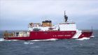
I'm conducting the ecosystem survey in the Arctic Oceanonboard the USicebreaker "Healy" during 5 to 25 August. Hopefully the survey will going well. I will update the process, if possilbe.
That is the question I need an answer for. A few days ago, I was convinced by a Nature paper that the tropical Indian Ocean has undergone changes that are consistent with what scientists expected from a warming climate. Today, I found two papers that emphasize decadal variability, at least at 32S. (Why 30S? That's a survey line that we have some data to work on.) I need to know the answer quickly, because I have a proposal deadline. So, I emailed the first author in UK. Hope she will answer me soon...
I will be giving a seminar at Xia Da, and Bei Da. I will share my experience in the past four year, from a new comer (ecosystem modeling) to an expert (sort of). Oxygen Minimum Zones in the Northern Indian Ocean Time: 10:00 am on April 25th Place: Room B206 State Key Laboratory of Marine Environmental Science (MEL), Xiamen University Time: 10:00 am on May 3rd Place: Room 576 Department of Atmospheric and Oceanic Sciences Peking University
It's only 73F in my living room at 7:23 am. I have to put socks on. So, I would say it's a cold winter day in Hawaii. However, I will never agree with those people who think burning oil, gas, and coal is ok. It is NOT ok. One third of the CO2 we release into the atmosphere is absorbed by the world ocean. So, the ocean is becoming more acid. Read about ocean acidification, and you will be as worried as most oceanographers about the future of the Earth.
ZHEJIANG OCEAN UNIVERSITY AND BLUE REVOLUTION HAWAII SIGN MOU http://bluerevolutionhawaii.blogspot.com/2011/06/zhejiang-ocean-university-and-blue.html 4. Zhejiang Ocean University was formed in 1988, but already has 15,000 students. A new campus at the coastline is being constructed. I would not be surprised if this someday becomes the pre-eminent ocean institution for the country. A sister city relationship is being discussed between Zhoushan and Honolulu. Hawaii's primary link to China could well in time become these islands, located across the bay and south of Shanghai, for we have very similar interests and are the only island states of our respective countries. ps. I think there are some inaccurate predictions and mistakes in this Blog.
Joint Oceanography-IPRC Seminar Zuojun Yu Associate Researcher International Pacific Research Center University of Hawaii "Oxygen Minimum Zones in the Northern Indian Ocean" Abstract: In the tropics, mid-depth oxygen minimum zones (OMZs) are located in poorly ventilated regions below the thermocline. As a result, surface production can contribute to the strength of OMZs remotely as well as locally. In the northern Indian Ocean, OMZs can be found in the Arabian Sea (ASOMZ) and the Bay of Bengal (BBOMZ), consistent with the distribution pattern of ventilation ages. The intensity of the BBOMZ is moderate, while permanent suboxic condition (O2 ~5 μM) is reached in the Arabian Sea, clearly due in part to local production. The ASOMZ is the second most intense OMZ in the tropical ocean, with near-total depletion of oxygen at depths from 200-1000 m. The lower part of the ASOMZ (below 400 m) indicates a northward intensification, in agreement with the ventilation age revealed by CFC ratio. The upper part of the ASOMZ (above 400 m), however, appears east of the most productive regions along the western boundary, and there is no consensus about what causes this “eastward shift.” In contrast, much less is known about the distribution of BBOMZ. In both sub-basins, the relative roles of physical versus biological processes in generating OMZs have not been fully determined, in part because ocean models often fail to reproduce these OMZs. In this seminar, the speaker will present the latest results of their findings. Thursday January 20, 2011 3:00 p.m. MSB 100 http://www.soest.hawaii.edu/oceanography/seminar.html
According to TEOS-10 , the official source of information about the Thermodynamic Equation Of Seawater - 2010 (TEOS-10). A significant change compared with past practice is that TEOS-10 uses Absolute Salinity SA (mass fraction of salt in seawater) as opposed to Practical Salinity SP (which is essentially a measure of the conductivity of seawater) to describe the salt content of seawater. Ocean salinities now have units of g/kg. ... Importantly, while Absolute Salinity (g/kg) is the salinity variable that is needed in order to calculate density and other seawater properties, the salinity which should be archived in national data bases continues to be the measured salinity variable, Practical Salinity (PSS-78). To avoid confusion while the use of Practical Salinity in scientific publications is phased out, published values of salinity should be specifically identified as being either Practical Salinity with the symbol SP or Absolute Salinity with the symbol SA. The following news came via US CLIVAR office: Replacement of the EOS-80 definition of Seawater properties with TEOS-10 SCOR/IAPSO Working Group 127 on the Thermodynamics and Equation of State of Seawater has recommended the adoption of a new thermodynamic description of the properties of seawater, called the International Thermodynamic Equation Of Seawater 2010 (TEOS-10 for short). This thermodynamic description of seawater properties, together with the Gibbs function of ice, has been endorsed by SCOR and IAPSO and has been adopted by the Intergovernmental Oceanographic Commission (IOC) at its 25th Assembly in June 2009 to replace EOS-80 as the official description of seawater and ice properties in marine science. The TEOS-10 computer software, the TEOS-10 Manual and many other documents may now be obtained from www.TEOS-10.org A notable difference of TEOS-10 compared with EOS-80 is the adoption of Absolute Salinity to be used in scientific journals to describe the salinity of seawater and to be used as the salinity argument in the TEOS-10 algorithms that give the various thermodynamic properties of seawater. Note, however, that we strongly recommend that the salinity that is reported to national databases remain Practical Salinity as determined on the Practical Salinity Scale of 1978 (suitably updated to ITS-90 temperatures as described in the TEOS-10 Manual). The practice of storing one type of salinity in national databases (Practical Salinity), but using a different type of salinity in publications (Absolute Salinity), is exactly analogous to our present practice with temperature; in situ temperature is stored in databases (since it is the measured quantity), but the temperature variable that is used in publications is a calculated quantity, being either potential temperature or Conservative Temperature.
 标签: Ocean