�ձ��о��ƴ������������������йأ���ϫ�����������ֵ���� �ձ��о��ƴ������������������й� 2016��09��14�� 13:27:36 ��Դ�� �»��� �����»��綫�����£����յ磨�����壩�ձ�������ѧһ���о�С�����·�����һ���о�����ƣ��������������������йأ��ϸߵĵ������������������ǿʱ������ ����������ѧ��������ѧ���ھ����ܵ��˶ԣ�������ȫ�����ģ����������ϵ���͵�ʱ�ij�ϫ��������˱ȶԡ�������֣������Σ����������ϵ����У��У������Ƿ����ں�ˮ�߳�ǰ��Ҳ��������������ǿʱ�ڡ�����������ӡ�����������Ŵ��������ͣ����������ձ��������ʾ�������Ĺ����ԡ� �����о�С�������Ϊ����������������ˮˮλ�仯��ͬ��Ҳ��Եؿ�ѹ������Ӱ�죬��λÿ�仯������ѹǿ��Լ��䶯����ǧ������Ȼ���ֱ仯������ͷŵ�������ȷdz����������ܳ�Ϊ�˴ٳɴ����ġ����һ�����ݡ��� ��������о��ɹ��ѷ�����Ӣ������Ȼ�������ѧ����־������ϡ� http://japan.xinhuanet.com/2016-09/14/c_135686947.htm NATURE | NEWS Sharing Print Email Share/bookmark Moon��s pull can trigger big earthquakes Geologic strain of tides during full and new moons could increase magnitude of tremors. Alexandra Witze 12 September 2016 Article toolsRights Permissions Joe Raedle/Getty Images The seaside town of Pelluhue, Chile, in 2010 after a magnitude 8.8 earthquake and the resulting tsunami. Big earthquakes, such as the ones that devastated Chile in 2010 and Japan in 2011, are more likely to occur during full and new moons �� the two times each month when tidal stresses are highest. Earth��s tides, which are caused by a gravitational tug-of-war involving the Moon and the Sun, put extra strain on geological faults. Seismologists have tried for decades to understand whether that stress could trigger quakes. They generally agree that the ocean��s twice-daily high tides can affect tiny, slow-motion tremors in certain places, including California��s San Andreas fault1 and the Cascadia region2 of the North American west coast. Related stories Chinese data hint at trigger for fatal quake Hurricane may have triggered earthquake aftershocks Floods linked to San Andreas quakes More related stories But a new study, published on 12 September in Nature Geoscience3, looks at much larger patterns involving the twice-monthly tides that occur during full and new moons. It finds that the fraction of high magnitude earthquakes goes up globally as tidal stresses rise. Satoshi Ide, a seismologist at the University of Tokyo, and his colleagues investigated three separate earthquake records covering Japan, California and the entire globe. For the 15 days leading up to each quake, the scientists assigned a number representing the relative tidal stress on that day, with 15 representing the highest. They found that large quakes such as those that hit Chile and Tohoku-Oki occurred near the time of maximum tidal strain �� or during new and full moons when the Sun, Moon and Earth align. For more than 10,000 earthquakes of around magnitude 5.5, the researchers found, an earthquake that began during a time of high tidal stress was more likely to grow to magnitude 8 or above. Breaking point The Asahi Shimbun via Getty Images A lone pine tree that survived the 2011 earthquake and tsunami in Japan. ��This is a very innovative way to address this long-debated issue,�� says Honn Kao, a seismologist at the Geological Survey of Canada and Natural Resources Canada in Sidney. ��It gives us some sense into the possible relationship between tidal stress and the occurrence of big earthquakes.�� Perhaps the miniscule added strain of tides, he says, could be the final factor that nudges a geological fault into rupturing. The current study will not be the final word on the matter, adds Kao. There are just too many factors that contribute to triggering an earthquake �� such as how stress transfers within the ground to cause a geological fault to move �� to untangle exactly what role tides might have. But ��the results are plausible��, says John Vidale, a seismologist at the University of Washington in Seattle who helped to debunk some of the more tenuous tide�Cearthquake claims4. ��They��ve done a very careful job.�� The discovery does not affect how societies should prepare for possible earthquakes, says Ide. Even if slightly enhanced by the tides, the probability of a quake happening on any particular day in an earthquake-prone region remains very low. ��It��s too small to take some actions,�� he says. Ide is now looking at an additional list of earthquakes that occur where plates with oceanic crust plunge beneath continental crust, to see if the pattern holds up there as well. Nature doi:10.1038/nature.2016.20551 Tweet Facebook LinkedIn Weibo Wechat References Thomas, A. M., Nadeau, R. M. B��rgmann, R. Nature 462, 1048�C1051 (2009). ArticlePubMedChemPort Show context Lambert, A., Kao, H., Rogers, G. Courtier, N. J. Geophys. Res. 114, B00A08 (2009). Show context Ide, S., Yabe, S. Tanaka, Y. Nat. Geosci. doi:10.1038/ngeo2796 (2016). PubMed Show context Kennedy, M., Vidale, J. E. Parker, M. G. Seismo. Res. Lett. 75, 607�C612 (2004). Article Show context Related stories and links From nature.com Chinese data hint at trigger for fatal quake 10 September 2014 Hurricane may have triggered earthquake aftershocks 19 April 2013 Floods linked to San Andreas quakes 06 January 2010 Typhoons trigger gentler tremors 10 June 2009 Author information For the best commenting experience, please login or register as a user and agree to our Community Guidelines. You will be re-directed back to this page where you will see comments updating in real-time and have the ability to recommend comments to other users. Comments http://www.nature.com/news/moon-s-pull-can-trigger-big-earthquakes-1.20551 ��ϫ�����������ֵ���� ���� 1342 ���Ķ� 2011-5-16 05:56 |���˷���:�Ƽ�����|ϵͳ����:���Ľ���|�ؼ���:���� ��ϫ �Ƽ���Ⱥ�� ��ϫ�����������ֵ���� ��ѧ�飬��� 2005�����������ߵ���ֵ����õ�һЩ������֤���½������ȥ���ǽ���֪��̫�����ӻ��11a���꣩��22a���ڣ�ʵ���ϳ�ϫҲ��11 a��22 a���ڡ� �Ĵ���������ѧ��E. �������ر����ġ�������̺�����仯���У��й���������ѭ���ļ�¼75�� ����ϫ��������������ѭ���ļ�¼�кܺõĶ�Ӧ�� ���볱ϫ������ͬ����66�ռ88%��������ϫ��Ӱ����������ѭ������Ҫ���ء���ϫ�Ķ����������ܵ����ǵĹ�ͬ���ں������������ص���ʱ�����ֵø�Ϊǿ�ң���11a��22a�����dz�ϫ��̫����Ĺ�ͬ���ã�ռ75����������ѭ����¼�е�17� ��1 ��ϫ��������Ա� �ݼ��ֵļ��㣬��Լ��1425�꼴С���ڵ�ĩ�ڣ���ϫ�ﵽ�����ֵ�������Ժ�������ֱ��3100�곱ϫ�ִﵽ���ֵ ����15��17����С�����кܶ�ǿ�����Ӧ���й��������������ڣ�������200���꣬��䷢����4��8������7��7����������ƽ����������85�꣬δ�����κδ���6���ĵ��� ���˺�Խ��Խ����˷����˳�ϫ�����Ķ�Ӧ��ϵ�� ��Ԫ�����������������ڿ���Ӱ�����ĸ�������ۣ��������������Ϊ�������س������´��ӣ���������λ�ñ仯����� ����Ʒ�ʣ�1994���ͺ��Ե��ˣ�2003���ֱ�ָ��������������Ե�18.6�곱ϫ���ڣ�����Ϊ�ҽ������� �� ���Ե�����ϸ������20��������ǿ��Ⱥ��ʢ˥�����ı���������ָ�������׳ཻ�ǣ����������γ�ǣ��仯�����Ľ��㳱������Ӱ��������ڻ��һ��ԭ�������������20�����������ϵ�4��M��6.7��ǿ���Ծ����3��ʼ���������׳ཻ�Ǽ����������꣬��һ�������Ծ�ڲ�����ˣ������ܸ��ʴ�80%�����⣬����̫������ǵ���������11������ڣ��Ա�̫���������������ƽ����������������������ǿ�Ȼ���ƽ�����ߣ���������������Сʱ������ǿ�����ݴˣ���������20�������������������������4��11�����ڵ����ƣ���������һ�������Ծ���������ʱ�������������2����������������Ŀǰ�����׳ཻ�DZ仯��̫������ƣ�������Ϊ������һ�������Ծ�ڿ��ܿ�ʼ��2006/2007�ꡣ���Ǹ��ݵ���11��������ͬ��λ���ƽ��ǿ��������Ԥ����2005�갴��ǰ7��11������ͬ��λ���������ǿ��ƽ�����㣬����Ϊ5.69�����£��Դ��ڵ�ˮƽ��ڣ���2006��ĵ���ǿ�����������6.37�����£�Ӧ�������ǵľ����������ص���2007�꣬������������λ������ǿ�ҵ���ƽ�����ѽӽ�6.7������������������������һM���ڵ���6.7��ǿ���Ծ�ڵĿ�ʼ�꣬�����ܱ���7�����𣨸��ʴ�43%�� �� ǿ��ϫ���Լ������������������˷�����1977��2000���ȫ��2000���5.5�����ϵĵ��𣬷������ҵij�ϫ��dz�����ʩ�����㹻��ѹ���Ӷ����������𡣵���ϫ�ܴﵽ��Լ2��3��ʱ��3/4�ĵ��ᷢ��������ϫԽС�������ĵ���Ҳ��Խ�� �� ��ѧ�����ָ������Բ�ĽǴ���90�ȵ�̫ƽ��ؿǣ�����̫ƽ��������γ�60cm�ij�ϫ�߶Ȳ��ϫ���ɵ�����ǰ��ľ����˶�����ϫ�����̫ƽ��ؿ����ΰ��˶��ɲ����ĵ�ЧӦ��Ϊp = 108 N�����ǻ�̫ƽ�������γɵ�ԭ��֮һ���������ȵ���ʱ������ŷ�ʹůˮ�����ڳ����̫ƽ����ˮ�����ڳ����̫ƽ���²�Ϊ3-6�棬�߶Ȳ�Ϊ40-60cm�����������ŵ����ʱ�����������ת�����ڵؿǾ���ԭ������Ƿ��������13-20cm�ľ���仯����ǿ�˳�ϫ����Ĵ���ؿ����ΰ��˶������Ƕ����ŵ��������ǰ��̫ƽ����������Ծ��ԭ�����п���������������� �� 2009��2��25������ѧ��M��tivier�����ڡ���������ǿ�ѧͨѶ����Earth and Planetary Science Letters��������Ϊ ��������峱���������֤�ݡ������£�Ϊ��ϫ���������ṩ���µ�֤�ݡ�Ӧ��ȫ�����ĵ���Ŀ¼������442412���¼�����M��tivier���˵õ����峱λ��������¼�ʱ�������Ķ�Ӧ��ϵ��99%�����Ŷȣ�������ʯȦ������ѹ������ʱ���������ڹ��峱ʹ����������ʱ�̡����Ƿ��֣����峱�ȴ������ͺ���������Ŀ����Ը��� ����֤�ݵ���Ҫ���������ɵģ���ǿ���˵�����峱�͵����ϵ�� ��һ���о����������𡢳�ϫ������仯���Ӱ��ģ������ֺ��͵����ֺ�����������������λ���ֺ��� �� �ο����� 1. E. ��������. ������̺�����仯. ����: ��ѧ������, 2004. 11 2. ���, ��ѧ��. �Ĵ������ļ���ѩ���ϼ�������������. ��������ѧ��չ, 2007, 22(5): 1680~1685 3. Charles D. Keeling and Timothy P. Whorf. The 1800-year oceanic tidal cycle: A possible cause of rapid climate change . PNAS, 2000, 97(8): 3814-3819 4. ���ڽ�, ��Ʒ��. �ֽ�ؿ��˶����� . ����: ���ʳ�����, 1995.10, 99-102. 5. �����, ��Ԫ��. ���������������������ϵ�ļ��鼰Ӧ�� . ����, 1993, (3): 32-37. 6. ��Ʒ��. 18.6a�����ֻؼ�������̽ . ��������ѧ��, 1994, 37��3��: 362-369. 7. ����, �Ժ���, �ͺ�ΰ. ����Ӱ��������δ�����������о� . ��������̨̨��. 2003,��4��:49-55 8. Elizabeth S. Cochran, John E. Vidale, and Sachiko Tanaka. Earth Tides Can Trigger Shallow Thrust Fault Earthquakes . Science. 2004, 306: 1164-1166. 9. ��ѧ��, ���ӱ�, ����, ����Դ. ǿ��ϫ���������ɽ�����֤�� . ��������ѧ��, 2004, 47��4��: 616-621. 10. M��tivier, Laurent; de Viron, Olivier; Conrad, Clinton P.; Renault, St��phane; Diament, Michel; Patau, Genevi��ve. Evidence of earthquake triggering by the solid earth tides . Earth and Planetary Science Letters, 2009, 278(3-4): 370-375. 11. ��죬��±���ѧ�顣����ͳ�ϫ�������仯��Ӱ�졣��������ѧ����2011��54��4����926-934. http://www.geophy.cn/CN/volumn/home.shtml 12. ��ѧ�飬��졣����������λ��ʱ�ڵ��ֺ����������߽������࣬���Ŵ�������ХӰ���й����������ij����о������й����ֺ���ѧ�����ֻ����ļ�����������磬2007��200-204�� http://blog.sciencenet.cn/blog-2277-444525.html 2016����2018���ش�����б����ڽ�������̽� ���� 608 ���Ķ� 2016-9-3 06:04 |���˷���:�Ƽ�����|ϵͳ����:�۵�����|�ؼ���:�ش���� ����������λ�� �����ŵ ������ ������γ�� �Ƽ���Ⱥ�� 2016����2018���ش�����б����ڽ�������̽� 2016 ���� 2018 ���ش�����б����ڽ�������̽� ��ѧ�� �ش����ķ������� ���з���������������λ��ʱ�ڵ�ǰ 17 �ꣻ һ��������ŵ�������ȹ����� һ����������γ�Ǽ�ֵ������ һ����ɺ����ˮ���� ��γ��������������ر��� 2004-2012 �꣨���� 1 ���� �� 1 �������ش��������ͳ�ƹ��ɺ�Ԥ�⣺ 2016 ���� 2018 ���ش�����б����ڽ�������̽Ρ� �� 1 �������س���̫�����س��������ڵ��ӣ���죬 2009 ����ѧ�飬 2016 �� ���ص� �� �� ��ϫǿ�� �����ŵ�꣨ E �� �� �� �� �� �� �� w ǿ s �������꣨ L �� �� 1946-1976 ������������λ��ʱ�ڣ� 1947 1 06 7 22 ss 1948 1 26 11 26 sss 1949 1 17 15 29 s L 1950 1 13 4 18 ww L ������γ�Ǽ���ֵ 1951 1 06 8 23 s E ������γ�Ǽ���ֵ 1952 1 26 12 27 ss E �� �ش���� 1953 1 17 15 30 s E 1954 1 10 5 19 ww L 1955 1 06 8 24 s L 1956 1 26 13 27 ss L 1957 1 17 1 16 ss E �� �ش���� 1958 1 09 6 20 0 E 1959 1 06 9 25 0 ���� ������γ�Ǽ�Сֵ 1960 1 26 14 28 s ���� �ش���� ������γ�Ǽ�Сֵ 1961 1 17 2 17 sss ���� ������γ�Ǽ�Сֵ 1962 1 08 6 21 s ���� 1963 1 04 10 25 www E �ش���� 1964 1 26 15 29 0 E-L �� �ش���� 1965 1 17 3 17 sss L-E �ش���� 1966 1 08 7 21 ss E 1967 1 01 11 26 w L 1968 1 25 16 30 ww L ������γ�Ǽ���ֵ 1969 1 17 4 18 ss E ������γ�Ǽ���ֵ 1970 1 08 8 22 sss E-L ������γ�Ǽ���ֵ 1971 1 28 11 27 ss L 1972 1 22 1 16 30 www E 1973 1 17 4 19 s E 1974 1 08 8 23 sss L 1975 1 28 12 27 ss L 1976 1 20 1 17 31 0 L-E �� 1977-1999 ����������ůλ��ʱ�ڣ� 1977 1 16 5 19 0 E 1978 1 08 9 24 ss ���� ������γ�Ǽ�Сֵ 1979 1 28 28 13 sss E ������γ�Ǽ�Сֵ 1980 1 20 2 18 s ������γ�Ǽ�Сֵ 1981 1 15 06 20 ww 1982 1 08 10 25 s E 1983 1 28 14 29 ss E 1984 1 20 03 18 s 1985 1 12 21 07 ww 1986 1 08 10 26 s E ������γ�Ǽ���ֵ 1987 1 28 29 15 ss E ������γ�Ǽ���ֵ 1988 1 20 19 04 ss ������γ�Ǽ���ֵ 1989 1 11 08 22 0 1990 1 08 27 11 0 1991 1 28 16 30 s E 1992 1 20 5 20 sss E 1993 1 10 23 8 s E 1994 1 06 12 27 www E 1995 1 28 31 17 0 EL ������γ�Ǽ�Сֵ 1996 1 20 20 6 sss L ������γ�Ǽ�Сֵ 1997 1 10 9 23 ss L,E ����������γ�Ǽ�Сֵ 1998 1 03 13 w E,L 1998 1 30 28 s L 1999 1 27 17 2 ww L �� 2000-2030 ������������λ��ʱ�� �� 2000 1 20 7 21 ss L 2001 1 10 24 10 sss 2002 1 02 13 29 s E 2003 1 24 3 18 www 2004 1 20 22 7 s 2005 1 10 10 25 sss �ش���� ������γ�Ǽ���ֵ 2006 1 02 31( ���� 12 �� ) s E ������γ�Ǽ���ֵ 2007 1 22 19 3 0 L �ش���� L ������γ�Ǽ���ֵ 2008 1 19 8 22 0 2009 1 10 26 11 ss E 2010 1 02 15 1 ss L �ش���� 2011 1 22 4 20 s L �ش�ǿ�� 2012 1 18 9 23 www L �ش�ǿ�� 2013 1 10 12 27 s 2014 1 02 1 16 31 ss ������γ�Ǽ�Сֵ 2014 1 30 1 16 31 ss 2015 1 22 05 20 s E ������γ�Ǽ�Сֵ 2016 1 15 10 24 ww L �䶬 �ش�ǿ�� �� ������γ�Ǽ�Сֵ 2017 1 10 12 28 s L �䶬 �ش�ǿ�� ? 2018 1 02 02 17 sss E �ش���� ? 2018 1 30 17 31 ss E �ش���� E �� ע �� ����ͬʱ�����������س������´�Ϊ��ǿ��ϫ sss �� ���һ��Ϊ��ǿ��ϫ ss �� �������Ϊǿ��ϫ s �� �������Ϊһ�㳱ϫ 0 �� �������Ϊ����ϫ w �� �������Ϊ������ϫ ww �� �����������Ϊ������ϫ www ���ش����Ϊ���귢�� 9 �����ϵ��𡣣���ʾԤ�⡣ ���ȣ� 2006a �� 2006b �� 2011 ��ָ���� 8.5 �����ϵ����з���������������λ��ʱ�ڣ��ǵ����Ծ����Ҫ��־�� 2000 ������� PDO ��λ��ʱ�ڣ� 2000-2030 ����ȫ��ǿ�𱬷�ʱ�ں͵����ڡ� �� 2 1890 �������ش�����Ծ�ں��������ף� PDO ����λ���Ӧ��ϵ ��� 8.5 �����ϵ������ 9 ������ ������� PDO ʱ��λ�� ������ů ���� ȫ�� �й� 1890-1924 6 �� 4 �� 1 0 1890-1924 �� ������ ��Ծ�� 1925-1945 1 �� 1 �� 0 0 1925-1946 ů ��ů�� 1946-1977 11 �� 7 �� 1 4 1957-1976 �� ������ ��Ծ�� 1978-1999 0 �� 0 �� 0 0 1977-1999 ů ��ů�� 2000-2012 6 �� 6 �� 0 2 2000-2030 �� �����ڣ� ��Ծ�� ע : �ش����Ϊ Ms 8.5 ������ǿ��������Ϊ�������ݣ�����ʾԤ�� ������ 2006 ��ȷ���ĵ����Ծ���ж������ڱ�ѧ������ܣ��õ���ز��ź�ר�ҵ���ͬ��Ŀǰ 8.5 ������ǿ������ 2006 ��� 2 �����ӵ� 6 �Ρ���һ������ 2016-2018 �껹���������ӡ� ��ѧ��ȣ� 2008 ��ָ���� 1947-1976 ������������λ��ǰ 17 ���� 7 �� 8.5 ������ǿ���б����� �����Ʋ⣺ 2000-2030 ������������λ��ǰ 17 ��Ϊ 8.5 ������ǿ���б���ʱ�ڡ� 2016 ���� 2018 ���ش�����б����ڽ�������̽Ρ� http://blog.sciencenet.cn/blog-2277-24736.html �ο����� 1. ��죬��ѧ�顣���������ס���λ��ʱ�ڵ�ȫ��ǿ����ֺ�����������ѧ���� 2006 �� 28 �� 1 ���� 95-96 2. ��죬��ѧ�飬���ơ� 2004 �� 12 �� 26 �� ӡ�����Х��ȫ����¡���������ѧ��չ�� 2006 �� 21 �� 3 ���� 1023-1027 3. ��죬��±���ѧ�顣����ͳ�ϫ�������仯��Ӱ�졣��������ѧ���� 2011 �� 54 �� 4 ���� 926-934. 4. ��ѧ�� , ��� . ȫ������ش����Ƶ���� . �ٿ�֪ʶ 2008.07 �ϣ� 8-9. 5. ��ѧ�飬��졣�������ںͺ�����¼�˵����֤�ݡ���������ѧ���� 2005 �� 27 �� 4 ���� 400 �� 398 �� http://blog.sciencenet.cn/blog-2277-1000500.html
�ձ��ش����ij����������� ��ѧ�� ѧ�߳����ͨ�������ҹ���������ר������������Ԥ���ʱ����˹��Ӣ���Ŀ�ѧ������ΪԤ�����æ�ò����ֺ������Ǹ��ݵ����Ͽյĵ���źű仯�жϣ������������ڷ����������� http://blog.sciencenet.cn/home.php?mod=spaceuid=39626do=blogid=422812 More ominously in this report are Russian scientists confirming the independent analysis of New Zealand mathematician and long-range weather forecaster, Ken Ring, who predicted the deadly Christchurch quake and this week issued another warning of a quake to hit on or about March 20th��3��20�գ�. http://www.realnewsreporter.com/?p=843 ����Ҳֻ�еȵ�3��20�ղ�֪��������ô���� ��������ר��2008������ʮ���շ�����һ�ݵ���Ԥ�ⱨ��ָ����δ����ʮ���ڣ��ϼ��ݵ��������п��ܡ�����һ�δ���� �й�����ֵ����о�������ר�����һ�ڡ�2010����Ԥ��ѧ�����ֻ����ļ�����ָ����2010��2��27������8.8�������ķ������ܱ�ʾ�������ľ���Ⱥ���߳�ʱ�εĿ�ʼ��ֵ���ر��ע������������ѧ�ҵ�Ԥ����һ�¡� ����2008����ش�������Ʒ����� ������һ�������壬һ��������Σ�Ϊ��һ���ĵ�������ṩ������ ���������ǿ���·��ͼ����1�ĵ�����й���ʼ���ֻص��й�����һ�պ�·��Ϊ��һ��ǿ��ķ����ṩ���м�ֵ�������� ��ظ�ԭ�������ݼ�����30������ڻ���������Ȼ�ǵؿǾ�����ǿ�ҵĵ������й������½���ؿǵĸ�������½�����õ����µ�����������������½�����Ӵ��ĵ�������ǿ�𡣵���ǿ����ȫ��Χ�ģ��鲼����̫ƽ���ӡ������������һ��ѭ���� ����������ɳ�������һ��8������ǿ��ͱض�������½�����Ӵ�����·��ͼ��Σ���Ե�����Ϊ���ձ���ӡ�ᡢ����Ӱ뵺������γ�ȵ������ϱ���̫ƽ���غ����������У��ձ�������˹��ӡ�ᷢ��ǿ��ķ������������ϱ���̫ƽ���غ������� http://www.sciencenet.cn/blog/user_content.aspx?id=27377 http://blog.sciencenet.cn/home.php?mod=spaceuid=2277do=blogid=27387 http://bbs.sciencenet.cn/home.php?mod=spaceuid=2277do=blogid=421387 ����·��ͼ���ձ��������һ���ش�����λ�þͺ�����ˣ������е�һ��������˹��Ȼϣ��������������Ҳ�ܼ�ӡ���ѷ�����һ��9.1����������������8.8������ʣ�µĶ���˹������������Ǻ��ߡ� 1952�ꡢ1957�ꡢ1960�ꡢ1964��4��9�������ش����ͷ�����1947-1976������������λ��ʱ��ǰ17�꣬�ֱ��ڶ���˹����ӡ���������˹�ӡ���������������˹�ӣ������������������������Ļ�̫ƽ������������Ϊ�ػ�̫ƽ������˳ʱ����ת���ձ��ǵ�����Ƶ���Ĺ��ң����ձ���9���ش����Ŀ��������ݵ���������ۣ�9�����������ձ��dz����������۵Ľ�����ձ��ȴ������������һ�������ͣ�������ٻ���ͬ���������ƽ�������¡� 2011��3��11���ձ�������9���ش���������������̫ƽ������9������Ŀհף��������ϲ��ͰĴ����Ƕ�����̫ƽ�������⣬�������9�������ش�����ڻ�̫ƽ������������һ��ѭ���������ϲ��ͰĴ����Ƕ���̫ƽ��������9���ش����Ŀ��������ڷ���9�������ش����ķ��ա� http://bbs.sciencenet.cn/home.php?mod=spaceuid=2277do=blogid=422124 http://blog.youguow.com/index.php?uid-44256-action-viewspace-itemid-38441 ���������������ȷʵ���ڣ�����˹����ר�ҵ�Ԥ�ⲻ���ݡ�������һ�귢������9����������Ժ�С����ʷû�������� References���ο����ף� �����, ��Ԫ��. ���������������������ϵ�ļ��鼰Ӧ�� . ����, 1993, (3): 32-37. ��Ʒ��. 18.6 a�����ֻؼ�������̽ . ��������ѧ��, 1994, 37(3): 362-369. �� ��, �Ժ���, �ͺ�ΰ. ����Ӱ��������δ�����������о� . ��������̨̨��, 2003, (4): 49-55 Cochran E S, Vidale J E, Tanaka S. Earth Tides Can Trigger Shallow Thrust Fault Earthquakes . Science, 2004, 306: 1164-1166. ��ѧ��, ���ӱ�, �� ��, ��. ǿ��ϫ���������ɽ�����֤�� . ��������ѧ��, 2004, 47(4): 616-621. M��tivier L, DE Viron O, Conrad C P, et al. Evidence of earthquake triggering by the solid earth tides . Earth and Planetary Science Letters, 2009, 278(3-4): 370-375. �㶫�Ƹ�����1.9������ ���ֵ�������� http://www.sina.com.cn 2011��03��19��03:21 ������-�����ձ� �������ֵ�������� δ�����Ա���� ���������Ƹ�Ѷ (�����ڸ��� ͨѶԱ��˸)�ݹ㶫ʡ����̨���ⶨ������ʱ��2011��3��18��9ʱ38�֣��ڹ㶫�Ƹ�(����112.0��γ22.9)������M1.9���𡣵ص����Ƹ���������1~2�����ɽ������Դ��ȴ�10��������ư���ǰ������ʢ���������ӿڲ��ֵ�������У�δ������Ա������ ��������������������������о������Իζ�������������ƣ����س�����ɽ·һ������������������������һ���� �����Ƹ���������ѧУ���ڵ�һʱ����֯��ɢѧ�����ٳ����ա�����һСһ����ʦ˵������ʱ����ȫ�����ˣ�֮��ѧУ���Ⱦͽи�������δ�ѧ�����ٳ���ʦ�����ڲٳ�ͣ����Լ���Сʱ�������е�û���ּ��лص������ϿΡ�������Сѧ����ʾ��ƽʱѧУ�����й���εĵ�������������Ҳѵ�����أ���η�������Ҳ�����¡� �����˴ε�����Ȼ����������У������˹㷺��ע������״�绰��ʡ����֡��Ƹ��е�����ѯ������� ����ʡ����֣� �����Ƹ��������ƻ��Ե��� ��������������������Ӧ������������Ȳ��ŵ�λͨ�������������桢������Ϣ�Ȱ취��������������Ѹ�١���ʵ��֪������������˹����������ǣ��������δ������ܵ�Ӱ�졣 ������Ϥ��ʡ��������ڼ�ǿ�������ݷ����������������������жϣ��Ƹ��н��ڲ��ᷢ���ƻ��Ե��� http://news.sina.com.cn/c/2011-03-19/032122142509.shtml
�����������ش���� Ī˹�Ƶ�������ѧ�о������վ������ı��棨3-12���о���˵����������δ������(14��)�ڽ����������Ե��ش����Σ������ע���ص����������ī���磬��������������������������������������ϲ㹹��������� http://sinaurl.cn/hbFWyh http://www.realnewsreporter.com/?p=843 EARTHQUAKE WARNING FROM RUSSIAN INSTITUTE of PHYSICS of the EARTH Posted by Real News Reporter on March 12th, 2011 A new report released today in the Kremlin prepared for Prime Minister Putin by the Institute of Physics of the Earth, in Moscow, is warning that the America��s are in danger of suffering a mega-quake of catastrophic proportions during the next fortnight (14 days) with a specific emphasis being placed on the United States, Mexico, Central America and South American west coast regions along with the New Madrid Fault Zone region. This report further warns that catastrophic earthquakes in Asia and the sub-continent are, also, ��more than likely to occur�� with the 7.3 magnitude quake in Japan today being ��one of at least 4 of this intensity�� to occur during this same time period. Raising the concerns of a mega-quake occurring, this report says, are the increasing subtle electromagnetic signals that are being detected in the Earth��s upper atmosphere over many regions of the World, with the most intense being over the US Western coastal and Midwest regions. Important to note are that Russian and British scientists are at the forefront of predicting earthquakes based on these subtle electromagnetic signals and have joined in an effort to put satellites in space to detect more of them. More ominously in this report are Russian scientists confirming the independent analysis of New Zealand mathematician and long-range weather forecaster, Ken Ring, who predicted the deadly Christchurch quake and this week issued another warning of a quake to hit on or about March 20th.
�Ĵ����������Ϣ��������������ǿ���Ĵ��ന���緢�� 3.9 �����𡣾ݵ���̨���ⶨ������ʱ�� 2008-09-26 18:31:59.9 ��������ǿ���Ĵ��ന���� ( ��γ 32.8, ���� 105.6) ���� 3.9 ������ http://www.eqsc.gov.cn/manage/dailyReport.jsp?id=d52c2c5e-114c-4305-a7fa-435825f2f14e ���� 2008 �� 9 �� 26 �� ָ����ÿ������ 5 �����ϵ������� ��ɫ�� ������ظ�ԭ�ܱߵ������½����Ĵ������ϡ��ຣ�����ࡢ���ĵȵ����� ��ɫ�� �����ᷢ�������ĵ������ص��������Ϊ���ܱߵ����ǰ�ס� 2008 �� 9 �� 25 �� 6.0 �������������տ�������ٰ��ص���ֵ�ù�ע �� ����ʱ�� 2008-09-26 18:31:59.9 ��������ǿ���Ĵ��ന���� ( ��γ 32.8, ���� 105.6) ���� 3.9 ����������Ȼ��֤���ҵ��Ʋ⣬������������ 9 �� 27 �� ӡ����˹�����뷢�� 5.7 ������ӡ����ư�Ⱥ������ 4.4 ������ 26 �������ϲ����� 4.9 ������ӡ���������Ż���ԣ����ǵ�����ǿ������ֵ�ù�ע �� Recent Earthquakes 09/26/2008 M 5.7, Carlsberg Ridge ( ӡ����˹������ 3.091 N, 65.442 E) 09/24/2008 M 5.9, western Xizang �� �����������տ�������ٰ��� 30.927N, 83.449E �� 09/23/2008 M 6.4, off the coast of Colima, Mexico ( ī���磬 17.658N, 105.507W) 09/22/2008 M 5.7, Hokkaido, Japan region( �ձ� �� 41.603N, 140.457E ) 09/20/2008 M 5.2, Northwest Territories, Canada �����ô� 63.601N, 129.157W �� http://www.iris.edu/hq/audience/public/earthquakes ����ص� ����ʱ�� γ�� ���� ��� �� (M) �в� Nicobar Islands, India Region 2008-09-27 03:25:49.330 6.23 93.82 213 4.4(mb) 1.6 Carlsberg Ridge 2008-09-27 02:46:29.060 3.76 65.62 30 5.7(Mw) 1.9 Sichuan , China 2008-09-27 01:48:57.160 31.20 103.75 10 3.2(ML) 3.4 Near East Coast of Honshu , Japan 2008-09-27 00:53:34.260 40.71 142.59 91 5.4(Mw) 1.5 Southern Iran 2008-09-26 23:52:57.160 28.58 58.32 220 4.9(mb) 1.1 Sichuan , China 2008-09-26 18:32:03.850 32.79 105.66 10 4.5(Mw) 1.5 Andreanof Islands , Aleutian Islands2008-09-26 18:23:45.130 51.78 -176.43 10 5.5(mb) 0.9 New Britain Region, P.N.G. 2008-09-26 16:49:26.020 -6.58 153.66 21 5.1(mb) 1.6 Fiji Islands Region 2008-09-26 13:49:03.330 -16.83 -178.47 648 5.0(mb) 0.8 Southern Iran 2008-09-26 11:37:29.710 28.50 58.54 328 4.2(mb) 2.4 Xizang , China 2008-09-26 04:17:33.650 30.93 83.74 44 4.6(Mw) 2.0 Southeastern China 2008-09-26 03:08:32.940 30.25 112.18 423 3.1(ML) 1.6 Kyushu , Japan 2008-09-26 03:05:38.220 32.37 130.59 254 4.6(mb) 1.6 Solomon Islands 2008-09-26 01:47:00.550 -7.84 159.55 68 5.0(mb) 1.0 Northern and Central Iran 2008-09-25 23:34:09.330 33.66 58.57 650 4.4(mb) 2.4 Off East Coast of Honshu , Japan 2008-09-25 23:06:33.040 35.96 143.84 93 4.9(mb) 1.9 Off East Coast of Honshu , Japan 2008-09-25 23:06:49.300 36.84 142.21 65 5.0(mb) 1.7 Fiji Islands Region 2008-09-25 20:30:27.710 -20.33 -178.31 507 4.7(mb) 0.7 Xizang , China 2008-09-25 19:19:11.970 30.78 83.43 52 4.1(mb) 2.3 North Korea 2008-09-25 11:34:01.210 39.12 127.64 650 4.4(mb) 2.1 Xizang , China 2008-09-25 09:47:15.280 30.92 83.62 10 5.9(Mw) 2.0 North Pacific Ocean 2008-09-25 06:04:38.200 13.16 -120.57 4.8 (ML) 1.7 Kamchatka Peninsula , Russia 2008-09-25 04:09:19.300 55.72 158.93 395 4.1(mb) 1.5 Hindu Kush Region, Afghanistan 2008-09-25 01:59:27.970 36.11 70.73 51 5.3(Mw) 0.9 Southern Xinjiang , China 2008-09-24 20:53:55.340 35.97 81.29 71 4.1(ML) 2.2 Hindu Kush Region, Afghanistan2008-09-24 20:04:49.230 36.46 70.30 152 5.3(Mw) 1.2 http://bulletin.gddsn.org.cn/seisbulletin/main.seam Date Time UTC Latitude degrees Longitude degrees Depth km Mag. Region name 2008-09-26 18:46:30.1 2.73 N 65.11 E 124 mb 5.2 CARLSBERG RIDGE 2008-09-26 16:53:21.2 40.70 N 142.75 E 5 mb 5.3 NEAR EAST COAST OF HONSHU , JAPAN 2008-09-26 15:52:21.1 27.46 N 56.77 E 35 mb 5.1 SOUTHERN IRAN 2008-09-26 15:05:55.2 39.34 N 37.29 E 7 MD 3.0 CENTRAL TURKEY 2008-09-26 13:50:48.0 37.16 N 38.67 E 7 MD 3.0 EASTERN TURKEY 2008-09-26 12:03:16.1 35.62 N 49.11 E 10 ML 3.5 WESTERN IRAN 2008-09-26 11:00:07.1 35.71 N 49.04 E 18 ML 4.4 WESTERN IRAN 2008-09-26 10:23:44.1 51.77 N 175.28 W 60 mb 4.9 ANDREANOF ISLANDS, ALEUTIAN IS. 2008-09-26 10:19:54.8 35.62 N 6.01 W 5 f ML 2.5 STRAIT OF GIBRALTAR 2008-09-26 09:53:46.8 37.50 N 35.11 E 5 MD 2.9 CENTRAL TURKEY 2008-09-26 08:59:40.2 64.78 N 30.79 E FINLAND-RUSSIA BORDER REGION 2008-09-26 07:23:03.4 42.26 S 173.71 E 30 mb 4.9 SOUTH ISLAND OF NEW ZEALAND 2008-09-26 06:40:10.9 36.27 N 27.99 E 40 ML 3.2 DODECANESE ISLANDS , GREECE 2008-09-26 05:48:51.8 17.71 S 178.13 W 562 mb 4.9 FIJI REGION 2008-09-26 03:39:27.1 18.00 N 105.78 W 40 mb 4.4 OFF COAST OF JALISCO , MEXICO 2008-09-26 03:36:31.5 26.88 N 55.83 E 5 ML 4.2 SOUTHERN IRAN 2008-09-26 03:31:15.7 40.39 N 26.09 E 17 MD 2.7 WESTERN TURKEY 2008-09-26 03:15:34.9 35.97 N 31.29 E 40 ML 3.6 CYPRUS REGION 2008-09-26 02:59:08.1 38.30 N 38.88 E 7 ML 3.2 EASTERN TURKEY 2008-09-26 02:30:18.9 40.39 N 26.08 E 8 ML 3.3 WESTERN TURKEY 2008-09-26 02:21:32.9 47.67 N 9.44 E 2 ML 2.2 GERMANY 2008-09-26 02:18:00.7 65.70 N 16.76 W 2 ML 3.3 ICELAND 2008-09-26 01:56:48.1 54.86 N 109.86 E 15 mb 4.2 LAKE BAYKAL REGION, RUSSIA 2008-09-26 01:43:47.6 31.64 N 60.16 E 10 ML 4.0 EASTERN IRAN 2008-09-26 01:31:43.4 37.08 N 10.17 W ML 2.6 AZORES-CAPE ST. VINCENT RIDGE 2008-09-26 00:52:49.9 51.25 N 16.02 E 10 POLAND 2008-09-26 00:40:33.8 39.49 N 39.20 E 6 MD 3.3 EASTERN TURKEY 2008-09-26 00:26:53.6 42.18 N 19.54 E 5 ML 2.5 ALBANIA 2008-09-26 00:06:06.7 36.60 N 21.79 E 11 ML 3.1 SOUTHERN GREECE 2008-09-25 23:07:58.9 38.21 N 22.60 E 5 ML 3.0 GREECE http://www.emsc-csem.org/index.php?page=home This bulletin is customizable and also available as RSS news feed. New search Legend Origin Time UTC Mag Latitude degrees Longitude degrees Depth km AM Region Name 2008-09-26 18:46:19 5.2 3.16 N 65.48 E 10 M Carlsberg Ridge 2008-09-26 18:33:55 4.8 16.38 S 74.94 W 19 M Near Coast of Peru 2008-09-26 16:53:27 5.4 40.81 N 142.20 E 18 A Near East Coast of Honshu , Japan 2008-09-26 15:52:29 5.2 27.62 N 56.69 E 71 A Southern Iran 2008-09-26 10:23:49 4.9 51.69 N 175.12 W 93 A Andreanof Islands, Aleutian Islands 2008-09-26 07:23:03 5.4 42.38 S 173.84 E 10 A South Island, New Zealand 2008-09-26 05:48:47 5.2 17.57 S 178.43 W 502 A Fiji Islands Region 2008-09-26 03:39:28 4.0 18.18 N 105.61 W 34 M Off Coast of Jalisco , Mexico 2008-09-26 02:21:33 2.2 47.66 N 9.40 E 2 M Germany 2008-09-25 20:33:08 4.5 2.23 S 99.85 E 39 M Southern Sumatra, Indonesia 2008-09-25 19:34:10 4.7 63.93 N 148.76 W 10 M Central Alaska 2008-09-25 18:31:54 3.9 38.16 N 22.66 E 10 A Greece 2008-09-25 15:32:08 4.8 30.23 N 49.73 E 10 M Western Iran 2008-09-25 15:06:57 4.9 37.75 N 141.26 E 56 A Near East Coast of Honshu , Japan 2008-09-25 12:30:19 4.6 20.10 S 178.51 W 414 A Fiji Islands Region 2008-09-25 06:54:31 4.5 38.42 N 30.22 W 10 M Azores Islands , Portugal 2008-09-25 04:48:50 4.7 16.03 S 173.90 W 83 M Tonga Islands 2008-09-25 03:50:37 3.5 51.45 N 15.64 E 10 A Poland 2008-09-25 01:47:15 5.8 30.85 N 83.56 E 10 A Xizang 2008-09-25 00:47:27 4.2 8.12 S 117.72 E 10 M Sumbawa Region, Indonesia 2008-09-24 22:40:42 5.2 42.26 S 173.79 E 10 A South Island, New Zealand 2008-09-24 22:29:01 4.2 34.08 N 8.32 E 61 M Tunisia 2008-09-24 22:03:45 4.9 3.74 S 103.10 W 10 M Central East Pacific Rise 2008-09-24 17:59:53 4.9 36.38 N 71.14 E 282 A Afghanistan-Tajikistan Border Region 2008-09-24 17:12:17 5.1 22.67 S 12.82 W 10 A Southern Mid Atlantic Ridge 2008-09-24 12:19:53 4.7 63.47 N 150.11 W 5 M Central Alaska 2008-09-24 12:04:57 5.0 36.56 N 71.11 E 218 A Afghanistan-Tajikistan Border Region 2008-09-24 06:00:50 5.4 10.20 S 161.41 E 69 A Solomon Islands 2008-09-24 02:33:06 6.3 17.72 N 105.52 W 10 M Off Coast of Jalisco , Mexico 2008-09-24 01:37:14 5.0 14.73 S 167.55 E 182 M Vanuatu Islands http://geofon.gfz-potsdam.de/db/eqinfo.php �ο����� 1�� ��ѧ�� . ���ص�������ܱߵ����Ӱ�죺ʱ��˳�� . ������ 2008-9-26 10:45:49 ��ѧ���� http://www.sciencenet.cn/blog/user_content.aspx?id=40401 2�� ��ѧ�� . ��ע��ظ�ԭ�ı��ƺͶ��� . ������ 2008-9-26 16:43:24 ��ѧ���� http://www.sciencenet.cn/blog/user_content.aspx?id=40483 3�� ��ѧ�� . ���̫ƽ��ůˮ������������������� . ������ 2008-9-19 8:14:05 ��ѧ���� http://www.sciencenet.cn/blog/user_content.aspx?id=39552 4�� ��ѧ�� . ��һ�� 7 ��ǿ�� 2008 �� 10 ���� 2009 �� 2 ��ǿ��ϫʱ�� . ������ 2008-9-5 10:18:41 ��ѧ���� http://www.sciencenet.cn/blog/user_content.aspx?id=37759 5�� ��ѧ�� . 2008 �� 10 ��ǿ��ϫԤ�� . ������ 2008-9-2 14:51:20 ��ѧ���� http://www.sciencenet.cn/blog/user_content.aspx?id=37136
 ��ǩ: �ش����
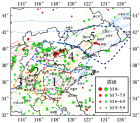
![[ת��]�й�פ�ձ���ʹ�ݽ���֪ͨ �ձ�3.11�ش����](http://image.sciencenet.cn/album/201103/16/092957swxw3gcgyu4wrun6.jpg.thumb.jpg)