近日来,多家国际媒体(包括Natrue, Science, BBC等)对一篇在美国地球物理通讯(Geophysical Research Letter)上发表的 一篇文章 (Substantial contribution of anthropogenic air pollution to catastrophic floods in Southwest China) 广泛报导。该研究模拟了2013年7月8-9发生在我国四川北川多年来最严重的一次强降雨过程。73厘米的超强降雨,冲走了房屋、工厂和桥梁,并引起山体滑坡,造成200人死亡、300000人流离失所。 该研究论文第一作者和通讯作者范霁雯告诉媒体,模拟数据显示,如果2013年7月四川盆地的空气质量改善到1980年代初期的水平,当地山区的总降雨量将减少60%。本文研究显示,空气污染可能改变局部地区大气的稳态,改变空气对流和循环状况,从而对天气和气候的变化产生影响。空气污染严重的情况下,四川盆地的山区在夜间会发生强降雨。与无污染的情况相比,雨势大大加强。 了解更多,欢迎 点击 阅读本研究成果。 作者:范霁雯, Daniel Rosenfeld, Yan Yang, Chun Zhao, L. Ruby Leung, 李占清 Author Information Atmospheric Sciences and Global Change Division, Pacific Northwest National Laboratory , Richland, Washington, USA Institute of Earth Sciences, Hebrew University of Jerusalem , Jerusalem, Israel Chinese Academy of Meteorological Sciences , Beijing, China Department of Atmospheric and Oceanic Science and ESSIC, University of Maryland , College Park, Maryland, USA State Key Laboratory of Earth Surface Processes and Resource Ecology and Joint Center for Global Change Studies, Beijing Normal University, Beijing, China 文章摘要: 极端天气现象更加频繁出现,可能和温室气体和气溶胶的增加有关,其改变了地球的辐射平衡和云的形成过程。2013年7月8日和9日,灾难性的洪水淹没了四川盆地西北部的山区。在对流允许的规模下,我们对气溶胶和大气化学物进行了大气模拟实验。结果显示,气溶胶抑制了原本可能发生在盆地污染源区的降雨,但使得山区的降雨强度大大增加。气溶胶在白天显著削弱了到达地面的太阳辐射,同时增强了大气的辐射吸收,使得盆地大气变得异常稳定,大气中的大量水汽和湿对流不稳定能量被堆积在盆地上空,并随气流传向山区。受地形抬升,这些堆积的水汽和能量被迅速释放出来,在夜间形成异常强烈的降水。我们还发现,四川盆地空气污染的减少能有效缓解洪水强度。因此,气象学中的气溶胶指标很可能提高污染区域天气预报的准确程度。 外媒相关报道: http://news.sciencemag.org/asiapacific/2015/07/catastrophic-chinese-floods-triggered-air-pollution 中文报道: http://www.gcess.cn/xwkx/113017.html
Structural geometry and deformation mechanism of the Longquan anticline inthe Longmen Shan fold-and-thrust belt, eastern Tibet Zhigang Li, Dong Jia, Wei Chen The 2008 Mw 7.9 Wenchuan earthquake is a consequence of ongoing India-Tibet collision and reflects the growth of the Longmen Shan fold-and-thrust belt. In this paper, we present new constraints on the deformation mechanism of the Longmen Shan fold-and-thrust belt, by comparing the physical models to the example of the Longmen Shan fold-and-thrust belt. The result indicates that the deformation mechanism of the belt is mainly dominated by the pre-Sinian layer, whereas locally is controlled by the Lower Triassic layer , such as the Longquan anticline. In addition, we discuss the deformation style of the Longquan anticline various along strike , based on the seismic reflection data, interpretations of structural cross-sections and field observations, as well as physical modeling. The sandbox modeling suggests thatthe deformation of the central segmentof Longquan anticline is likely controlled by higher displacement rate, higher erosion and lower sedimentation, which is incontrast with the southern and northern segment. Moreover, the structural geometry of the central segment of Longquan anticline is more complex than the end-member models of fault-related folds,which is mainly controlled by pure-shear wedge fault-bend fold and bounded by west-verging thrust fault. Combining the studies of the structural geometry, deformation mechanism, and previous studies, we infer that the Longquan anticline is active and potentially seismogenic. Therefore, a quantitative re-evaluation of seismic hazard in Longquan anticline and adjacent area directly beneath the densely populated Sichuan basin is urgently needed. http://www.sciencedirect.com/science/article/pii/S1367912012005792 LQS_JAES.pdf
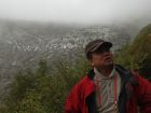
成都号称是中国休闲第一城,据说从飞机上都能听到搓麻将的声音。夸张地说不仅麻将多,还有茶馆多,火锅多,美女多。。。可是我们此行主要是去看四姑娘山,也许堪称大自然的美女。直线距离位于成都西北方向二三百公里,属于川西,靠近西藏和甘肃。成都平原是四川盆地的中心,东南西北四周都有许许多多壮观的自然风光,一次很难逛遍。如果有人想去西藏,建议先来四川锻炼一下,而不是去云南,其中自有道理。 Exploring a corner of Sichuan natural heritage Chengdu city is the capital and center of Sichuan province, one of the most historical central area of an ancient China. Chengdu plain is surrounded by mountains, therefore geographically it's situated at the bottom of the great Sichuan basin. There are numerous marvelous scenic sites in every directions, often with various altitude between 3000-7000 meters high. For instance, famous Jiuzhaigou in the North, Ermeishan and Leshan mountains in the South. The highest snow peak is located in the West, while the most difficult roads may actually be found in the North-east or east, as far as Chongqing, which became autonomous city itself only very recent years, independent away from Sichuan. Geologically those mountains must have been formed around 450 million years ago together with Mount Everest. Luckily, they all have endurable forests and lots of them have snow on the top as well. They have become Sichuan's natural inheritance/heritage. One can imagine our mission this time is towards the West part of the basin, where there is legendary 4 peaks said to be incarnated from 4 beautiful sisters. We drive four wheel mercedes ourselves all the way from the airport, about 20km South-west of Chengdu, directly arrived at one of the hills around the legendary mountain in day 1. However, we only see one slightly sunny day during the next three days, it was either drizzling or cloudy. One will not be able to see the face of the 4-sister-peak if your timing is wrong, and we just had it. We in turn decided to go further towards the West, where there is another mountain area called Gongga, the highest peak there said to be just over 7000 meters. The weather wasn't too brilliant that day either, we werejust about to reach the snow icy views before they were covered by cloud and fog. The holiday is about to finish, we are back in the city in the last day, having some hot pot instead of spring water. There have been long stories to tell, yet let's keep them for the nearfuture... Despite the huge basin, one may dream to have a thorough excursion like a fish if one have just more weeks free... At least, we had a glance/taste of it already.
 标签: 四川盆地