一句话,这个 报告 就是美国过去这些年发言和主张的合编集。 实质内容 就是否定了中国的九段线主权。 背后的警示 是:实际控制是任何主权的前提,领土不是靠法理,而是靠实际控制。 祸害 : 1、肯定了被占岛礁的被占合法性; 2、南海可能成为美国的海洋; 3、没有人居住的钓鱼岛群岛按此理由也要被日本“合理”占有; 4、颠覆了海洋法的管辖时限和范畴,是强者的工具; …… 中国唯一的 有效回应 应该是: 1、立刻在已经控制的岛礁驻防; 2、立刻启动在黄岩岛建设并驻防; 3、立刻拖离仁爱礁上的菲律宾破船; 4、立刻登钓鱼岛建设; 5、在法理上对仲裁庭和法官采取实质行动; …… 海牙仲裁法庭关于南海的仲裁报告 pdf ----------- Historic Rights and the ‘Nine-Dash Line’: The Tribunal found that it has jurisdictionto consider the Parties’ dispute concerning historic rights and the source ofmaritime entitlements in the South China Sea. On the merits, the Tribunalconcluded that the Convention comprehensively allocates rights to maritimeareas and that protections for pre-existing rights to resources wereconsidered, but not adopted in the Convention. Accordingly, the Tribunalconcluded that, to the extent China had historic rights to resources in thewaters of the South China Sea, such rights were extinguished to the extent theywere incompatible with the exclusive economic zones provided for in theConvention. The Tribunal also noted that, although Chinese navigators andfishermen, as well as those of other States, had historically made use of the islands in the South China Sea, there was no evidence that China had historicallyexercised exclusive control over the waters or their resources. TheTribunal concluded that there was no legal basis for China to claim historicrights to resources within the sea areas falling within the ‘nine-dash line’. Status ofFeatures: The Tribunalnext considered entitlements to maritime areas and the status of features. TheTribunal first undertook an evaluation of whether certain reefs claimed byChina are above water at high tide. Features that are above water at high tidegenerate an entitlement to at least a 12 nautical mile territorial sea, whereasfeatures that are submerged at high tide do not. The Tribunal noted that thereefs have been heavily modified by land reclamation and construction, recalledthat the Convention classifies features on their natural condition, and reliedon historical materials in evaluating the features. The Tribunal thenconsidered whether any of the features claimed by China could generate maritimezones beyond 12 nautical miles. Under the Convention, islands generate anexclusive economic zone of 200 nautical miles and a continental shelf, but“ ocks which cannot sustain human habitation or economic life of their ownshall have no exclusive economic zone or continental shelf.” The Tribunalconcluded that this provision depends upon the objective capacity of a feature,in its natural condition, to sustain either a stable community of people oreconomic activity that is not dependent on outside resources or purelyextractive in nature. The Tribunal noted that the current presence of officialpersonnel on many of the features is dependent on outside support and not reflectiveof the capacity of the features. The Tribunal found historical evidence to bemore relevant and noted that the Spratly Islands were historically used bysmall groups of fishermen and that several Japanese fishing and guano miningenterprises were attempted. The Tribunal concluded that such transient use doesnot constitute inhabitation by a stable community and that all of thehistorical economic activity had been extractive. Accordingly, the Tribunalconcluded that none of the Spratly Islands is capable of generating extendedmaritime zones. The Tribunal also held that the Spratly Islands cannot generatemaritime zones collectively as a unit. Having found that none of the featuresclaimed by China was capable of generating an exclusive economic zone, theTribunal found that it could—without delimiting a boundary—declare that certainsea areas are within the exclusive economic zone of the Philippines, becausethose areas are not overlapped by any possible entitlement of China. Lawfulness ofChinese Actions: TheTribunal next considered the lawfulness of Chinese actions in the South ChinaSea. Having found that certain areas are within the exclusive economic zone ofthe Philippines, the Tribunal found that China had violated the Philippines’sovereign rights in its exclusive economic zone by (a) interfering withPhilippine fishing and petroleum exploration, (b) constructing artificialislands and (c) failing to prevent Chinese fishermen from fishing in the zone.The Tribunal also held that fishermen from the Philippines (like those fromChina) had traditional fishing rights at Scarborough Shoal and that China hadinterfered with these rights in restricting access. The Tribunal further heldthat Chinese law enforcement vessels had unlawfully created a serious risk ofcollision when they physically obstructed Philippine vessels. Harm to MarineEnvironment: The Tribunalconsidered the effect on the marine environment of China’s recent large-scaleland reclamation and construction of artificial islands at seven features inthe Spratly Islands and found that China had caused severe harm to the coralreef environment and violated its obligation to preserve and protect fragileecosystems and the habitat of depleted, threatened, or endangered species. TheTribunal also found that Chinese authorities were aware that Chinese fishermenhave harvested endangered sea turtles, coral, and giant clams on a substantialscale in the South China Sea (using methods that inflict severe damage on thecoral reef environment) and had not fulfilled their obligations to stop suchactivities. Aggravation ofDispute: Finally, theTribunal considered whether China’s actions since the commencement of thearbitration had aggravated the dispute between the Parties. The Tribunal foundthat it lacked jurisdiction to consider the implications of a stand-off betweenPhilippine marines and Chinese naval and law enforcement vessels at SecondThomas Shoal, holding that this dispute involved military activities and wastherefore excluded from compulsory settlement. The Tribunal found, however,that China’s recent large-scale land reclamation and construction of artificialislands was incompatible with the obligations on a State during disputeresolution proceedings, insofar as China has inflicted irreparable harm to themarine environment, built a large artificial island in the Philippines’exclusive economic zone, and destroyed evidence of the natural condition offeatures in the South China Sea that formed part of the Parties’ dispute. -----------------
别自以为菲律宾和越南是不起眼的小国 现在的信息真是发达,但是不能利用的话,和没有信息资源是一样的。 在很多“狂妄的”国人眼里,朝鲜、越南、菲律宾都是小国,似乎分分钟就被搞定。然而事实是,中国被这些“小国”搞得鸡飞狗跳。中国在一片“和平”的气氛下,“迎接”了美国航母和驱逐舰。悲观点预测,菲律宾所提南海仲裁案公布结果后,美国可能要切断中国对某些岛礁的有效控制。赶在仲裁案之前发个信息,看看越南菲律宾如何之“小”: 以下信息摘自维基百科 1 、 “The United Stateshas a Special Relationship with the United Kingdom and strong ties with Canada , Australia , New Zealand , the Philippines , Japan , South Korea , Israel ” 2 、人口及排名 Rank Country Population Date % of world population Source 1 China 1,377,406,500 July 8, 2016 18.78% Official population clock 2 India 1,295,170,000 July 8, 2016 17.7%% Unofficial population clock 3 United States 323,940,000 July 8, 2016 4.42% Official population clock 4 Indonesia 258,705,000 July 1, 2016 3.53% Official projection 9 Russia 146,599,183 May 1, 2016 2% Official estimate 10 Japan 126,960,000 June 1, 2016 1.73% Official monthly estimate 12 Philippines 103,275,200 July 8, 2016 1.41% Official population clock 13 Vietnam 92,700,000 July 1, 2016 1.26% Annual Official projection 3 、国土及排名 Rank Sovereign state Total in km 2 (mi 2 ) Land in km 2 (mi 2 ) Water in km 2 (mi 2 ) % water 7000100000000000000♠ 1 Russia 7013170982460000000♠ 17,098,246 (6,601,670) 7013163777420000000♠ 16,377,742 (6,323,482) 7011720500000000000♠ 720,500 (278,200) 4.21 7000300000000000000♠ 3 China 7012957290000000000♠ 9,572,900 (3,696,100) – 7012959696100000000♠ 9,596,961 (3,705,407) 7012932641000000000♠ 9,326,410 (3,600,950) 7011270550000000000♠ 270,550 (104,460) 2.82 7000400000000000000♠ 4 United States 7012952506700000000♠ 9,525,067 (3,677,649) – 7012983351700000000♠ 9,833,517 (3,796,742) 7012914764300000000♠ 9,147,643 (3,531,925) – 7012914759300000000♠ 9,147,593 (3,531,905) 7011221783000000000♠ 221,783 (85,631) – 7011685924000000000♠ 685,924 (264,837) 2.26 – 6.97 7000700000000000000♠ 7 India 7012328726300000000♠ 3,287,263 (1,269,219) 7012286402100000000♠ 2,864,021 (1,105,805) 7011302393000000000♠ 302,393 (116,755) 9.55 7001140000000000000♠ 14 Indonesia 7012190456900000000♠ 1,904,569 (735,358) 7012181156900000000♠ 1,811,569 (699,451) 7010930000000000000♠ 93,000 (36,000) 25.00 7001610000000000000♠ 61 Japan 7011377930000000000♠ 377,930 (145,920) 7011364485000000000♠ 364,485 (140,728) 7010134300000000000♠ 13,430 (5,190) 3.55 7001650000000000000♠ 65 Vietnam 7011331212000000000♠ 331,212 (127,882) 7011310070000000000♠ 310,070 (119,720) 7010211400000000000♠ 21,140 (8,160) 6.38 7001720000000000000♠ 72 Philippines 7011300000000000000♠ 300,000 (120,000) 7011298170000000000♠ 298,170 (115,120) 7011115120000000000♠ 115,120 (44,450) 12.90 4 、 GDP 及排名 List by the InternationalMonetary Fund (2015) Rank Country/region GDP (millions of US$) 1 United States 17,947,000 2 China 10,982,829 3 Japan 4,123,258 7 India 2,090,706 11 South Korea 1,376,868 12 Russia 1,324,734 16 Indonesia 858,953 22 Taiwan 523,581 38 Singapore 292,734 39 Philippines 291,965 49 Vietnam 191,454 5 、在美后裔 “ Filipino Americans ( Filipino : Mga Pilipino Amerikano ) are Americans of Filipino descent and comprise about 3.4 million people, or1.1% of the U.S. population. They are the country's second-largest self-reported Asian ancestry group after Chinese Americans according to 2010 AmericanCommunity Survey ” “ VietnameseAmericans ( Vietnamese : Người Mỹ gốc Việt ) are Americans of Vietnamese descent. They make up about half of all overseasVietnamese ( NgườiViệt Hải Ngoại ) and are the fourth-largest AsianAmerican ethnicgroup and have developed distinctive characteristics in America.”
南海和大西洋发现大量花岗岩说明海底扩张不存在 The granite found in south China sea and the Atlantic show seafloor spreading does not exist 梁光河 一、南海海底发现花岗岩 中国地质调查局地质调查项目《1∶100 万永暑礁幅(C49)海洋区域地质调查》,用拖网于西南海盆水深约3000 m 的1yDG测站(11°29′N、114°04′E)、水深约2800 m 的2yDG 测站(11°47′N、114°56.6′E)和水深约4000 m 的3yDG 测站(114°20′E、13°28′N)获得了一批宝贵的花岗岩和各类沉 积-变质岩的样品(邱燕等,2008)。 这些花岗岩和变质岩样品的测试分析表明,它们的形成时代为109.7 Ma-120 Ma,属于早白垩世晚期。其岩性和地球化学特征与珠江口盆地早期勘探揭露的海底岩石相同,表明它们同属于华南东部中生代花岗岩带的组成部分。 1yDG 测站拖网获得的体积较大的花岗岩岩块,岩性为细粒黑云母花岗岩。1yDG 测站位置远离大陆,水深达3000~4000 m,基本可排除岩块是由人工或水流搬运而来的可能性。花岗岩岩块直径超过20cm,顶面有类似青苔的黑色附着物,表明该面是岩石的暴露面, 附着物是岩石长期与海水接触的结果。2yDG 测站拖网获得了大量直径为3~15cm 的岩石碎块(图1),碎块表面颜色为黑色或褐黑色。碎块成分较杂,主要有石英砂岩、石英岩、云母石英片岩、花岗岩等。3yDG 测站同样获得了块体较大的花岗岩样品,但其岩性与1yDG 测站的略有不同,属于花岗闪长岩(图1)。 位于所谓“古南海洋中脊”附近的3yDG 测站发现大量古老(约110Ma)花岗岩和变质岩,是海底扩张不能给出合乎逻辑解释的,请注意这些花岗岩都发现在斜坡部位,作者推测它们是古华夏陆块曾经在此向北漂移所遗留下来的遗撒物(或同期在陆块尾部形成的产物),它们曾经浅埋在深海海床上。 白垩纪花岗岩主要分布在浙闽粤沿海地区。南海北部陆架至少有10 口井钻遇到白垩纪花岗岩,其中珠江口盆地珠一井在1744~1750 m 处见粗粒肉红色花岗岩,同位素年龄73~76 Ma;珠二井在2270 m 井段处见似斑状黑云母花岗岩,同位素年龄71~76 Ma;珠三井见粗粒黑云母花岗岩,同位素年龄69~70.5 Ma(金庆焕,1989)。此外,莺歌海盆地的莺9 井、琼东南盆地的崖13-1-1井等也钻探到中生代花岗岩。 二、大西洋海底发现大量花岗岩 http://scitech.people.com.cn/n/2013/0508/c1057-21407835.html 中新网2013年5月8日电据新加坡《联合早报》8日报道,巴西地质学家宣布,在距离巴西首都里约热内卢约1500公里的大西洋海床上发现大片花岗岩,可能证明类似“亚特兰蒂斯”的失落大陆确实存在。 巴西地质勘探局一名高级官员桑托斯说,研究人员两年前在巴西及国际水域之间的一处海底山脉“里约大海隆”(Rio Grande Elevation)进行挖掘作业时,采集到一些花岗岩样本。 此次调查使用了日本海洋研发机构的载人潜水器“深海6500”,是载人潜艇首次在南大西洋展开调查活动。最终在水深910米处发现高宽约10米的岩崖。经过影像分析确认为花岗岩,此外其周围还有大量无法在海底形成的石英砂。 根 据地幔对流模型,大洋中脊是地幔上升岩流顶托大洋地壳裂开形成新洋壳的地方,距离大洋中脊越近洋壳越新,而且大洋中脊附近的新洋壳都是玄武岩。但是,除了以上新发现,前人大量的观测事实证明,大西洋中脊附近存在古老的花岗岩和浅水灰岩(在大西洋中脊附近发现有15-16亿年前的花岗岩、中侏罗世浅水灰岩)。按照海底扩张,整个大西洋洋底的岩石年龄不应该超过两亿年,而这些镶嵌在大西洋中脊上的浅水灰岩和花岗岩的年龄却高达几亿年乃至十几亿年。这些观测事实用板块构造难以给出合乎逻辑的解释。 不符合事实的海底扩张假说模型 大洋中 多处发现斜长花岗岩,传统观点认为这些斜长花岗岩是玄武岩分异结晶成因。但在南印度洋发现的斜长花岗岩地球化学投点显示,它们大多落在大洋盆地构造环境中(Koepke,2007),因此Koepke认为所谓的分异结晶可能并不存在。如果按照新大陆漂移模型来解释,就比较简单,这些斜长花岗岩是玄武岩与沉积岩混溶成因。 阅读下面链接中的文章也许会改变您很多看法: http://hi.baidu.com/liangguanghe1 参考文献: (1)邱燕, 陈国能, 刘方兰, 彭卓伦,南海西南海盆花岗岩的发现及其构造意义,地质通报,2008,No.12:2104-2107 (2)金庆焕.南海地质与油气资源 .北京:地质出版社,1989:151-219.
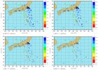
Long-term cycles in thecarbon reservoir of the Quaternary ocean: a perspective from the South China Sea http://nsr.oxfordjournals.org/content/1/1/119.abstract Hot! 由同济大学汪品先院士作为第一作者和通讯作者撰写的综述文章 Long- termcycles in the carbon reservoir of the Quaternary ocean: a perspective from the South China Sea (译名:从南海看第四纪大洋碳循环的长周期)已在 National Science Review ( NSR ) 2014 年 3 月份的创刊号 上发表。 第四纪古气候研究的重点在于冰期旋回,地球轨道的周期性变化引起了 4 万年到 10 万年的冰期 / 间冰期的交替。近年来随着深海和冰芯等研究的进展,第四纪高分辨率的记录延伸到了百万年的尺度,结果发现在冰期旋回之上叠加着更长的周期,因而即使在轨道参数相似的条件下,各个间冰期也可以有显著的不同。本篇综述,是在南海大洋钻探 184 航次发现碳同位素( d 13 C )长周期( 10 5 年)的基础上,论证在地球系统的水循环(冰盖变化)和碳循环(海洋生物地球化学变化)中,普遍存在这类长周期,而两者之间的相互联系,导致了第四纪气候环境变化的一系列重大事件。 1999 年南海大洋钻探 184 航次, 发现最近百万年来的深海沉积有 d 13 C 的 50 万年左右的长周期,并且普遍存在于世界各大洋(图 1 ),属于大洋碳储库的长期变化的反映。其实在早于 160 万年的大洋地层中,广泛存在着 d 13 C 的 40 万年长偏心率周期,同时也呈现于碳酸盐保存和多种生物地球化学的记录之中,推测是偏心率调控下全球季风演变的反映。具体说,低纬轨道驱动的全球季风,控制着陆地向海洋输送营养物质的数量,改变了海洋中颗粒有机碳与溶解有机碳的比例( POC/DOC ),进而引起 d 13 C 的 40 万年周期变化。 图 1 : 160 万年以来大洋碳储库变化的三大阶段。 (A) 南海大洋钻探 ODP 1143 井碳同位素重值 (δ 13 C max ) 事件划分的三大阶段; (B) 亚热带南大西洋磁化率数据划分的三大阶段: 10 万年周期阶段、过渡期和 4 万年周期阶段; (c) 地球轨道偏心率。 到了距今 160 万年前,大洋环流发生重大改组,南大洋由于深层水与上层水体隔离,形成全球最大的海洋碳储库。从此以后,大洋碳储库不但受到低纬季风演变的影响,还要受到两极冰盖消长的控制,使得海洋 d 13 C 记录中的 40 万年长周期“延长”到 ~50 万年(图 1 );反之,大洋碳储库的变化又会促使冰期旋回转型。近百万年来,地球气候冰期旋回经历了两次转型: 90 万年前的 “ 中更新世转型 ” ( MPT ),和 40 万年前的 “ 中布容 ” 事件( MBE ),结果都是北极冰盖的变幅增大。而两次转型之前都是先有南极融冰事件,再有大洋碳储库的碳同位素重值期( d 13 C max-III 和 d 13 C max-II ),然后才是北极冰盖变幅剧增,实现冰期旋回的转型(图 2 )。由此推测:第四纪以来北极冰盖消长转型的根源,或许还在于南大洋海流改组造成的大洋碳循环长周期变化(附表)。 图 2 : 南海大洋钻探 ODP 1143 井记录的晚更新世重大事件。 (A) 底栖有孔虫氧同位素; (B) 底栖有孔虫碳同位素; (C) 小型颗石藻 Gephyrocapsa 丰度; (D) 表层海水温度。红色方框指示两组事件: I 为碳同位素重值期 δ 13 C max III 与中更新世转型 MPT , II 为碳同位素重值期 δ 13 C max II 与 “ 中布容 ” 事件 MBE 。碳同位素重值期用黄色阴影标出, MPT 和 MBE 用蓝色阴影标出。 附表: 第四纪 气候转型过程中的两组重要 事件,发生顺序用深海氧同位素期次进行编号 事件 MPT MBE 表层海水温度 西南极冰盖融化 31 15-13 南半球变暖 碳同位素重值期 29-25 13 保持相对温暖 北极冰盖扩张 22 12 急剧变冷 北极冰盖融化 21 11 急剧变暖 原文详见 National Science Review 网站: REVIEWS: GEOSCIENCES PinXian Wang, QianYu Li, Jun Tian, ZhiMin Jian, ChuanLian Liu, Li Li and WenTao Ma Long-term cycles in the carbon reservoir of the Quaternary ocean: a perspective from the South China Sea Natl Sci Rev nwt001 first published online December 31, 2013 doi:10.1093/nsr/nwt028 (25 pages) o Abstract o Full Text (HTML) o Full Text (PDF)
Alfvn ,大名鼎鼎的 Nobel Laureate ,怎么会同近日出没我国南海的美国情报船 Impeccable 扯上关系了?别急,且听笔者慢慢道来。 Hannes Alfvn ,瑞典物理学家, 1970 年 Nobel 物理奖得主;也是唯一的瑞典籍物理奖得主和唯一的等离子体物理领域的物理奖得主。当然, 1993 年的物理奖得主之一 Russell A. Hulse 得奖当时正在 Princeton Plasma Physics Lab 工作,算得上等离子体物理学家。但是他的 citation 是: for the discovery of a new type of pulsar, a discovery that has opened up new possibilities for the study of gravitation ,所以应该算天体物理或宇宙学方面的工作。而 Alfvn 的 citation 则是: for fundamental work and discoveries in magnetohydrodynamics with fruitful applications in different parts of plasma physics ,货真价实的等离子体物理! 关于 Alfvn 的物理奖,一直是科学界的一个争论的话题。很有一些人觉得他的工作得奖,与其国籍不无关系。但是笔者认为,以这位前辈物理学家命名的 Alfvn 波,确是对物理学乃至科学技术发展的一个重要贡献。 这要先说说最近引起世界注目的美国情报船 Impeccable 。据说这艘船是来搜集南海地区潜艇通信情报的。 世界大国的威慑打击力量,特别是第二次打击力量,核潜艇是一个关键的组成部分。而潜艇的长距离水下通讯以及对周围目标的长距离侦测,一直是难以解决的尖端问题。 人类相互之间的通信联络和对周围世界的认识,离不开波。在地球环境这样的介质中,主要就是声波和电磁波。所谓眼观六路、耳听八方,就是利用眼睛对在物体上反射(或发射)的可见光接受和耳朵对声波的感知。但是要实现远距离的快速通讯,还是要靠电磁波。古代的烽火台和现在的各种无线通讯手段都是依靠电磁波的长距离、弱衰减的快速传播。有线的通讯手段也是在导体或光介质中传播电磁波(或者电磁波通过模式转换而成的静电波)。 但是在水下(特别是海水中),电磁波衰减得很厉害。这主要是水(特别是海水)是弱电离、强碰撞的。不同频率的电磁波在这样的介质中会激发带电粒子不同的振荡模式。而这些振荡因为与水分子的热碰撞而很快衰减。越是高频的电磁波,越容易激发带电粒子的高频振荡模式,使得电磁波在水中的衰减长度越短。有人把这种现象比做金属对电磁场的屏蔽效应。但它们在物理上不一样。后者主要是因为其很高的截止频率(这个问题我们以后有机会再详细说),而电磁波在海水中的衰减与前几年大家谈论的等离子体隐身的原理类似。 正因为海水的这个特性,潜艇的水下通讯和侦测主要靠声纳。但是声波在水中也很难传得远。特别是岸基的指挥系统如何同远在地球另一半的核潜艇进行通信联络?这是各国海军、特别是核大国海军面临的一大难题。
 标签: 南海
![[转载]视频:实拍我海监船巡航南海逼退外国公务船](http://image.sciencenet.cn/album/201207/03/165623spb470rcrprglgqo.jpg.thumb.jpg)

![[转载]环球时报:在南海中国不想惹事更不怕事,但不放弃抗议?](http://image.sciencenet.cn/album/201112/31/17442370mhr30z10ze700q.jpg.thumb.jpg)
![[转载]2011年第一批中国海域石油勘探开发开放区块](http://image.sciencenet.cn/album/201111/02/143419hzpsdwvhhktjhqv3.jpg.thumb.jpg)