博文
Matlab: use GSHHS/GSHHG coastline data in M_Map
||||
1. Download GSHHS coastline bin data archive with the name starting at gshhg-bin from NOAA (美国国家海洋和大气管理局): http://www.ngdc.noaa.gov/mgg/shorelines/data/gshhg/latest/
2. Uncompress the data archive in the folder /Applications/MATLAB_R2015a.app/toolbox/m_map/private
3. Use it.
e.g. m_gshhs_i('patch',[.5 .5 .5]);
m_gshhs_f - full resolution;
m_gshhs_h - high resolution;
m_gshhs_i - intermediate resolution;
m_gshhs_l - low resolution;
m_gshhs_c - crude resolution.
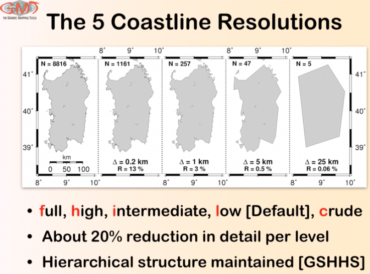
As distributed, GSHHS consists of a hierarchical set ofdatabasesat different resolutions. The lowest or "crude" resolution is not as good as the M_Map database, although it contains many more inland lakes. The"high" resolution consists of points about 200m apart. There is also an even finer "full" resolution. You can install part or all of the database(depending on how much disk space you have available). The "full"resolution occupies 90Mb of disk space, and successively coarserresolutions are smaller by about 1/4. Thus "high" resolution occupies 21Mb, "intermediate" uses 6Mb, and "low" uses 1.1Mb (one reason for notalways using "high" resolutionis that the entire 90Mb database must be read and processed each call,which may take some time).
他人观点:https://wislab.net/archives/384.html
关于图像平滑
MATLAB 绘图时默认启用图像平滑功能,故输出的海岸线会被平滑(抗锯齿)处理。如果需要输出精确海岸线图像,可使用命令 set(gcf,'GraphicsSmoothing','off'); 关闭平滑功能。
https://m.sciencenet.cn/blog-3031432-1001318.html
上一篇:Matlab: install M_Map in mac
下一篇:Python: operators