博文
如何把新数据点加到已有DEM图中 或合并两个DEM图像
||||
如何把新的数据点(如excel格式等)合并到已有DEM图中
或者合并两个DEM图像
目的:对一个矿/工区,很容易搞到老的DEM图像(网上免费下载)/地形(或化探等)等高线图,
如果想把补做的化探数据添加到老的等高线或者DEM图像中,
或者
如果想把勘查过程中的钻孔、槽探点、以及测量控制点等添加到老的等高线或者DEM图像中,
可用此办法
方法一 把新数据(如excel格式等)加到老DEM中法 使用Discover
Step 1 to convert DEM to ASSII (e.g., csv file) with
Surfaces>Export Grid File or Contours>Export Grid to ASCII File (如CSV格式文件)
Step 2 to merge the additional data points (e.g.csv格式文件) into the above ASCII file
Step 3 To input and create points with the new ASCII file in MapInfo Map Window
Step 4 To delete unwanted data points within the overlapped areas in MapInfo Map Window
Step 5 Surfaces>CreateGrid>Interactive.......
这样就得到由新数据更新的DEM数据了。
备注:
如果原来的DEM不是DEM格式,而是等高线格式,则要使用下述步骤把等高线图变成DEM
Surfaces>Create Grid>Interactive
方法二 直接合并2个DEM法 ----使用 Global Mapper,
Combine Terrain Options, to combine two DEMs
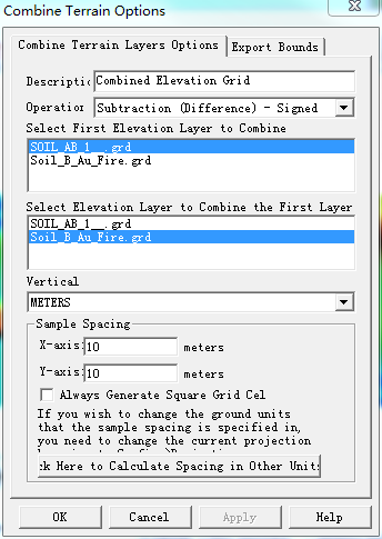
然后选择合并方法(Operation下拉菜单):
Addition - values from each layer are added to eachother
Subtraction (Difference) - Signed - value in new layer is assigned to the difference between the value in the first layer and the value in the second layer·
Subtraction (Difference) - Unsigned - value in new layer is assigned to the magnitude (absolute value) of the difference between the value in the first layer and the value in the second layer·
Average Elevation - value in new layer is assigned to the average of the value in the first layer and the value in the second layer·
Minimum Elevation - value in new layer is assigned to the smaller of the value in the first layer and the value in the second layer·
Maximum Elevation - value in new layer is assigned to the larger of the value in the first layer and the value in the second layer·
Multiply Values - value in new layer is assigned to the product of the value in the first layer and the value in the second layer·
Divide 1st Value by 2nd - value in new layer is assigned to the value from the first layer divided by the value in the secondlayer. If either value is missing or the second layer value is zero the new sampleis marked as invalid.
https://m.sciencenet.cn/blog-856115-1011198.html
上一篇:MapInfo/Discover做图快捷键(1)
下一篇:如何生成在AutoCAD中可直接加载的3D等高线